Balearic Sea
Coordinates: 40°0′N 1°30′E / 40.000°N 1.500°E
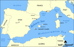
The Balearic Sea (endotoponym: Mar Balear in Catalan and Spanish) is a body of water in the Mediterranean Sea near the Balearic Islands.[1] It is not to be confused with the Alboran sea or the Iberian shelf waters. The Ebro River flows into this small sea.
Islands and archipelagoes
Baleraic islands are divided into 2 groups : Gimnesias in the North, and Pitiusas in the South-West.[2]
Gimnesias
Pitiusas
Extent
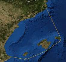
The International Hydrographic Organization defines the limits of the Balearic Sea as follows:[3]
Between the Islas Baleares and the coast of Spain, bounded:
On the Southwest. A line from Cape San Antonio, Spain (38°50′N 0°12′E / 38.833°N 0.200°E) to Cabo Berberia, the Southwest extreme of Formentera (Islas Baleares).
On the Southeast. The South Coast of Formentera, thence a line from Punta Rotja, its Eastern extreme, to the Southern extreme of Isla Cabrera (39°07′N 2°54′E / 39.117°N 2.900°E) and to Isla del Aire, off the Southern extreme of Menorca.
On the Northeast. The East coast of Menorca up to Cap Favaritx (40°00′N 4°14′E / 40.000°N 4.233°E) thence a line to Cabo San Sebastian (Spain) (41°54′N 3°10′E / 41.900°N 3.167°E).
References
- ↑ C.Michael Hogan. 2011. Balearic Sea. Encyclopedia of Earth. Eds. P.Saundry & C.J.Cleveland. National Council for Science and the Environment. Washington DC
- ↑ "Balearic Islands Map / Geography of Balearic Islands / Map of Balearic Islands - Worldatlas.com". www.worldatlas.com. Retrieved 2017-11-09.
- ↑ "Limits of Oceans and Seas, 3rd edition" (PDF). International Hydrographic Organization. 1953. Retrieved 28 October 2016.