Avalon Peninsula
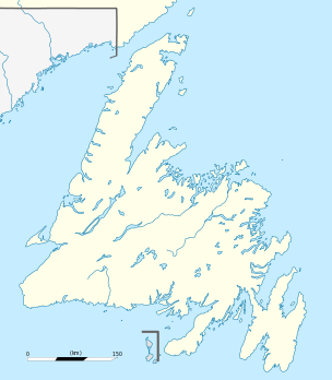
The Avalon Peninsula is a large peninsula (9,220 km²[1]) that makes up the southeast portion of the island of Newfoundland.
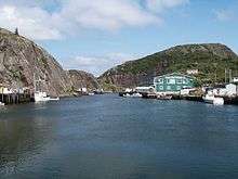
The peninsula is home to 262,410 people, about 51% of Newfoundland's population, according to the Canada 2011 Census. The peninsula is the location of St. John's, the provincial capital and largest city.[2] It is connected to the main section of the island by the 5 km (3 mi) wide Isthmus of Avalon. The peninsula protrudes into the rich fishing zones near the Grand Banks. Its four major bays—Trinity Bay, Conception Bay, St. Mary's Bay, and Placentia Bay—have long been the centre of Newfoundland's fishing industry.
Geography and geology

The Avalon Peninsula is itself pinched into peninsulas by St. Mary's Bay and Conception Bay. St. John's is located in the northeast of the peninsula.
The Avalon Peninsula is a noted region for Precambrian fossils, and many Lagerstätten of the diverse Ediacaran biota are found on the peninsula. Mistaken Point is the original location of the first documented Ediacaran, Aspidella terranovica (which gets its specific name from Newfoundland). The peninsula gives its name to the ancient micro-continent Avalonia of which it was part.
History
In 1497, explorer John Cabot led an expedition from England in an attempt to reach the Spice Islands in the East Indies, that supposedly ended up off what is now Bonavista. The first permanent English settlement was established at Cuper's Cove in 1610. Sir George Calvert was later given a large land holding on the peninsula. The initial colony of Ferryland grew to a population of 100, becoming the first successful permanent settlement on Newfoundland island. In 1623 Calvert was given a Royal Charter extending the Royal lands and granting them the name Province of Avalon "in imitation of Old Avalon in Somersetshire wherein Glassenbury stands, the first fruits of Christianity in Britain as the other was in that party of America". Calvert wished to make the colony a refuge for Roman Catholics facing persecution in England. In 1625 Calvert was made the first Lord Baltimore.
A series of crises and calamities led Calvert to quit the colony in 1629 for "some other warmer climate of this new world", which turned out to be Maryland, though his family maintained agents to govern Avalon until 1637, when the entire island of Newfoundland was granted by charter to Sir David Kirke and James Hamilton, 1st Duke of Hamilton.
In 1696, during King William's War, the French destroyed many English villages in the Avalon Peninsula Campaign.
During Queen Anne's War, Rear Admiral John Leake of the Royal Navy led an expedition aimed at capturing French ships around the Peninsula and burning French settlements. The expedition was largely successful. During this same conflict, the French attacked the fortified English port of St. John's, but were defeated. They later returned and captured the town, burning it to the ground.
Later, during King George's War, a single British Man-of-war, HMS Kinsale, cruised along the coast, attacking and capturing French ships.
On June 8th, 1755, three British- and three French warships met off Cape Race on the Peninsula and engaged each other in battle (although both countries were at peace). This battle was one of a series that ignited the French and Indian War in North America. The war also ironically ended in Newfoundland, at the decisive Battle of Signal Hill, in which British soldiers and artillery under the command of William Amherst drove the French occupants of St. John's from Signal Hill and into the town's fort, where they soon surrendered.
The Peninsula played a large role in both the American Revolutionary War and the War of 1812, in which it served as a training ground for Royal Navy sailors and marines.
See also
References
- ↑ "Avalon Peninsula". The Canadian Encyclopedia. Archived March 7, 2008, at the Wayback Machine.
- ↑ "Census Profile - Avalon Peninsula". Statistics Canada. Retrieved 6 January 2013.