Gambier Islands
| Native name: Îles Gambier | |
|---|---|
 | |
 The Gambier Islands form the easternmost part of French Polynesia | |
| Geography | |
| Location | Pacific Ocean |
| Archipelago | Polynesia |
| Total islands | 14 |
| Major islands | Mangareva, Akamaru, Aukena, Taravai |
| Area | 29.6 km2 (11.4 sq mi) |
| Administration | |
|
France | |
| Overseas collectivity | French Polynesia |
| Demographics | |
| Population | 1319 (2016) |

The Gambier Islands (French: Îles Gambier or Archipel des Gambier) are a populated (1319 people), small (30 km2 or 12 sq mi) group of islands, remnants of a caldera along with islets on the surrounding fringing reef, in French Polynesia, located at the southeast terminus of the Tuamotu archipelago. They are generally considered a separate island group from Tuamotu both because their culture and language (Mangarevan) are much more closely related to those of the Marquesas Islands, and because, while the Tuamotus comprise several chains of coral atolls, the Gambiers are of volcanic origin with central high islands.
Geography
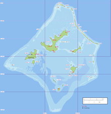
The Gambier Islands include the Mangareva Islands (the Gambier Islands proper), which have an enclosing coral reef which is broken by only three passages to the open sea. Besides Mangareva, the other notable high islands of the group are Akamaru, Angakauitai, Aukena, Kamaka, Kouaku, Makapu, Makaroa, Manui, Mekiro and Taravai. These are primarily of volcanic origin. A number of others are actually coral islands, hence of secondary volcanic origin, including Papuri, Puaumu, Totengengie and the Tokorua group.
The Mangareva Islands are located at 23°09′S 134°58′W / 23.150°S 134.967°W and are approximately 26.6 km² in area. The total population in 2016 was 1319. The primary town is Rikitea, located on Mangareva, as is the highest point in the Gambiers, Mt. Duff, rising to 441 metres (1,447 ft) along that island's south coast.

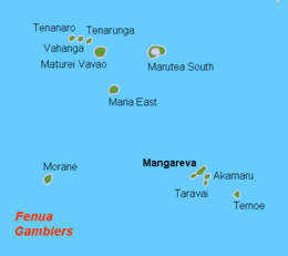
The islands of Gambier comprises:
- Temoe atoll: one main island and a dozen motus separated by passes over the coral reef.
- Mangareva Islands
- islands in the central lagoon (only high islands are permanently inhabited):
- to the north, the high island of Mangareva (the largest island of the atoll), and the islet of Rumarei;
- to the north-east, the high island of Aukena;
- to the south-east, the high island of Akamaru, the two smaller islands Makapu, Mekiro, and the two islets of Atumata, Teohootepohatu;
- to the south, the high island of Kamaka, the two smaller islands of Makaroa, Manui, and the islet of Motu Teiku;
- to the west, the high islands of Taravai and Angakauitai, and the islets of Tepu Nui and Motu-O-Ari;
- low islands on the coral reef (none of them are inhabited):
- to the north-west, the islet of Tenoko;
- to the north, the islet of Papuri; the three islands of Teauaone, Tepapuri and Puaumu;
- to the north-east, the four islets of Vaiatekeue, Teauotu, Apou, and Tuaeu; the three islands of Totegegie (location of the Totegegie Airport), Tarauru Roa, Gaioio;
- to the east, the two islets of Tauna and Tekava;
- to the south-east, the island of Kouaku;
- to the west, the reef of Tokorua (occasionally emerging).
- islands in the central lagoon (only high islands are permanently inhabited):
History
Approximately from the 10th to the 15th centuries, the Gambiers hosted a population of several thousand people and traded with other island groups including the Marquesas, the Society Islands and Pitcairn Islands. However, excessive logging by the islanders resulted in almost complete deforestation on Mangareva, with disastrous results for the islands' environment and economy. The folklore of the islands records a slide into civil war and even cannibalism as trade links with the outside world broke down, and archaeological studies have confirmed this. Today, the islands can support a population of only a few hundred.
In 1834, the French Picpus priests Honoré Laval and François Caret with their assistant Columba Murphy founded a Roman Catholic mission in the Gambiers. After their success here, they moved to Tahiti in 1836.
Mangareva along with its dependencies in the Gambier Islands were ruled by a line of kings and later regents that ruled until the French formally annexed the islands in 1881. A French protectorate was requested on 16 February 1844 by King Maputeoa but was never ratified by the French government. On 4 February 1870, Prince Regent Arone Teikatoara and the Mangarevan government formally withdrew the protectorate request and asked the French to not intervene in the kingdom's affairs. After Father Laval was removed to Tahiti, the native government changed their stance and an agreement between the native government and the French colonial authority in Tahiti was signed reaffirming the protectorate status on 30 November 1871. The Gambier Islands were finally annexed on 21 February 1881 under Prince Regent Bernardo Putairi and approved by the President of France on 30 January 1882.[1]
Effects of French nuclear testing
The Gambiers served as a logistical staging base for French nuclear testing activity in Mururoa, approximately 400 kilometers away. During this time, the French military dragged a chain through some of the coral reef beds to cut a wider and deeper channel for deep draft vessels. Higher rate of infections by ciguatera were subsequently recorded.[2]
French military vessels visited the area (as of 1993) every six months collecting specimens of water, food, human hair and other material, as well as taking detailed accounts of births, deaths and other demographic events, presumably for on-going research into the effects of the nuclear testing. The results of this research are not published.
According to French Polynesian doctors who have worked in the area, considerably higher than normal incidences of cancer and thyroid problems are found amongst Polynesians who live near the Moruroa atoll.
Gallery


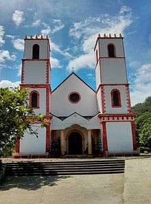 St. Michael's Cathedral in Rikitea, the largest church in the South Pacific built to seat 1200.
 Arch at the old Rouru Convent
 Tomb of King Maputeoa
See also
Notes
- ↑ Gonschor, Lorenz Rudolf (August 2008). Law as a Tool of Oppression and Liberation: Institutional Histories and Perspectives on Political Independence in Hawaiʻi, Tahiti Nui/French Polynesia and Rapa Nui. Honolulu: University of Hawaii at Manoa. pp. 56–59. hdl:10125/20375.
- ↑ Vincent, Lindsay (2006-01-01). "French accused of Pacific nuclear cover-up". London: The Guardian. Retrieved 2008-05-12.
References
- Jared Diamond, Collapse: How Societies Choose to Fail or Succeed (2005), Ch. 3
External links
| Wikimedia Commons has media related to Gambier Islands. |
| Wikivoyage has a travel guide for Gambier Islands. |
- Atoll list (in French)
- Death of a People. A look at the decline of Mangareva and the missionary influence on the people of the Gambiers.
Tuamotus Gambiers | Islands/Atolls | ||
|---|---|---|---|
| Island groups | |||
| Polynesian triangle | |
|---|---|
| Polynesian outliers | |
| Polynesian-influenced | |
| |