Kermadec Islands
The Kermadec Islands /kərˈmædɛk/ (Rangitāhua in Māori[1]) are a subtropical island arc in the South Pacific Ocean 800–1,000 km (500–620 mi) northeast of New Zealand's North Island, and a similar distance southwest of Tonga. The islands are part of New Zealand, 33 km2 (12.7 sq mi) in total area and nowadays uninhabited, except for the permanently manned Raoul Island Station, the northernmost outpost of New Zealand.
The islands are listed with the New Zealand Outlying Islands. The islands are an immediate part of New Zealand, but not part of any region or district, but instead Area Outside Territorial Authority, like all the other outlying islands except the Solander Islands.
History
Polynesian people settled the Kermadec Islands in around the 14th century (and perhaps previously in the 10th century),[2] but the first Europeans to reach the area—the Lady Penrhyn in May 1788—found no inhabitants. The islands were named after the Breton captain Jean-Michel Huon de Kermadec, who visited the islands as part of the d'Entrecasteaux expedition in the 1790s. European settlers, initially the Bell family, lived on the islands from the early nineteenth century until 1937, as did whalers. One of the Bell daughters, Bessie Dyke, recounted the family's experience there to writer Elsie K. Morton, who published the story in 1957 as Crusoes of Sunday Island.[3]
Raoul Island Station
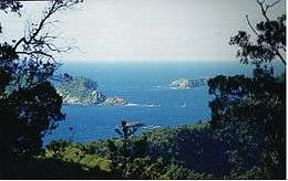
The Station consists of a government meteorological and radio station, and a hostel for Department of Conservation officers and volunteers, that has been maintained since 1937. It lies on the northern terraces of Raoul Island, at an elevation of about 50 m (160 ft), above the cliffs of Fleetwood Bluff. It is the northernmost inhabited outpost of New Zealand.
Nuclear Testing Proposals
In 1955 the British Government required a large site remote from population centres to test the new Thermonuclear devices it was developing. Various islands in the South Pacific and Southern Oceans were considered, along with Antarctica. The Admiralty suggested the Antipodes Islands.[4]. In May 1955, the Minister for Defence, Selwyn Lloyd, concluded that the Kermadec Islands would be suitable. They were part of New Zealand,so Eden wrote to the Prime Minister of New Zealand, Sidney Holland, to ask for permission to use the islands. Holland refused, fearing an adverse public reaction in the upcoming 1957 general election in New Zealand. Despite reassurances and pressure from the British government, Holland remained firm.[5]
Geography
The islands lie within 29° to 31.5° south latitude and 178° to 179° west longitude, 800–1,000 km (500–620 mi) northeast of New Zealand's North Island, and a similar distance southwest of Tonga. The centre of the Kermadec Islands group is located at approximately 29°16′37″S 177°55′24″W / 29.27694°S 177.92333°WCoordinates: 29°16′37″S 177°55′24″W / 29.27694°S 177.92333°W. The total area of the islands is 33.08 km2 (12.77 sq mi).
Climate
The climate of the islands is subtropical, with a mean monthly temperature of 22.4 °C (72.3 °F) in February and 16.0 °C (60.8 °F) in August. Rainfall is approximately 1,500 mm (60 in) annually, with lower rainfall from October through January.
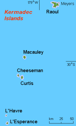
Islands
The group includes four main islands (three of them might be considered island groups, because the respective main islands have smaller islands close by) and some isolated rocks, which are, from north to south:
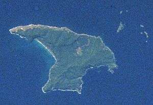
- Raoul Island or Sunday Island is by far the largest of the islands. It is located at 29°16′0″S 177°55′10″W / 29.26667°S 177.91944°W, 900 km (560 mi) south-southwest of 'Ata, the southernmost island of Tonga, and 1,100 km (680 mi) north-northeast of New Zealand. Raoul Island has an area of 29.38 km2 (11.34 sq mi) with numerous smaller satellite islands; Moumoukai peak, is 516 m (1,693 ft) high
- Macauley Island, the second largest, is located at 30°14′S 178°26′W / 30.233°S 178.433°W, 110 km (68 mi) south-southwest of Raoul Island, Mount Haszard with an elevation of 238 m (781 ft), area 3.06 km2 (1.18 sq mi) with neighbouring island: Haszard Island.
- Macdonald Rock is about 4 km (2.5 mi) north of Macauley Island at 30°11′S 178°26′W / 30.183°S 178.433°W.[6]
- Curtis Island, the third largest, is located at 30°32′32″S 178°33′39″W / 30.54222°S 178.56083°W, 35 km (22 mi) south-southwest of Macauley Island, 137 m (449 ft) high, area 0.59 km2 (0.23 sq mi) with neighbouring Cheeseman Island.
- Nugent Island is the northernmost island. It is located at 29°13′54″S 177°52′09″W / 29.23167°S 177.86917°W. It is approximately 100 metres (109 yd) across.
- L'Esperance Rock, formerly French Rock, is 80 km (50 mi) south-southwest of Curtis Island at 31°26′S 178°54′W / 31.433°S 178.900°W, 250 m (820 ft) in diameter, 0.05 km2 (0.019 sq mi) in area, 70 m (230 ft) high.
- L'Havre Rock, about 8 km (5.0 mi) north-northwest of L'Esperance Rock near 31°21′S 178°59′W / 31.350°S 178.983°W (submerged, barely above water during low tide)
Seamounts north and south of the Kermadec Islands are an extension of the ridge running from Tonga to New Zealand (see Geology).
- Star of Bengal Bank, 103 km (64 mi) south-southwest of L'Esperance Rock, with a least depth of 48 metres (157 ft)
Geology
.jpg)
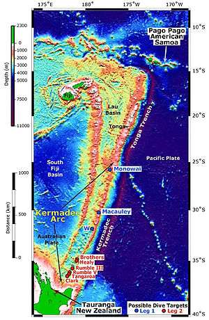
The islands are a volcanic island arc, formed at the convergent boundary where the Pacific Plate subducts under the Indo-Australian Plate. The subducting Pacific Plate created the Kermadec Trench, an 8 km deep submarine trench, to the east of the islands. The islands lie along the undersea Kermadec Ridge, which runs southwest from the islands towards the North Island of New Zealand and northeast towards Tonga (Kermadec-Tonga Arc).
The four main islands are the peaks of volcanoes that rise high enough from the seabed to project above sea level. There are several other volcanoes in the chain that do not reach sea level, but form seamounts with between 65 and 1500 m of water above their peaks. Monowai Seamount, with a depth of 120 m over its peak, is midway between Raoul Island and Tonga. 100 km south of L'Esperance Rock is the little-explored Star of Bengal Bank, probably with submarine volcanoes.
Further south are the South Kermadec Ridge Seamounts, the southernmost of which, Rumble IV Seamount, is just 150 km North of the North Island of New Zealand. The ridge eventually connects to White Island in New Zealand's Bay of Plenty, at the northern end of the Taupo Volcanic Zone. The islands experience many earthquakes from plate movement and volcanism.
Raoul and Curtis are both active volcanoes. The volcanoes on the other islands are currently inactive, and the smaller islands are the eroded remnants of extinct volcanoes.
From 18 to 21 July 2012, Havre Seamount (near Havre Rock) erupted, breaching the ocean surface from a depth of more than 1100 m and producing a large raft of pumice floating northwest of the volcano. The eruption was not directly observed, but it was located using earthquake and remote sensing data after the pumice raft was spotted by aircraft and encountered by HMNZS Canterbury.[7]
Environment
Flora
The islands are recognised by ecologists as a distinct ecoregion, the Kermadec Islands subtropical moist forests. They are a tropical and subtropical moist broadleaf forests ecoregion, part of the Oceania ecozone. The forests are dominated by the red-flowering Kermadec pōhutukawa, related to the pōhutukawa of New Zealand. The islands are home to 113 native species of vascular plants, of which 23 are endemic, along with mosses (52 native species), lichens and fungi (89 native species). Most of the plant species are derived from New Zealand, with others from the tropical Pacific. 152 non-native species of plants introduced by humans have become established on the islands.
Dense subtropical forests cover most of Raoul, and formerly covered Macauley. Metrosideros kermadecensis is the dominant forest tree, forming a 10 – 15-meter high canopy. A native nikau palm (Rhopalostylis baueri) is another important canopy tree. The forests had a rich understory of smaller trees, shrubs, ferns, and herbs, including Myrsine kermadecensis; Lobelia anceps, Poa polyphylla, Coprosma acutifolia, and Coriaria arborea. Two endemic tree ferns, Cyathea milnei and the rare and endangered Cyathea kermadecensis, are also found in the forests.
Areas near the seashore and exposed to salt spray are covered by a distinct community of shrubs and ferns, notably Myoporum obscurum, Coprosma petiolata, Asplenium obtusatum, Cyperus ustulatus, Disphyma australe, and Ficinia nodosa.
Fauna
The islands have no native land mammals. An endemic bird subspecies is the Kermadec red-crowned parakeet. The group has been identified as an Important Bird Area (IBA) by BirdLife International because of its significance as a breeding site for several species of seabirds, including white-necked and black-winged petrels, wedge-tailed and little shearwaters, sooty terns and blue noddies.[8] The area also hosts rich habitats for cetaceans.[9] In recent years, increased presences of humpback whales indicate Kermadec Islands functioning as migratory colliders, and varieties of baleen (not in great numbers) and toothed whales including minke whales,[10] sperm whales, less known beaked whales, killer whales, and dolphins frequent in adjacent waters.[11][12] Vast numbers of southern right whales were historically seen in southwestern areas although only a handful of recent confirmations exist around Raoul Island.[13] The deep sea hydrothermal vents along the Kermadec ridge support diverse extremophile communities including the New Zealand blind vent crab.[14]
Conservation
The introduction of cats, rats, and goats devastated the forests and seabirds.[15][16] Overgrazing by goats eliminated the forests of Macauley Island, leaving open grasslands, and altered the understory of Raoul Island. Predation by rats and cats reduced the seabird colonies on the main islands from millions of birds to tens of thousands. The New Zealand government has been working for the last few decades to restore the islands. New Zealand declared the islands a nature reserve in 1937, and the sea around them a marine reserve in 1990. Goats were removed from Macauley in 1970 and from Raoul in 1984, and the forests have begun to recover. The islands are still known for their bird life, and seabird colonies presently inhabit offshore islets, which are safe from introduced rats and cats. Efforts are currently underway to remove the rats and cats from the islands, as well as some of the invasive exotic plants.
Visits to the islands are restricted by the Department of Conservation. The Department allows visits to Raoul by volunteers assisting in environmental restoration or monitoring projects, and other visitors engaged in nature study. Visits to the other islands are generally restricted to those engaged in scientific study of the islands.
On 29 September 2015, New Zealand prime minister John Key announced the creation of the Kermadec Ocean Sanctuary, a 620,000 km2 (239,383 sq mi) protected area in the Kermadec Islands region.[17][18]
References
- ↑ Taonga, New Zealand Ministry for Culture and Heritage Te Manatu. "Kermadec Islands – Te Ara Encyclopedia of New Zealand". teara.govt.nz. Retrieved 22 March 2018.
- ↑ Gentry, Steven (2013). "2: Rangitahua – the Stopping-off Place". Raoul & the Kermadecs: New Zealand's Northernmost Islands, a History. pp. 37–51. ISBN 978-1-927242-02-5.
- ↑ Morton, Elsie (1957). "Author's Note". Crusoes of Sunday Island.
- ↑ Arnold & Pyne 2001, p. 96.
- ↑ Rebecca Priestley: Mad on radium—New Zealand in the atomic age (Auckland University Press, Auckland, 2013)
- ↑ Chart NZ 2225 Archived 12 October 2007 at the Wayback Machine., Hydrographic Office, Royal New Zealand Navy, 1994. Retrieved 7 May 2007.
- ↑ "NASA Satellites Pinpoint Volcanic Eruption". NASA Earth Observatory. NASA. 14 August 2012. Retrieved 14 August 2012.
- ↑ BirdLife International. (2012). Important Bird Areas factsheet: Kermadec Islands. Downloaded from http://www.birdlife.org on 3 February 2012.
- ↑ "Archived copy" (PDF). Archived from the original (PDF) on 11 March 2016. Retrieved 11 March 2016.
- ↑ Noted. "A surprise encounter while sailing to the Kermadecs Islands – The Listener". Retrieved 26 December 2016.
- ↑ https://www.aucklandmuseum.com/getmedia/5c7fa634-52dd-4a6d-88cc-cfc146ab4033/bulletin-vol20-kermadec-biodiscovery-expedition-23-duffyetal
- ↑ http://www.forestandbird.org.nz/files/file/KermadecsSantuarybooklet_2014.pdf
- ↑ "Sir Peter Blake Trust". Retrieved 26 December 2016.
- ↑ McLay, Colin. "New crabs from hydrothermal vents of the Kermadec Ridge submarine volcanoes, New Zealand: Gandalfus gen. nov.(Bythograeidae) and Xenograpsus (Varunidae)(Decapoda: Brachyura)." Zootaxa 1524 (2007): 1–22.
- ↑ Courchamp, F.; Chapuis, J. L.; Pascal, M. (2003). "Mammal invaders on islands: Impact, control and control impact". Biological Reviews. 78 (3): 347–383. doi:10.1017/S1464793102006061. PMID 14558589.
- ↑ Towns, D. R.; Broome, K. G. (2003). "From small Maria to massive Campbell: Forty years of rat eradications from New Zealand islands". New Zealand Journal of Zoology. 30 (4): 377. doi:10.1080/03014223.2003.9518348.
- ↑ "John Key announces one of the world's largest ocean sanctuaries". Retrieved 29 September 2015.
- ↑ "Kermadec Ocean Sanctuary" (PDF). Retrieved 29 September 2015.
External links
| Wikimedia Commons has media related to Kermadec Islands. |
- Kermadec Marine Reserve at the New Zealand Department of Conservation
- "Kermadec Islands subtropical moist forests". Terrestrial Ecoregions. World Wildlife Fund.
- The Kermadecs: an ocean wilderness
- Kermadec Islands Marine Reserve at Seafriends
- Kermadec Ocean Sanctuary from the Ministry for the Environment / Manatū Mō Te Taiao
Administrative divisions of the Realm of New Zealand | |||||||||||
|---|---|---|---|---|---|---|---|---|---|---|---|
| Countries | |||||||||||
| Regions | 11 non-unitary regions | 5 unitary regions | Chatham Islands | Outlying islands outside any regional authority (the Kermadec Islands, Three Kings Islands, and Subantarctic Islands) |
Ross Dependency | 15 islands | 14 villages | ||||
| Territorial authorities | 13 cities and 53 districts | ||||||||||
| Notes | Some districts lie in more than one region | These combine the regional and the territorial authority levels in one | Special territorial authority | The outlying Solander Islands form part of the Southland Region | New Zealand's Antarctic territory | Non-self-governing territory of New Zealand | States in free association with New Zealand | ||||