Zagros Mountains
| Zagros | |
|---|---|
 Zardkuh, highest point in the Zagros Mountains | |
| Highest point | |
| Peak | Zardkuh |
| Elevation | 4,548 m (14,921 ft) |
| Dimensions | |
| Length | 1,600[1] km (990 mi) |
| Width | 240[1] km (150 mi) |
| Geography | |
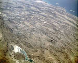
 The Zagros fold and thrust belt in green, with the Zagros Mountains to the right
| |
| Location |
Iran, Iraq, and Turkey Middle East or Western Asia |
| Geology | |
| Age of rock | Carboniferous |
| Mountain type | Fold and thrust belt |
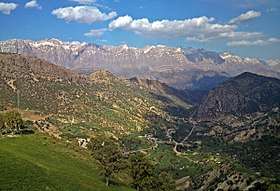
The Zagros Mountains (Persian: کوههای زاگرس; Kurdish: چیاکانی زاگرۆس) are a long mountain range in Iran, Iraq and southeastern Turkey. This mountain range has a total length of 1,600 km (990 mi). The Zagros mountain range begins in northwestern Iran and roughly follows Iran's western border, while covering much of southeastern Turkey and northeastern Iraq. From this border region, the range roughly follows Iran's coast on the Persian Gulf. It spans the whole length of the western and southwestern Iranian plateau, ending at the Strait of Hormuz. The highest point is Mount Zardkuh, at 4,548 metres (14,921 ft).
Geology
The Zagros fold and thrust belt was formed by the collision of two tectonic plates, the Eurasian Plate and the Arabian Plate.[3] This collision primarily happened during the Miocene and folded the entire rocks that had been deposited from the Carboniferous to the Miocene in the geosyncline in front of the Iranian Plate. The process of collision continues to the present and as the Arabian Plate is being pushed against the Eurasian Plate, the Zagros Mountains and the Iranian Plateau are getting higher and higher. Recent GPS measurements in Iran[4] have shown that this collision is still active and the resulting deformation is distributed non-uniformly in the country, mainly taken up in the major mountain belts like Alborz and Zagros. A relatively dense GPS network which covered the Iranian Zagros[5] also proves a high rate of deformation within the Zagros. The GPS results show that the current rate of shortening in the southeast Zagros is ~10 mm/a (0.39 in/year), dropping to ~5 mm/a (0.20 in/year) in the northwest Zagros. The north-south Kazerun strike-slip fault divides the Zagros into two distinct zones of deformation. The GPS results also show different shortening directions along the belt, normal shortening in the southeast and oblique shortening in the northwest Zagros. The Zagros mountains were created around the time of the second ice age, which was the reason for the crashing of the tectonic plates, leading to it's uniqueness.
The sedimentary cover in the SE Zagros is deforming above a layer of rock salt (acting as a ductile decollement with a low basal friction) whereas in the NW Zagros the salt layer is missing or is very thin. This different basal friction is partly responsible for the different topographies on either side of the Kazerun fault. Higher topography and narrower zone of deformation in the NW Zagros is observed whereas in the SE, deformation was spread more and a wider zone of deformation with lower topography was formed.[6] Stresses induced in the Earth's crust by the collision caused extensive folding of the preexisting layered sedimentary rocks. Subsequent erosion removed softer rocks, such as mudstone (rock formed by consolidated mud) and siltstone (a slightly coarser-grained mudstone) while leaving harder rocks, such as limestone (calcium-rich rock consisting of the remains of marine organisms) and dolomite (rocks similar to limestone containing calcium and magnesium). This differential erosion formed the linear ridges of the Zagros Mountains. The depositional environment and tectonic history of the rocks were conducive to the formation and trapping of petroleum, and the Zagros region is an important area for oil production. Salt domes and salt glaciers are a common feature of the Zagros Mountains. Salt domes are an important target for petroleum exploration, as the impermeable salt frequently traps petroleum beneath other rock layers.
Type and age of rock
The mountains have a totally sedimentary origin and are made primarily of limestone. In the Elevated Zagros or the Higher Zagros, the Paleozoic rocks could be found mainly in the upper and higher sections of the peaks of the Zagros Mountains along the Zagros main fault. On both sides of this fault, there are Mesozoic rocks, a combination of Triassic and Jurassic rocks that are surrounded by Cretaceous rocks on both sides. The Folded Zagros (the mountains south of the Elevated Zagros and almost parallel to the main Zagros fault) is formed mainly of Tertiary rocks, with the Paleogene rocks south of the Cretaceous rocks and then the Neogene rocks south of the Paleogene rocks. The mountains are divided into many parallel sub-ranges (up to 10 or 250 km (6.2 or 155.3 mi) wide), and orogenically have the same age as the Alps. Iran's main oilfields lie in the western central foothills of the Zagros mountain range. The southern ranges of the Fars Province have somewhat lower summits, reaching 4,000 metres (2.5 miles). They contain some limestone rocks showing abundant marine fossils.[6]
History
Signs of early agriculture date back as far as 9000 BC to the foothills of the mountains.[7] There were settlements that later grew into cities, eventually named Anshan and Susa. Jarmo is one archaeological site in this area. Shanidar, where the ancient skeletal remains of Neanderthals have been found, is another. Some of the earliest evidence of wine production has been discovered in the mountains; both the settlements of Hajji Firuz Tepe and Godin Tepe have given evidence of wine storage dating between 3500 and 5400 BC.[8]
During early ancient times, the Zagros was the home of peoples such as the Kassites, Guti, Elamites and Mitanni, who periodically invaded the Sumerian and/or Akkadian cities of Mesopotamia. The mountains create a geographic barrier between the Mesopotamian Plain, which is in Iraq, and the Iranian Plateau. A small archive of clay tablets detailing the complex interactions of these groups in the early second millennium BC has been found at Tell Shemshara along the Little Zab.[9] Tell Bazmusian, near Shemshara, was occupied between 5000 BCE and 800 CE, although not continuously.[10]
Climate
The mountains contain several ecosystems. Prominent among them are the forest and forest steppe areas with a semi-arid climate. As defined by the World Wildlife Fund and used in their Wildfinder, the particular terrestrial ecoregion of the mid to high mountain area is Zagros Mountains forest steppe (PA0446). The annual precipitation ranges from 400–800 mm (16–31 in) and falls mostly in winter and spring. Winters are severe, with low temperatures often below −25 °C (−13 °F). The region exemplifies the continental variation of the Mediterranean climate pattern, with a snowy winter and mild, rainy spring, followed by a dry summer and autumn.[11]
| Climate data for Amadiya District, Iraq | |||||||||||||
|---|---|---|---|---|---|---|---|---|---|---|---|---|---|
| Month | Jan | Feb | Mar | Apr | May | Jun | Jul | Aug | Sep | Oct | Nov | Dec | Year |
| Average high °C (°F) | −0.2 (31.6) |
1.4 (34.5) |
6.4 (43.5) |
12.2 (54) |
19.3 (66.7) |
24.8 (76.6) |
29.7 (85.5) |
29.6 (85.3) |
25.6 (78.1) |
17.7 (63.9) |
9.7 (49.5) |
2.7 (36.9) |
14.9 (58.8) |
| Average low °C (°F) | −8.0 (17.6) |
−6.8 (19.8) |
−2.0 (28.4) |
3.5 (38.3) |
8.8 (47.8) |
13.0 (55.4) |
17.3 (63.1) |
16.9 (62.4) |
13.0 (55.4) |
7.2 (45) |
2.1 (35.8) |
−4.3 (24.3) |
5.1 (41.1) |
| Source: [12] | |||||||||||||
Glaciation
The mountains of the East-Zagros, the Kuh-i-Jupar (4,135 m (13,566 ft)), Kuh-i-Lalezar (4,374 m (14,350 ft)) and Kuh-i-Hezar (4,469 m (14,662 ft)) do not currently have glaciers. Only at Zard Kuh and Dena some glaciers still survive. However, before the Last Glacial Period they had been glaciated to a depth in excess of 1,900 metres (1.2 miles), and during the Last Glacial Period to a depth in excess of 2,160 metres (7,090 feet). Evidence exists of a 20 km (12 mi) wide glacier fed along a 17 km (11 mi) long valley dropping approximately 1,600 m (5,200 ft) along its length on the north side of Kuh-i-Jupar with a thickness of 350–550 m (1,150–1,800 ft). Under precipitation conditions comparable to the current conditions, this size of glacier could be expected to form where the annual average temperature was between 10.5 and 11.2 °C (50.9 and 52.2 °F), but since conditions are expected to have been dryer during the period in which this glacier was formed, the temperature must have been lower.[13][14][15][16]
Flora and fauna
.JPG)
Although currently degraded through overgrazing and deforestation, the Zagros region is home to a rich and complex flora. Remnants of the originally widespread oak-dominated woodland can still be found, as can the park-like pistachio/almond steppelands. The ancestors of many familiar foods, including wheat, barley, lentil, almond, walnut, pistachio, apricot, plum, pomegranate and grape can be found growing wild throughout the mountains.[18] Persian oak (Quercus brantii) (covering more than 50% of the Zagros forest area) is the most important tree species of the Zagros in Iran.[19]
Other floral endemics found within the mountain range include: Allium iranicum, Astracantha crenophila, Bellevalia kurdistanica, Cousinia carduchorum, Cousinia odontolepis, Echinops rectangularis, Erysimum boissieri, Iris barnumae, Ornithogalum iraqense, Scrophularia atroglandulosa, Scorzoner kurdistanica, Tragopogon rechingeri, and Tulipa kurdica.[20]
The Zagros are home to many threatened or endangered organisms, including the Zagros Mountains mouse-like hamster (Calomyscus bailwardi), the Basra reed-warbler (Acrocephalus griseldis) and the striped hyena (Hyena hyena). Luristan newt (Neurergus kaiseri) - vulnerable endemic to the central Zagros mountains of Iran. The Persian fallow deer (Dama dama mesopotamica), an ancient domesticate once thought extinct, was rediscovered in the late 20th century in Khuzestan Province, in the southern Zagros.
In the late 19th century, the Asiatic lion (Panthera leo leo)[21] inhabited the southwestern part of the mountains. It is now extinct in this region.[22]
Gallery
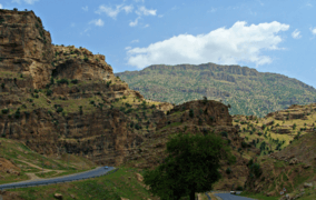 A road through the mountains in Iraqi Kurdistan
 Mount Oshtorankuh
See also
References
- 1 2 "Zagros Mountains". Brittanica. Encyclopedia Brittanica. Retrieved 17 August 2017.
- ↑ "Salt Dome in the Zagros Mountains, Iran". NASA Earth Observatory. Retrieved 2006-04-27.
- ↑ Scheffel, Richard L.; Wernet, Susan J., eds. (1980). Natural Wonders of the World. United States of America: Reader's Digest Association, Inc. pp. 422–423. ISBN 0-89577-087-3.
- ↑ Nilforoushan F., Masson F., Vernant P., Vigny C., Martinod J., Abbassi M., Nankali H., Hatzfeld D., Bayer R., Tavakoli F., Ashtiani A., Doerflinger E., Daignières M., Collard P., Chéry J., 2003. GPS network monitors the Arabia-Eurasia collision deformation in Iran, Journal of Geodesy, 77, 411–422.
- ↑ Hessami K., Nilforoushan F., Talbot CJ., 2006, Active deformation within the Zagros Mountains deduced from GPS measurements, Journal of the Geological Society, London, 163, 143–148.
- 1 2 Nilforoushan F, Koyi HA., Swantesson J.O.H., Talbot CJ., 2008, Effect of basal friction on the surface and volumetric strain in models of convergent settings measured by laser scanner, Journal of Structural Geology, 30, 366–379.
- ↑ La Mediterranée, Braudel, Fernand, 1985, Flammarion, Paris
- ↑ Phillips, Rod. A Short History of Wine. New York: Harper Collins. 2000.
- ↑ Eidem, Jesper; Læssøe, Jørgen (2001), The Shemshara archives 1. The letters, Historisk-Filosofiske Skrifter, 23, Copenhagen: Kongelige Danske videnskabernes selskab, ISBN 87-7876-245-6
- ↑ Al-Soof, Behnam Abu (1970). "Mounds in the Rania Plain and excavations at Tell Bazmusian (1956)". Sumer. 26: 65–104. ISSN 0081-9271.
- ↑ Frey, W.; W. Probst (1986). Kurschner, Harald, ed. "A synopsis of the vegetation in Iran". Contributions to the vegetation of Southwest Asia. Wiesbaden, Germany: L. Reichert: 9–43. ISBN 3-88226-297-4.
- ↑ "Climate statistics for Amadiya". Meteovista. Retrieved September 6, 2014.
- ↑ Kuhle, M. (1974):Vorläufige Ausführungen morphologischer Feldarbeitsergebnisse aus den SE-Iranischen Hochgebirgen am Beispiel des Kuh-i-Jupar. Zeitschrift für Geomorphologie N.F., 18, (4), pp. 472-483.
- ↑ Kuhle, M. (1976):Beiträge zur Quartärgeomorphologie SE-Iranischer Hochgebirge. Die quartäre Vergletscherung des Kuh-i-Jupar. Göttinger Geographische Abhandlungen, 67, Vol. I, pp. 1-209; Vol. II, pp. 1-105.
- ↑ Kuhle, M. (2007):The Pleistocene Glaciation (LGP and pre-LGP, pre-LGM) of SE-Iranian Mountains exemplified by the Kuh-i-Jupar, Kuh-i-Lalezar and Kuh-i-Hezar Massifs in the Zagros. Polarforschung, 77, (2-3), pp. 71-88. (Erratum/ Clarification concerning Figure 15, Vol. 78, (1-2), 2008, p. 83.
- ↑ Elsevier: Ehlers,. "Quaternary Glaciations - Extent and Chronology Volume 15: A closer look Welcome". booksite.elsevier.com.
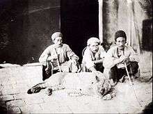
- ↑ Sevruguin, A. (1880). "Men with live lion". National Museum of Ethnology in Leiden, The Netherlands; Stephen Arpee Collection. Retrieved 2018-03-26.
- ↑ Cowan, edited by C. Wesley; Nancy L. Benco; Patty Jo Watson (2006). The origins of agriculture : an international perspective ([New ed.]. ed.). Tuscaloosa, Ala.: University of Alabama Press. ISBN 0-8173-5349-6. Retrieved 5 May 2012.
- ↑ M. Heydari; H. Poorbabaei; T. Rostami; M. Begim Faghir; A. Salehi; R. Ostad Hashmei (2013). "Plant species in Oak (Quercus brantii Lindl.) understory and their relationship with physical and chemical propertiesof soil in different altitude classes in the Arghvan valley protected area, Iran" (PDF). Caspian Journal of Environmental Sciences, 2013, Vol. 11 No.1, pp. 97~110. Archived from the original (PDF) on 3 April 2015. Retrieved 10 April 2014.
- ↑ "Haji Omran Mountain (IQ018)" (PDF). natrueiraq.org. Retrieved 22 June 2016.
- ↑ Kitchener, A. C.; Breitenmoser-Würsten, C.; Eizirik, E.; Gentry, A.; Werdelin, L.; Wilting A.; Yamaguchi, N.; Abramov, A. V.; Christiansen, P.; Driscoll, C.; Duckworth, J. W.; Johnson, W.; Luo, S.-J.; Meijaard, E.; O’Donoghue, P.; Sanderson, J.; Seymour, K.; Bruford, M.; Groves, C.; Hoffmann, M.; Nowell, K.; Timmons, Z.; Tobe, S. (2017). "A revised taxonomy of the Felidae: The final report of the Cat Classification Task Force of the IUCN Cat Specialist Group" (PDF). Cat News. Special Issue 11.
- ↑ Heptner, V. G.; Sludskij, A. A. (1992) [1972]. "Lion". Mlekopitajuščie Sovetskogo Soiuza. Moskva: Vysšaia Škola [Mammals of the Soviet Union. Volume II, Part 2. Carnivora (Hyaenas and Cats)]. Washington DC: Smithsonian Institution and the National Science Foundation. pp. 82–95. ISBN 90-04-08876-8.
External links
| Wikimedia Commons has media related to Zagros Mountains. |
- Zagros, Photos from Iran, Livius.
- The genus Dionysia
- Iran, Timeline of Art History
- Mesopotamia 9000–500 B.C.
- Major Peaks of the Zagros Mountains
| History |
|  | ||||||
|---|---|---|---|---|---|---|---|---|
| Geography | ||||||||
| Politics | ||||||||
| Economy | ||||||||
| Society |
| |||||||
33°40′00″N 47°00′00″E / 33.66667°N 47.00000°ECoordinates: 33°40′00″N 47°00′00″E / 33.66667°N 47.00000°E