Pir Panjal Range
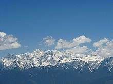
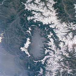
The Pir Panjal Range (Kashmiri: Pīr Pantsāl Range) is a group of mountains in the Inner Himalayan region, running from east-southeast (ESE) to west-northwest (WNW) across the Indian states of Himachal Pradesh and Jammu and Kashmir where the average elevation varies from 1,400 m (4,600 ft) to 4,100 m (13,500 ft).[1] The Himalayas show a gradual elevation towards the Dhauldhar and Pir Panjal ranges. Pir Panjal is the largest range of the lower Himalayas. Near the bank of the Sutlej river, it dissociates itself from the Himalayas and forms a divide between the rivers Beas and Ravi on one side and the Chenab on the other. The famous Galyat mountains are also located in this range.
Etymology
The Pir Panjal range is named after the Pir Panjal Pass, whose original name as recorded by Srivara, is Panchaladeva (IAST: Pāñcāladeva, meaning the deity of Panchala). Panchala is a country mentioned in the Mahabharata in the northwest Uttar Pradesh. However, there are also traditions that place the Mahabharata regions in western Punjab and southern Kashmir. Scholar Dineshchandra Sircar has analysed the geography described in the Shakti‐sangama Tantra, where this is indeed the case.[2] Scholar M. A. Stein believes that the concept of deity must have been translated into that of a Pir after the region was Islamised.[3]
Peaks
Deo Tibba (6,001 m (19,688 ft)) and Indrasan (6,221 m (20,410 ft)) are two important peaks at the eastern end of the mountain range. They can be approached from both the Parvati-Beas Valley (Kulu District) and the Chandra (Upper Chenab) Valley (Lahaul and Spiti District) in Himachal Pradesh. The hill station of Gulmarg in Kashmir lies in this range.[4]
Passes
 |
| Passes of the Pir Panjal Range |
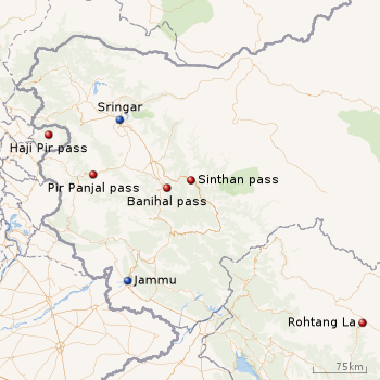
Haji Pir Pass (altitude 2,637 m (8,652 ft)) on the western Pir Panjal range on the road between Poonch and Uri is in the area of Kashmir administered by Pakistan.
The Pir Panjal Pass (also called Pir ki Gali) connects the Kashmir valley with Rajouri and Poonch via the 'Mughal Road'. It is the highest point of Mughal road at 3,490 m (11,450 ft) and lies to the south west of the Kashmir valley.[5] The nearest town to the pass in the Kashmir valley is Shopian, the apple town.
The Banihal pass (2,832 m (9,291 ft)) lies at the head of the river Jhelum at the southern end of the Kashmir valley. Banihal and Qazigund lie on either side of the pass.
The Sinthan pass connects Jammu and Kashmir with Kishtwar.
Rohtang La (altitude 3,978 m (13,051 ft)) is a mountain pass on the eastern Pir Panjal range connecting Manali in the Kullu Valley to Keylong in the Lahaul Valley.
Tunnels
Jawahar Tunnel
The Jawahar Tunnel is a 2.5 km (1.6 mi) long tunnel through Pir Panjal mountain under the Banihal pass connects Banihal with Qazigund on the other side of the mountain. The Jawahar Tunnel was named after the first Prime Minister of India was constructed in early 1950s and commissioned in December 1956 to ensure snow-free passage throughout the year. It is at elevation of about 2,100 m (6,900 ft). It was designed for 150 vehicles per day but now used by more than 7,000 vehicles per day.[6] Therefore, a new wider and longer tunnel has been planned at a lower elevation.
Banihal Qazigund Road Tunnel
Construction of a new 8.45 km (5.25 mi) long twin-tube Banihal Qazigund Road Tunnel started in 2011. The new tunnel is at a lower elevation than the existing Jawahar tunnel and, when completed, would reduce the road distance between Banihal and Qazigund by 16 km (9.9 mi). It would also be less prone to snow avalanche as it will be at a lower elevation.[7]
Rohtang Tunnel
The Rohtang Tunnel is being built under the Rohtang Pass in the eastern Pir Panjal range of the Himalayas on the Leh-Manali Highway. With 8.8 km (5.5 mi) length, the tunnel will be the second longest road tunnel in India and is expected to reduce the distance between Manali and Keylong by about 60 km (37 mi). The tunnel is at 3,100 metres (10,171 ft) elevation whereas the Rohtang pass is at 3,978 metres (13,051 ft) elevation. Lying on the Manali-Leh axis, this is one of the two routes to Ladakh..
Banihal Railway Tunnel
The Pir Panjal Railway Tunnel, an 11.215 kilometres (6.969 mi) railway tunnel, passes through the Pir Panjal Range in Jammu and Kashmir. It connects Quazigund and Banihal and is a part of the Udhampur-Srinagar-Baramulla railway project. The tunnel was commissioned on 26 June 2013 for regular service. It is India's longest and Asia's fourth longest railway tunnel.[8]
See also
References
- ↑ "Home ministry chalks out plan to settle Kashmiri Pandits".
- ↑ Sircar, Dineschandra (1971), Studies in the Geography of Ancient and Medieval India, Motilal Banarsidass Publ., pp. 204–205, ISBN 978-81-208-0690-0
- ↑ Stein, M. A. (1900), Kalhana's Rajatarangini: A chronicle of the kings of Kasmir, Volume 2, Westminster: Archibald Constable and Co., pp. 397–398, ISBN 978-81-208-0370-1
- ↑ Pir Panjal Range (mountain system, Asia) – Britannica Online Encyclopedia
- ↑ Kapadia, Harish (1999), Across Peaks & Passes in Ladakh, Zanskar & East Karakoram, Indus Publishing, p. 23, ISBN 978-81-7387-100-9
- ↑ Beacon Light in the Tunnel Archived 1 September 2012 at the Wayback Machine.
- ↑ "Passages of employment to Srinagar's denizens".
- ↑ "India's longest railway tunnel unveiled in Jammu & Kashmir". The Times of India. 14 October 2011.
Further reading
- Jreat, Manoj (2004), Tourism in Himachal Pradesh, Indus Publishing, pp. 15–, ISBN 978-81-7387-157-3
- Minhas, Poonam (1998), Traditional Trade & Trading Centres in Himachal Pradesh: With Trade-routes and Trading Communities, Indus Publishing, pp. 28–, ISBN 978-81-7387-080-4
Coordinates: 33°53′36″N 74°29′19″E / 33.89333°N 74.48861°E