Banda Sea
| Banda Sea | |
|---|---|
.jpg) Run (left) and Nailaka (right), islands in the Banda Sea | |
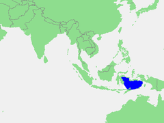 Location of the Banda Sea in Southeast Asia | |
| Type | Sea |
| Primary outflows | Pacific Ocean, Timor Sea, Molucca Sea, Ceram Sea |
| Max. length | 1,000 km (620 mi) |
| Max. width | 500 km (310 mi) |
The Banda Sea is a sea in the Maluku Islands of Indonesia, connected to the Pacific Ocean but surrounded by hundreds of islands, as well as the Halmahera and Ceram Seas. It is about 1000 km (600 mi) east to west, and about 500 km (300 mi) north to south.
Extent
The International Hydrographic Organization (IHO) defines the Banda Sea as being one of the waters of the East Indian Archipelago. The IHO defines its limits as follows:[1]
On the North The Southern limits of the Molukka Sea [sic] and the Western and Southern limits of the Ceram Sea.
On the East. From Tg Borang, the Northern point of Noehoe Tjoet [Kai Besar], through this island to its Southern point, thence a line to the Northeast point of Fordata, through this island and across to the Northeast point of Larat, Tanimbar Islands (7°06′S 131°55′E / 7.100°S 131.917°E), down the East coast of Jamdena [Yamdena] Island to its Southern point, thence through Anggarmasa to the North point of Selaroe and through this island to Tg Aro Oesoe its Southern point (8°21′S 130°45′E / 8.350°S 130.750°E).
On the South. A line from Tanjong Aro Oesoe, through Sermata to Tanjong Njadora the Southeast point of Lakov [Lakor, sic] (8°16′S 128°14′E / 8.267°S 128.233°E) along the South coasts of Lakov [Lakor], Moa and Leti Islands to Tanjong Toet Pateh, the West point of Leti, thence a line to Tanjong Sewirawa the Eastern extremity of Timor and along the North coast as far as longitude 125° East.
On the West. From a point on the North coast of Timor in 125° East up this meridian to Alor Island, thence round the East point and along the North coasts of the Alor, Pantar, Lomblen and Adoenara Islands and thence across the Northern end of Flores Strait to Tanjong Serbete the Eastern extreme of Flores, thence a line from its Northern point (8°04′S 122°52′E / 8.067°S 122.867°E) to Kalaotoa Island (7°24′S 121°52′E / 7.400°S 121.867°E) and through the chain of islands lying between it and the South point of Pulo Salayar, through this island and across the Strait to Tanjong Lassa, Celebes (5°37′S 120°28′E / 5.617°S 120.467°E), thence along the Southern limit of the Gulf of Boni and up the East coast of Celebes to Tanjong Botok (1°04′S 123°19′E / 1.067°S 123.317°E).
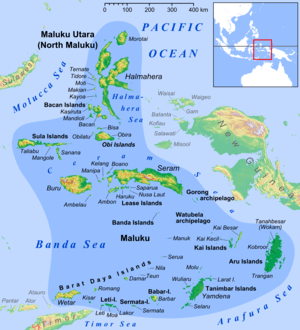
Islands
Islands bordering the Banda Sea include Sulawesi to the west, Buru, Ambon Island, Seram, Aru Islands, Barat Daya Islands, to the Tanimbar Islands, the Kai Islands and Timor in the East. Although the borders of the sea are hazardous to navigation, with many small rocky islands, the middle of the sea is relatively open. Island groups within the sea include the Banda Islands. A number of islands in the Banda Sea are active volcanoes including Gunung Api and Manuk in the Banda Islands.
Plate tectonic activities in Banda Sea
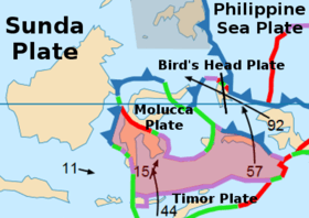
The Banda arc is famous for its 180° curvature and is, in Timor, generally agreed to be the product of collision between a volcanic arc and the Australian continental margin.[2][3] The Banda Sea occupies the main portion of the Banda Sea Plate. The southern margin of the sea consists of island arcs above subduction zones. To the east of the Sunda Trench is the Timor Trough which lies south of Timor, the Tanimbar Trough south of the Tanimbar Islands and the Aru Trough east of the Aru Islands. These trenches are the subduction zone of the Indo-Australian plate beneath the Banda Sea Plate, where the Indo-Australian Plate moves northwards. Fore-arc sediments progressively carried northwards by the Indo-Australian Plate have been folded and faulted forming Timor island. To the northeast lies Seram Island which overlies the subduction of the Bird's Head Plate of West Papua.[4]
Earthquakes
Earthquakes are very frequent in the area, due to the confluence of three tectonic plates - Eurasian, Pacific and Indo-Australian plates.
Ecology
The Banda Islands, Tanimbar Islands, Kai Islands and other smaller islands in the Banda Sea have been designated as the Banda Sea Islands moist deciduous forests ecoregion, the eastern end of the Wallacea biogeographical region containing a mixture of plant and animal species from both Asia and Australasia. These islands are covered in mostly intact rain forest and home to a number of endemic plants and animals including twenty-one birds, a very high number for this small ecoregion. There are only twenty-two mammals on these islands including three endemics, the rare dusky pademelon (Thylogale brunii) and tomb bat (Taphozous achates), and an endangered mouse-eared bat, the Kei myotis (Myotis stalkeri). The birdlife is threatened by egg collectors and even more by cats and rodents that have been introduced to the islands. Yamdena in the Tanimbar Islands is an example of a large and fairly unspoilt habitat and is a protected area.[5] The base for visiting these islands is by plane or ship from Ambon Island to the north, the largest of the Maluku Islands. The Banda and Kei Islands, although remote, are visited by tourists for snorkelling and for their unspoilt beaches. Various cetacean species have been recorded including either or both blue and pygmy blue whales[6][7][8] and Omura's whales.[9]
References
- ↑ "Limits of Oceans and Seas, 3rd edition" (PDF). International Hydrographic Organization. 1953. Retrieved 7 February 2010.
- ↑ Carter, D. J., Audley-Charles, M. G. & Barber, A. J. Stratigraphical analysis of island arc-continental margin collision in eastern Indonesia. J. Geol. Soc. Lond. 132, 179�189 (1976).
- ↑ Hamilton, W. Tectonics of the Indonesian Region Vol. 1078 (US Geol. Soc. Prof. Pap., 1979).
- ↑ "Chapter II (Geology of Timor-Leste)". Atlas of mineral resources of the ESCAP region Volume 17 Geology and Mineral Resources of Timor-Leste (PDF). United Nations Economic and Social Commission for Asia and the Pacific. 24 December 2003. Archived from the original (PDF) on 20 May 2005.
- ↑ "Banda Sea Islands moist deciduous forests". Terrestrial Ecoregions. World Wildlife Fund.
- ↑ Wildiaries. BLUE WHALES OF THE BANDA SEA & FORGOTTEN ISLANDS. Retrieved on September 24, 2017
- ↑ Edwards J.. An Indo-Pacific Bottlenose Dolphin bow riding on the wake of a gigantic Blue Whale.. Getty Images. Retrieved on September 24, 2017
- ↑ Sarah. 2015. Sailing Through the Banda Sea. Small Girl Big Travels: Field Notes. Retrieved on September 24, 2017
- ↑ Ogata J. M.. 2017. Ambon – Banda Islands – Raja Ampat. Mermaid Liveaboards. Retrieved on September 24, 2017
Further reading
- Ponder, H. W. (1944) In Javanese waters; some sidelights on a few of the countless lovely, little known islands scattered over the Banda sea & some glimpses of their strange & stormy history London, Seeley, Service & Co. ltd.
- Patrick D. Nunn(1994) Oceanic Islands Oxford, Great Britain, Blackwell