Dry Andes
| Dry Andes | |
|---|---|
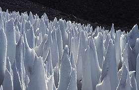 Field of penitentes on the upper Río Blanco, Central Andes of Argentina | |
| Highest point | |
| Peak | Aconcagua |
| Elevation | 6,961 m (22,838 ft) |
| Dimensions | |
| Length | 1,200 km (750 mi) |
| Geography | |
| Country | Chile, Argentina, Bolivia |
| Parent range | Andes |
The Dry Andes (Spanish: Andes áridos) is a climatic and glaciological subregion of the Andes. Together with the Wet Andes it is one of the two subregions of the Argentine and Chilean Andes. The Dry Andes runs from the Atacama Desert in northern Chile and Argentina south to a latitude of 35°S in Chile. In Argentina the Dry Andes reaches 40°S due to the leeward effect of the Andes. According to Luis Lliboutry the Dry Andes can be defined by the distribution of penitentes.[1] The southernmost well developed penitentes are found on Lanín Volcano.
Paleogeography, paleoclimatology and paleoglaciology
Though precipitation increases with the height, there are semiarid conditions in the nearly 7,000 metres (23,000 ft) towering mountains of the Andes. This dry steppe climate is considered to be of the subtropic type at 32-34° S. In the valley bottoms only dwarf scrubs grow. The largest glaciers, e.g. the Plomo glacier and the Horcones glacier, do not reach 10 kilometres (6.2 mi) in length the ice thickness is not very significant. During glacial times however, c. 20,000 years ago, the glaciers were over ten times longer. On the east-side of this section of the Mendoza Andes they flowed down to 2,060 metres (6,760 ft) and on the west-side to c. 1,220 metres (4,000 ft).[2][3] The massifs of Cerro Aconcagua 6,962 metres (22,841 ft), Cerro Tupungato 6,550 metres (21,490 ft) and Nevado Juncal 6,110 metres (20,050 ft) are situated deca-kilometres away from each other and were connected by a joint ice stream network. Its dendritic glacier arms, i.e. components of valley glaciers, were up to 112.5 kilometres (69.9 mi) long, over 1,250 metres (4,100 ft) thick and spanned a vertical distance of 5,150 metres (16,900 ft). The climatic glacier snowline (ELA) was lowered from the current 4,600 metres (15,100 ft) to 3,200 metres (10,500 ft) during glacial times.[4][5][6][7][8][9][10][11][12]
References
- ↑ "Glaciers of the Dry Andes". Louis Lliboutry, USGS. Retrieved 2008-12-21.
- ↑ Kuhle, M. (2011): The High-Glacial (Last Glacial Maximum) Glacier Cover of the Aconcagua Group and Adjacent Massifs in the Mendoza Andes (South America) with a Closer Look at Further Empirical Evidence. Development in Quaternary Science, Vol. 15 (Quaternary Glaciation - Extent and Chronology, A Closer Look, Eds: Ehlers, J.; Gibbard, P.L.; Hughes, P.D.), 735-738. (Elsevier B.V., Amsterdam).
- ↑ Brüggen, J. (1929): Zur Glazialgeologie der chilenischen Anden. Geol. Rundsch. 20, 1–35, Berlin.
- ↑ Kuhle, M. (1984): Spuren hocheiszeitlicher Gletscherbedeckung in der Aconcagua-Gruppe (32-33° S). In: Zentralblatt für Geologie und Paläontologie Teil 1 11/12, Verhandlungsblatt des Südamerika-Symposiums 1984 in Bamberg: 1635-1646.
- ↑ Kuhle, M. (1986): Die Vergletscherung Tibets und die Entstehung von Eiszeiten. In: Spektrum der Wissenschaft 9/86: 42-54.
- ↑ Kuhle, M. (1987): Subtropical Mountain- and Highland-Glaciation as Ice Age Triggers and the Waning of the Glacial Periods in the Pleistocene. In: GeoJournal 14 (4); Kluwer, Dordrecht/ Boston/ London: 393-421.
- ↑ Kuhle, M. (1988): Subtropical Mountain- and Highland-Glaciation as Ice Age Triggers and the Waning of the Glacial Periods in the Pleistocene. In: Chinese Translation Bulletin of Glaciology and Geocryology 5 (4): 1-17 (in Chinese language).
- ↑ Kuhle, M. (1989): Ice-Marginal Ramps: An Indicator of Semiarid Piedmont Glaciations. In: GeoJournal 18; Kluwer, Dordrecht/ Boston/ London: 223-238.
- ↑ Kuhle, M. (1990): Ice Marginal Ramps and Alluvial Fans in Semi-Arid Mountains: Convergence and Difference. In: Rachocki, A.H., Church, M. (eds.): Alluvial fans - A field approach. John Wiley & Sons Ltd, Chester-New York-Brisbane-Toronto-Singapore: 55-68.
- ↑ Kuhle, M. (1990): The Probability of Proof in Geomorphology - an Example of the Application of Information Theory to a New Kind of Glacigenic Morphological Type, the Ice-marginal Ramp (Bortensander). In: GeoJournal 21 (3); Kluwer, Dordrecht/ Boston/ London: 195-222.
- ↑ Kuhle, M. (2004): The Last Glacial Maximum (LGM) glacier cover of the Aconcagua group and adjacent massifs in the Mendoza Andes (South America). In: Ehlers, J., Gibbard, P.L. (Eds.), Quaternary Glaciation— Extent and Chronology. Part III: South America, Asia, Africa, Australia, Antarctica. Development in Quaternary Science, vol. 2c. Elsevier B.V., Amsterdam, pp. 75–81.
- ↑ Kuhle, M. (2011): The High-Glacial (Last Glacial Maximum) Glacier Cover of the Aconcagua Group and Adjacent Massifs in the Mendoza Andes (South America) with a Closer Look at Further Empirical Evidence. Development in Quaternary Science, Vol. 15 (Quaternary Glaciation - Extent and Chronology, A Closer Look, Eds: Ehlers, J.; Gibbard, P.L.; Hughes, P.D.), 735-738. (Elsevier B.V., Amsterdam).