Labrador Peninsula
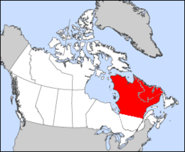 Map of the Labrador Peninsula, with borders delineated based on watershed boundaries. | |
| Continent | North America |
|---|---|
| Region | Eastern Canada |
| Area | |
| • Total | 1,400,000 km2 (540,000 sq mi) |
| • Land | 88% |
| • Water | 12% |
| Highest point | Mount Caubvick |
| Lowest point | Sea level |
| Longest river | La Grande River |
| Largest lake | Caniapiscau Reservoir |
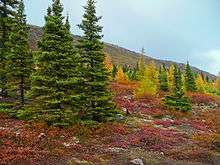
| Climate | Largely subarctic |
| Terrain | Flat and rolling except in the Torngat, Otish and Laurentian mountain ranges. |
The Labrador Peninsula is a large peninsula in eastern Canada. It is bounded by the Hudson Bay to the west, the Hudson Strait to the north, the Labrador Sea to the east, and the Gulf of Saint Lawrence to the southeast. The peninsula includes the region of Labrador, which is part of the province of Newfoundland and Labrador, and the regions of Saguenay–Lac-Saint-Jean, Côte-Nord, and Nord-du-Québec, which are in the province of Quebec. It has an area of 1,400,000 km2 (541,000 sq mi).
Location and geography
The peninsula is surrounded by sea on all sides except for the southwest where it connects to the mainland. The northwestern part of the Labrador Peninsula is shaped as a lesser peninsula, the Ungava Peninsula, surrounded by Hudson Bay, the Hudson Strait, and Ungava Bay. The northernmost point of the Ungava Peninsula, Cape Wolstenholme, also serves as the northernmost point of the Labrador Peninsula and of the province of Quebec.
The peninsula is a plateau threaded by river valleys. There are several mountain ranges. The Torngat Mountains, located in the northern part of the peninsula, contain the highest point of the peninsula Mount Caubvick, which at 1,652 metres (5,420 ft) is also the highest point of mainland Canada east of Alberta. The mountains also host Torngat Mountains National Park, the only national park of Canada on the Labrador Peninsula. The park is located in the province of Newfoundland and Labrador, whereas the adjacent Kuururjuaq National Park is located in the province of Quebec.
Hydrology
Due do it being covered almost entirely by the Canadian Shield - a vast, rocky plateau with a history of glaciation - the peninsula has a large number of lakes. The province of Quebec alone has more than half a million [1] lakes of varying size. The largest body of water on the Labrador Peninsula is the Caniapiscau Reservoir, but the largest natural lake is Lake Mistassini. Other lakes of note include the Manicouagan Reservoir, the Smallwood Reservoir, the Caniapiscau Reservoir, and the La Grande 2 and La Grande 3 reservoirs. Due to a history of hydroelectic development, the majority of the larger freshwater lakes on the peninsula are reservoirs.
In addition to an abundance of lakes, the peninsula also has many rivers. The longest, the La Grande River, is 900 kilometres (560 mi) long and flows westwards across nearly half the peninsula. Other rivers of note include the Eastmain River, Rupert River, and Churchill River
History
Prior to European arrival, the peninsula was inhabited chiefly by Cree people, as well as the Innu people in the Southeast area of the peninsula, who referred to their land as Nitassinan, meaning "our land" in the Innu language.[2] The area was known as Markland in Greenlandic Norse and its inhabitants were known as skrælingjar.
It is widely accepted that the peninsula is named after Portuguese explorer João Fernandes Lavrador. He was granted a patent by King Manuel I of Portugal in 1499 which gave him the right to explore that part of the Atlantic Ocean as set out in the Treaty of Tordesillas.
Together with Pêro de Barcelos, he first sighted Labrador in 1498. Fernandes charted the coasts of Southwestern Greenland and of adjacent Northeastern North America around 1498 and gave notice of them in Portugal and Europe. His landowner status allowed him to use the title lavrador, Portuguese for "farmer" or "landholder", while "labrador" in Spanish and Galician means "agricultural worker". (Portuguese pronunciation: [lɐvɾɐˈðoɾ]). Fernandes actually gave the name of Terra do Lavrador to Greenland which was the first land he sighted, but eventually the name was spread to all areas and finally was set for Labrador.[3]
References
- ↑ http://www.mddelcc.gouv.qc.ca/eau/politique/politique-integral.pdf
- ↑ Nitassinan: The Innu Struggle to Reclaim Their Homeland, Douglas & McIntyre, December 1991, 240pp, by Marie Wadden, ISBN 978-1-55365-731-6, (book link), (retrieved 11/19/2012)
- ↑ "The Portuguese Explorers". Memorial University of Newfoundland. Retrieved 24 October 2011.