Judea
Coordinates: 31°41′56″N 35°18′23″E / 31.69889°N 35.30639°E

Judea or Judæa (/dʒuːˈdiːə/;[1] from Hebrew: יהודה, Standard Yəhuda, Tiberian Yəhûḏāh, Greek: Ἰουδαία, Ioudaía; Latin: Iūdaea, Arabic: يهودا, Yahudia) is the ancient Hebrew and Israelite biblical, the exonymic Roman/English, and the modern-day name of the mountainous southern part of the region of Palestine. The name originates from the Hebrew name "Yehudah", a son of the Jewish patriarch Jacob/Israel, and Yehudah's progeny forming the biblical Israelite tribe of Judah (Yehudah) and later the associated Kingdom of Judah, which the 1906 Jewish Encyclopedia dates from 934 until 586 BCE.[2] The name of the region continued to be incorporated through the Babylonian conquest, Persian, Hellenistic, and Roman periods as Yehud, Yehud Medinata, Hasmonean Judea, and consequently Herodian Judea and Roman Judea, respectively.
As a consequence of the Bar Kokhba revolt, in 135 CE the region was renamed and merged with Roman Syria to form Syria Palaestina by the victorious Roman Emperor Hadrian. A large part of Judea was included in Jordanian West Bank between 1948 and 1967 (i.e., the "West Bank" of the Kingdom of Jordan).[3][4] The term Judea as a geographical term was revived by the Israeli government in the 20th century as part of the Israeli administrative district name Judea and Samaria Area for the territory generally referred to as the West Bank.[5]
Etymology
The name Judea is a Greek and Roman adaptation of the name "Judah", which originally encompassed the territory of the Israelite tribe of that name and later of the ancient Kingdom of Judah. Nimrud Tablet K.3751, dated c.733 BCE, is the earliest known record of the name Judah (written in Assyrian cuneiform as Yaudaya or KUR.ia-ú-da-a-a).
Judea was sometimes used as the name for the entire region, including parts beyond the river Jordan.[6] In 200 CE Sextus Julius Africanus, cited by Eusebius (Church History 1.7.14), described "Nazara" (Nazareth) as a village in Judea.[7]
"Judea" was a name used by English-speakers for the hilly internal part of Palestine until the Jordanian rule of the area in 1948. For example, the borders of the two states to be established according to the UN's 1947 partition scheme[8] were officially described using the terms "Judea" and "Samaria" and in its reports to the League of Nations Mandatory Committee, as in 1937, the geographical terms employed were "Samaria and Judea".[9] Jordan called the area ad-difa’a al-gharbiya (translated into English as the "West Bank").[10] "Yehuda" is the Hebrew term used for the area in modern Israel since the region was captured and occupied by Israel in 1967.[11]
Historical boundaries


The classical Roman-Jewish historian Josephus wrote (Wars 3.3.5):
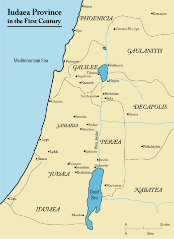
In the limits of Samaria and Judea lies the village Anuath, which is also named Borceos.[12] This is the northern boundary of Judea. The southern parts of Judea, if they be measured lengthways, are bounded by a village adjoining to the confines of Arabia; the Jews that dwell there call it Jordan. However, its breadth is extended from the river Jordan to Joppa. The city Jerusalem is situated in the very middle; on which account some have, with sagacity enough, called that city the Navel of the country. Nor indeed is Judea destitute of such delights as come from the sea, since its maritime places extend as far as Ptolemais: it was parted into eleven portions, of which the royal city Jerusalem was the supreme, and presided over all the neighboring country, as the head does over the body. As to the other cities that were inferior to it, they presided over their several toparchies; Gophna was the second of those cities, and next to that Acrabatta, after them Thamna, and Lydda, and Emmaus, and Pella, and Idumea, and Engaddi, and Herodium, and Jericho; and after them came Jamnia and Joppa, as presiding over the neighboring people; and besides these there was the region of Gamala, and Gaulonitis, and Batanea, and Trachonitis, which are also parts of the kingdom of Agrippa. This [last] country begins at Mount Libanus, and the fountains of Jordan, and reaches breadthways to the lake of Tiberias; and in length is extended from a village called Arpha, as far as Julias. Its inhabitants are a mixture of Jews and Syrians. And thus have I, with all possible brevity, described the country of Judea, and those that lie round about it.[13]
Geography
Judea is a mountainous region, part of which is considered a desert. It varies greatly in height, rising to an altitude of 1,020 m (3,346 ft) in the south at Mount Hebron, 30 km (19 mi) southwest of Jerusalem, and descending to as much as 400 m (1,312 ft) below sea level in the east of the region. It also varies in rainfall, starting with about 400–500 millimetres (16–20 in) in the western hills, rising to 600 millimetres (24 in) around western Jerusalem (in central Judea), falling back to 400 millimetres (16 in) in eastern Jerusalem and dropping to around 100 millimetres (3.9 in) in the eastern parts, due to a rainshadow effect (this is the Judean desert). The climate, accordingly, moves between Mediterranean in the west and desert climate in the east, with a strip of steppe climate in the middle. Major urban areas in the region include Jerusalem, Bethlehem, Gush Etzion, Jericho and Hebron.[14]
Geographers divide Judea into several regions: the Hebron hills, the Jerusalem saddle, the Bethel hills and the Judean desert east of Jerusalem, which descends in a series of steps to the Dead Sea. The hills are distinct for their anticline structure. In ancient times the hills were forested, and the Bible records agriculture and sheep farming being practiced in the area. Animals are still grazed today, with shepherds moving them between the low ground to the hilltops as summer approaches, while the slopes are still layered with centuries-old stone terracing. The Jewish Revolt against the Romans ended in the devastation of vast areas of the Judaean countryside.[15]
Mount Hazor marks the geographical boundary between Samaria to its north and Judea to its south.
History
Early Iron Age

The early history of Judah is uncertain; the Biblical account states that the Kingdom of Judah, along with the Northern Kingdom, was a successor to a united Kingdom of Israel, but modern scholarship generally holds that the united monarchy is ahistorical.[16][17][18][19] Regardless, the Northern Kingdom was conquered into the Neo-Assyrian Empire in 720 BCE. The Kingdom of Judah remained nominally independent, but paid tribute to the Assyrian Empire from 715 and throughout the first half of the 7th century BCE, regaining its independence as the Assyrian Empire declined after 640 BCE, but after 609 again fell under the sway of imperial rule, this time paying tribute at first to the Egyptians and after 601 BCE to the Neo-Babylonian Empire, until 586 BCE, when it was finally conquered by Babylonia.
Judea is central to much of the narrative of the Torah, with the Patriarchs Abraham, Isaac and Jacob said to have been buried at Hebron in the Tomb of the Patriarchs.
Persian and Hellenistic periods
The Babylonian Empire fell to the conquests of Cyrus the Great in 539 BCE.[20] Judea remained under Persian rule until the conquest of Alexander the Great in 332 BCE, eventually falling under the rule of the Hellenistic Seleucid Empire until the revolt of Judas Maccabeus resulted in the Hasmonean dynasty of Kings who ruled in Judea for over a century.[21]
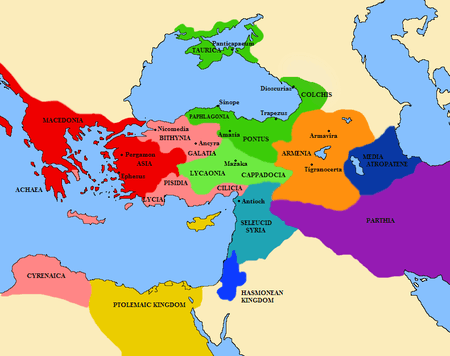
Roman conquest
Judea lost its independence to the Romans in the 1st century BCE, by becoming first a tributary kingdom, then a province, of the Roman Empire. The Romans had allied themselves to the Maccabees and interfered again in 63 BCE, at the end of the Third Mithridatic War, when the proconsul Pompeius Magnus ("Pompey the Great") stayed behind to make the area secure for Rome, including his siege of Jerusalem in 63 BCE. Queen Alexandra Salome had recently died, and a civil war broke out between her sons, Hyrcanus II and Aristobulus II. Pompeius restored Hyrcanus but political rule passed to the Herodian family who ruled as client kings. In 6 CE, Judea came under direct Roman rule as the southern part of the province of Iudaea, although Jews living in the province still maintained some form of independence and could judge offenders by their own laws, including capital offences, until c. 28 CE.[22] The Province of Judea, during the late 2nd Temple period was also divided into five conclaves, or administrative districts: 1) Jerusalem (ירושלם), 2) Gadara (גדרה), 3) Amathus (עמתו), 4) Jericho (יריחו), 5) Sepphoris (צפורין).[23] Eventually, the Jewish population rose against Roman rule in 66 CE in a revolt that was unsuccessful. Jerusalem was besieged in 70 CE and much of the population was killed or enslaved.[24]
Bar Kokhba revolt
Again 70 years later, the Jewish population revolted under the leadership of Simon bar Kokhba and established the last Kingdom of Israel, which lasted three years, before the Romans managed to conquer the province for good, at a high cost in terms of manpower and expense.
After the defeat of Bar Kokhba (132–135 CE) the Roman Emperor Hadrian was determined to wipe out the identity of Israel-Judah-Judea, and renamed it Syria Palaestina. Until that time the area had been called "province of Judea" (Roman Judea) by the Romans.[25] At the same time, he changed the name of the city of Jerusalem to Aelia Capitolina. The Romans killed many Jews and sold many more into slavery; many Jews departed into the Jewish diaspora, but there was never a complete Jewish abandonment of the area, and Jews have been an important (and sometimes persecuted) minority in Judea since that time.[26]
Byzantine period
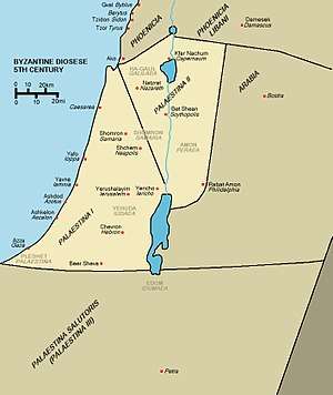
The Byzantines redrew the borders of the Land of Palestine. The various Roman provinces (Syria Palaestina, Samaria, Galilee, and Peraea) were reorganized into three diocese of Palaestina, reverting to the name first used by Greek historian Herodotus in the mid-5th century BCE: Palaestina Prima, Secunda, and Tertia or Salutaris (First, Second, and Third Palestine), part of the Diocese of the East.[27][28] Palaestina Prima consisted of Judea, Samaria, the Paralia, and Peraea with the governor residing in Caesarea. Palaestina Secunda consisted of the Galilee, the lower Jezreel Valley, the regions east of Galilee, and the western part of the former Decapolis with the seat of government at Scythopolis. Palaestina Tertia included the Negev, southern Jordan—once part of Arabia—and most of Sinai with Petra as the usual residence of the governor. Palestina Tertia was also known as Palaestina Salutaris.[27][29] According to historian H.H. Ben-Sasson,[30] this reorganisation took place under Diocletian (284–305), although other scholars suggest this change occurred later in 390.
Timeline
- 11th century BCE–930 BCE — part of the Kingdom of Israel
- 930 BCE–586 BCE — Kingdom of Judah
- 586 BCE–539 BCE — Babylonian Empire
- 539 BCE–332 BCE — Persian Empire
- 332 BCE–305 BCE — Macedonian Empire of Alexander the Great
- 305 BCE–198 BCE — Ptolemaics
- 198 BCE–141 BCE — Seleucids
- 141 BCE–37 BCE — The Hasmonean state in Israel established by the Maccabees, after 63 BCE under Roman supremacy
- 63 BCE — Pompey's conquest of Jerusalem
- 37 BCE–132 CE — Herodian Dynasty ruling Judea as vassal kings under Roman supremacy (37 BCE–4 BCE Herod the Great, 4 BCE–6 CE Herod Archelaus, 41–44 CE Agrippa I), interchanging with direct Roman rule (6–41, 44–132)
- c. 25 BCE — Caesarea Maritima is built by Herod the Great
- 6 CE — Census of Quirinius, too late to correspond to census related to Jesus' birth
- 26–36 — Pontius Pilate prefect of Roman Judea during the Crucifixion of Jesus
- 66–73 — First Jewish–Roman War, includes Destruction of the Second Temple in 70
- 115–117 — Kitos War
- 132–135 — Bar Kokhba's revolt
- 135 — Emperor Hadrian reverts to the name Syria Palaestina first used by Herodotus
See also
References
- ↑ "Book of Mormon Pronunciation Guide". LDS.org. Retrieved 2012-02-25.
- ↑ "Judah, Kingdom of". Jewish Encyclopedia. Retrieved 2014-04-10.
- ↑ Mark A. Tessler (1994). A History of the Israeli-Palestinian Conflict. Indiana University Press. p. 401. ISBN 0-253-20873-4.
- ↑ Bronner, Ethan (2008-12-04). "Israeli Troops Evict Settlers in the West Bank". The New York Times. Retrieved 2018-09-20.
- ↑ Neil Caplan (19 September 2011). The Israel-Palestine Conflict: Contested Histories. John Wiley & Sons. p. 8. ISBN 978-1405175395.
- ↑ Studies in Palestinian Geography, Prof. S.J. Riggs, Auburn Theological Seminary, 1894, JSTOR The Biblical World
- ↑ "A few of the careful, however, having obtained private records of their own, either by remembering the names or by getting them in some other way from the registers, pride themselves on preserving the memory of their noble extraction. Among these are those already mentioned, called Desposyni, on account of their connection with the family of the Saviour. Coming from Nazara and Cochaba, villages of Judea, into other parts of the world, they drew the aforesaid genealogy from memory and from the book of daily records as faithfully as possible." (Eusebius Pamphili, Church History, Book I, Chapter VII,§ 14)
- ↑ "A/RES/181(II) of 29 November 1947". Unispal.un.org. Retrieved 2018-09-20.
- ↑ "Mandate for Palestine - Report of the Mandatory to the LoN (31 December 1937)". Unispal.un.org. Retrieved 2018-09-20.
- ↑ "This Side of the River Jordan; On Language," Philologos, September 22, 2010, Forward.
- ↑ "Judaea". Britannica. Retrieved 2012-12-31.
- ↑ Based on Charles William Wilson's (1836–1905) identification of this site, who thought that Borceos may have been a place about 18 kilometers to the south of Neapolis (Nablus) because of a name similarity (Berkit). See p. 232 in: Wilson, Charles William (1881). Picturesque Palestine, Sinai and Egypt. 1. New York: D. Appleton. . This identification is the result of the equivocal nature of Josephus' statement, where he mentions both "Samaria" and "Judea." Samaria was a sub-district of Judea. Others speculate that Borceos may have referred to the village Burqin, in northern Samaria, and which village marked the bounds of Judea to its north.
- ↑ "Ancient History Sourcebook: Josephus (37 – after 93 CE): Galilee, Samaria, and Judea in the First Century CE". Fordham.edu. Retrieved 2012-12-31.
- ↑ "Picturesque Palestine I: Jerusalem, Judah, Ephraim". Lifeintheholyland.com. Retrieved 2012-12-31.
- ↑ "Unlikely A Tale of Two Conquests: The Unlikely Numismatic Association Between the Fall of New France (AD 1760) and the Fall of Judaea (AD 70)". Ansmagazine.com. Archived from the original on 2012-07-07. Retrieved 2012-12-31.
- ↑ Kuhrt, Amiele (1995). The Ancient Near East. Routledge. p. 438. ISBN 978-0415167628.
- ↑ Finkelstein, Israel, and Silberman, Neil Asher, The Bible Unearthed : Archaeology's New Vision of Ancient Israel and the Origin of Its Sacred Texts, Simon & Schuster, 2002. ISBN 0-684-86912-8
- ↑ "The Bible and Interpretation - David, King of Judah (Not Israel)". Bibleinterp.com. 2014-07-13. Retrieved 2018-09-20.
- ↑ Thompson, Thomas L., 1999, The Bible in History: How Writers Create a Past, Jonathan Cape, London, ISBN 978-0-224-03977-2 p. 207
- ↑ "The Persians". Jewish Virtual Library. Retrieved 2009-06-09.
- ↑ "The Hasmonean Dynasty". Jewish Virtual Library. Retrieved 2009-06-09.
- ↑ Babylonian Talmud, Avodah Zarah 8b; ibid, Sanhedrin 41a
- ↑ Josephus, Antiquities Book 14, chapter 5, verse 4
- ↑ "Roman Rule". Jewish Virtual Library. Retrieved 2009-06-09.
- ↑ "The Name "Palestine"". Jewish Virtual Library. Retrieved 2010-08-16.
- ↑ "Shimon Bar-Kokhba". Jewish Virtual Library. Retrieved 2009-06-09.
- 1 2 Shahin (2005), p. 8
- ↑ Thomas A. Idniopulos (1998). "Weathered by Miracles: A History of Palestine From Bonaparte and Muhammad Ali to Ben-Gurion and the Mufti". The New York Times. Retrieved 2007-08-11.
- ↑ "Roman Arabia". Encyclopædia Britannica. Retrieved 2007-08-11.
- ↑ H.H. Ben-Sasson, A History of the Jewish People, Harvard University Press, 1976, ISBN 0-674-39731-2, p. 351
External links
| Wikimedia Commons has media related to Judea. |
- Judea and civil war
- The subjugation of Judea
- Judaea 6–66 CE
- Judea photos
- The Jewish History Resource Center Project of the Dinur Center for Research in Jewish History, Hebrew University of Jerusalem
| Cities | ||
|---|---|---|
| Regional committee | ||
| Regional councils | ||
| Local councils | ||
| See also | ||