List of islands of Indonesia
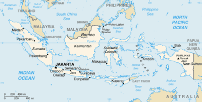
The islands of Indonesia, also known as the Indonesian archipelago and formerly known as the Indian archipelago, may refer either to the islands comprising the nation-state of Indonesia or to the geographical groups which include its islands. According to the Indonesian Coordinating Ministry for Maritime Affairs, of 17,504 officially listed islands within the territory of the Republic of Indonesia, 16,056 island names have been verified by the United Nations Group of Experts on Geographical Names (UNGEGN) as of July 2017.[1]
History
The exact number of islands comprising Indonesia varies among definitions and sources. According to a geospatial survey conducted between 2007 and 2010 by Badan Koordinasi Survei dan Pemetaan Nasional (Bakorsurtanal), the National Coordinating Agency for Survey and Mapping, Indonesia has 13,466 islands.[2] However, according to earlier survey in 2002 by National Institute of Aeronautics and Space (LAPAN), the Indonesian archipelago has 18,307 islands, and according to the CIA World Factbook, there are 17,508 islands.[3] The discrepancy of the numbers of Indonesian islands was because that the earlier surveys include "tidal islands"; sandy cays and rocky reefs that appear during low tide and are submerged during high tide.[4] According to estimates made by the government of Indonesia 8,844 islands have been named, with 922 of those permanently inhabited.[5]
Major islands
- Sunda Islands
- Greater Sunda Islands
- Sumatra, formerly Swarna Dwipa.
- Java, formerly Jawa Dwipa.
- Borneo: divided between the Indonesian region Kalimantan, the country of Brunei and the country of Malaysia's states of Sabah and Sarawak.
- Sulawesi, formerly Celebes.
- Lesser Sunda Islands: the island of Timor divided between Indonesian West Timor and the country of East Timor
- Greater Sunda Islands
- Maluku Islands
- New Guinea: divided between the two Indonesian provinces of Papua and West Papua and the country of Papua New Guinea.
List of islands
The following islands are listed by province:
Java
Banten
Central Java
Special Capital Region of Jakarta
- Thousand Islands (Kepulauan Seribu)
East Java
- Bawean
- Kangean Islands
- Madura
- Raas
- Nusa Barung
- Raja Island
- Sempu Island
West Java
- Pulau Biawak (Monitor Lizard Island), Indramayu
Sumatra
Aceh
199 islands
- Banyak Islands, 99 islands
- Lasia Island
- Simeulue
- Weh
North Sumatra
479 islands
- Batu Islands (formerly Batoe Eilanden), 51 islands
- Berhala on the Strait of Malacca
- Hinako Islands
- Pulau Makole
- Pulau Masa
- Nias Islands
- Samosir, on Lake Toba
- Bukit Lawang
West Sumatra
Bengkulu
- Enggano Island
- Mega Island
Lampung
Riau
- Basu Island
- Bengkalis
- Padang
- Rangsang
- Rupat
- Tebing Tinggi Island
Riau Islands
about 3,200 islands
- Natuna Islands (Kepulauan Natuna)
- Anambas Islands
- Natuna Besar Islands
- South Natuna Islands
- Tambelan Islands
- Riau Archipelago
- Lingga Islands
Bangka-Belitung Islands
Kalimantan
Central Kalimantan
- Damar
- Palau Baning
- Palau Buaya
- Palau Burung
East Kalimantan
- Balabalagan Islands
- Derawan Islands
- ((Balikpapan))
North Kalimantan
South Kalimantan
West Kalimantan
- Bawal
- Galam
- Karimata Islands
- Maya Karimata (Maya)
Sulawesi
Central Sulawesi
- Banggai Islands
- Banggai
- Bowokan Islands (Kepulauan Treko)
- Peleng
- Togian Islands
- Togian *Tolitoli
North Sulawesi
- Bangka
- Bunaken
- Lembeh
- Manado Tua
- Nain
- Sangihe Islands
- Nanipa
- Bukide
- Sangir Besar (Sangir)
- Siau
- Tagulandang
- Talaud Islands
- Kabaruan
- Karakelang
- Salibabu
- Talise
South Sulawesi
Southeast Sulawesi
Lesser Sunda Islands
Bali
East Nusa Tenggara
- Alor Islands, 14 islands + 1 (East Timor)
- Flores
- Babi
- Mules Island
- Komodo
- Gili Lawadarat
- Gili Lawalaut
- Pulau Mangiatan
- Pulau Makasar
- Taka Makasar
- Pulau Mauwang
- Pulau Pararambah
- Pulau Siaba Besar
- Pulau Siaba Kecil
- Pulau Mangiatan
- Pulau Tatawa
- Tukoh Pemaroh
- Pulau Pararambah
- Padar
- Pulau Batubilah
- Pulau Padar Kecil
- Palu'e (Palu)
- Rinca
- Gili Motang
- Golo Mori
- Pulau Muang
- Pulau Rohbong
- Tukoh Gagak
- Tukoh Rohbongkoe
- Pulau Papagaran Besar
- Pulau Papagaran Kecil
- Pulau Batu
- Pulau Mole
- Pulau Pengah Besar
- Pulau Pengah Kecil
- Pulau Batupengah
- Rote Island
- Savu (Sawu)
- Solor Islands
- Sumba
- Timor, divided between Indonesia (West Timor) and the independent nation of East Timor
West Nusa Tenggara
- Gili Air
- Banta Island
- Gili Biaha
- Gili Meno
- Gili Mimpang
- Gili Selang
- Gili Tepekong
- Gili Trawangan
- Lombok
- Medang Island
- Moyo Island
- Pulau Menjangan
- Sangeang
- Satonda
- Sumbawa
Maluku Islands
Maluku
- Aru Islands
- Babar
- Banda
- Barat Daya Islands
- Boano
- Buru
- Gorong archipelago
- Kai Islands
- Kelang
- Leti Islands
- Lakor
- Leti (island)
- Moa
- Manipa
- Nusa Laut
- Seram
- Tanimbar Islands
- Small volcanic islands in Banda Sea
- Tayandu Islands (Kepulauan Tayahad)
- Watubela archipelago
North Maluku
- Bacan
- Erà Islands
- Halmahera, with nearby islands:
- Morotai
- Obi Islands
- Sula islands
- Widi Islands
New Guinea
islands near the Indonesian half of New Guinea island
West Papua
610 islands, 35 inhabited
- Asia Islan
- Ayu Islands
- Karas
- Raja Ampat Islands
- Batanta
- Boo Islands
- Fam Islands
- Misool
- Waigeo
- Gam
- Kawe
- Semai
Papua
See also
References
- ↑ (in Indonesian) Dari 17.504 Pulau di Indonesia, 16.056 telah diverifikasi PBB - Eko Prasetya - Merdeka - 19 Agustus 2017.
- ↑ "Hanya ada 13.466 Pulau di Indonesia". National Geographic Indonesia (in Indonesian). 8 February 2012.
- ↑ CIA World Factbook
- ↑
- ↑ Based on "Seminar Nasional Penetapan Nama Pulau-pulau Kecil Dalam Presektif Sejarah" or "National Seminary of Name for Little Islands from History Side", 16 to 18 July 2008 at Palembang, South Sumatra, Indonesia
- ↑ Galapagos islands
- "Indonesia counts its islands before it's too late". Antara. 17 May 2007.
| History |  | ||||||
|---|---|---|---|---|---|---|---|
| Geography |
| ||||||
| Politics | |||||||
| Economy | |||||||
| Culture |
| ||||||
| Sovereign states |
|
|---|---|
| States with limited recognition |
|
| Dependencies and other territories | |
| |