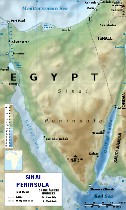
Sinai Peninsula
 | |
| Area | 60,000 km 2(23,000 sq mi) |
|---|---|
| Population | 1,400,000 |
| Countries |
|
The Sinai Peninsula or simply Sinai (now usually /ˈsaɪnaɪ/) is a peninsula in Egypt, and the only part of the country located in Asia. It is situated between the Mediterranean Sea to the north and the Red Sea to the south, and is a land bridge between Asia and Africa. Sinai has a land area of about 60,000 km2 (23,000 sq mi) and a population of approximately 1,400,000 people. Administratively, the Sinai Peninsula is divided into two governorates: the South Sinai Governorate and the North Sinai Governorate. Three other governorates span the Suez Canal, crossing into African Egypt: Suez Governorate on the southern end of the Suez Canal, Ismailia Governorate in the center, and Port Said Governorate in the north.
The Sinai Peninsula has been a part of Egypt from the First Dynasty of ancient Egypt (c. 3100 BC). This comes in stark contrast to the region north of it, the Levant (present-day territories of Syria, Lebanon, Jordan, Israel and Palestine), which, due largely to its strategic geopolitical location and cultural convergences, has historically been the center of conflict between Egypt and various states of Mesopotamia and Asia Minor. In periods of foreign occupation, the Sinai was, like the rest of Egypt, also occupied and controlled by foreign empires, in more recent history the Ottoman Empire (1517–1867) and the United Kingdom (1882–1956). Israel invaded and occupied Sinai during the Suez Crisis (known in Egypt as the Tripartite Aggression due to the simultaneous coordinated attack by the UK, France and Israel) of 1956, and during the Six-Day War of 1967. On 6 October 1973, Egypt launched the Yom Kippur War to retake the peninsula, which was unsuccessful. In 1982, as a result of the Israel–Egypt Peace Treaty of 1979, Israel withdrew from all of the Sinai Peninsula except the contentious territory of Taba, which was returned after a ruling by a commission of arbitration in 1989.
Today, Sinai has become a tourist destination due to its natural setting, rich coral reefs, and biblical history. Mount Sinai is one of the most religiously significant places in the Abrahamic faiths.
Name
The name Sinai (Hebrew: סִינַי, Classical Syriac: ܣܝܢܝ) may have been derived from the ancient moon-god Sin[1] or from the Hebrew word Seneh (Hebrew: סֶ֫נֶּה Senneh)[2] The peninsula acquired the name due to the assumption that a mountain near Saint Catherine's Monastery is the Biblical Mount Sinai. However this assumption is contested.[3]
Its modern Arabic name is سِينَاء Sīnāʼ (Egyptian Arabic سينا Sīna; IPA: [ˈsiːnæ]). The modern Arabic is an adoption of the biblical name, the 19th-century Arabic designation of Sinai was Jebel el-Tûr.[4] In addition to its formal name, Egyptians also refer to it as Arḍ ul-Fairūz (أرض الفيروز 'the land of turquoise'). The ancient Egyptians called it Ta Mefkat, or 'land of turquoise'.[5]
In English, the name is now usually pronounced /ˈsaɪnaɪ/.[6][7] The traditional pronunciation is /ˈsaɪneɪ/ or /ˈsaɪneɪaɪ/.[8][9]
Geography
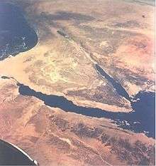
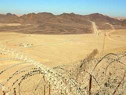
Sinai is triangular in shape, with northern shore lying on the southern Mediterranean Sea, and southwest and southeast shores on Gulf of Suez and Gulf of Aqaba of the Red Sea. It is linked to the African continent by the Isthmus of Suez, 125 kilometres (78 mi) wide strip of land, containing the Suez Canal. The eastern isthmus, linking it to the Asian mainland, is around 200 kilometres (120 mi) wide. The peninsula's eastern shore separates the Arabian plate from the African plate.[10]
The southernmost tip is the Ras Muhammad National Park.
Most of the Sinai Peninsula is divided among the two governorates of Egypt: South Sinai (Ganub Sina) and North Sinai (Shamal Sina).[11] Together, they comprise around 60,000 square kilometres (23,000 sq mi) and have a population (January 2013) of 597,000. Three more governates span the Suez Canal, crossing into African Egypt: Suez (el-Sewais) is on the southern end of the Suez Canal, Ismailia (el-Isma'ileyyah) in the centre, and Port Said in the north.
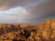
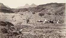
The largest city of Sinai is Arish, capital of the North Sinai, with around 160,000 residents. Other larger settlements include Sharm el-Sheikh and El-Tor, on the southern coast. Inland Sinai is arid (effectively a desert), mountainous and sparsely populated, the largest settlements being Saint Catherine and Nekhel.[11]
Climate
Sinai is one of the coldest provinces in Egypt because of its high altitudes and mountainous topographies. Winter temperatures in some of Sinai's cities and towns reach −16 °C (3 °F).
History
| Sinai Peninsula in hieroglyphs | |||||||
|---|---|---|---|---|---|---|---|
|
| |||||||
|
Biau Bj3w[12] 'Mining country'[12] | |||||||
Ancient Egypt
Sinai was called Mafkat or 'country of turquoise' by the ancient Egyptians[13][14] From the time of the First Dynasty or before, the Egyptians mined turquoise in Sinai at two locations, now called by their Egyptian Arabic names Wadi Magharah and Serabit El Khadim. The mines were worked intermittently and on a seasonal basis for thousands of years. Modern attempts to exploit the deposits have been unprofitable. These may be the first historically attested mines.
Achaemenid Persian Period
At the end of the time of Darius I, the Great (521–486 BCE) Sinai was part of the Persian province of Abar-Nahra, which means 'beyond the river [Euphrates]'.[15]
Cambyses successfully managed the crossing of the hostile Sinai Desert, traditionally Egypt's first and strongest line of defence, and brought the Egyptians under Psamtik III, son and successor of Ahmose, to battle at Pelusium. The Egyptians lost and retired to Memphis; the city fell to the Persian control and the Pharaoh was carried off in captivity to Susa in mainland Persia.
Roman and Byzantine Periods
After the death of the last Nabatean king, Rabbel II Soter, in 106,[16] the Roman emperor Trajan faced practically no resistance and conquered the kingdom on 22 March 106. With this conquest, the Roman Empire went on to control all shores of the Mediterranean Sea. The Sinai Peninsula became part of the Roman province of Arabia Petraea.[17]
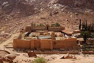
Saint Catherine's Monastery on the foot of Mount Sinai was constructed by order of the Emperor Justinian between 527 and 565. Most of the Sinai Peninsula became part of the province of Palaestina Salutaris in the 6th century.
Ayyubid Period
During the Crusades it was under the control of Fatimid Caliphate. Later, Saladin abolished the Fatimid Caliphate in Egypt and took this region under his control too. It was the military route from Cairo to Damascus during the Crusades. And in order to secure this route, he built a citadel on the island of Pharaoh in Taba known by his name 'Saladin's citadel'.
Mamluk and Ottoman Periods
The peninsula was governed as part of Egypt under the Mamluk Sultanate of Egypt from 1260 until 1517, when the Ottoman Sultan, Selim the Grim, defeated the Egyptians at the Battles of Marj Dabiq and al-Raydaniyya, and incorporated Egypt into the Ottoman Empire. From then until 1906, Sinai was administered by the Ottoman provincial government of the Pashalik of Egypt, even following the establishment of the Muhammad Ali Dynasty's rule over the rest of Egypt in 1805.
British control
In 1906, the Ottoman Porte formally transferred administration of Sinai to the Egyptian government, which essentially meant that it fell under the control of the United Kingdom, who had occupied and largely controlled Egypt since 1882. The border imposed by the British runs in an almost straight line from Rafah on the Mediterranean shore to Taba on the Gulf of Aqaba. This line has served as the eastern border of Egypt ever since.
Wars with Israel (1948, 56, 67, 67–70, 73)
At the beginning of the 1948 Arab–Israeli War, Egyptian forces entered the former British Mandate of Palestine from Sinai to support Palestinian and other Arab forces against the newly declared State of Israel. For a period during the war, Israeli forces entered the north-eastern corner of Sinai.[18] With the exception of Palestine's Gaza Strip, which came under the administration of the All-Palestine Government,[19] the western frontier of the former Mandate of Palestine became the Egyptian–Israeli frontier under the 1949 Armistice Agreement. In 1958, the Gaza Strip came under direct Egyptian military administration, though it was governed separately from Sinai, and was never annexed by Egypt. The Egyptian government maintained that Egyptian administration would be terminated upon the end of the conflict with Israel.
In 1956, Egypt nationalised the Suez Canal,[20] a waterway marking the boundary between Egyptian territory in Africa and the Sinai Peninsula. Thereafter, Israeli ships were prohibited from using the Canal,[21] owing to the state of war between the two states. Egypt also prohibited ships from using Egyptian territorial waters on the eastern side of the peninsula to travel to and from Israel, effectively imposing a blockade on the Israeli port of Eilat. In October 1956, in what is known in Egypt as the Tripartite Aggression, Israeli forces, aided by Britain, and France (which sought to reverse the nationalization and regain control over the Suez Canal), invaded Sinai and occupied much of the peninsula within a few days. In March 1957, Israel withdrew its forces from Sinai, following strong pressure from the United States and the Soviet Union. Thereafter, the United Nations Emergency Force (UNEF) was stationed in Sinai to prevent any further conflict in the Sinai.
On 16 May 1967, Egypt ordered the UNEF out of Sinai[22] and reoccupied it militarily. Secretary-General U Thant eventually complied and ordered the withdrawal without Security Council authorisation. In the course of the Six-Day War that broke out shortly thereafter, Israel occupied the entire Sinai Peninsula, and Gaza Strip from Egypt, the West Bank (including East Jerusalem) from Jordan (which Jordan had controlled since 1949), and the Golan Heights from Syria. The Suez Canal, the east bank of which was now occupied by Israel, was closed. Israel commenced efforts at large scale Israeli settlement in the Sinai Peninsula.
Following the Israeli conquest of Sinai, Egypt launched the War of Attrition (1967–70) aimed at forcing Israel to withdraw from the Sinai. The war saw protracted conflict in the Suez Canal Zone, ranging from limited to large scale combat. Israeli shelling of the cities of Port Said, Ismailia, and Suez on the west bank of the canal, led to high civilian casualties (including the virtual destruction of Suez), and contributed to the flight of 700,000[23] Egyptian internal refugees. Ultimately, the war concluded in 1970 with no change in the front line.[24]
On 6 October 1973, Egypt commenced Operation Badr to retake the Sinai, while Syria launched a simultaneous operation to retake the Golan Heights, thereby beginning the Yom Kippur War (known in Egypt and much of Europe as the October War). Egyptian engineering forces built pontoon bridges to cross the Suez Canal, and stormed the Bar-Lev Line, Israel's defensive line along the Suez Canal's east bank. Though the Egyptians maintained control of most of the east bank of the Suez Canal, in the later stages of the war, the Israeli military crossed the southern section of the Suez Canal, cutting off the Egyptian 3rd Army, and occupied a section of the Suez Canal's west bank. The war ended following a mutually agreed-upon ceasefire. After the war, as part of the subsequent Sinai Disengagement Agreements, Israel withdrew from immediate proximity with the Suez Canal, with Egypt agreeing to permit passage of Israeli ships. The canal was reopened in 1975, with President Sadat leading the first convoy through the canal aboard an Egyptian destroyer.
1979 Peace Treaty with Israel and aftermath
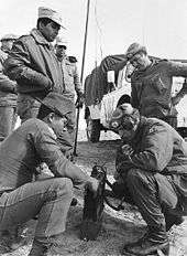
In 1979, Egypt and Israel signed a peace treaty in which Israel agreed to withdraw from the entirety of the Sinai Peninsula. Israel subsequently withdrew in several stages, ending in 1982. The Israeli pull-out involved dismantling almost all Israeli settlements, including the settlement of Yamit in north-eastern Sinai. The exception was that the coastal city of Sharm el-Sheikh (which the Israelis had founded as Ofira during their occupation of the Sinai Peninsula) was not dismantled. The Treaty allows monitoring of Sinai by the Multinational Force and Observers, and limits the number of Egyptian military forces in the peninsula.
Early 21st Century security issues
Since the early 2000s, Sinai has been the site of several terror attacks against tourists, the majority of whom are Egyptian. Investigations have shown that these were mainly motivated by a resentment of the poverty faced by many Bedouin in the area. Attacking the tourist industry was viewed as a method of damaging the industry so that the government would pay more attention to their situation.[25] (See 2004 Sinai bombings, 2005 Sharm El Sheikh bombings and 2006 Dahab bombings). Since the 2011 Egyptian Revolution, unrest has become more prevalent in the area including the 2012 Egyptian-Israeli border attack in which 16 Egyptian soldiers were killed by militants. (See Sinai insurgency).
Also on the rise are kidnappings of refugees. According to Meron Estifanos, Eritrean refugees are often kidnapped by Bedouin in the northern Sinai, tortured, raped, and only released after receiving a large ransom.[26][27]
Under President el-Sisi, Egypt has implemented a rigorous policy of controlling the border to the Gaza Strip, including the dismantling of tunnels between Gaza and Sinai.[28]
Demographics
The two governorates of North and South Sinai have a total population of 597,000 (January 2013). This figure rises to 1,400,000 by including Western Sinai, the parts of the Port Said, Ismailia and Suez Governorates lying east of the Suez Canal. Port Said alone has a population of roughly 500,000 people (January 2013). Portions of the populations of Ismailia and Suez live in west Sinai, while the rest live on the western side of the Suez Canal.
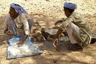
The population of Sinai has largely consisted of desert-dwelling Bedouins with their colourful traditional costumes and significant culture.[29] Large numbers of Egyptians from the Nile Valley and Delta moved to the area to work in tourism, but development adversely affected the native Bedouin population. In order to help alleviate their problems, various NGOs began to operate in the region, including the Makhad Trust, a UK charity that assists the Bedouin in developing a sustainable income while protecting Sinai's natural environment, heritage and culture.
Economy
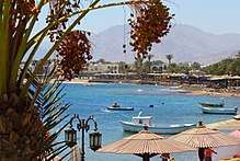
Since the Israeli–Egyptian peace treaty, Sinai's scenic spots (including coral reefs offshore) and religious structures have become important to the tourism industry. The most popular tourist destination in Sinai are Mount Sinai (Jabal Musa) and St Catherine's Monastery, which is considered to be the oldest working Christian monastery in the world, and the beach resorts of Sharm el-Sheikh, Dahab, Nuweiba and Taba. Most tourists arrive at Sharm el-Sheikh International Airport, through Eilat, Israel and the Taba Border Crossing, by road from Cairo or by ferry from Aqaba in Jordan.
See also
|
|
References
- ↑ "Sinai Peninsula (peninsula, Egypt) - Britannica Online Encyclopedia". Britannica.com. Retrieved 14 January 2012.
- ↑ "Sinai, Mount". JewishEncyclopedia.com. Retrieved 14 January 2012.
- ↑ See Biblical Mount Sinai for a fuller discussion.
- ↑ J. W. Parker, The Bible Cyclopaedia vol. 2 (1843), p. 1143. Arthur Penrhyn Stanley, Sinai and Palestine: In Connection with Their History (1877), p. 29.
- ↑ "Étude de la turquoise : de ses traitements et imitations" Archived 15 December 2013 at the Wayback Machine., thesis by Claire Salanne, Université de Nantes, 2009.
- ↑ "Definition of Sinai". The Free Dictionary. Retrieved 3 May 2014.
- ↑ "Sinai". Dictionary.com. Retrieved 3 May 2014.
- ↑ John FARRAR (Classical Tutor at the Wesleyan Theological Institution, Richmond.) (1839). The Proper Names of the Bible; Their Orthography, Pronunciation, and Signification, Etc. p. 227.
- ↑ A Pronouncing Dictionary of the Holy Bible: Being a Concordance of Subjects and Complete Index to the Holy Scriptures. Virtue and Yorston. 1869. p. 215.
- ↑ Homberg, Catherine and Martina Bachmann, Evolution of the Levant Margin and Western Arabia Platform Since the Mesozoic, The Geological Society of London, 2010, p 65 ISBN 978-1862393066
- 1 2 Ned Greenwood (1 January 2010). The Sinai: A Physical Geography. University of Texas Press. pp. 4–. ISBN 978-0-292-77909-9.
- 1 2 The translation 'mining country' is not certain, see also Rainer Hannig: Großes Handwörterbuch Ägyptisch-Deutsch : (2800 - 950 v. Chr.). p. 1135.
- ↑ http://www.egyptsearch.com/forums/ultimatebb.cgi?ubb=print_topic;f=8;t=008397
- ↑ Joseph Davidovits and Ralph Davidovits (2007). "Why Djoser's blue Egyptian faience tiles are not blue? Manufacturing Djoser's faience tiles at temperatures as low as 250 °C?". In Jean Claude Goyon, Christine Cardin. Proceedings of the ninth International Congress of Egyptologists (PDF). 1. Louvain/Paris/Dudley. p. 375.
- ↑ Iranchamber
- ↑ Schürer, Emil; Millar, Fergus; Vermes, Geza (26 March 2015). The History of the Jewish People in the Age of Jesus Christ:. Bloomsbury Academic. p. 583. ISBN 978-0-567-50161-5.
- ↑ Taylor, Jane: Petra And the Lost Kingdom of the Nabataeans. I. B. Tauris 2001, ISBN 1860645089, p. 73-74 (online copy, p. 73, at Google Books)
- ↑ Rogan, Eugene L. and Avi Shlaim, eds. The War for Palestine: Rewriting the History of 1948. 2nd edition. Cambridge: Cambridge UP, p. 99, 2007
- ↑ Shlaim, Avi (2001). Israel and the Arab Coalition. In Eugene Rogan and Avi Shlaim (eds.). The War for Palestine (pp. 97). Cambridge: Cambridge University Press. ISBN 978-0-521-79476-3
- ↑ http://www.history.com/this-day-in-history/egypt-nationalizes-the-suez-canal
- ↑ "1956: Egypt Seizes Suez Canal". BBC. 26 July 1956.
- ↑ Samir A. Mutawi (18 July 2002). Jordan in the 1967 War. Cambridge University Press. p. 93. ISBN 978-0-521-52858-0.
Although Eshkol denounced the Egyptians, his response to this development was a model of moderation. His speech on 21 May demanded that Nasser withdraw his forces from Sinai but made no mention of the removal of UNEF from the Straits nor of what Israel would do if they were closed to Israeli shipping. The next day Nasser announced to an astonished world that henceforth the Straits were, indeed, closed to all Israeli ships
- ↑ Spencer, Tucker. Encyclopedia or the Arab-Israeli Conflict. p. 175.
- ↑ "War of Attrition".
- ↑ Serene Assir (23 July 2005). "Shock in Sharm". Al-Ahram Weekly. Retrieved 29 March 2014.
- ↑ Meron Stefanos on the torture houses in north Sinai
- ↑ Sound of Torture documentary
- ↑ http://www.al-monitor.com/pulse/originals/2015/04/egypt-sinai-gaza-tunnels-sanctions-sisi-terrorist.html#
- ↑ Leonard, William R. and Michael H. Crawford, The Human Biology of Pastoral Populations, Cambridge University Press, 2002, p. 67 ISBN 978-0521780162
Further reading
- Gardner, Ann. "At Home in South Sinai". Nomadic Peoples 2000. Vol. 4, Iss. 2; pp. 48–67. Detailed account of Bedouin women
- H. J. L. Beadnell (May 1926). "Central Sinai". Geographical Journal. 67 (5): 385–398. doi:10.2307/1782203. JSTOR 1782203.
- C. W. Wilson (1873). "Recent Surveys in Sinai and Palestine". Journal of the Royal Geographical Society of London. 43: 206–240. doi:10.2307/1798627. JSTOR 1798627.
- Jacobs, Jessica (2006). "Tourist Places and Negotiating Modernity: European Women and Romance Tourism in the Sinai". In Minca, Claudio; Oakes, Tim. Travels in Paradox: Remapping Tourism. Rowman & Littlefield. ISBN 978-0-7425-2876-5. Retrieved 7 January 2010.
- Teague, Matthew; Moyer, Matt (March 2009). "The Sinai's Separate Peace". National Geographic Magazine. Washington, D.C.: National Geographic Society. 215 (3): 99–121. ISSN 0027-9358. Retrieved 7 January 2010.
- Jarvis, C.S.,Yesterday and To-day in Sinai (Edinburgh/London: W. Blackwood & Sons, 1931).
- New terrorist challenges in the Sinai peninsula, prominent jihadists organisations, Strategic Impact (52), issue: 3 / 2014, pp. 39-47
External links
| Wikimedia Commons has media related to Sinai Peninsula. |
| Wikivoyage has a travel guide for Sinai Peninsula. |
- Guide to Sinai, covering background information on history, flora, fauna, desert, Bedouin, safaris and geology of Sinai
- Sinai Local Magazine
- The Complete Guide To: The Sinai, The Independent, 15 March 2008.
- Sinai in ancient Egypt
- Broadcasting videos from Sinai
- Images of the Sinai Desert
- IRIN humanitarian news: EU grant to tackle rural poverty in South Sinai
- Sinai trekking and safari: route maps and photo archive
| Sovereign states |
|
|---|---|
| States with limited recognition | |
| Dependencies and other territories | |
| |
| Authority control |
|---|