False Bay
| False Bay Valsbaai | |
|---|---|
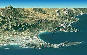
 Eastern False Bay coast aerial view looking somewhat south of east: Gordon's Bay (left) to Cape Hangklip (right) | |
 False Bay Location in South Africa  False Bay False Bay (South Africa) | |
| Coordinates | 34°13.19′S 18°38.4′E / 34.21983°S 18.6400°ECoordinates: 34°13.19′S 18°38.4′E / 34.21983°S 18.6400°E |
| Ocean/sea sources | Southern Atlantic Ocean |
| Basin countries | South Africa |
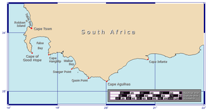
False Bay (Afrikaans Valsbaai) is a body of water defined by Cape Hangklip (Dutch/Afrikaans for "Hang(ing)-rock") and the Cape Peninsula in the extreme south-west of South Africa.
Description and location
The eastern and western shores of the bay are very rocky and even mountainous; in places large cliffs plunge into deep water. Notable peaks associated with the bay include Koeëlberg (1289m / 4229 feet), which rises from the water itself forming the highest point of the Kogelberg, as well as Somerset Sneeukop (1590m / 5217 feet) and Wemmershoek Peak (1788m / 5866 feet) which are clearly visible across the bay. The highest peak visible across False Bay is Du Toits Peak near Paarl (1995m / 6545 feet). The northern shore, however, is defined by a very long, curving, sandy beach. This sandy, northern perimeter of the bay is the southern edge of the area known as the Cape Flats. The bay is 30 kilometres wide at its widest point.[1]
Some 20 kilometres across the Cape Flats, to the north, there is a smaller, C-shaped bay — Table Bay — with Robben Island guarding its entrance. The central districts of Cape Town lie around Table Bay. Devil's Peak, Table Mountain, Lion's Head and Signal Hill form an amphitheatre along the western edge of the Cape Flats. Suburbs of Greater Cape Town now stretch right across the Cape Flats from Table Bay to the shores of False Bay and down the eastern flank of the Cape Peninsula for many kilometres.
History
Bartolomeu Dias in 1488 first referred to the bay as "the gulf between the mountains" (Schirmer, 1980). The name "False Bay" was applied early on (at least three hundred years ago) by sailors who confused the bay with Table Bay to the north. According to Schirmer, the confusion arose because sailors returning from the east (The Dutch East Indies) initially confused Cape Point and Cape Hangklip, which are somewhat similar in form. Hangklip was known to the early Portuguese seafarers as Cabo Falso, or False Cape, and the name of the bay derived from the cape.
Climate
The climate is Mediterranean, with warm, dry summers and cool, damp winters. In winter gales and storms from the northwest are common and can be ferocious. False Bay is exposed to southeasterly winds in summer and its waters are approximately 6 °C warmer than those of Table Bay, owing to the influence of the warm Agulhas Current.
Marine life and recreational pursuits
Fishing is good in False Bay and at times there are large schools of snoek, an oily, barracuda-like fish that is much sought after locally. Angling from the rocky shores to either side of the bay is very popular, but dangerous. The shape of the bay creates interference patterns in the swells that come in from the Southern Ocean and these patterns occasionally combine to cause "killer waves" to rise up without warning and to sweep the sandstone ledges well above the high tide mark. Scores of fishermen have been swept away and drowned over the years, but this seems to have done little to dampen enthusiasm for the sport.
Sailing is also a popular recreational activity in False Bay. The "killer waves" mentioned earlier can wreak havoc with moored sailboats, especially if the moorings are chain based and on the leeward side when the south-easterly winds are howling up the bay. The sailing clubs in False Bay include False Bay Yacht Club in Simon's Town, Fish Hoek Beach Sailing Club at the main beach in Fish Hoek, Gordon's Bay Yacht Club in the Gordon's Bay Harbour, and Hottentots Holland Beach Sailing Club in Strand.
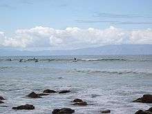
There is a small granite island in the bay (not discernible in the image above) called Seal Island, which is one of the main breeding sites for the Cape fur seal. (Seal Island can be seen in a scan in the article on the Cape Flats). The seals attract many great white sharks and some of the biggest sharks ever seen have been spotted in these waters. These sharks are famous for the manner in which they breach the surface of the water while attacking seals, sometimes jumping entirely out of the ocean. Despite this, swimming, surfing, yachting, scuba diving and so on are popular pastimes around the bay, at centres such as Muizenberg, Kalk Bay, Smitswinkel Bay, Strand and Gordon's Bay. Shark attacks are generally uncommon but by no means unknown, with two deaths since 2010.[2]
Naval base at Simon's Town
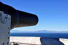
The famous naval base of Simon's Town is situated on the Bay, about halfway down the length of the Cape Peninsula. During the Second World War many heavy guns were dug into concrete bunkers at various points along the mountainous shores of False Bay in order to deter attacks on Simon's Town. The firepower and defensive situation of these weapons were formidable and no attack was ever mounted. Although some of the guns were removed decades ago many large guns are still emplaced on the hillsides near the Redhill road.
Development and human impact
Although urban development of the coast is intense along some parts of False Bay, much of the shoreline remains relatively wild and unspoiled. The bulk of the development is residential; there is little heavy industry. There are a few exceptions, however: one of the largest dynamite factories in the world used to lie near the beach towards the wild and uninhabited eastern end of the bay. The nitroglycerine plant at this installation blew up twice in the second half of the 20th century and sent massive shockwaves across the bay, breaking windows and rattling walls on the distant shores. False Bay is remarkably poor in natural harbours. Almost all protection for shipping and yachts has been created by artificial means (e.g. at Kalkbaai, Simon's Town and Gordon's Bay).
See also
References
- ↑ GoogleEarth
- ↑ "The complete South African Shark Attack Related Incident Record". Retrieved 23 April 2012.
Works cited
- Schirmer, P. 1980. The concise illustrated South African Encyclopaedia. Central News Agency, Johannesburg. First edition, about 211pp.
.svg.png)