Islands Region
| Islands Region | |
|---|---|
| Region | |
 | |
| Coordinates: 4°21′S 152°16′E / 4.350°S 152.267°ECoordinates: 4°21′S 152°16′E / 4.350°S 152.267°E | |
| Country |
|
| Largest city | Arawa |
| Area | |
| • Total | 56,602 km2 (21,854 sq mi) |
| Population (2011)[1] | |
| • Total | 1,096,543 |
| • Density | 19/km2 (50/sq mi) |
| Time zone | UTC+10 (AEST) |
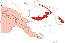
The Islands Region is one of four regions of Papua New Guinea (PNG) comprising the Bismarck Archipelago and north-eastern Solomon Islands Archipelago, located north-east of the mainland on eastern New Guinea island.
This is the least populous inhabited region of the country with an estimated population of 1,096,000 (15% of PNG) in 2011.[2]
It is distinct through its prehistory and history, as shown by the prevalence of Austronesian languages, and archeological findings of Lapita pottery culture.
Subdivision
The Region is administratively divided into five provinces:
References
- ↑ Papua New Guinea National Statistical Office (November 2013). "2011 National Population & Housing Census: Final Figures Booklet". Retrieved 10 June 2018.
- ↑ PNG National Statistical Office
See also
This article is issued from
Wikipedia.
The text is licensed under Creative Commons - Attribution - Sharealike.
Additional terms may apply for the media files.