Bushveld
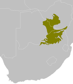
The Bushveld is a sub-tropical woodland ecoregion of Southern Africa named after the term veld. It encompasses most of Limpopo Province and a small part of the North West Province of South Africa, the Central and North-East Districts of Botswana and the Matabeleland South and part of the Matabeleland North provinces of Zimbabwe. Kruger National Park in South Africa has a number of 'Bushveld' camps.[1]
Geography
The elevation of this region varies from 750 to 1,400 m and the annual rainfall from 350 mm in the west to 600 mm in parts of the northeast. There are four significant mountain ranges in this region:the Magaliesberg which runs from Rustenburg in the west to Bronkhorstspruit in the east and forms the southern border of the Bushveld; the Drakensberg escarpment that forms the eastern border of the Bushveld and runs from Tzaneen in the north to Belfast in the south; the Waterberg range that is in the middle of the Bushveld and the Soutpansberg range just north of Louis Trichardt. The latter is the northernmost mountain range in South Africa.
Flora and fauna
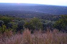
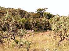
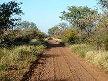
As implied by the region's name, the Bushveld's well-grassed plains are dotted by dense clusters of trees and tall shrubs. The grasses found here are generally tall and turn brown or pale in winter, which is the dry season throughout most of Southern Africa. The undisturbed portions of this habitat, such as much of the Waterberg Biosphere, are home to many large mammal species including white rhino, black rhino, giraffe, blue wildebeest, kudu, impala and a variety of further antelope species and other game.
Geology
The Bushveld is one of the most mineral-rich regions of the world. This is due to the Bushveld igneous complex, an extremely rich saucer-shaped geological formation that stretches over more than 50,000 square kilometers. This formation contains most of the world's reserves of minerals such as andalusite, chromium, fluorspar, platinum and vanadium. The complex includes the Merensky Reef, which is the world's biggest source of platinum as well as platinum-group metals.
Farming
As most of the region tends to be dry, the Bushveld is mostly beef cattle and game farming country, with only a few drought-resistant crops such as sorghum and millet being farmed, usually under irrigation.
Middleveld
The term Middleveld is sometimes used to describe land lying between an altitude of 600m and 1200m[2] and has been synonymous with the term Bushveld.[3]
Towns and cities
Towns and cities in the region include:
- Bela Bela (formerly Warmbaths)
- Brits
- De Wildt
- Haenertsburg
- Hammanskraal
- Lephalale (formerly Ellisras)
- Louis Trichardt
- Mara
- Modimolle (formerly Nylstroom)
- Mokopane (formerly Potgietersrus)
- Mookgophong (formerly Naboomspruit)
- Musina (formerly Messina)
- Northam
- Phalaborwa
- Pienaarsrivier
- Polokwane (formerly Pietersburg)
- Roedtan
- Selebi-Phikwe
- Sun City
- Thabazimbi
- Vaalwater
- Vivo
- Zion City Moria
- Rustenburg
See also
References
- ↑ "Kruger National Park Camping". Kruger National Park Camping. Retrieved 2013-01-09.
- ↑ https://www.britannica.com/science/veld#ref417811
- ↑ South Africa. Department of Agriculture (1955). Bulletin.
External links
- "Southern Africa bushveld". Terrestrial Ecoregions. World Wildlife Fund.