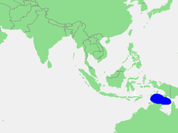
Arafura Sea
| Arafura Sea | |
|---|---|
 Location | |
 Arafura Sea | |
 Map | |
| Location | South Asia |
| Coordinates | 9°00′S 133°0′E / 9.000°S 133.000°ECoordinates: 9°00′S 133°0′E / 9.000°S 133.000°E |
| Type | Sea |
| Basin countries | Australia, Indonesia, Papua New Guinea |
| Max. length | 1,290 km (800 mi) |
| Max. width | 560 km (350 mi) |
| Islands | Aru Islands, Croker Island, Goulburn Islands, Howard Island |
| References | [1] |
The Arafura Sea lies west of the Pacific Ocean, overlying the continental shelf between Australia and Indonesian New Guinea.
Geography
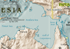
The Arafura Sea is bordered by the Torres Strait and through that the Coral Sea to the east, the Gulf of Carpentaria to the south, the Timor Sea to the west and the Banda and Ceram seas to the northwest. It is 1,290 kilometres (800 mi) long and 560 kilometres (350 mi) wide. The depth of the sea is mainly 50–80 metres (165–260 feet), with the depth increasing to the west.
The sea lies over the Arafura Shelf, part of the Sahul Shelf. When sea levels were low during the last glacial maximum, the Arafura Shelf, the Gulf of Carpentaria and the Torres Strait formed a large flat land bridge connecting Australia and New Guinea and easing migration of humans from Asia into Australia. The combined landmass formed the continent of Sahul.
Extent
The International Hydrographic Organization (IHO) defines the Arafura Sea as being one of the waters of the East Indian Archipelago. The IHO defines its limits as follows:[2]
On the North. The Southeastern limit of the Ceram Sea [A line from Karoefa, New Guinea, to the Southeastern extreme of Adi Island, thence to Tg. Borang, the Northern point of Noehoe Tjoet [Kai Besar] (5°17′S 133°09′E / 5.283°S 133.150°E)] and the Eastern limit of the Banda Sea [From Tg Borang, the Northern point of Noehoe Tjoet, through this island to its Southern point, thence a line to the Northeast point of Fordata, through this island and across to the Northeast point of Larat, Tanimbar Islands (7°06′S 131°55′E / 7.100°S 131.917°E), down the East coast of Jamdena [Yamdena] Island to its Southern point, thence through Anggarmasa to the North point of Selaroe and through this island to Tg Aro Oesoe its Southern point (8°21′S 130°45′E / 8.350°S 130.750°E)].
On the East. The Southwest coast of New Guinea from Karoefa (133°27'E) to the entrance to the Bensbak River (141°01'E), and thence a line to the Northwest extreme of York Peninsula, Australia (11°05′S 142°03′E / 11.083°S 142.050°E).
On the South. By the North coast of Australia from the Northwest extreme of York Peninsula to Cape Don (11°19′S 131°46′E / 11.317°S 131.767°E).
On the West. A line from Cape Don to Tanjong Aro Oesoe, the Southern point of Selaroe (Tanimbar Islands).
Name
The sea's name appeared in George Windsor Earl's 1837 Sailing Directions for the Arafura Sea which he compiled from the narratives of Lieuts. Kolff and Modera of the Royal Netherlands Navy.[3]
It has been suggested that the name Arafura is of Portuguese origin, a corruption of the word "Alfours", meaning "free men", but recent research at the Dutch National Archives has revealed that AJ van der Aa's 1939 Toponymic Dictionary records "the inhabitants of the Moluccas called themselves 'haraforas', translating 'Anak anak gunung' as 'children of the mountains'."
European recording of his name dates back to at least 1663 when Blaeu records in the texts on his wall map of the East Indies "Archipelagus Orientalis, sive Asiaticus", that the inland inhabitants of the Moluccas call themselves "Alfores".[4]
The Arafura Sea name is from the indigenous name for "the people of mountains" in the Moluccas (part of Indonesia) as identified by Dutch Lieutenants Kolff and Modera in the 1830s.[3]
Thomas Forrest sailed through the Moluccas (Maluku Islands) in 1775 and retailed reports of "Harafora" people living in the western end of New Guinea in subordination to the "Papuas", and mentioned them also in Magindano (Mindanao).[5] The geographer Conrad Malte-Brun repeated Forrest's reports of a race of "Haraforas", in 1804,[6] and added Borneo to the distribution.[7] The ethnologist James C. Prichard described them as head-hunters.[8] The form "Horrafora" was recorded by John Coulter, in his account[9] of a sojourn in the interior of south-west New Guinea in 1835, and applied to the tribespeople there. Coulter concluded that Papuans and Horraforas were two distinct races in New Guinea.
Fisheries
The Arafura Sea is a rich fishery resource, particularly for shrimp and demersal fishing. Economically important species include Barramundi, grouper, Penaeid shrimp, Nemipteridae fishes, among other kinds of fish.
In a world where marine ecosystems and fish stocks are generally collapsing, the Arafura Sea stands out as among the richest marine fisheries in the world.[10] However, the Arafura is coming under ever more intense pressure from illegal, unreported and unregulated fishing activities.
Established in 2002, the Arafura and Timor Seas Expert Forum (ATSEF) seeks to promote economically and environmentally sustainable management of the seas.[11][12]
See also
| Wikimedia Commons has media related to Arafura Sea. |
References
- ↑ Arafura Sea: OS (Oceans) National Geospatial-Intelligence Agency, Bethesda, MD, USA
- ↑ "Limits of Oceans and Seas, 3rd edition" (PDF). International Hydrographic Organization. 1953. Retrieved 7 February 2010.
- 1 2 Earl, George Windsor; Kolff, D. H.; Modera, Justin (1837). "Sailing directions for the Arafura Sea". Hydrographic Office, London.
- ↑ Joan Blaeu Archipelagus Orientalis, sive Asiaticus Apud Ioannem Blaeu Published: Amsterdam Apud Joannem Blaeu, 1663
- ↑ Captain Thomas Forrest, A Voyage to New Guinea, and the Moluccas, from Balambangan: &c. (Dublin, 1779).
- ↑ Edme Mentelle & Malte Brun, Géographie mathématique, physique et politique de toutes les parties du monde, &c., vol. XII (Paris, Henry Tardieu & Laporte, 1804), pages 400, 597.
- ↑ M. Malte-Brun, Universal Geography, or a Description of All the Parts of the World on a New Plan, &c., vol. III (Edinburgh, Adam Black, 1822).
- ↑ James Clowes Prichard, Researches into the Physical History of Man (London, J. & A. Arch, 1813), page 307.
- ↑ John Coulter, M.D., Adventures on the Western Coast of South America and the Interior of California: including a narrative of incidents at the Kingsmill Islands, New Ireland, New Britain, New Guinea, and other islands in the Pacific Ocean; &c., vol. II (London, Longmans, 1847), chapters 11—16.
- ↑ Biophysical Profile of the Arafura and Timor Seas.
- ↑ Arafura and Timor Seas Expert Forum (ATSEF)
- ↑ The Arafura and Timor Seas Ecosystem Action Program (ATSEA)
| Authority control |
|---|