Republic of West Papua
| Republic of West Papua Republik Papua Barat | |||||||||||||
|---|---|---|---|---|---|---|---|---|---|---|---|---|---|
| 1961–1969 | |||||||||||||
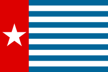 Flag
| |||||||||||||
|
Motto: Setia, Jujur, Mesra (Indonesian) (English: "Loyal, Honest, Affectionate") | |||||||||||||
 | |||||||||||||
| Status | Unrecognized state | ||||||||||||
| Capital | Jayapura | ||||||||||||
| Common languages | Indonesian, English, and Papuan languages | ||||||||||||
| Demonym | Papuan | ||||||||||||
| Government | Republic | ||||||||||||
| History | |||||||||||||
• Established | 1961 | ||||||||||||
| 1 October 1962 | |||||||||||||
| 1 May 1963 | |||||||||||||
| 19 November 1969 | |||||||||||||
• Free Papua Movement proclaimed republic | 1 July 1971 | ||||||||||||
• Dr. Thomas Wainggai proclaimed republic | 14 December 1988 | ||||||||||||
• West Papua National Authority proclaimed federal republic | 19 October 2011 | ||||||||||||
• Disestablished | 1969 | ||||||||||||
| |||||||||||||
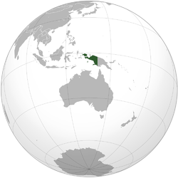
The Republic of West Papua is a proposed, former, and unrecognized state consisting of the Western New Guinea region. The region is claimed by Indonesia and has been occupied by Indonesia since 1 May 1963 under several names in the following order West Irian, Irian Jaya and Papua. Today the region comprises two Indonesian provinces Papua and West Papua.
The proposal is supported by Vanuatu and the Solomon Islands with the Parliament of Vanuatu passing the Wantok Blong Yumi Bill (Our Close Friends) in 2010 officially declaring that Vanuatu's foreign policy is to support the achievement of the independence of West Papua.[1][2][3] Vanuatu's Parliament has proposed requesting that West Papua be granted observer status at the Melanesian Spearhead Group and Pacific Island Forum.[4][5][6]
History
The region was formerly a Kingdom of the Netherlands colony part of the Dutch East Indies and in 1949 was known as Dutch New Guinea. The Dutch had planned to withdraw by 1970 and began "Papuanization" to prepare for independence.[7] In February 1961, the Dutch organised elections for the New Guinea Council a Papuan representative body to advise the Governor.[7][8] The Council appointed a National Committee to prepare a political manifesto for the future state.[7][8] On 1 December 1961, an inauguration ceremony was held for the Morning Star flag raised outside the Council building in the presence of the Governor, also the national anthem "Hai Tanahku Papua", the birds of paradise coat of arms, motto and the name of Papua Barat (West Papua) for the proposed new state.[7][8] The Dutch had accepted the Manifesto except the denomination of the flag recognising it as a territorial flag not a national flag.[8]
On 1 July 1971, Brigadier General Seth Jafeth Rumkorem, leader of the militant independence movement Free Papua Movement (Indonesian: Organisasi Papua Merdeka, (OPM)), proclaimed unilaterally Papua Barat or West Papua as an independent democratic republic.[9] The Morning Star flag was declared as a national flag.[8]
On 14 December 1988, Dr. Thomas Wainggai proclaimed the Republic of West Melanesia using the Melanesian identity of the West Papuan people as the name.[10][11] The West Melanesia flag featured 14 stars with three coloured bars of black, red and white.[10]
On 19 October 2011, Forkorus Yaboisembut, the head of the West Papua National Authority (WPNA), proclaimed the Federal Republic of West Papua (Indonesian: Negara Republik Federal Papua Barat, (NRFPB)) with the Mambruk pigeon as the symbol of state.[12]
In December 2014, all West Papuan independence movement groups united under a single umbrella organisation the United Liberation Movement for West Papua (ULMWP).[13][14]
On 9 November 2017, the OPM's armed wing, the West Papua National Liberation Army (TPN-OPM), seized control of the villages of Kimberly and Banti near the Grasberg mine, holding these villages until retaken by Indonesian forces 8 days later.[15][16][17]
See also
References
- ↑ "Fiery debate over West Papua at UN General Assembly". Radio New Zealand 2017. 27 September 2017. Retrieved 7 October 2017.
- ↑ "Indonesia hits back at Melanesian leaders on West Papua". Radio New Zealand. 27 September 2017. Retrieved 7 October 2017.
- ↑ Manning, Selwyn (22 June 2010). "Vanuatu to seek observer status for West Papua at MSG and PIF leaders summits". Pacific Scoop. Retrieved 20 October 2017.
- ↑ "Indonesia; Vanuatu: Vanuatu Parliament Passes Resolution on West Papua Independence | Global Legal Monitor". www.loc.gov. Buchanan, Kelly. 2010-07-21. Retrieved 2018-05-02.
- ↑ "Vanuatu to seek UN General Assembly support for ICJ opinion on Indonesia's Papua". Radio New Zealand. 2010-06-21. Retrieved 2018-05-02.
- ↑ "Pacific.scoop.co.nz » Vanuatu to seek observer status for West Papua at MSG and PIF leaders summits". pacific.scoop.co.nz. Retrieved 2018-05-02.
- 1 2 3 4 Saltford, John (2003). The United Nations and the Indonesian takeover of West Papua, 1962-1969 : the anatomy of betrayal (PDF). London ; New York: Routledge Curzon. ISBN 0203221877. Retrieved 21 October 2017.
- 1 2 3 4 5 Tanggahma, Leonie (1 December 2012). "A History of the Morning Star Flag of West Papua". West Papua Media. Retrieved 21 October 2017.
- ↑ "West Papua". Unrepresented Nations and People Organization (UNPO). 15 October 2014. Retrieved 20 October 2017.
- 1 2 King, Peter (2004). West Papua & Indonesia since Suharto: independence, autonomy or chaos?. Sydney: University of New South Wales Press. ISBN 9780868406763.
- ↑ "Human Rights in Papua 2010/2011" (PDF). Papua land of peace - faith based network on West Papua. Retrieved 19 October 2017.
- ↑ "Government". Federal State Republic of West Papua. Retrieved 21 October 2017.
- ↑ Ligo, Godwin (10 December 2014). "West Papuans unite under new umbrella group". Vanuatu Daily Post. Retrieved 2 October 2017.
- ↑ Chivers, Danny (10 May 2017). "Morning Star Rising". New Internationalist. Archived from the original on 10 May 2017.
- ↑ "Armed separatists occupy villages near Freeport's Papua mine". abc.net.au. 10 November 2017.
- ↑ "Papua separatists dispute Indonesia's claim of taking hostages". abc.net.au. 10 November 2017.
- ↑ Media, Kompas Cyber. "Detik-detik Menegangkan Operasi Senyap Kopassus dan Kostrad Bebaskan Sandera di Papua - Kompas.com". kompas.com.
External links and further reading
| Wikimedia Commons has media related to West Papua. |
- Free West Papua Campaign
- West Papua Media Alerts site
- United Nations - West New Guinea UNSF
- An article about the history of West Papuan separatism by John Anari (United Nations website)
- Bertrand, Jaques (1997). "Business as Usual" in Suharto's Indonesia. Asian Survey 37(6):441-452.
- Brad Simpson. Indonesia's 1969 Takeover of West Papua Not by "Free Choice". The National Security Archive, George Washington University.