List of 21st-century earthquakes
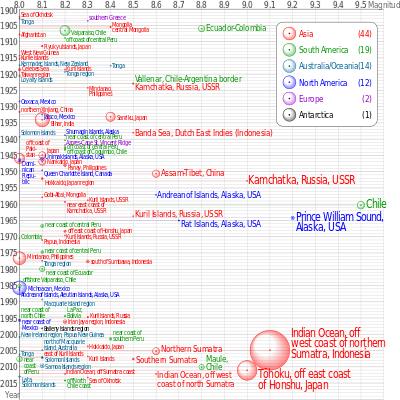
Earthquakes of magnitude 8.0 and greater since 1900. The apparent 3D volumes of the bubbles are linearly proportional to their respective fatalities.[1]
The following is a list of significant earthquakes during the 21st century, listing earthquakes of magnitude 7 and above, or which caused fatalities. Deaths due to earthquake-caused tsunamis are included. In terms of fatalities, the 2010 Haiti earthquake was the most destructive event, followed by the 2004 Indian Ocean earthquake, 2005 Pakistan earthquake and 2008 Sichuan earthquake.
For lists of earthquakes by country, which may include smaller and less destructive events than those listed here, see Lists of earthquakes by country.
2001
| Date | Time (UTC) | Place | Lat. | Long. | Fatalities | Magnitude | Comments | Sources |
|---|---|---|---|---|---|---|---|---|
| January 1, 2001 | 06:57 | Mindanao, Philippines | 6.898 | 126.579 | 0 | 7.5 | Mw (HRV). | |
| January 9, 2001 | 16:49 | Vanuatu | -14.928 | 167.170 | 0 | 7.1 | Mw (USGS). | |
| January 10, 2001 | 16:02 | Kodiak Island region, Alaska, United States | 57.078 | -153.211 | 0 | 7.0 | Mw (HRV). | |
| January 13, 2001 | 17:33 | Offshore El Salvador see January 2001 El Salvador earthquake |
13.049 | -88.660 | 944 | 7.7 | Mw (HRV). | |
| January 26, 2001 | 03:16 | Gujarat, India see 2001 Gujarat earthquake |
23.419 | 70.232 | 20,085 | 7.7 | Mw (HRV). | |
| February 13, 2001 | 14:22 | El Salvador see February 2001 El Salvador earthquake |
13.671 | -88.938 | 315 | 6.6 | Mw (HRV). | |
| February 13, 2001 | 19:28 | Southern Sumatra, Indonesia | -4.680 | 102.562 | 0 | 7.4 | Mw (HRV). | |
| February 17, 2001 | 20:25 | El Salvador see February 2001 El Salvador earthquake |
13.79 | -89.11 | 1 | 4.1 | Mb (USGS). | |
| February 23, 2001 | 00:09 | Western Sichuan, China | 29.513 | 101.129 | 3 | 5.6 | Mw (HRV, USGS). | |
| February 24, 2001 | 07:23 | Molucca Sea | 1.271 | 126.249 | 0 | 7.1 | Mw (HRV, USGS). | |
| February 28, 2001 | 18:54 | Puget Sound region, Washington, United States see 2001 Nisqually earthquake |
47.149 | -122.727 | 1 | 6.8 | Mw (HRV). | |
| March 24, 2001 | 06:27 | Western Honshu, Japan see 2001 Geiyo earthquake |
34.083 | 132.526 | 2 | 6.8 | Mw (HRV). | |
| April 12, 2001 | 10:47 | Yunnan, China | 24.768 | 99.061 | 2 | 5.6 | Mw (HRV, USGS). | |
| May 8, 2001 | 18:02 | El Salvador | 13.605 | -88.795 | 1 | 5.7 | Mw (HRV). | |
| May 23, 2001 | 21:10 | Western Sichuan, China | 27.689 | 101.003 | 2 | 5.5 | Mw (HRV). | |
| June 1, 2001 | 14:00 | Hindu Kush region, Afghanistan | 35.169 | 69.389 | 4 | 5.0 | Mw (HRV). | |
| June 3, 2001 | 02:41 | Kermadec Islands, New Zealand | -29.666 | -178.633 | 0 | 7.2 | Mw (HRV). | |
| June 21, 2001 | 19:55 | Germany | 49.147 | 6.870 | 1 | 4.2 | ML (LDG). | |
| June 23, 2001 | 20:33 | Near the coast of southern Peru see 2001 southern Peru earthquake |
-16.265 | -73.641 | 74 dead 64 missing |
8.4 | Mw (HRV). | |
| July 7, 2001 | 09:38 | -17.543 | -72.077 | 1 | 7.6 | Mw (HRV). | ||
| July 17, 2001 | 15:06 | Northern Italy | 46.735 | 11.201 | 3 dead 1 missing |
4.7 | Mw (CSEM). | |
| July 24, 2001 | 05:00 | Tarapaca, Chile | -19.448 | -69.255 | 1 | 6.4 | Mw (USGS). | |
| August 9, 2001 | 02:06 | Central Peru | -14.258 | -72.683 | 4 | 5.8 | Mw (HRV, USGS). | |
| August 21, 2001 | 06:52 | East of the North Island of New Zealand | -36.813 | -179.575 | 0 | 7.1 | Mw (HRV, USGS). | |
| October 12, 2001 | 15:02 | Guam region | 12.686 | 144.980 | 0 | 7.0 | Mw (HRV). | |
| October 19, 2001 | 03:28 | Banda Sea | -4.102 | 123.907 | 0 | 7.5 | Mw (HRV). | |
| October 27, 2001 | 05:35 | Yunnan, China | 26.316 | 100.648 | 1 | 5.6 | Mw (HRV, USGS). | |
| October 31, 2001 | 09:10 | New Britain region, Papua New Guinea | -5.912 | 150.196 | 0 | 7.0 | Mw (HRV). | |
| November 14, 2001 | 09:26 | Southern Qinghai, China see 2001 Kunlun earthquake |
35.946 | 90.541 | 0 | 7.8 | Mw (HRV). | |
| December 4, 2001 | 05:57 | Southern Peru | -15.350 | -72.516 | 2 | 5.8 | Mw (HRV, USGS). | |
| December 12, 2001 | 14:02 | South of Australia | -42.813 | 124.688 | 0 | 7.1 | Mw (HRV, USGS). |
2002
| Date | Time (UTC) | Place | Lat. | Long. | Fatalities | Magnitude | Comments | Sources |
|---|---|---|---|---|---|---|---|---|
| January 2, 2002 | 17:22 | Vanuatu | -17.600 | 167.856 | 0 | 7.2 | Mw (HRV). | |
| January 9, 2002 | 06:45 | Tajikistan | 38.673 | 69.902 | 3 | 5.3 | Mw (HRV). | |
| January 10, 2002 | 11:14 | Near the north coast of New Guinea, Papua New Guinea | -3.212 | 142.427 | 1 | 6.7 | Mw (HRV). | |
| January 17, 2002 | 20:01 | Lac Kivu region, Democratic Republic of the Congo | -1.684 | 29.077 | 7 | 4.7 | Mb (USGS). | |
| January 21, 2002 | 14:34 | Turkey | 38.664 | 27.881 | 1 | 4.6 | Mb (USGS). | |
| January 22, 2002 | 04:53 | Crete, Greece | 35.790 | 26.617 | 1 | 6.2 | Mw (HRV, USGS). | |
| February 3, 2002 | 07:11 | Western Turkey | 38.573 | 31.271 | 44 | 6.5 | Mw (HRV). | |
| February 17, 2002 | 13:03 | Southern Iran | 28.093 | 51.755 | 1 | 5.4 | Mw (HRV, USGS). | |
| March 3, 2002 | 12:08 | Hindu Kush region, Afghanistan see 2002 Hindu Kush earthquakes |
36.502 | 70.482 | 166 | 7.4 | Mw (HRV). | |
| March 5, 2002 | 21:16 | Mindanao, Philippines see 2002 Mindanao earthquake |
6.033 | 124.249 | 15 | 7.5 | Mw (HRV). | |
| March 25, 2002 | 14:56 | Hindu Kush region, Afghanistan see 2002 Hindu Kush earthquakes |
36.062 | 69.315 | 1,000 | 6.1 | Mw (HRV). | |
| March 31, 2002 | 06:52 | Taiwan region | 24.279 | 122.179 | 5 | 7.1 | Mw (HRV, USGS). | |
| April 1, 2002 | 06:14 | Eastern New Guinea region, Papua New Guinea | -6.191 | 147.421 | 36 | 5.3 | Mw (HRV). | |
| April 12, 2002 | 04:00 | Hindu Kush region, Afghanistan | 35.959 | 69.417 | 50 | 5.9 | Mw (HRV). | |
| April 22, 2002 | 04:57 | Near the coast of Peru | -12.386 | -76.518 | 1 | 4.4 | Mb (USGS). | |
| April 24, 2002 | 10:51 | Serbia, Yugoslavia | 42.436 | 21.466 | 1 | 5.7 | Mw (HRV). | |
| April 24, 2002 | 19:48 | Western Iran | 34.642 | 47.400 | 2 | 5.4 | Mw (HRV). | |
| April 25, 2002 | 17:41 | Georgia | 41.765 | 44.960 | 5 | 4.8 | Mb (USGS). | |
| April 26, 2002 | 16:06 | Guam region | 13.088 | 144.619 | 0 | 7.1 | Mw (HRV, USGS). | |
| May 15, 2002 | 03:46 | Taiwan | 24.636 | 121.922 | 1 | 6.2 | Mw (HRV, USGS). | |
| May 18, 2002 | 15:15 | Lake Victoria region, Tanzania | -2.907 | 33.733 | 2 | 5.5 | Mw (HRV). | |
| June 22, 2002 | 02:58 | Western Iran see 2002 Bou'in–Zahra earthquake |
35.626 | 49.047 | 261 | 6.5 | Mw (HRV, USGS). | |
| June 28, 2002 | 17:19 | Jilin–Heilongjiang border region, China | 43.752 | 130.666 | 0 | 7.3 | Mw (HRV, USGS). | |
| August 19, 2002 | 11:01 | Fiji region | -21.696 | -179.513 | 0 | 7.7 | Mw (HRV). | |
| August 19, 2002 | 11:08 | South of the Fiji Islands | -23.884 | 178.495 | 0 | 7.7 | Mw (HRV, USGS). | |
| September 6, 2002 | 01:21 | Sicily, Italy | 38.381 | 13.701 | 2 | 6.0 | Mw (HRV). | |
| September 8, 2002 | 18:44 | Near the north coast of New Guinea, Papua New Guinea | -3.302 | 142.945 | 4 | 7.6 | Mw (HRV). | |
| September 13, 2002 | 22:28 | Andaman Islands, India region | 13.036 | 93.068 | 2 | 6.5 | Mw (HRV, USGS). | |
| October 10, 2002 | 10:50 | Near the north coast of Papua, Indonesia | -1.757 | 134.297 | 8 | 7.6 | Mw (HRV). | |
| October 24, 2002 | 06:08 | Lac Kivu region, Democratic Republic of the Congo see 2002 Kalehe earthquake |
-1.884 | 29.004 | 2 | 6.2 | Mw (HRV). | |
| October 31, 2002 | 10:32 | Southern Italy see 2002 Molise earthquake |
41.789 | 14.872 | 29 | 5.9 | Mw (USGS). | |
| November 1, 2002 | 22:09 | Northwestern Kashmir | 35.517 | 74.654 | 11 | 5.4 | Mw (HRV). | |
| November 2, 2002 | 01:26 | Simeulue, Indonesia see 2002 Sumatra earthquake |
2.824 | 96.085 | 3 | 7.4 | Mw (USGS). | |
| November 3, 2002 | 22:12 | Central Alaska, United States see 2002 Denali earthquake |
63.517 | -147.444 | 0 | 7.9 | Mw (HRV). | |
| November 17, 2002 | 04:53 | Northwest of the Kuril Islands, Russia | 47.824 | 146.209 | 0 | 7.3 | Mw (HRV, USGS). | |
| November 20, 2002 | 21:32 | Northwestern Kashmir | 35.414 | 74.515 | 19 | 6.3 | Mw (HRV). | |
| December 14, 2002 | 13:27 | Gansu, China | 39.736 | 97.443 | 2 | 5.6 | Mw (USGS). |
2003
| Date | Time (UTC) | Place | Lat. | Long. | Fatalities | Magnitude | Comments | Sources |
|---|---|---|---|---|---|---|---|---|
| January 20, 2003 | 08:43 | Solomon Islands | -10.491 | 160.770 | 0 | 7.3 | Mw (HRV). | |
| January 21, 2003 | 02:46 | Near the coast of Guatemala | 13.626 | -90.774 | 1 | 6.5 | Mw (HRV). | |
| January 22, 2003 | 02:06 | Offshore Colima, Mexico see 2003 Colima earthquake |
18.770 | -104.104 | 29 | 7.6 | Mw (USGS). | |
| January 27, 2003 | 05:26 | Eastern Turkey | 39.500 | 39.878 | 1 | 6.1 | Mw (HRV). | |
| February 24, 2003 | 02:03 | Southern Xinjiang, China see 2003 Bachu earthquake |
39.610 | 77.230 | 261 | 6.3 | Mw (HRV, USGS). | |
| February 25, 2003 | 03:52 | 39.483 | 77.393 | 5 | 5.4 | Mw (HRV). | ||
| March 17, 2003 | 16:36 | Rat Islands, Aleutian Islands, Alaska, United States | 51.272 | 177.978 | 0 | 7.1 | Mw (USGS). | |
| March 25, 2003 | 02:53 | Flores region, Indonesia | -8.294 | 120.743 | 4 | 6.5 | Mw (HRV). | |
| March 29, 2003 | 11:46 | Hindu Kush region, Afghanistan | 35.976 | 70.585 | 1 | 5.9 | Mw (USGS). | |
| May 1, 2003 | 00:27 | Eastern Turkey see 2003 Bingöl earthquake |
39.007 | 40.464 | 177 | 6.4 | Mw (HRV, USGS). | |
| May 1, 2003 | 15:44 | Southern Xinjiang, China | 39.430 | 77.219 | 1 | 5.8 | Mw (HRV). | |
| May 21, 2003 | 18:44 | Northern Algeria see 2003 Boumerdès earthquake |
36.964 | 3.634 | 2,266 | 6.8 | Mw (HRV). | |
| May 26, 2003 | 09:24 | Near the east coast of Honshu, Japan | 38.849 | 141.568 | 0 | 7.0 | Mw (HRV, USGS). | |
| May 26, 2003 | 19:23 | Halmahera, Indonesia | 2.354 | 128.855 | 1 | 7.0 | Mw (HRV). | |
| May 27, 2003 | 17:11 | Northern Algeria see 2003 Boumerdès earthquake |
36.939 | 3.578 | 9 | 5.8 | Mw (USGS). | |
| June 20, 2003 | 06:19 | Amazonas, Brazil | -7.606 | -71.722 | 0 | 7.1 | Mw (HRV). | |
| June 24, 2003 | 13:01 | Western Iran | 32.927 | 49.475 | 1 | 4.6 | Mb (USGS). | |
| July 10, 2003 | 17:06 | Southern Iran | 28.355 | 54.169 | 1 | 5.8 | Mw (HRV). | |
| July 15, 2003 | 20:27 | Carlsberg Ridge | -2.598 | 68.382 | 0 | 7.6 | Mw (HRV). | |
| July 21, 2003 | 15:16 | Yunnan, China | 25.975 | 101.290 | 16 | 6.0 | Mw (USGS). | |
| July 26, 2003 | 23:18 | India–Bangladesh border region | 22.854 | 92.306 | 2 | 5.7 | Mw (HRV). Most damage took place in Bangladesh. | |
| August 4, 2003 | 04:37 | Scotia Sea | -60.532 | -43.411 | 0 | 7.6 | Mw (HRV). | |
| August 16, 2003 | 10:58 | Eastern Nei Mongol, China | 43.770 | 119.643 | 4 | 5.4 | Mw (HRV, USGS). | |
| August 21, 2003 | 12:12 | South Island of New Zealand | -45.104 | 167.144 | 0 | 7.2 | Mw (HRV). | |
| September 22, 2003 | 04:45 | Dominican Republic region see 2003 Dominican Republic earthquake |
19.777 | -70.673 | 3 | 6.4 | Mw (HRV, USGS). | |
| September 25, 2003 | 19:50 | Hokkaido, Japan region see 2003 Hokkaido earthquake |
41.815 | 143.910 | 0 | 8.3 | Mw (HRV). | |
| September 25, 2003 | 21:08 | 41.774 | 143.593 | 7.4 | Mw (HRV). | |||
| September 27, 2003 | 11:33 | Southwestern Siberia, Russia see 2003 Altai earthquake |
50.038 | 87.813 | 3 | 7.3 | Mw (HRV, USGS). | |
| October 16, 2003 | 12:28 | Yunnan, China | 25.954 | 101.254 | 3 | 5.6 | Mw (HRV). | |
| October 25, 2003 | 12:41 | Gansu–Qinghai border region, China | 38.400 | 100.951 | 9 | 5.8 | Mw (HRV, USGS). | |
| October 31, 2003 | 01:06 | Off the east coast of Honshu, Japan | 37.812 | 142.619 | 0 | 7.0 | Mw (HRV, USGS). | |
| November 13, 2003 | 02:35 | Gansu, China | 34.712 | 103.834 | 1 | 5.1 | Mw (HRV). | |
| November 14, 2003 | 18:49 | Sichuan–Yunnan–Guizhou region, China | 27.372 | 103.971 | 4 | 5.6 | Mw (HRV). | |
| November 17, 2003 | 06:43 | Rat Islands, Aleutian Islands, Alaska, United States | 51.146 | 178.650 | 0 | 7.8 | Mw (HRV). | |
| November 18, 2003 | 17:14 | Samar, Philippines | 12.025 | 125.416 | 1 | 6.5 | Mw (HRV, USGS). | |
| December 1, 2003 | 01:38 | Kazakhstan–Xinjiang border region see 2003 Zhaosu earthquake |
42.905 | 80.515 | 11 | 6.0 | Mw (HRV). Most damage took place in Xinjiang, China. | |
| December 22, 2003 | 19:15 | Central California, United States see 2003 San Simeon earthquake |
35.706 | -121.102 | 2 | 6.6 | Mw (HRV). | |
| December 25, 2003 | 07:11 | Panama–Costa Rica border region see 2003 Puerto Armuelles earthquake |
8.416 | -82.824 | 2 | 6.5 | Mw (HRV, USGS). Most damage took place in Panama. | |
| December 26, 2003 | 01:56 | Southeastern Iran see 2003 Bam earthquake |
29.004 | 58.337 | 27,000~31,000 | 6.6 | Mw (USGS) Centred 185 km SE of Kerman, Iran, at a depth of 10 km. | [2] |
| December 27, 2003 | 16:00 | Southeast of the Loyalty Islands, New Caledonia | -22.033 | 169.650 | 0 | 7.3 | Mw (USGS) Centred 185 km ESE of Tadine, Loyalty Islands, New Caledonia, at a depth of 10 km. | [3] |
2004
| Date | Time (UTC) | Place | Lat. | Long. | Fatalities | Magnitude | Comments | Source |
|---|---|---|---|---|---|---|---|---|
| January 1, 2004 | 20:59 | Bali region, Indonesia | -8.310 | 115.788 | 1 | 5.8 | Mw (HRV, USGS). | |
| January 3, 2004 | 16:23 | Southeast of the Loyalty Islands, New Caledonia | -22.253 | 169.683 | 0 | 7.1 | Mw (HRV). | |
| February 5, 2004 | 21:05 | Papua, Indonesia | -3.615 | 135.538 | 37 | 7.0 | Mw (USGS) Centred 95 km WNW of Enarotali, Irian Jaya, Indonesia, at a depth of 16 km. | [4] |
| February 7, 2004 | 02:42 | -4.003 | 135.023 | 7.3 | Mw (USGS) Centred 150 km west of Enarotali, Irian Jaya, Indonesia, at a depth of 10 km. | [5] | ||
| February 14, 2004 | 10:30 | Pakistan | 34.774 | 73.216 | 24 | 5.5 | Mw (USGS). | |
| February 16, 2004 | 14:44 | Southern Sumatra, Indonesia | -0.466 | 100.655 | 5 | 5.1 | Mw (HRV). | |
| February 24, 2004 | 02:14 | Burundi | -3.393 | 29.558 | 3 | 4.7 | Mb (USGS). | |
| February 24, 2004 | 02:27 | Near north coast of Morocco see 2004 Al Hoceima earthquake |
35.142 | -3.997 | 631 | 6.4 | Mw (USGS) Centred 160 km NE of Fes, Morocco, at a depth of 69.2 km. | [6] |
| March 1, 2004 | 23:55 | Eastern Turkey | 38.058 | 38.277 | 6 | 3.8 | MD (ISK). | |
| March 25, 2004 | 19:30 | 39.930 | 40.812 | 10 | 5.6 | Mw (HRV, USGS). | ||
| April 5, 2004 | 21:24 | Hindu Kush region, Afghanistan | 36.527 | 71.028 | 3 | 6.6 | Mw (USGS) Centred 75 km SSE of Feyzabad, Afghanistan, at a depth of 191.4 km. | [7] |
| May 1, 2004 | 07:56 | Taiwan | 24.081 | 121.611 | 2 | 5.2 | Mw (HRV). | |
| May 8, 2004 | 20:11 | Pakistan | 30.126 | 67.121 | 1 | 4.4 | Mb (USGS). | |
| May 28, 2004 | 12:38 | Northern Iran see 2004 Baladeh earthquake |
36.270 | 51.575 | 35 | 6.3 | Mw (USGS) Centred 70 km NNE of TEHRAN, Iran, at a depth of 29 km. | [8] |
| July 1, 2004 | 22:30 | Eastern Turkey | 39.799 | 43.778 | 18 | 5.2 | Mw (USGS) Centred 65 km east of Karakose (Ağrı), Turkey, at a depth of 41.7 km. | [9] |
| July 12, 2004 | 13:04 | Slovenia | 46.296 | 13.641 | 1 | 5.2 | Mw (HRV). | |
| July 15, 2004 | 04:27 | Fiji region | -17.656 | -178.760 | 0 | 7.1 | Mw (HRV). | |
| July 18, 2004 | 04:22 | North Island of New Zealand | -38.000 | 176.510 | 1 | 5.6 | Mw (USGS). | |
| July 18, 2004 | 08:31 | Central Afghanistan | 33.426 | 69.524 | 2 | 5.2 | Mw (HRV). | |
| July 25, 2004 | 14:35 | Southern Sumatra, Indonesia | -2.455 | 103.977 | 0 | 7.3 | Mw (USGS) Centred 105 km NW of Palembang, Sumatra, Indonesia, at a depth of 576 km. | [10] |
| July 30, 2004 | 07:14 | Eastern Turkey | 39.634 | 43.966 | 1 | 4.8 | Mb (USGS). | |
| August 10, 2004 | 10:26 | Sichuan–Yunnan–Guizhou region, China | 27.266 | 103.873 | 4 | 5.4 | Mw (HRV). | |
| August 11, 2004 | 15:48 | Eastern Turkey | 38.377 | 39.261 | 1 | 5.7 | Mw (HRV). | |
| September 5, 2004 | 10:07 | Near south coast of western Honshu, Japan | 33.062 | 136.608 | 0 | 7.2 | Mw (USGS) Centred 180 km south of Tsu, Honshu, Japan, at a depth of 14 km. | [11] |
| September 5, 2004 | 14:57 | Near the south coast of Honshu, Japan | 33.216 | 137.061 | 0 | 7.4 | Mw (USGS) Centred 135 km NE of Il'pyrskiy, Russia, at a depth of 10 km. | [12] |
| September 7, 2004 | 11:53 | Catamarca, Argentina | -28.573 | -65.840 | 1 | 6.4 | Mw (USGS). | |
| September 15, 2004 | 08:35 | Bali region, Indonesia | -8.773 | 115.357 | 1 | 5.4 | Mw (HRV). | |
| October 23, 2004 | 08:56 | Near the west coast of Honshu, Japan see 2004 Chuetsu earthquake |
37.231 | 138.753 | 46 | 6.6 | Mw (USGS) Centred 80 km SSW of Niigata, Honshu, Japan, at a depth of 16 km. | [13] |
| November 11, 2004 | 21:26 | Kepulauan Alor, Indonesia | -8.172 | 124.856 | 34 | 7.5 | Mw (USGS) Centred 90 km WNW of DILI, East Timor, at a depth of 10 km. | [14] |
| November 15, 2004 | 09:06 | Near the west coast of Colombia | 4.679 | -77.511 | 0 | 7.2 | Mw (USGS) Centred 100 km NNW of Buenaventura, Colombia, at a depth of 15 km. | [15] |
| November 20, 2004 | 08:07 | Costa Rica | 9.581 | -84.228 | 8 | 6.4 | Mw (USGS) Centred 40 km SSW of SAN JOSE, Costa Rica, at a depth of 16 km. | [16] |
| November 21, 2004 | 11:41 | Dominica region, Leeward Islands | 15.699 | -61.654 | 1 | 6.3 | Mw (USGS) Centred 35 km SSE of BASSE–TERRE, Guadeloupe, France, at a depth of 14 km. | [17] |
| November 22, 2004 | 20:26 | Off west coast of the South Island, New Zealand | -46.694 | 164.777 | 0 | 7.1 | Mw (USGS) Centred 275 km west of Invercargill, New Zealand, at a depth of 10 km. | [18] |
| November 26, 2004 | 02:25 | Papua, Indonesia | -3.573 | 135.346 | 32 | 7.1 | Mw (USGS) Centred 110 km WNW of Enarotali, Papua, Indonesia, at a depth of 10 km. | [19] |
| November 28, 2004 | 18:32 | Hokkaido, Japan region | 42.995 | 145.056 | 0 | 7.0 | Mw (USGS) Centred 55 km east of Kushiro, Hokkaido, Japan, at a depth of 39 km. | [20] |
| December 1, 2004 | 23:17 | Papua, Indonesia | -3.665 | 135.528 | 1 | 5.5 | Mw (HRV, USGS). | |
| December 23, 2004 | 14:59 | North of Macquarie Island, Australia | -50.145 | 160.365 | 0 | 8.1 | Mw (USGS) Centred 400 km west of Auckland Island, New Zealand, at a depth of 10 km. | [21] |
| December 26, 2004 | 00:58 | Off the west coast of northern Sumatra, Indonesia see 2004 Indian Ocean earthquake and tsunami |
3.316 | 95.854 | 227,898 | 9.1 | Mw (USGS) Centred 250 km SSE of Banda Aceh, Sumatra, Indonesia, at a depth of 30 km. Most damage took place in Indonesia. | [22] |
| December 26, 2004 | 04:21 | Nicobar Islands, India region | 6.910 | 92.958 | 0 | 7.1 | Mw (HRV). |
2005
| Date | Time (UTC) | Place | Lat. | Long. | Fatalities | Magnitude | Comments | Source |
|---|---|---|---|---|---|---|---|---|
| January 23, 2005 | 20:10 | Sulawesi, Indonesia | -1.198 | 119.933 | 1 | 6.3 | Mw (HRV). | |
| January 25, 2005 | 16:44 | Turkey–Iraq border region | 37.622 | 43.703 | 2 | 5.9 | Mw (HRV). Most damage took place in Turkey. | |
| February 2, 2005 | 05:55 | Java, Indonesia | -7.037 | 107.819 | 1 | 4.8 | Mb (USGS). | |
| February 5, 2005 | 12:23 | Celebes Sea | 5.358 | 123.209 | 2 | 7.1 | Mw (USGS) Centred 210 km SE of Zamboanga, Mindanao, Philippines, at a depth of 501.3 km. All the fatalities are Malaysians. | [23] |
| February 22, 2005 | 02:25 | Central Iran see 2005 Zarand earthquake |
30.741 | 56.877 | 612 | 6.4 | Mw (USGS) Centred 55 km NNW of Kerman, Iran, at a depth of 14 km. | [24] |
| March 2, 2005 | 10:42 | Banda Sea | -6.527 | 129.933 | 0 | 7.1 | Mw (HRV, USGS). | |
| March 9, 2005 | 10:15 | South Africa | -26.913 | 26.789 | 2 | 5.0 | Mb (USGS). | |
| March 20, 2005 | 01:53 | Kyushu, Japan see 2005 Fukuoka earthquake |
33.805 | 130.078 | 1 | 6.6 | Mw (USGS) Centred 30 km NW of Fukuoka, Kyushu, Japan, at a depth of 10 km. | [25] |
| March 28, 2005 | 16:09 | Northern Sumatra, Indonesia see 2005 Nias–Simeulue earthquake |
2.074 | 97.013 | 1,313 | 8.6 | Mw (USGS) Centred 205 km WNW of Sibolga, Sumatra, Indonesia, at a depth of 30 km. | [26] |
| May 3, 2005 | 07:21 | Western Iran | 33.711 | 48.685 | 4 | 4.9 | Mw (HRV). | |
| June 4, 2005 | 14:50 | Eastern New Guinea region, Papua New Guinea | -6.319 | 146.846 | 1 | 6.1 | Mw (HRV, USGS). | |
| June 13, 2005 | 22:44 | Tarapacá, Chile see 2005 Tarapacá earthquake |
-19.934 | -69.028 | 11 | 7.8 | Mw (USGS) Centred 125 km ENE of Iquique, Chile, at a depth of 117.2 km. | [27] |
| June 15, 2005 | 02:50 | Off the coast of northern California, United States | 41.284 | -125.983 | 0 | 7.2 | Mw (USGS) Centred 160 km WSW of Crescent City, California, United States, at a depth of 10 km. | [28] |
| July 5, 2005 | 16:53 | South Africa | -26.47 | 27.43 | 1 | 2.7 | ML (PRE). | |
| July 24, 2005 | 15:42 | Nicobar Islands, India region | 7.909 | 92.139 | 0 | 7.3 | Mw (USGS) Centred 135 km west of Misha, Nicobar Islands, India, at a depth of 16 km. | [29] |
| July 25, 2005 | 15:43 | Heilongjiang, China | 46.827 | 125.058 | 1 | 5.0 | Mw (HRV). | |
| August 16, 2005 | 02:46 | Near the east coast of Honshu, Japan see 2005 Miyagi earthquake |
38.251 | 142.059 | 0 | 7.2 | Mw (USGS) Centred 105 km east of Sendai, Honshu, Japan, at a depth of 36 km. | [30] |
| September 9, 2005 | 07:26 | New Ireland region, Papua New Guinea | -4.539 | 153.445 | 0 | 7.7 | Mw (USGS) Centred 45 km east of Taron, New Ireland, Papua New Guinea, at a depth of 91.3 km. | [31] |
| September 26, 2005 | 01:55 | Northern Peru see 2005 northern Peru earthquake |
-5.674 | -76.409 | 5 | 7.5 | Mw (USGS) Centred 75 km NE of Moyobamba, Peru, at a depth of 127.4 km. | [32] |
| October 8, 2005 | 03:50 | Pakistan see 2005 Kashmir earthquake |
34.493 | 73.629 | 87,000~100,000 | 7.6 | Mw (USGS) Centred 105 km NNE of Islamabad, Pakistan, at a depth of 26 km. | [33] |
| October 15, 2005 | 04:24 | Southwestern Kashmir | 34.014 | 74.003 | 2 | 5.2 | Mb (USGS). | |
| October 20, 2005 | 21:40 | Near the coast of western Turkey | 38.152 | 26.751 | 1 | 5.9 | Mw (USGS). | |
| October 27, 2005 | 11:18 | Guangxi, China | 23.604 | 107.798 | 1 | 4.2 | Mb (USGS). | |
| November 8, 2005 | 07:54 | South China Sea | 9.973 | 108.287 | 1 | 5.3 | Mw (HRV). The fatality is a Vietnamese. | |
| November 14, 2005 | 21:38 | Off the east coast of Honshu, Japan | 38.101 | 144.925 | 0 | 7.0 | Mw (USGS) Centred 350 km east of Sendai, Honshu, Japan, at a depth of 11 km. | [34] |
| November 26, 2005 | 00:49 | Hubei–Jiangxi border region, China see 2005 Ruichang earthquake |
29.671 | 115.688 | 16 | 5.2 | Mw (USGS). | |
| November 27, 2005 | 10:22 | Southern Iran see 2005 Qeshm earthquake |
26.784 | 55.847 | 13 | 6.0 | Mw (USGS) Centred 65 km SW of Bandar–e Abbas, Iran, at a depth of 10 km. | [35] |
| December 5, 2005 | 12:19 | Lake Tanganyika region, Congo–Tanzania see 2005 Lake Tanganyika earthquake |
-6.174 | 29.717 | 6 | 6.8 | Mw (USGS) Centred 70 km ESE of Kalemie, Democratic Republic of the Congo, at a depth of 22 km. Most damage took place in Democratic Republic of the Congo. | [36] |
| December 12, 2005 | 21:47 | Hindu Kush region, Afghanistan See 2005 Hindu Kush earthquake |
36.332 | 71.130 | 5 | 6.6 | Mw (USGS) Centred 95 km NW of Chitral, Pakistan, at a depth of 225.4 km. | [37] |
| December 14, 2005 | 07:09 | Uttaranchal, India | 30.476 | 79.255 | 1 | 5.1 | Mw (HRV). |
2006
| Date | Time (UTC) | Place | Lat. | Long. | Fatalities | Magnitude | Comments | Source |
|---|---|---|---|---|---|---|---|---|
| January 2, 2006 | 06:10 | East of the South Sandwich Islands | -60.807 | -21.474 | 0 | 7.4 | Mw (USGS) Centred 345 km SE from Bristol Island, South Sandwich Islands, at a depth of 10 km. | [38] |
| January 2, 2006 | 22:13 | Fiji region | -19.926 | -178.178 | 0 | 7.2 | Mw (HRV). | |
| January 27, 2006 | 16:58 | Banda Sea see 2006 Banda Sea earthquake |
-5.482 | 128.093 | 0 | 7.6 | Mw (USGS) Centred 200 km south of Ambon, Moluccas, Indonesia, at a depth of 397 km. | [39] |
| February 14, 2006 | 00:55 | Sikkim, India | 27.355 | 88.355 | 2 | 5.3 | Mw (USGS) Centred 25 km west of Gangtok, Sikkim, India, at a depth of 36.9 km. | [40] |
| February 22, 2006 | 22:19 | Mozambique see 2006 Mozambique earthquake |
-21.259 | 33.480 | 4 | 7.0 | Mw (USGS) Centred 215 km SW of Beira, Mozambique, at a depth of 11 km. | [41] |
| March 10, 2006 | 07:50 | Pakistan | 33.129 | 73.887 | 1 | 4.9 | Mw (HRV). | |
| March 14, 2006 | 06:57 | Seram, Indonesia | -3.593 | 127.211 | 3 dead 1 missing |
6.7 | Mw (USGS) Centred 105 km west of Ambon, Moluccas, Indonesia, at a depth of 30.6 km. | [42] |
| March 20, 2006 | 19:44 | Northern Algeria | 36.623 | 5.328 | 4 | 5.2 | Mw (HRV). | |
| March 25, 2006 | 07:28 | Southern Iran | 27.574 | 55.685 | 1 | 5.9 | Mw (HRV). | |
| March 31, 2006 | 01:17 | Western Iran see 2006 Borujerd earthquake |
33.581 | 48.794 | 70 | 6.1 | Mw (USGS) Centred 45 km ENE of Khorramabad, Iran, at a depth of 7 km. | [43] |
| April 20, 2006 | 23:25 | Koryakia, Russia see 2006 Kamchatka earthquakes |
61.075 | 167.085 | 0 | 7.6 | Mw (USGS) Centred 195 km NE of Il'pyrskiy, Russia, at a depth of 22 km. | [44] |
| April 25, 2006 | 11:26 | Tasmania, Australia region | -41.164 | 146.863 | 1 | 2.2 | ML (MEL). | |
| May 3, 2006 | 15:26 | Tonga see 2006 Tonga earthquake |
-20.130 | -174.164 | 0 | 8.0 | Mw (USGS) Centred 160 km NE of NUKU'ALOFA, Tonga, at a depth of 55 km. | [45] |
| May 16, 2006 | 10:39 | Kermadec Islands region, New Zealand | -31.527 | -179.303 | 0 | 7.4 | Mw (USGS) Centred 55 km SW of L'Esperance Rock, Kermadec Islands, New Zealand, at a depth of 151.6 km. | [46] |
| May 26, 2006 | 22:53 | Java, Indonesia see 2006 Yogyakarta earthquake |
-7.962 | 110.458 | 5,782 | 6.3 | Mw (USGS) Centred 20 km SSE of Yogyakarta, Java, Indonesia, at a depth of 10 km. | [47] |
| June 3, 2006 | 07:15 | Southern Iran | 26.759 | 55.843 | 2 | 5.1 | Mw (HRV). | |
| July 17, 2006 | 08:19 | South of Java, Indonesia see 2006 Pangandaran earthquake and tsunami |
-9.222 | 107.320 | 730 | 7.7 | Mw (USGS) Centred 230 km NE of Christmas Island, at a depth of 34 km. | [48] |
| July 22, 2006 | 01:10 | Sichuan–Yunnan–Guizhou region, China | 27.995 | 104.138 | 22 | 4.9 | Mw (HRV). | |
| July 29, 2006 | 00:11 | Tajikistan | 37.255 | 68.828 | 3 | 5.6 | Mw (HRV). | |
| August 20, 2006 | 03:41 | Scotia Sea | -61.006 | -34.391 | 0 | 7.0 | Mw (USGS) Centred 495 km WSW of Bristol Island, South Sandwich Islands, at a depth of 10 km. | [49] |
| August 25, 2006 | 05:51 | Eastern Sichuan, China | 28.012 | 104.151 | 1 | 5.0 | Mw (HRV). | |
| September 29, 2006 | 18:23 | Offshore Sucre, Venezuela | 10.763 | -61.807 | 1 | 5.5 | Mw (USGS) Centred 35 km WNW of PORT–OF–SPAIN, Trinidad, at a depth of 89.6 km. | [50] |
| November 15, 2006 | 11:14 | Kuril Islands, Russia see 2006 Kuril Islands earthquake |
46.607 | 153.230 | 0 | 8.3 | Mw (USGS) Centred 445 km ENE of Kuril'sk, Kuril Islands, Russia, at a depth of 30.3 km. | [51] |
| December 1, 2006 | 14:01 | Sumbawa region, Indonesia | -8.261 | 118.753 | 1 | 6.3 | Mw (GCMT). | |
| December 17, 2006 | 21:39 | Northern Sumatra, Indonesia | 0.626 | 99.859 | 7 | 5.8 | Mw (GCMT). | |
| December 26, 2006 | 12:26 | Taiwan region see 2006 Hengchun earthquake |
21.825 | 120.538 | 2 | 7.1 | Mw (USGS) Centred 90 km SSE of Kao–hsiung, Taiwan, at a depth of 10 km. | [52] |
2007
| Date | Time (UTC) | Place | Lat. | Long. | Fatalities | Magnitude | Comments | Source |
|---|---|---|---|---|---|---|---|---|
| January 13, 2007 | 04:23 | East of the Kuril Islands, Russia see 2007 Kuril Islands earthquake |
46.272 | 154.455 | 0 | 8.1 | Mw (USGS) Centred 510 km SSW of Severo–Kuril'sk, Kuril Islands, Russia, at a depth of 10 km. | [53] |
| January 21, 2007 | 11:27 | Molucca Sea | 1.222 | 126.395 | 4 | 7.5 | Mw (USGS) Centred 125 km WNW of Ternate, Moluccas, Indonesia, at a depth of 22 km. | [54] |
| March 6, 2007 | 03:49 | Southern Sumatra, Indonesia see March 2007 Sumatra earthquakes |
-0.512 | 100.524 | 67 | 6.4 | Mw (USGS) Centred 50 km NNE of Padang, Sumatra, Indonesia, at a depth of 19 km. | [55] |
| March 25, 2007 | 00:40 | Vanuatu | -20.666 | 169.426 | 0 | 7.1 | Mw (USGS) Centred 120 km south of Isangel, Tanna, Vanuatu, at a depth of 35 km. | [56] |
| March 25, 2007 | 00:41 | Near the west coast of Honshu, Japan see 2007 Noto earthquake |
37.281 | 136.602 | 1 | 6.7 | Mw (USGS) Centred 80 km north of Kanazawa, Honshu, Japan, at a depth of 5 km. | [57] |
| April 1, 2007 | 20:39 | Solomon Islands see 2007 Solomon Islands earthquake |
-8.481 | 156.978 | 54 | 8.1 | Mw (USGS) Centred 45 km SSE of Gizo, New Georgia Islands, Solomon Islands, at a depth of 5 km. | [58] |
| April 21, 2007 | 17:53 | Aisén, Chile see 2007 Aisén Fjord earthquake |
-45.274 | -72.604 | 3 dead 7 missing |
6.2 | Mw (USGS) Centred 55 km NW of Coihaique, Chile, at a depth of 44.1 km. | [59] |
| June 2, 2007 | 21:34 | Yunnan, China | 23.013 | 101.053 | 3 | 6.2 | Mw (USGS) Centred 115 km NNE of Yunjinghong, Yunnan, China, at a depth of 10 km. | [60] |
| July 16, 2007 | 01:13 | Near the west coast of Honshu, Japan see 2007 Chuetsu offshore earthquake |
37.576 | 138.469 | 9 | 6.6 | Mw (USGS) Centred 70 km WSW of Niigata, Honshu, Japan, at a depth of 10 km. | [61] |
| July 21, 2007 | 22:44 | Tajikistan | 38.936 | 70.485 | 12 | 5.2 | Mw (GCMT). | |
| August 1, 2007 | 17:08 | Vanuatu | -15.736 | 167.745 | 0 | 7.2 | Mw (USGS) Centred 70 km ESE of Luganville, Espiritu Santo, Vanuatu, at a depth of 120 km. | [62] |
| August 2, 2007 | 02:37 | Tatar Strait, Russia | 47.116 | 141.798 | 2 | 6.2 | Mw (USGS). | |
| August 8, 2007 | 17:04 | Java, Indonesia | -5.968 | 107.655 | 0 | 7.5 | Mw (USGS) Centred 110 km ENE of JAKARTA, Java, Indonesia, at a depth of 289.2 km. | [63] |
| August 15, 2007 | 23:40 | Near the coast of central Peru see 2007 Peru earthquake |
-13.354 | -76.509 | 519 | 8.0 | Mw (USGS) Centred 50 km west of Chincha Alta, Peru, at a depth of 39 km. | [64] |
| September 2, 2007 | 01:05 | Santa Cruz Islands, Solomon Islands | -11.610 | 165.762 | 0 | 7.2 | Mw (USGS) Centred 95 km south of Lata, Santa Cruz Islands, Solomon Islands, at a depth of 35 km. | [65] |
| September 12, 2007 | 11:10 | Southern Sumatra, Indonesia see September 2007 Sumatra earthquakes |
-4.520 | 101.374 | 25 | 8.5 | Mw (USGS) Centred 130 km SW of Bengkulu, Sumatra, Indonesia, at a depth of 34 km. | [66] |
| 23:49 | Kepulauan Mentawai region, Indonesia | -2.506 | 100.906 | 0 | 7.9 | Mw (USGS) Centred 190 km SSE of Padang, Sumatra, Indonesia, at a depth of 30 km. | [67] | |
| September 13, 2007 | 03:35 | -2.130 | 99.627 | 7.0 | Mw (GCMT). | |||
| September 28, 2007 | 13:38 | Volcano Islands, Japan region | 21.980 | 142.685 | 0 | 7.5 | Mw (USGS) Centred 285 km NW of Farallon de Pajaros, N. Mariana Islands, United States, at a depth of 261.3 km. | [68] |
| September 30, 2007 | 05:23 | Auckland Islands, New Zealand region | -49.418 | 163.954 | 0 | 7.4 | Mw (USGS) Centred 195 km NW of Auckland Island, New Zealand, at a depth of 10 km. | [69] |
| October 26, 2007 | 06:50 | Northwestern Kashmir | 35.321 | 76.646 | 1 | 5.3 | Mw (USGS) Centred 155 km NNW of Leh, Kashmir, at a depth of 10 km. | [70] |
| October 31, 2007 | 03:30 | Pagan region, Northern Mariana Islands, United States | 18.854 | 145.315 | 0 | 7.2 | Mw (USGS) Centred 40 km WNW of Agrihan, Northern Mariana Islands, United States, at a depth of 248.3 km. | [71] |
| November 6, 2007 | 09:38 | Gujarat, India | 21.127 | 70.538 | 1 | 5.0 | Mw (USGS) Centred 135 km SSW of Rajkot, Gujarat, India, at a depth of 33.3 km. | [72] |
| November 7, 2007 | 04:12 | Bohol, Philippines | 9.714 | 124.669 | 1 | 5.0 | Mw (USGS) Centred 85 km east of Tagbilaran, Bohol, Philippines, at a depth of 72.7 km. | [73] |
| November 14, 2007 | 15:40 | Antofagasta, Chile see 2007 Tocopilla earthquake |
-22.204 | -69.869 | 2 | 7.7 | Mw (USGS) Centred 35 km ESE of Tocopilla, Chile, at a depth of 40 km. | [74] |
| November 25, 2007 | 16:02 | Sumbawa region, Indonesia | -8.294 | 118.360 | 3 | 6.5 | Mw (USGS) Centred 50 km WNW of Raba, Sumbawa, Indonesia, at a depth of 42.5 km. | [75] |
| November 29, 2007 | 19:00 | Martinique region, Windward Islands, France see 2007 Martinique earthquake |
14.943 | -61.244 | 1 | 7.4 | Mw (USGS) Centred 40 km SSE of ROSEAU, Dominica, at a depth of 146.2 km. | [76] |
| December 9, 2007 | 02:03 | Minas Gerais, Brazil | -15.049 | -44.199 | 1 | 4.9 | Mw (USGS) Centred 190 km north of Montes Claros, Minas Gerais, Brazil, at a depth of 10 km. | [77] |
| December 9, 2007 | 07:28 | South of the Fiji Islands | -25.872 | -177.517 | 0 | 7.8 | Mw (USGS) Centred 355 km north of Raoul Island, Kermadec Islands, at a depth of 149.2 km. | [78] |
| December 19, 2007 | 09:30 | Andreanof Islands, Aleutian Islands, Alaska, United States | 51.495 | -179.473 | 0 | 7.2 | Mw (USGS) Centred 35 km WNW of Amatignak Island, Alaska, United States, at a depth of 56.3 km. | [79] |
| December 20, 2007 | 07:55 | Off east coast of the North Island, New Zealand see 2007 Gisborne earthquake |
-38.842 | 177.930 | 1 | 6.6 | Mw (USGS) Centred 50 km ESE of Gisborne, New Zealand, at a depth of 35.6 km. | [80] |
2008
| Date | Time (UTC) | Place | Lat. | Long. | Fatalities | Magnitude | Comments | Source |
|---|---|---|---|---|---|---|---|---|
| January 9, 2008 | 22:24 | Northern Algeria | 35.616 | -0.570 | 1 | 4.6 | Mb (USGS). | |
| January 22, 2008 | 17:14 | Nias region, Indonesia | 1.011 | 97.436 | 1 | 6.1 | Mw (USGS) Centred 170 km WSW of Sibolga, Sumatra, Indonesia, at a depth of 20 km. | [81] |
| February 3, 2008 | 07:34 | Lac Kivu region, Democratic Republic of the Congo see 2008 Lake Kivu earthquake |
-2.318 | 28.945 | 44 | 5.9 | Mw (USGS) Centred 25 km NNE of Bukavu, Democratic Republic of the Congo, at a depth of 10 km. | [82] |
| February 6, 2008 | 06:09 | West Bengal, India | 23.468 | 87.116 | 1 | 4.3 | Mw (USGS) Centred 120 km NE of Jamshedpur, Jharkhand, India, at a depth of 10 km. | [83] |
| February 14, 2008 | 02:07 | Lac Kivu region, Democratic Republic of the Congo | -2.294 | 28.876 | 1 | 5.4 | Mw (USGS) Centred 25 km north of Bukavu, Democratic Republic of the Congo, at a depth of 10 km. | [84] |
| February 20, 2008 | 08:08 | Simeulue, Indonesia | 2.778 | 95.978 | 3 | 7.4 | Mw (USGS) Centred 310 km SSE of Banda Aceh, Sumatra, Indonesia, at a depth of 35 km. | [85] |
| February 25, 2008 | 08:36 | Kepulauan Mentawai region, Indonesia | -2.352 | 100.018 | 0 | 7.2 | Mw (USGS) Centred 160 km SSW of Padang, Sumatra, Indonesia, at a depth of 35 km. | [86] |
| March 20, 2008 | 22:33 | Xinjiang–Xizang border region, China | 35.445 | 81.392 | 0 | 7.2 | Mw (USGS) Centred 225 km SE of Hotan, Xinjiang, China, at a depth of 22.9 km. | [87] |
| April 9, 2008 | 12:46 | Loyalty Islands, New Caledonia | -20.089 | 168.852 | 0 | 7.3 | Mw (USGS) Centred 75 km SW of Isangel, Tanna, Vanuatu, at a depth of 33 km. | [88] |
| April 12, 2008 | 00:30 | Macquarie Island region, Australia | -55.681 | 158.527 | 0 | 7.1 | Mw (USGS) Centred 120 km SSW of Macquarie Island, Australia, at a depth of 10 km. | [89] |
| May 12, 2008 | 06:28 | Eastern Sichuan, China see 2008 Sichuan earthquake |
30.986 | 103.364 | 69,197 dead 18,392 missing |
7.9 | Mw (USGS) Centred 80 km WNW of Chengdu, Sichuan, China, at a depth of 19 km. | [90] |
| May 24, 2008 | 19:20 | Colombia see 2008 El Calvario earthquake |
4.447 | -73.670 | 11 | 5.6 | Mw (USGS) Centred 35 km north of Villavicencio, Colombia, at a depth of 35 km. | [91] |
| May 25, 2008 | 08:21 | Sichuan–Gansu border region, China | 32.587 | 105.424 | 8 | 6.0 | Mw (USGS) Centred 40 km WNW of Guangyuan, Sichuan, China, at a depth of 10 km. | [92] |
| June 6, 2008 | 20:02 | Northern Algeria | 35.883 | -0.658 | 1 | 5.5 | Mw (USGS). | |
| June 8, 2008 | 12:25 | Greece see 2008 Peloponnese earthquake |
38.000 | 21.468 | 2 | 6.4 | Mw (USGS) Centred 35 km SSW of Patras, Greece, at a depth of 16 km. | [93] |
| June 13, 2008 | 23:43 | Eastern Honshu, Japan see 2008 Iwate–Miyagi Nairiku earthquake |
39.122 | 140.678 | 13 | 6.9 | Mw (USGS) Centred 75 km SSW of Morioka, Honshu, Japan, at a depth of 10 km. | [94] |
| June 17, 2008 | 05:51 | Sichuan–Gansu border region, China | 32.761 | 105.554 | 2 | 4.8 | Mb (USGS). | |
| June 30, 2008 | 06:17 | South Sandwich Islands region | -58.169 | -22.014 | 0 | 7.0 | Mw (USGS) Centred 275 km ENE of Bristol Island, South Sandwich Islands, at a depth of 10 km. | [95] |
| July 5, 2008 | 02:12 | Sea of Okhotsk | 53.888 | 152.869 | 0 | 7.7 | Mw (USGS) Centred 395 km WNW of Petropavlovsk–Kamchatskiy, Russia, at a depth of 635.6 km. | [96] |
| July 8, 2008 | 09:13 | Southern Peru | -15.886 | -71.727 | 1 | 6.2 | Mw (USGS) Centred 60 km NNW of Arequipa, Peru, at a depth of 123 km. | [97] |
| July 15, 2008 | 03:26 | Dodecanese Islands, Greece see 2008 Dodecanese earthquake |
35.800 | 27.860 | 1 | 6.4 | Mw (UCMT). | |
| July 19, 2008 | 02:39 | Off the east coast of Honshu, Japan | 37.552 | 142.206 | 0 | 7.0 | Mw (USGS) Centred 130 km ENE of Iwaki, Honshu, Japan, at a depth of 22 km. | [98] |
| July 23, 2008 | 15:26 | Eastern Honshu, Japan | 39.802 | 141.463 | 1 | 6.8 | Mw (USGS) Centred 35 km ENE of Morioka, Honshu, Japan, at a depth of 108 km. | [99] |
| July 24, 2008 | 07:09 | Sichuan–Gansu border region, China | 32.747 | 105.542 | 1 | 5.7 | Mw (UCMT). | |
| August 5, 2008 | 09:49 | 32.756 | 105.494 | 4 | 6.0 | Mw (GCMT). | ||
| August 21, 2008 | 12:24 | Myanmar–China border region see 2008 Yingjiang earthquakes |
25.039 | 97.697 | 5 | 6.0 | Mw (USGS). Most damage took place in China. | |
| August 30, 2008 | 08:30 | Sichuan–Yunnan border region, China see 2008 Panzhihua earthquake |
26.241 | 101.889 | 43 | 6.0 | Mw (GCMT). | |
| August 31, 2008 | 08:31 | 26.232 | 101.970 | 2 | 5.6 | Mw (GCMT). | ||
| September 9, 2008 | 03:07 | Southern Sumatra, Indonesia | -3.872 | 103.069 | 2 | 5.4 | Mw (USGS) Centred 90 km east of Bengkulu, Sumatra, Indonesia, at a depth of 38.8 km. | [100] |
| September 10, 2008 | 11:00 | Southern Iran see 2008 Bandar Abbas earthquake |
26.823 | 55.825 | 7 | 6.1 | Mw (USGS) Centred 60 km SW of Bandar–e Abbas, Iran, at a depth of 15 km. | [101] |
| September 16, 2008 | 21:47 | Maharashtra, India | 17.438 | 73.915 | 1 | 5.0 | Mb (USGS). | |
| September 29, 2008 | 15:19 | Kermadec Islands, New Zealand | -29.749 | -177.678 | 0 | 7.0 | Mw (USGS) Centred 50 km SSE of Raoul Island, Kermadec Islands, New Zealand, at a depth of 36 km. | [102] |
| October 5, 2008 | 15:52 | Kyrgyzstan see 2008 Kyrgyzstan earthquake |
39.515 | 73.768 | 75 | 6.7 | Mw (USGS) Centred 50 km NNE of Karakul, Tajikistan, at a depth of 27.6 km. | [103] |
| October 6, 2008 | 08:30 | Eastern Xizang, China see 2008 Damxung earthquake |
29.761 | 90.320 | 10 | 6.4 | Mw (USGS) Centred 75 km WNW of Lhasa, Xizang (Tibet), China, at a depth of 12 km. | [104] |
| October 11, 2008 | 09:06 | Caucasus region, Russia see 2008 Chechnya earthquake |
43.372 | 46.254 | 13 | 5.8 | Mw (GCMT). | |
| October 28, 2008 | 23:09 | Pakistan see 2008 Ziarat earthquake |
30.656 | 67.361 | 215 | 6.4 | Mw (USGS) Centred 60 km NE of Quetta, Pakistan, at a depth of 15 km. | [105] |
| November 16, 2008 | 17:02 | Minahasa, Sulawesi, Indonesia see 2008 Sulawesi earthquake |
1.290 | 122.100 | 6 | 7.4 | Mw (USGS) Centred 135 km NW of Gorontalo, Sulawesi, Indonesia, at a depth of 30 km. | [106] |
| November 22, 2008 | 22:27 | Czech Republic | 49.914 | 18.455 | 2 | 4.1 | ML (GRF). | |
| November 24, 2008 | 09:02 | Sea of Okhotsk | 54.194 | 154.315 | 0 | 7.3 | Mw (USGS) Centred 315 km WNW of Petropavlovsk–Kamchatskiy, Russia, at a depth of 491.6 km. | [107] |
| December 9, 2008 | 18:53 | Sichuan–Gansu border region, China | 32.518 | 105.395 | 2 | 5.1 | Mw (GCMT). |
2009
| Date | Time (UTC) | Place | Lat. | Long. | Fatalities | Magnitude | Comments | Source |
|---|---|---|---|---|---|---|---|---|
| January 3, 2009 | 19:43 | Near the north coast of Papua, Indonesia see 2009 Papua earthquakes |
-0.408 | 132.886 | 5 | 7.7 | Mw (USGS) Centred 145 km WNW of Manokwari, Papua, Indonesia, at a depth of 17 km. | [108] |
| 22:33 | -0.707 | 133.361 | 7.4 | Mw (USGS) Centred 85 km WNW of Manokwari, Papua, Indonesia, at a depth of 23 km. | [109] | |||
| January 4, 2009 | 05:10 | Southern Greece | 34.197 | 70.065 | 1 | 4.3 | Mb (USGS). | |
| January 8, 2009 | 19:21 | Costa Rica see 2009 Costa Rica earthquake |
10.197 | -84.159 | 34 dead 64 missing |
6.1 | Mw (USGS) Centred 30 km NNW of San José, Costa Rica, at a depth of 4.5 km. | [110] |
| January 15, 2009 | 17:49 | East of the Kuril Islands, Russia | 46.862 | 155.156 | 0 | 7.4 | Mw (USGS) Centred 435 km south of Severo–Kuril'sk, Kuril Islands, Russia, at a depth of 4.5 km. | [111] |
| February 11, 2009 | 17:34 | Kepulauan Talaud, Indonesia | 3.902 | 126.400 | 0 | 7.2 | Mw (USGS) Centred 280 km SSE of General Santos, Mindanao, Philippines, at a depth of 20 km. | [112] |
| February 18, 2009 | 21:53 | Kermadec Islands region, New Zealand | -27.464 | -176.324 | 0 | 7.0 | Mw (USGS) Centred 250 km NE of Raoul Island, Kermadec Islands, New Zealand, at a depth of 25 km. | [113] |
| March 19, 2009 | 18:17 | Tonga region see 2009 Tonga earthquake |
-23.050 | -174.668 | 0 | 7.6 | Mw (USGS) Centred 220 km SSE of Nuku?alofa, Tonga, at a depth of 34 km. | [114] |
| April 6, 2009 | 01:32 | Central Italy see 2009 L'Aquila earthquake |
42.334 | 13.334 | 308 | 6.3 | Mw (USGS) Centred 75 km west of Pescara, Italy, at a depth of 8.8 km. | [115] |
| April 7, 2009 | 17:47 | 42.275 | 13.464 | 1 | 5.5 | Mw (USGS). | ||
| April 16, 2009 | 21:27 | Hindu Kush region, Afghanistan see April 2009 Afghanistan earthquake |
34.185 | 70.076 | 22 | 5.4 | Mw (GCMT). | |
| May 28, 2009 | 08:24 | Offshore Honduras see 2009 Honduras earthquake |
16.733 | -86.220 | 7 | 7.3 | Mw (USGS) Centred 125 km NNE of La Ceiba, Honduras, at a depth of 10 km. | [116] |
| June 13, 2009 | 17:17 | Eastern Kazakhstan | 44.725 | 78.866 | 1 | 5.4 | Mw (UCMT). | |
| July 9, 2009 | 11:19 | Yunnan, China | 25.636 | 101.082 | 1 | 5.7 | Mw (USGS) Centred 100 km ENE of Dali, Yunnan, China, at a depth of 10 km. | [117] |
| July 15, 2009 | 09:22 | Off west coast of the South Island, New Zealand see 2009 Fiordland earthquake |
-45.750 | 166.577 | 0 | 7.8 | Mw (USGS) Centred 155 km WNW of Invercargill, New Zealand, at a depth of 12 km. | [118] |
| August 8, 2009 | 13:26 | Sichuan–Chongqing border region, China | 29.358 | 105.438 | 2 | 3.7 | Mb (USGS). | |
| August 9, 2009 | 10:55 | Near the south coast of Honshu, Japan see 2009 Izu Islands earthquake |
33.122 | 138.026 | 0 | 7.1 | Mw (USGS) Centred 170 km south of Hamamatsu, Honshu, Japan, at a depth of 297 km. | [119] |
| August 10, 2009 | 19:55 | Andaman Islands, India region see 2009 Andaman Islands earthquake |
14.013 | 92.923 | 0 | 7.5 | Mw (USGS) Centred 270 km north of Port Blair, Andaman Islands, India, at a depth of 33.1 km. | [120] |
| August 10, 2009 | 20:07 | Near the south coast of Honshu, Japan see 2009 Shizuoka earthquake |
34.778 | 138.276 | 1 | 6.1 | Mw (USGS) Centred 30 km SSW of Shizuoka, Honshu, Japan, at a depth of 26 km. | [121] |
| September 2, 2009 | 07:55 | Java, Indonesia see 2009 West Java earthquake |
-7.809 | 107.259 | 79 | 7.0 | Mw (USGS) Centred 100 km SSW of Bandung, Java, Indonesia, at a depth of 46.2 km. | [122] |
| September 21, 2009 | 08:53 | Bhutan see 2009 Bhutan earthquake |
27.346 | 91.412 | 11 | 6.1 | Mw (USGS) Centred 130 km NNW of Gauhati, Assam, India, at a depth of 14 km. | [123] |
| September 29, 2009 | 17:48 | Samoa Islands region see 2009 Samoa earthquake and tsunami |
-15.509 | -172.034 | 189 | 8.1 | Mw (USGS) Centred 185 km ENE of Hihifo, Tonga, at a depth of 18 km. | [124] |
| September 30, 2009 | 10:16 | Southern Sumatra, Indonesia see 2009 Sumatra earthquakes |
-0.725 | 99.856 | 1115 | 7.6 | Mw (USGS) Centred 60 km WNW of Padang, Sumatra, Indonesia, at a depth of 81 km. | [125] |
| October 1, 2009 | 01:52 | -2.508 | 101.484 | 3 | 6.6 | Mw (USGS) Centred 165 km NNW of Bengkulu, Sumatra, Indonesia, at a depth of 15 km. | [126] | |
| October 7, 2009 | 22:03 | Vanuatu | -13.052 | 166.187 | 0 | 7.7 | Mw (USGS) Centred 265 km SSE of Lata, Santa Cruz Islands, Solomon Islands, at a depth of 35 km. | [127] |
| 22:18 | -12.554 | 166.320 | 7.8 | Mw (USGS) Centred 210 km SSE of Lata, Santa Cruz Islands, Solomon Islands, at a depth of 35 km. | [128] | |||
| 23:13 | -13.145 | 166.297 | 7.4 | Mw (USGS) Centred 270 km SSE of Lata, Santa Cruz Islands, Solomon Islands, at a depth of 33.3 km. | [129] | |||
| October 22, 2009 | 19:51 | Hindu Kush region, Afghanistan | 36.517 | 70.950 | 5 | 6.2 | Mw (USGS). | |
| November 8, 2009 | 19:41 | Sumbawa region, Indonesia | -8.270 | 118.633 | 2 | 6.6 | Mw (USGS) Centred 25 km NNW of Raba, Sumbawa, Indonesia, at a depth of 32.9 km. | [130] |
| November 9, 2009 | 10:44 | Fiji | -17.212 | 178.413 | 0 | 7.3 | Mw (USGS) Centred 100 km north of Suva, Viti Levu, Fiji, at a depth of 585.1 km. | [131] |
| December 6, 2009 | 21:51 | South Africa | -26.414 | 27.494 | 2 | 3.5 | ML (PRE). | |
| December 8, 2009 | 03:08 | Malawi see 2009 Karonga earthquakes |
-9.948 | 33.878 | 1 | 5.9 | Mw (USGS). | |
| December 19, 2009 | 23:19 | -10.108 | 33.818 | 3 | 6.0 | Mw (USGS). |
2010
| Date | Time (UTC) | Place | Lat. | Long. | Fatalities | Magnitude | Comments | Source |
|---|---|---|---|---|---|---|---|---|
| January 3, 2010 | 22:36 | Solomon Islands see January 2010 Solomon Islands earthquake |
-8.800 | 157.370 | 0 | 7.1 | Mw (USGS) Centred 95 km SE of Gizo, New Georgia Islands, Solomon Islands, at a depth of 25 km. | [132] |
| January 10, 2010 | 00:25 | Java, Indonesia | -7.907 | 107.879 | 1 | 5.1 | Mb (USGS). | |
| January 12, 2010 | 21:53 | Haiti region see 2010 Haiti earthquake |
18.443 | -72.571 | 160,000[A]~ 316,000[B] |
7.0 | Mw (USGS) Centred 25 km WSW of PORT–AU–PRINCE, Haiti, at a depth of 13 km. | [133] |
| January 17, 2010 | 09:37 | Guizhou, China | 25.558 | 105.804 | 7 dead 1 missing |
4.4 | Mb (USGS). | |
| January 30, 2010 | 21:36 | Eastern Sichuan, China | 30.268 | 105.668 | 1 | 5.1 | Mb (USGS). | |
| February 26, 2010 | 20:31 | Ryukyu Islands, Japan | 25.902 | 128.417 | 0 | 7.0 | Mw (USGS) Centred 80 km ESE of Naha, Okinawa, Japan, at a depth of 22 km. | [134] |
| February 27, 2010 | 06:34 | Offshore Bio–Bio, Chile see 2010 Chile earthquake |
-35.909 | -72.733 | 525 dead 25 missing |
8.8 | Mw (USGS) Centred 95 km NW of Chillan, Chile, at a depth of 35 km. | [135] |
| February 27, 2010 | 15:45 | Salta, Argentina see 2010 Salta earthquake |
-24.872 | -65.602 | 2 | 6.3 | Mw (GCMT). | |
| March 8, 2010 | 02:32 | Eastern Turkey | 38.873 | 39.981 | 42 | 6.1 | Mw (USGS) Centred 45 km west of Bingol, Turkey, at a depth of 12 km. | [136] |
| March 11, 2010 | 14:39 | Libertador O Higgins, Chile see 2010 Pichilemu earthquake |
-34.259 | -71.929 | 1 | 6.9 | Mw (USGS) Centred 105 km west of Rancagua, Chile, at a depth of 11 km. | [137] |
| April 4, 2010 | 22:40 | Baja California, Mexico see 2010 Baja California earthquake |
32.259 | -115.287 | 4 | 7.2 | Mw (USGS) Centred 50 km SSE of Mexicali, Baja California, Mexico, at a depth of 10 km. | [138] |
| April 6, 2010 | 22:15 | Northern Sumatra, Indonesia see April 2010 Sumatra earthquake |
2.360 | 97.132 | 0 | 7.8 | Mw (USGS) Centred 200 km WNW of Sibolga, Sumatra, Indonesia, at a depth of 31 km. | [139] |
| April 13, 2010 | 23:49 | Southern Qinghai, China see 2010 Yushu earthquake |
33.224 | 96.666 | 2,698 dead 270 missing |
6.9 | Mw (USGS) Centred 50 km WNW of Gyegu (Yushu), Qinghai, China, at a depth of 17 km. | [140] |
| April 18, 2010 | 20:28 | Central Afghanistan see 2010 Afghanistan earthquake |
35.633 | 67.658 | 11 | 5.6 | Mw (GCMT). | |
| May 9, 2010 | 05:59 | Northern Sumatra, Indonesia see May 2010 Northern Sumatra earthquake |
3.747 | 96.013 | 0 | 7.2 | Mw (USGS) Centred 200 km SW of Lhokseumawe, Sumatra, Indonesia, at a depth of 45 km. | [141] |
| May 14, 2010 | 12:29 | Northern Algeria | 35.900 | 4.120 | 2 | 5.2 | Mb (USGS). | |
| May 27, 2010 | 17:14 | Vanuatu | -13.710 | 166.507 | 0 | 7.1 | Mw (USGS) Centred 215 km NNW of Luganville, Espiritu Santo, Vanuatu, at a depth of 36.1 km. | [142] |
| June 12, 2010 | 19:26 | Nicobar Islands, India region | 7.848 | 91.919 | 0 | 7.5 | Mw (USGS) Centred 155 km west of Mohean, Nicobar Islands, India, at a depth of 35 km. | [143] |
| June 16, 2010 | 03:16 | Near the north coast of Papua, Indonesia see 2010 Papua earthquake |
-2.171 | 136.549 | 17 | 7.0 | Mw (USGS) Centred 195 km north of Enarotali, Papua, Indonesia, at a depth of 18 km. | [144] |
| June 30, 2010 | 07:22 | Oaxaca, Mexico see 2010 Oaxaca earthquake |
16.527 | -97.760 | 1 | 6.2 | Mw (USGS) Centred 125 km WSW of Oaxaca, Oaxaca, Mexico, at a depth of 20 km. | [145] |
| July 18, 2010 | 13:34 | New Britain region, Papua New Guinea see 2010 New Britain earthquake |
-5.939 | 150.572 | 0 | 7.3 | Mw (USGS) Centred 65 km SE of Kimbe, New Britain, Papua New Guinea, at a depth of 35 km. | [146] |
| July 20, 2010 | 19:38 | Southern Iran | 27.022 | 53.861 | 1 | 5.8 | Mw (GCMT). | |
| July 23, 2010 | 22:08 | Moro Gulf, Mindanao, Philippines see 2010 Mindanao earthquakes |
6.699 | 123.475 | 0 | 7.3 | Mw (USGS) Centred 110 km WSW of Cotabato, Mindanao, Philippines, at a depth of 612.2 km. | [147] |
| 22:51 | 6.470 | 123.532 | 7.6 | Mw (USGS) Centred 115 km SW of Cotabato, Mindanao, Philippines, at a depth of 583.8 km. | [148] | |||
| 23:15 | 6.792 | 123.282 | 7.4 | Mw (USGS) Centred 115 km south of Pagadian, Mindanao, Philippines, at a depth of 631.2 km. | [149] | |||
| August 4, 2010 | 22:01 | New Britain region, Papua New Guinea see 2010 New Britain earthquake |
-5.768 | 150.776 | 0 | 7.0 | Mw (USGS) Centred 75 km ESE of Kimbe, New Britain, Papua New Guinea, at a depth of 44 km. | [150] |
| August 10, 2010 | 05:23 | Vanuatu | -17.561 | 168.028 | 0 | 7.3 | Mw (USGS) Centred 35 km WNW of PORT–VILA, Efate, Vanuatu, at a depth of 35 km. | [151] |
| August 12, 2010 | 11:54 | Ecuador | -1.260 | -77.312 | 0 | 7.1 | Mw (USGS) Centred 145 km east of Ambato, Ecuador, at a depth of 211 km. | [152] |
| August 27, 2010 | 19:23 | Northern Iran | 35.490 | 54.470 | 3 | 5.8 | Mw (GCMT). | |
| September 3, 2010 | 16:35 | South Island of New Zealand see 2010 Canterbury earthquake |
-43.530 | 172.120 | 0 | 7.0 | Mw (USGS) Centred 45 km west of Christchurch, New Zealand, at a depth of 5 km. | [153] |
| September 27, 2010 | 11:22 | Southern Iran | 29.637 | 51.666 | 1 | 5.9 | Mw (GCMT). | |
| September 29, 2010 | 17:11 | Near the south coast of Papua, Indonesia | -4.920 | 133.783 | 0 | 7.2 | Mw (USGS) Centred 105 km NNW of Dobo, Kepulauan Aru, Indonesia, at a depth of 12.3 km. | [154] |
| October 10, 2010 | 21:44 | Pakistan | 33.869 | 72.887 | 1 | 5.2 | Mb (USGS). | |
| October 25, 2010 | 14:42 | Kepulauan Mentawai region, Indonesia see 2010 Mentawai earthquake and tsunami |
-3.484 | 100.114 | 408 dead 303 missing |
7.7 | Mw (USGS) Centred 240 km west of Bengkulu, Sumatra, Indonesia, at a depth of 20.6 km. | [155] |
| November 3, 2010 | 00:56 | Serbia see 2010 Serbia earthquake |
43.718 | 20.624 | 2 | 5.3 | Mw (USGS) Centred 40 km SW of Kragujevac, Serbia, at a depth of 10 km. | [156] |
| December 20, 2010 | 18:41 | Southeastern Iran see 2010 Hosseinabad earthquake |
28.491 | 59.117 | 11 | 6.5 | Mw (USGS) Centred 110 km SE of Bam, Iran, at a depth of 11.8 km. | [157] |
| December 21, 2010 | 17:19 | Ogasawara Islands, Japan region see 2010 Bonin Islands earthquake |
26.892 | 143.726 | 0 | 7.4 | Mw (USGS) Centred 150 km east of Chichi–shima, Ogasawara Islands, Japan, at a depth of 14 km. | [158] |
| December 25, 2010 | 13:16 | Vanuatu region | -19.775 | 167.895 | 0 | 7.3 | Mw (USGS) Centred 145 km west of Isangel, Tanna, Vanuatu, at a depth of 12.3 km. | [159] |
Notes
- ^ A : A figure of about 160,000 is provided in a 2010 University of Michigan study.
- ^ B : Haitian government sources. The figure is not accurate.
2011
| Date | Time (UTC) | Place | Lat. | Long. | Fatalities | Magnitude | Comments | Source |
|---|---|---|---|---|---|---|---|---|
| January 1, 2011 | 09:56 | Santiago del Estero, Argentina | -26.794 | -63.079 | 0 | 7.0 | Mw (USGS) Centred 160 km NE of Santiago del Estero, Argentina, at a depth of 576.8 km. | [160] |
| January 2, 2011 | 20:20 | Araucania, Chile see 2011 Temuco earthquake |
-38.354 | -73.275 | 0 | 7.1 | Mw (USGS) Centred 70 km NW of Temuco, Araucania, Chile, at a depth of 25.1 km. | [161] |
| January 13, 2011 | 16:16 | Loyalty Islands, New Caledonia | -20.622 | 168.459 | 0 | 7.0 | Mw (USGS) Centred 120 km NNE of Tadine, Loyalty Islands, New Caledonia, at a depth of 9 km. | [162] |
| January 18, 2011 | 20:23 | Southwestern Pakistan see 2011 Dalbandin earthquake |
28.732 | 63.928 | 3 | 7.2 | Mw (USGS) Centred 50 km WSW of Dalbandin, Pakistan, at a depth of 68 km. | [163] |
| February 4, 2011 | 13:53 | Myanmar–India border region | 24.618 | 94.680 | 1 | 6.2 | Mw (USGS) Centred 62.5 km east of Wangjing, India, at a depth of 85.0 km. The fatality took place in Myanmar. | [164] |
| February 21, 2011 | 23:51 | South Island of New Zealand see 2011 Christchurch earthquake |
-43.583 | 172.680 | 185 | 6.1 | Mw (USGS) Centred 6 km SSE of Christchurch, New Zealand, at a depth of 5.9 km. | [165] |
| March 9, 2011 | 02:45 | Near the east coast of Honshu, Japan | 38.440 | 142.840 | 0 | 7.3 | Mw (USGS) Centred 168 km east of Sendai, Honshu, Japan, at a depth of 32 km. | [166] |
| March 10, 2011 | 04:58 | Myanmar–China border region see 2011 Yunnan earthquake |
24.727 | 97.597 | 26 | 5.5 | Mw (USGS) Centred 95 km SE of Myitkyina, Myanmar, at a depth of 10 km. Most damage took place in China. | [167] |
| March 11, 2011 | 05:46 | Near the east coast of Honshu, Japan see 2011 Tohoku earthquake and tsunami |
38.297 | 142.372 | 18,184 dead 2,668 missing |
9.0 | Mw (USGS) Centred 129 km east of Sendai, Honshu, Japan, at a depth of 30 km. | [168] |
| 06:15 | 36.281 | 141.111 | 7.9 | Mw (USGS) Centred 57 km east of Mito, Honshu, Japan, at a depth of 42 km. | [169] | |||
| 06:25 | 38.106 | 144.553 | 7.1 | Mw (USGS) Centred 322 km east of Sendai, Honshu, Japan, at a depth of 19.7 km. | [170] | |||
| March 24, 2011 | 13:55 | Myanmar see 2011 Myanmar earthquake |
20.687 | 99.822 | 150 | 6.9 | Mw (USGS) Centred 89 km north of Chiang Rai, Thailand, at a depth of 8 km. | [171] |
| April 7, 2011 | 14:32 | Near the east coast of Honshu, Japan see April 2011 Miyagi earthquake |
38.253 | 141.640 | 4 | 7.1 | Mw (USGS) Centred 66 km east of Sendai, Honshu, Japan, at a depth of 49 km. | [172] |
| April 11, 2011 | 08:16 | Eastern Honshu, Japan see April 2011 Fukushima earthquake |
37.007 | 140.477 | 4 | 7.1 | Mw (USGS) Centred 36 km west of Iwaki, Honshu, Japan, at a depth of 13.1 km. | [173] |
| May 11, 2011 | 16:47 | Spain see 2011 Lorca earthquake |
37.699 | -1.673 | 9 | 5.1 | Mw (USGS) Centred 50 km SW of Murcia, Spain, at a depth of 1 km. | [174] |
| May 19, 2011 | 20:15 | Western Turkey see 2011 Kütahya earthquake |
39.137 | 29.074 | 2 | 5.8 | Mw (USGS) Centred 53 km NNW of Uşak, Turkey, at a depth of 9.1 km. | [175] |
| June 13, 2011 | 02:20 | South Island of New Zealand see June 2011 Christchurch earthquake |
-43.580 | 172.740 | 1 | 6.0 | Mw (USGS) Centred 13 km NNE of Christchurch, New Zealand, at a depth of 9 km. | [176] |
| June 24, 2011 | 03:09 | Fox Islands, Aleutian Islands, Alaska, United States | 52.008 | -171.859 | 0 | 7.2 | Mw (USGS) Centred 64 km SW of Amukta Island, Alaska, United States, at a depth of 62.6 km. | [177] |
| June 29, 2011 | 23:21 | Eastern Honshu, Japan | 36.064 | 137.735 | 1 | 4.7 | Mw (USGS) Centred 76 km SSW from Nagano, Honshu, Japan, at a depth of 20.5 km. | [178] |
| July 6, 2011 | 19:03 | Kermadec Islands region, New Zealand | -29.312 | -176.204 | 0 | 7.6 | Mw (USGS) Centred 163 km east of Raoul Island, Kermadec Islands, New Zealand, at a depth of 20 km. | [179] |
| July 10, 2011 | 00:57 | Off the east coast of Honshu, Japan | 38.040 | 143.287 | 0 | 7.0 | Mw (USGS) Centred 212 km east of Sendai, Honshu, Japan, at a depth of 23 km. | [180] |
| July 19, 2011 | 19:35 | Kyrgyzstan see 2011 Fergana Valley earthquake |
40.151 | 71.426 | 14 | 6.1 | Mw (USGS) Centred 42 km SW of Fergana, Uzbekistan, at a depth of 16 km. Most damage took place in Uzbekistan. | [181] |
| August 20, 2011 | 16:55 | Vanuatu | -18.260 | 168.069 | 0 | 7.1 | Mw (USGS) Centred 63 km SSW of Port Vila, Efate, Vanuatu, at a depth of 40.6 km. | [182] |
| 18:19 | -18.287 | 168.132 | 7.0 | Mw (USGS) Centred 69 km SSW of Port Vila, Efate, Vanuatu, at a depth of 28.5 km. | [183] | |||
| September 3, 2011 | 22:55 | -20.585 | 169.696 | 0 | 7.0 | Mw (USGS) Centred 122 km SSE of Isangel, Tanna, Vanuatu, at a depth of 132.4 km. | [184] | |
| September 5, 2011 | 17:55 | Northern Sumatra, Indonesia see 2011 Aceh Singkil Regency earthquakes |
2.958 | 97.916 | 10 | 6.6 | Mw (USGS) Centred 100 km SW of Medan, Sumatra, Indonesia, at a depth of 91 km. | [185] |
| September 15, 2011 | 19:31 | Fiji region | -21.559 | -179.369 | 0 | 7.3 | Mw (USGS) Centred 120 km SSW of Ndoi Island, Fiji, at a depth of 626.1 km. | [186] |
| September 18, 2011 | 12:40 | India–Nepal border region see 2011 Sikkim earthquake |
27.723 | 88.064 | 111 | 6.9 | Mw (USGS) Centred 68 km NW of Gangtok, Sikkim, India, at a depth of 19.7 km. Most damage took place in India. | [187] |
| September 19, 2011 | 18:34 | Guatemala | 14.332 | -90.142 | 3 | 5.8 | Mw (USGS) Centred 53 km SE of GUATEMALA, Guatemala, at a depth of 9 km. | [188] |
| October 21, 2011 | 17:57 | Kermadec Islands region, New Zealand | -28.998 | -176.183 | 0 | 7.4 | Mw (USGS) Centred 169 km east of Raoul Island, Kermadec Islands, New Zealand, at a depth of 32.9 km. | [189] |
| October 23, 2011 | 10:41 | Eastern Turkey see 2011 Van earthquake |
38.691 | 43.497 | 604 | 7.1 | Mw (USGS) Centred 16 km NNE of Van, Turkey, at a depth of 16 km. | [190] |
| October 28, 2011 | 18:54 | Near the coast of central Peru | -14.515 | -76.009 | 1 | 6.9 | Mw (USGS) Centred 51 km SSW of Ica, Peru, at a depth of 23.9 km. | [191] |
| October 29, 2011 | 00:43 | Sikkim, India | 27.449 | 88.684 | 2 | 3.5 | ML (NDI). | |
| November 9, 2011 | 19:23 | Eastern Turkey see 2011 Van earthquake |
38.429 | 43.229 | 40 | 5.6 | Mw (USGS) Centred 16 km south of Van, Turkey, at a depth of 5 km. | [192] |
| December 11, 2011 | 01:47 | Guerrero, Mexico see 2011 Zumpango earthquake |
18.038 | -99.796 | 3 | 6.5 | Mw (USGS) Centred 42 km SW of Iguala, Guerrero, Mexico, at a depth of 64.9 km. | [193] |
| December 14, 2011 | 05:04 | Eastern New Guinea region, Papua New Guinea | -7.518 | 146.767 | 0 | 7.1 | Mw (USGS) Centred 89 km SSW of Lae, New Guinea, Papua New Guinea, at a depth of 121.2 km. | [194] |
2012
| Date | Time (UTC) | Place | Lat. | Long. | Fatalities | Magnitude | Comments | Source |
|---|---|---|---|---|---|---|---|---|
| January 10, 2012 | 18:36 | Off the west coast of northern Sumatra, Indonesia | 2.452 | 93.209 | 0 | 7.2 | Mw (USGS) Centred 423 km SW of Banda Aceh, Sumatra, Indonesia, at a depth of 20.5 km. | [195] |
| February 2, 2012 | 13:34 | Vanuatu | -17.766 | 167.134 | 0 | 7.1 | Mw (USGS) Centred 124 km west of PORT–VILA, Efate, Vanuatu, at a depth of 23.1 km. | [196] |
| February 6, 2012 | 03:49 | Negros–Cebu region, Philippines see 2012 Visayas earthquake |
9.964 | 123.246 | 51 dead 62 missing |
6.7 | Mw (USGS) Centred 72 km north of the Dumaguete, Negros, Philippines, at a depth of 11 km. | [197] |
| March 14, 2012 | 12:05 | Near the east coast of Honshu, Japan see 2012 Chiba earthquake |
35.687 | 140.695 | 1 | 6.0 | Mw (USGS) Centred 5.2 km SE of Asahi, Japan, at a depth of 10.0 km. | [198] |
| March 20, 2012 | 18:02 | Oaxaca, Mexico see 2012 Guerrero–Oaxaca earthquake |
16.662 | -98.188 | 2 | 7.4 | Mw (USGS) Centred 136 km SSW of Huajuapan de León, Oaxaca, Mexico, at a depth of 20 km. | [199] |
| March 25, 2012 | 22:37 | Maule, Chile | -35.183 | -71.792 | 1 | 7.1 | Mw (USGS) Centred 27 km NNW of Talca, Maule, Chile, at a depth of 34.8 km. | [200] |
| April 11, 2012 | 08:38 | Off the west coast of northern Sumatra, Indonesia see 2012 Indian Ocean earthquakes |
2.311 | 93.063 | 10 | 8.6 | Mw (USGS) Centred 434 km SW of Banda Aceh, Sumatra, Indonesia, at a depth of 22.9 km. | [201] |
| 10:43 | 0.773 | 92.452 | 8.2 | Mw (USGS) Centred 618 km SSW of Banda Aceh, Sumatra, Indonesia, at a depth of 16.4 km. | [202] | |||
| April 17, 2012 | 03:50 | Offshore Valparaíso, Chile | -32.701 | -71.484 | 2 | 6.7 | Mw (USGS) Centred 42 km NNE of Valparaíso, Valparaíso, Chile, at a depth of 37 km. | [203] |
| May 7, 2012 | 04:40 | Azerbaijan | 41.541 | 46.766 | 2 | 5.6 | Mw (USGS) Centred 14 km SE of Zaqatala (Zakataly), Azerbaijan, at a depth of 23.3 km. | [204] |
| May 12, 2012 | 23:28 | Tajikistan | 38.612 | 70.354 | 1 | 5.6 | Mw (WCMT, GCMT). | |
| May 20, 2012 | 02:03 | Northern Italy see 2012 Northern Italy earthquakes |
44.800 | 11.192 | 7 | 6.0 | Mw (USGS) Centred 36 km NNW of Bologna, Italy, at a depth of 5.1 km. | [205] |
| May 22, 2012 | 00:00 | Bulgaria see 2012 Pernik earthquake |
42.686 | 23.009 | 1 | 5.6 | Mw (USGS) Centred 24 km west of SOFIA, Bulgaria, at a depth of 9.4 km. | [206] |
| May 29, 2012 | 07:00 | Northern Italy see 2012 Northern Italy earthquakes |
44.814 | 11.079 | 20 | 5.8 | Mw (USGS) Centred 40 km NNW of Bologna, Italy, at a depth of 9.6 km. | [207] |
| June 11, 2012 | 05:29 | Hindu Kush region, Afghanistan see 2012 Afghanistan earthquakes |
36.082 | 69.316 | 75 | 5.7 | Mw (USGS) Centred 161 km SW of Faizabad, Afghanistan, at a depth of 15 km. | [208] |
| June 24, 2012 | 07:59 | Sichuan–Yunnan border region, China | 27.767 | 100.768 | 4 | 5.5 | Mw (USGS) Centred 53 km WSW of Qiaowa, China, at a depth of 9.3 km. | [209] |
| July 20, 2012 | 12:11 | Jiangsu, China see 2012 Yangzhou earthquake |
32.990 | 119.645 | 1 | 4.9 | Mw (USGS) Centred 10 km SE of Wangying, China, at a depth of 13.9 km. | [210] |
| July 25, 2012 | 00:27 | Simeulue, Indonesia | 2.657 | 96.126 | 1 | 6.4 | Mw (USGS) Centred 28 km NW of Sinabang, Indonesia, at a depth of 22 km. | [211] |
| August 11, 2012 | 12:23 | Northwestern Iran see 2012 East Azerbaijan earthquakes |
38.322 | 46.888 | 306 | 6.4 | Mw (USGS) Centred 20 km WSW of Ahar, Iran, at a depth of 9.9 km. | [212] |
| August 14, 2012 | 02:59 | Sea of Okhotsk | 49.784 | 145.126 | 0 | 7.7 | Mw (USGS) Centred 158 km ENE of Poronaysk, Russia, at a depth of 625.9 km. | [213] |
| August 18, 2012 | 09:41 | Sulawesi, Indonesia | -1.343 | 120.103 | 6 | 6.3 | Mw (USGS) Centred 56 km SSE of Palu, Indonesia, at a depth of 19.9 km. | [214] |
| August 27, 2012 | 04:37 | Offshore El Salvador | 12.278 | -88.528 | 0 | 7.3 | Mw (USGS) Centred 111 km south of Puerto El Triunfo, El Salvador, at a depth of 20.3 km. | [215] |
| August 31, 2012 | 12:47 | Philippine Islands region see 2012 Samar earthquake |
10.838 | 126.704 | 1 | 7.6 | Mw (USGS) Centred 94 km east of Sulangan, Philippines, at a depth of 34.9 km. | [216] |
| September 5, 2012 | 14:42 | Costa Rica see 2012 Costa Rica earthquake |
10.086 | -85.305 | 2 | 7.6 | Mw (USGS) Centred 10 km NE of Hojancha, Costa Rica, at a depth of 40 km. | [217] |
| September 7, 2012 | 03:19 | Sichuan–Yunnan–Guizhou region, China see 2012 Yunnan earthquakes |
27.541 | 103.973 | 81 | 5.6 | Mw (USGS) Centred 8 km SSE of Jiaokui, China, at a depth of 10 km. | [218] |
| 04:16 | 27.582 | 103.990 | 5.6 | Mw (USGS) Centred 2 km SW of Jiaokui, China, at a depth of 9.8 km. | [219] | |||
| September 30, 2012 | 16:31 | Colombia | 1.916 | -76.355 | 0 | 7.3 | Mw (USGS) Centred 9 km WNW of Isnos, Colombia, at a depth of 168.3 km. | [220] |
| October 25, 2012 | 23:05 | Southern Italy | 39.855 | 16.044 | 1 | 5.3 | Mw (USGS) Centred 5 km west of Morano Calabro, Italy, at a depth of 3.8 km. | [221] |
| October 28, 2012 | 03:04 | Queen Charlotte Islands region, Canada see 2012 Haida Gwaii earthquake |
52.769 | -131.927 | 0 | 7.7 | Mw (USGS) Centred 139 km south of Masset, Canada, at a depth of 20.1 km. | [222] |
| November 7, 2012 | 16:35 | Offshore Guatemala see 2012 Guatemala earthquake |
14.083 | -91.916 | 39 | 7.4 | Mw (USGS) Centred 24 km south of Champerico, Guatemala, at a depth of 41.6 km. | [223] |
| November 11, 2012 | 01:12 | Myanmar see 2012 Shwebo earthquake |
23.014 | 95.883 | 26 dead 12 missing |
6.8 | Mw (USGS) Centred 117 km north of Mandalay, Myanmar, at a depth of 9.8 km. | [224] |
| December 5, 2012 | 17:08 | Eastern Iran see 2012 Zohan earthquake |
33.490 | 59.554 | 8 dead 1 missing |
5.6 | Mw (USGS) Centred 73 km NNE of Birjand, Iran, at a depth of 5.6 km. | [225] |
| December 7, 2012 | 08:18 | Off the east coast of Honshu, Japan see 2012 Kamaishi earthquake |
37.889 | 144.090 | 3 | 7.3 | Mw (USGS) Centred 245 km SE of Kamaishi, Japan, at a depth of 36.1 km. | [226] |
| December 10, 2012 | 16:53 | Banda Sea | -6.540 | 129.815 | 0 | 7.1 | Mw (USGS) Centred 229 km NW of Saumlaki, Indonesia, at a depth of 159.3 km. | [227] |
2013
| Date | Time (UTC) | Place | Lat. | Long. | Fatalities | Magnitude | Comments | Source |
|---|---|---|---|---|---|---|---|---|
| January 5, 2013 | 08:58 | Southeastern Alaska, United States | 55.238 | -134.777 | 0 | 7.5 | Mw (USGS) Centred 102 km west of Craig, Alaska, United States, at a depth of 9.9 km. | [228] |
| January 21, 2013 | 22:22 | Northern Sumatra, Indonesia | 4.961 | 96.083 | 1 | 5.9 | Mw (USGS) Centred 34 km SSW of Reuleuet, Indonesia, at a depth of 16.6 km. | [229] |
| January 30, 2013 | 20:15 | Atacama, Chile | -28.181 | -70.800 | 1 | 6.8 | Mw (USGS) Centred 44 km north of Vallenar, Chile, at a depth of 45.7 km. | [230] |
| February 6, 2013 | 01:12 | Santa Cruz Islands, Solomon Islands see 2013 Solomon Islands earthquake |
-10.738 | 165.138 | 13 dead 5 missing |
8.0 | Mw (USGS) Centred 81 km west of Lata, Solomon Islands, at a depth of 28.7 km. | [231] |
| 01:23 | -11.254 | 164.932 | 7.1 | Mw (USGS) Centred 114 km WSW of Lata, Solomon Islands, at a depth of 10.1 km. | [232] | |||
| 01:54 | -10.479 | 165.772 | 7.0 | Mw (USGS) Centred 25 km NNW of Lata, Solomon Islands, at a depth of 9.8 km. | [233] | |||
| February 8, 2013 | 15:26 | -10.932 | 166.021 | 0 | 7.1 | Mw (USGS) Centred 31 km SE of Lata, Solomon Islands, at a depth of 21 km. | [234] | |
| March 27, 2013 | 02:03 | Taiwan see March 2013 Nantou earthquake |
23.840 | 121.135 | 1 | 6.0 | Mw (USGS) Centred 48 km WSW from Hualien, Taiwan, at a depth of 20.7 km. | [235] |
| April 6, 2013 | 04:42 | Papua, Indonesia | -3.526 | 138.466 | 0 | 7.0 | Mw (USGS) Centred 238 km east of Enarotali, Indonesia, at a depth of 68 km. | [236] |
| April 9, 2013 | 11:52 | Southern Iran see 2013 Bushehr earthquake |
28.500 | 51.591 | 37 | 6.4 | Mw (USGS) Centred 89 km SE of Bushehr, Iran, at a depth of 10.0 km. | [237] |
| April 16, 2013 | 10:44 | Iran–Pakistan border region see 2013 Saravan earthquake |
28.107 | 62.053 | 35 | 7.7 | Mw (USGS) Centred 83 km east of Khash, Iran, at a depth of 82.0 km. Most damage took place in Pakistan. | [238] |
| April 19, 2013 | 03:05 | Kuril Islands, Russia | 46.182 | 150.796 | 0 | 7.2 | Mw (USGS) Centred 250 km ENE of Kuril'sk, Russia, at a depth of 122.3 km. | [239] |
| April 20, 2013 | 00:02 | Western Sichuan, China see 2013 Lushan earthquake |
30.284 | 102.956 | 193 dead 24 missing |
6.6 | Mw (USGS) Centred 52 km WSW of Linqiong, China, at a depth of 12.3 km. | [240] |
| April 24, 2013 | 09:25 | Hindu kush region, Afghanistan see 2013 Laghman earthquake |
34.517 | 70.207 | 18 | 5.6 | Mw (USGS) Centred 11 km south of Mehtar Lam, Afghanistan, at a depth of 62.1 km. | [241] |
| May 1, 2013 | 06:57 | Eastern Kashmir, India | 33.100 | 75.838 | 2 | 5.4 | Mw (USGS) Centred 17 km NE of Bhadarwah, India, at a depth of 9.8 km. | [242] |
| May 11, 2013 | 02:08 | Southern Iran | 26.712 | 57.886 | 1 | 6.1 | Mw (USGS) Centred 93 km ESE of Minab, Iran, at a depth of 14.0 km. | [243] |
| May 23, 2013 | 17:19 | South of the Fiji Islands | -23.025 | -177.109 | 0 | 7.4 | Mw (USGS) Centred 282 km SW of Vaini, Tonga, at a depth of 171.4 km. | [244] |
| May 24, 2013 | 05:44 | Sea of Okhotsk see 2013 Okhotsk Sea earthquake |
54.874 | 153.281 | 0 | 8.3 | Mw (USGS) Centred 362 km WSW of Esso, Russia, at a depth of 608.9 km. | [245] |
| June 2, 2013 | 05:43 | Taiwan see June 2013 Nantou earthquake |
23.794 | 121.133 | 4 | 6.2 | Mw (USGS) Centred 25 km SE of Buli, Taiwan, at a depth of 17.0 km. | [246] |
| July 2, 2013 | 07:37 | Northern Sumatra, Indonesia see 2013 Aceh earthquake |
4.698 | 96.687 | 35 dead 8 missing |
6.1 | Mw (USGS) Centred 55 km south of Bireun, Indonesia, at a depth of 10.0 km. | [247] |
| July 7, 2013 | 18:35 | New Ireland region, Papua New Guinea | -3.923 | 153.920 | 0 | 7.3 | Mw (USGS) Centred 115 km ENE of Taron, Papua New Guinea, at a depth of 386.3 km. | [248] |
| July 15, 2013 | 14:03 | South Sandwich Islands region | -60.868 | -25.144 | 0 | 7.3 | Mw (USGS) Centred 218 km SSE of Bristol Island, South Sandwich Islands, at a depth of 31.0 km. | [249] |
| July 21, 2013 | 23:45 | Gansu, China see 2013 Dingxi earthquake |
34.499 | 104.243 | 95 | 5.9 | Mw (USGS) Centred 13 km east of Chabu, China, at a depth of 9.8 km. | [250] |
| August 30, 2013 | 16:25 | Andreanof Islands, Aleutian Islands, Alaska, United States | 51.610 | -175.361 | 0 | 7.0 | Mw (USGS) Centred 94 km ESE of Adak, Alaska, United States, at a depth of 33.5 km. | [251] |
| August 31, 2013 | 00:04 | Sichuan–Yunnan border region, China | 28.229 | 99.370 | 5 | 5.8 | Mw (USGS) Centred 0 km south of Benzilan, China, at a depth of 9.8 km. | [252] |
| September 7, 2013 | 00:13 | Guatemala | 14.606 | -92.121 | 1 | 6.4 | Mw (USGS) Centred 7 km SSE of Ciudad Tecun Uman, Guatemala, at a depth of 66.0 km. | [253] |
| September 24, 2013 | 11:29 | Pakistan see 2013 Balochistan earthquakes |
26.971 | 65.520 | 825 | 7.7 | Mw (USGS) Centred 63 km NNE of Awaran, Pakistan, at a depth of 15.0 km. | [254] |
| September 25, 2013 | 16:42 | Near the coast of southern Peru | -15.839 | -74.509 | 3 | 7.1 | Mw (USGS) Centred 46 km SSE of Acari, Peru, at a depth of 40.0 km. | [255] |
| September 28, 2013 | 07:34 | Pakistan see 2013 Balochistan earthquakes |
27.263 | 65.587 | 22 | 6.8 | Mw (USGS) Centred 96 km NNE of Awaran, Pakistan, at a depth of 14.8 km. | [256] |
| October 15, 2013 | 00:12 | Bohol, Philippines see 2013 Bohol earthquake |
9.880 | 124.117 | 222 dead 8 missing |
7.1 | Mw (USGS) Centred 4 km SE of Sagbayan, Philippines, at a depth of 19.0 km. | [257] |
| October 22, 2013 | 05:40 | Northern Sumatra, Indonesia | 5.103 | 95.971 | 1 | 5.4 | Mw (USGS) Centred 31 km south of Sigli, Indonesia, at a depth of 48.3 km. | [258] |
| October 25, 2013 | 17:10 | Off the east coast of Honshu, Japan | 37.149 | 144.679 | 0 | 7.1 | Mw (USGS) Centred 328 km east of Namie, Japan, at a depth of 26.1 km. | [259] |
| November 17, 2013 | 09:04 | Scotia Sea | -60.274 | -46.401 | 0 | 7.7 | Mw (USGS) Centred 893 km SW of Grytviken, South Georgia and the South Sandwich Islands, at a depth of 10.0 km. | [260] |
| November 25, 2013 | 06:27 | Falkland Islands region | -53.945 | -55.003 | 0 | 7.0 | Mw (USGS) Centred 314 km SE of Stanley, Falkland Islands, at a depth of 11.8 km. | [261] |
| November 28, 2013 | 13:51 | Southern Iran see 2013 Borazjan earthquake |
29.320 | 51.310 | 7 | 5.8 | Mw (USGS) Centred 10 km ENE of Borazjan, Iran, at a depth of 8.0 km. | [262] |
2014
| Date | Time (UTC) | Place | Lat. | Long. | Fatalities | Magnitude | Comments | Source |
|---|---|---|---|---|---|---|---|---|
| January 2, 2014 | 03:13 | Southern Iran | 27.150 | 54.448 | 1 | 5.2 | Mw (USGS) Centred 60 km south of Lar, Iran, at a depth of 8.0 km. | [263] |
| April 1, 2014 | 23:46 | Near the coast of Tarapacá, Chile see 2014 Iquique earthquake |
-19.642 | -70.817 | 6 | 8.2 | Mw (USGS) Centred 95 km NW of Iquique, Chile, at a depth of 20.1 km. | [264] |
| April 3, 2014 | 02:43 | -20.518 | -70.498 | 0 | 7.7 | Mw (USGS) Centred 49 km SW of Iquique, Chile, at a depth of 31.1 km. | [265] | |
| April 10, 2014 | 23:27 | Nicaragua see April 2014 Nicaragua earthquake |
12.514 | -86.379 | 2 | 6.1 | Mw (USGS) Centred 16 km SW of Valle San Francisco, Nicaragua, at a depth of 13.0 km. | [266] |
| April 11, 2014 | 07:07 | Bougainville Island region, Papua New Guinea | -6.625 | 155.064 | 1 | 7.1 | Mw (USGS) Centred 57 km SW of Panguna, Papua New Guinea, at a depth of 50.0 km. | [267] |
| April 12, 2014 | 20:14 | Solomon Islands | -11.315 | 162.211 | 0 | 7.6 | Mw (USGS) Centred 100 km SSE of Kirakira, Solomon Islands, at a depth of 29.3 km. | [268] |
| April 13, 2014 | 12:36 | -11.451 | 162.069 | 7.4 | Mw (USGS) Centred 111 km south of Kirakira, Solomon Islands, at a depth of 35.0 km. | [269] | ||
| April 18, 2014 | 14:27 | Guerrero, Mexico see 2014 Guerrero earthquake |
17.397 | -100.972 | 0 | 7.2 | Mw (USGS) Centred 33 km ESE of Petatlán, Mexico, at a depth of 24.0 km. | [270] |
| April 19, 2014 | 13:27 | Bougainville Island region, Papua New Guinea | -6.720 | 154.932 | 0 | 7.5 | Mw (USGS) Centred 75 km SW of Panguna, Papua New Guinea, at a depth of 30.9 km. | [271] |
| May 5, 2014 | 11:08 | Thailand see 2014 Mae Lao earthquake |
19.656 | 99.670 | 1 | 6.1 | Mw (USGS) Centred 13 km NNW of Phan, Thailand, at a depth of 6.0 km. | [272] |
| May 8, 2014 | 22:51 | Pakistan see 2014 Pakistan earthquake |
26.387 | 68.358 | 2 | 4.5 | Mw (USGS) Centred 8 km SSE of Daur, Pakistan, at a depth of 14.7 km. | [273] |
| June 23, 2014 | 20:53 | Rat Islands, Aleutian Islands, Alaska, United States see 2014 Aleutian Islands earthquake |
51.797 | 178.760 | 0 | 7.9 | Mw (USGS) Centred 24 km SE of Little Sitkin Island, Alaska, United States, at a depth of 107.5 km. | [274] |
| July 7, 2014 | 11:23 | Offshore Chiapas, Mexico see 2014 Mexico–Guatemala earthquake |
14.724 | -92.461 | 5 | 6.9 | Mw (USGS) Centred 4 km west of Puerto Madero, Mexico, at a depth of 53.0 km. | [275] |
| August 1, 2014 | 04:11 | Northern Algeria | 36.851 | 3.161 | 6 | 5.6 | Mw (USGS) Centred 11 km NNW of Bordj el Kiffan, Algeria, at a depth of 10.0 km. | [276] |
| August 3, 2014 | 08:30 | Yunnan, China see 2014 Ludian earthquake |
27.189 | 103.409 | 617 dead 112 missing |
6.2 | Mw (USGS) Centred 11 km west of Wenping, China, at a depth of 12.0 km. | [277] |
| August 5, 2014 | 10:22 | South Africa see 2014 Orkney earthquake |
-26.972 | 26.709 | 1 | 5.4 | Mw (USGS) Centred 3 km ENE of Orkney, South Africa, at a depth of 4.1 km. | [278] |
| August 12, 2014 | 19:58 | Ecuador see 2014 Ecuador earthquake |
-0.018 | -78.322 | 4 | 5.1 | Mw (USGS) Centred 22 km WSW of Cayambe, Ecuador, at a depth of 11.9 km. | [279] |
| August 24, 2014 | 10:20 | Northern California, United States see 2014 South Napa earthquake |
38.215 | -122.312 | 1 | 6.0 | Mw (USGS). | [280] |
| September 28, 2014 | 02:35 | Central Peru see 2014 Peru earthquake |
-13.814 | -71.744 | 8 | 4.9 | Mw (USGS) Centred 19 km SW of Urcos, Peru, at a depth of 43.2 km. | [281] |
| October 7, 2014 | 13:49 | Yunnan, China see 2014 Jinggu earthquake |
23.386 | 100.487 | 1 | 6.0 | Mw (USGS) Centred 22 km WSW of Weiyuan, China, at a depth of 10.9 km. | [282] |
| October 9, 2014 | 02:14 | Southern East Pacific Rise | -32.108 | -110.811 | 0 | 7.0 | Mw (USGS) Centred 565 km SSW of Hanga Roa, Chile, at a depth of 16.5 km. | [283] |
| October 14, 2014 | 03:51 | Offshore El Salvador see October 2014 Nicaragua earthquake |
12.526 | -88.123 | 1 | 7.3 | Mw (USGS) Centred 74 km south of Intipucá, El Salvador, at a depth of 40.0 km. | [284] |
| November 1, 2014 | 18:57 | Fiji region | -19.698 | -177.794 | 0 | 7.1 | Mw (USGS) Centred 141 km NE of Ndoi Island, Fiji, at a depth of 434.4 km. | [285] |
| November 15, 2014 | 02:31 | Molucca Sea | 1.928 | 126.547 | 0 | 7.1 | Mw (USGS) Centred 156 km NW of Kota Ternate, Indonesia, at a depth of 35.0 km. | [286] |
| November 22, 2014 | 08:55 | Western Sichuan, China see 2014 Kangding earthquake |
30.343 | 101.720 | 5 | 5.9 | Mw (USGS) Centred 39 km NW of Kangding, China, at a depth of 14.6 km. | [287] |
| December 6, 2014 | 10:20 | Yunnan, China | 23.358 | 100.533 | 1 | 5.6 | Mw (USGS) Centred 19 km SW of Weiyuan, China, at a depth of 10.0 km. | [288] |
2015
| Date | Time (UTC) | Place | Lat. | Long. | Fatalities | Magnitude | Comments | Source |
|---|---|---|---|---|---|---|---|---|
| February 13, 2015 | 18:59 | Northern Mid–Atlantic Ridge | 52.669 | -31.924 | 0 | 7.1 | Mw (USGS) Centred 1165 km SE of Nanortalik, Greenland, Denmark, at a depth of 13.8 km. | [289] |
| February 27, 2015 | 13:45 | Flores Sea | -7.288 | 122.532 | 0 | 7.0 | Mw (USGS) Centred 131 km north of Nebe, Indonesia, at a depth of 552.3 km. | [290] |
| March 29, 2015 | 23:48 | New Britain region, Papua New Guinea | -4.760 | 152.556 | 0 | 7.5 | Mw (USGS) Centred 55 km SE of Kokopo, Papua New Guinea, at a depth of 40.0 km. | [291] |
| April 20, 2015 | 01:42 | Taiwan region | 24.194 | 122.327 | 1 | 6.4 | Mw (USGS) Centred 66 km SE of Su'ao, Taiwan, at a depth of 29.0 km. | [292] |
| April 25, 2015 | 06:11 | Nepal see April 2015 Nepal earthquake |
28.147 | 84.708 | 9,018 | 7.8 | Mw (USGS) Centred 34 km ESE of Lamjung, Nepal, at a depth of 15.0 km. | [293] |
| May 5, 2015 | 01:44 | New Britain region, Papua New Guinea | -5.465 | 151.886 | 0 | 7.5 | Mw (USGS) Centred 130 km SSW of Kokopo, Papua New Guinea, at a depth of 42.0 km. | [294] |
| May 7, 2015 | 07:10 | Bougainville region, Papua New Guinea | -7.226 | 154.551 | 0 | 7.1 | Mw (USGS) Centred 144 km SW of Panguna, Papua New Guinea, at a depth of 23.2 km. | [295] |
| May 12, 2015 | 07:05 | Nepal see May 2015 Nepal earthquake |
27.837 | 86.077 | 218 | 7.3 | Mw (USGS) Centred 18 km SE of Kodari, Nepal, at a depth of 15.0 km. | [296] |
| May 30, 2015 | 11:23 | Ogasawara Islands, Japan region | 27.831 | 140.493 | 0 | 7.8 | Mw (USGS) Centred 189 km WNW of Chichi–shima, Japan, at a depth of 677.6 km. | [297] |
| June 4, 2015 | 23:15 | Sabah, Malaysia see 2015 Sabah earthquake |
5.982 | 116.539 | 18 | 6.0 | Mw (USGS) Centred 14 km WNW of Ranau, Malaysia, at a depth of 10.0 km. | [298] |
| June 17, 2015 | 12:51 | Southern Mid–Atlantic Ridge | -35.362 | -17.392 | 0 | 7.0 | Mw (USGS) Centred 494 km WNW of Edinburgh of the Seven Seas, Saint Helena, at a depth of 10.0 km. | [299] |
| July 3, 2015 | 01:07 | Southern Xinjiang, China see 2015 Pishan earthquake |
37.460 | 78.125 | 3 | 6.4 | Mw (USGS) Centred 95 km SE of Yilkiqi, China, at a depth of 20.0 km. | [300] |
| July 18, 2015 | 02:27 | Santa Cruz Islands, Solomon Islands | -10.444 | 165.172 | 0 | 7.0 | Mw (USGS) Centred 78 km WNW of Lata, Solomon Islands, at a depth of 10.0 km. | [301] |
| July 24, 2015 | 20:59 | Pakistan see 2015 Islamabad earthquake |
33.884 | 73.225 | 3 | 5.1 | Mb (USGS) Centred 15 km west of Murree, Pakistan, at a depth of 19.2 km. | [302] |
| July 27, 2015 | 21:41 | Papua, Indonesia | -2.683 | 138.508 | 1 | 7.0 | Mw (USGS) Centred 230 km west of Abepura, Indonesia, at a depth of 48.0 km. | [303] |
| August 7, 2015 | 01:25 | Lac Kivu region, Democratic Republic of the Congo see 2015 South Kivu earthquake |
-2.141 | 28.897 | 1 | 5.8 | Mw (USGS) Centred 37 km north of Cyangugu, Rwanda, at a depth of 11 km. | [304] |
| September 16, 2015 | 22:54 | Offshore Coquimbo, Chile see 2015 Illapel earthquake |
-31.570 | -71.654 | 14 dead 6 missing |
8.3 | Mw (USGS) Centred 46 km west of Illapel, Chile, at a depth of 25.0 km. | [305] |
| September 16, 2015 | 23:18 | Coquimbo, Chile see 2015 Illapel earthquake |
-31.587 | -71.431 | 0 | 7.0 | Mw (USGS) Centred 25 km west of Illapel, Chile, at a depth of 30.9 km. | [306] |
| October 17, 2015 | 11:33 | Salta, Argentina | -25.467 | -64.484 | 1 | 5.8 | Mw (USGS) Centred 19 km ESE of El Galpón, Argentina, at a depth of 17.0 km. | [307] |
| October 20, 2015 | 21:52 | Vanuatu | -14.842 | 167.306 | 0 | 7.1 | Mw (USGS) Centred 35 km NE of Port–Olry, Vanuatu, at a depth of 127.1 km. | [308] |
| October 26, 2015 | 09:09 | Hindu kush region, Afghanistan see October 2015 Hindu Kush earthquake |
36.526 | 70.362 | 398 | 7.5 | Mw (USGS) Centred 45 km east of Farkhar, Afghanistan, at a depth of 231.0 km. Most damage took place in Pakistan. | [309] |
| November 7, 2015 | 06:58 | Mérida, Venezuela | 8.477 | -71.365 | 1 | 5.3 | Mw (USGS) Centred 4 km SSE of Lagunillas, Venezuela, at a depth of 13.5 km. | [310] |
| November 17, 2015 | 07:10 | Greece | 38.755 | 20.552 | 2 | 6.5 | Mw (USGS) Centred 14 km WNW of Nidri, Greece, at a depth of 11.1 km. | [311] |
| November 22, 2015 | 20:38 | Mérida, Venezuela | 8.531 | -71.395 | 1 | 5.3 | Mw (USGS) Centred 2 km NNW of Lagunillas, Venezuela, at a depth of 28.1 km. | [312] |
| November 23, 2015 | 20:41 | Guerrero, Mexico | 17.077 | -98.800 | 2 | 5.5 | Mw (USGS) Centred 29 km NNW of San Luis Acatlán, Mexico, at a depth of 42.5 km. | [313] |
| November 24, 2015 | 22:45 | Peru–Brazil border region | -10.548 | -70.904 | 0 | 7.6 | Mw (USGS) Centred 169 km WNW of Iberia, Peru, at a depth of 600.6 km. | [314] |
| 22:50 | Central Peru | -10.048 | -71.023 | 7.6 | Mw (USGS) Centred 210 km south of Tarauacá, Brazil, at a depth of 611.7 km. | [315] | ||
| December 4, 2015 | 22:25 | Southeast Indian Ridge | -47.617 | 85.091 | 0 | 7.1 | Mw (USGS) Centred 1023 km ENE of Heard Island, Heard Island and McDonald Islands, at a depth of 35.0 km. | [316] |
| December 7, 2015 | 07:50 | Tajikistan see 2015 Tajikistan earthquake |
38.258 | 72.767 | 2 | 7.2 | Mw (USGS) Centred 105 km west of Murghob, Tajikistan, at a depth of 26.0 km. | [317] |
| December 25, 2015 | 19:14 | Hindu kush region, Afghanistan see December 2015 Hindu Kush earthquake |
36.500 | 71.132 | 4 | 6.3 | Mw (USGS) Centred 41 km WSW of Ashkasham, Afghanistan, at a depth of 203.4 km. Most damage took place in Pakistan. | [318] |
2016
| Date | Time (UTC) | Place | Lat. | Long. | Fatalities | Magnitude | Comments | Source |
|---|---|---|---|---|---|---|---|---|
| January 3, 2016 | 23:05 | Manipur, India region see 2016 Imphal earthquake |
24.807 | 93.651 | 11 | 6.7 | Mw (USGS) Centred 30 km west of Imphal, India, at a depth of 55.0 km. | [319] |
| January 24, 2016 | 10:30 | Southern Alaska, United States see 2016 Old Iliamna earthquake |
59.605 | -153.341 | 0 | 7.1 | Mw (USGS) Centred 87 km WSW of Anchor Point, Alaska, United States, at a depth of 123.4 km. | [320] |
| January 25, 2016 | 04:22 | Strait of Gibraltar | 35.649 | -3.682 | 1 | 6.3 | Mw (USGS) Centred 50 km NNE of Al Hoceima, Morocco, at a depth of 12.0 km. The fatality took place in Spain’s north African enclave. | [321] |
| January 30, 2016 | 03:25 | Near the east coast of the Kamchatka Peninsula, Russia | 54.007 | 158.506 | 0 | 7.2 | Mw (USGS) Centred 91 km north of Yelizovo, Russia, at a depth of 161.0 km. | [322] |
| February 5, 2016 | 19:57 | Taiwan see 2016 Taiwan earthquake |
22.939 | 120.593 | 117 | 6.4 | Mw (USGS) Centred 24 km SSE of Yujing, Taiwan, at a depth of 23.0 km. | [323] |
| March 2, 2016 | 12:49 | Southwest of Sumatra, Indonesia see 2016 Sumatra earthquake |
-4.908 | 94.275 | 0 | 7.8 | Mw (USGS) Centred 659 km SW of Muara Siberut, Indonesia, at a depth of 24.0 km. | [324] |
| April 10, 2016 | 10:28 | Hindu kush region, Afghanistan see 2016 Afghanistan earthquake |
36.492 | 71.156 | 6 | 6.6 | Mw (USGS) Centred 39 km WSW of Ashkasham, Afghanistan, at a depth of 210.4 km. Most damage took place in Pakistan. | [325] |
| April 13, 2016 | 13:55 | Myanmar see April 2016 Myanmar earthquake |
23.133 | 94.900 | 2 | 6.9 | Mw (USGS) Centred 74 km SE of Mawlaik, Myanmar, at a depth of 134.8 km. | [326] |
| April 14, 2016 | 12:26 | Kyushu, Japan see 2016 Kumamoto earthquakes |
32.788 | 130.704 | 9 | 6.2 | Mw (USGS) Centred 3 km west of Kumamoto–shi, Japan, at a depth of 9.0 km. | [327] |
| April 15, 2016 | 16:25 | 32.793 | 130.749 | 40 | 7.0 | Mw (USGS) Centred 0 km ENE of Kumamoto–shi, Japan, at a depth of 10.0 km. | [328] | |
| April 16, 2016 | 23:58 | Near the coast of Ecuador see 2016 Ecuador earthquake |
0.352 | -79.926 | 673 dead 9 missing |
7.8 | Mw (USGS) Centred 27 km SSE of Muisne, Ecuador, at a depth of 20.6 km. | [329] |
| April 28, 2016 | 19:33 | Vanuatu | -16.041 | 167.380 | 0 | 7.0 | Mw (USGS) Centred 2 km north of Norsup, Vanuatu, at a depth of 24.0 km. | [330] |
| May 18, 2016 | 16:46 | Near the coast of Ecuador | 0.498 | -79.612 | 1 | 6.9 | Mw (USGS) Centred 24 km NW of Rosa Zárate, Ecuador, at a depth of 30.0 km. | [331] |
| May 28, 2016 | 09:46 | South Sandwich Islands region | -56.203 | -26.893 | 0 | 7.2 | Mw (USGS) Centred 58 km NNE of Visokoi Island, South Georgia and the South Sandwich Islands, at a depth of 72.7 km. | [332] |
| June 1, 2016 | 22:56 | Kepulauan Mentawai region, Indonesia | -2.097 | 100.665 | 1 | 6.6 | Mw (USGS) Centred 79 km west of Sungaipenuh, Indonesia, at a depth of 50.0 km. | [333] |
| July 11, 2016 | 02:11 | Near the coast of Ecuador | 0.581 | -79.638 | 2 | 6.3 | Mw (USGS) Centred 33 km NW of Rosa Zárate, Ecuador, at a depth of 21.0 km. | [334] |
| July 29, 2016 | 21:18 | Pagan region, Northern Mariana Islands, United States | 18.515 | 145.529 | 0 | 7.7 | Mw (USGS) Centred 31 km SSW of Agrihan, Northern Mariana Islands, United States, at a depth of 212.4 km. | [335] |
| August 1, 2016 | 04:46 | Azerbaijan | 39.958 | 47.975 | 1 | 5.0 | Mw (USGS) Centred 12 km NW of Imishli, Azerbaijan, at a depth of 16.0 km. The fatality is an Iranian. | [336] |
| August 12, 2016 | 01:26 | Southeast of the Loyalty Islands, New Caledonia | -22.495 | 173.111 | 0 | 7.2 | Mw (USGS) Centred 109 km east of Île Hunter, New Caledonia, at a depth of 10.0 km. | [337] |
| August 15, 2016 | 02:59 | Southern Peru | -15.657 | -72.005 | 5 | 5.5 | Mw (USGS) Centred 39 km north of Lluta, Peru, at a depth of 20.0 km. | [338] |
| August 19, 2016 | 07:32 | South Georgia Island region | -55.279 | -31.874 | 0 | 7.4 | Mw (USGS). | [339] |
| August 24, 2016 | 01:36 | Central Italy see August 2016 Central Italy earthquake |
42.714 | 13.172 | 299 | 6.2 | Mw (USGS) Centred 10 km SE of Norcia, Italy, at a depth of 10.0 km. | [340] |
| August 24, 2016 | 10:34 | Myanmar see August 2016 Myanmar earthquake |
20.919 | 94.579 | 4 | 6.8 | Mw (USGS) Centred 25 km west of Chauk, Myanmar, at a depth of 84.1 km. | [341] |
| August 29, 2016 | 04:29 | North of Ascension Island | -0.041 | -17.826 | 0 | 7.1 | Mw (USGS). | [342] |
| September 1, 2016 | 16:37 | Off the east coast of the North Island of New Zealand see 2016 Te Araroa earthquake |
-37.359 | 179.146 | 0 | 7.0 | Mw (USGS) Centred 175 km NE of Gisborne, New Zealand, at a depth of 19.0 km. | [343] |
| September 10, 2016 | 12:27 | Lake Victoria region, Tanzania see 2016 Tanzania earthquake |
-1.030 | 31.560 | 23 | 5.9 | Mw (USGS) Centred 22 km NE of Nsunga, Tanzania, at a depth of 40.0 km. | [344] |
| September 22, 2016 | 20:24 | Pakistan | 26.149 | 68.152 | 1 | 4.6 | Mw (USGS) Centred 11 km north of Sann, Pakistan, at a depth of 10.0 km. | [345] |
| September 23, 2016 | 16:11 | Burundi | -2.611 | 29.107 | 7 | 4.8 | Mw (USGS) Centred 26 km ESE of Cyangugu, Rwanda, at a depth of 10.0 km. Most damage took place in Democratic Republic of the Congo. | [346] |
| September 28, 2016 | 16:48 | Nicaragua | 12.446 | -86.534 | 1 | 5.5 | Mw (USGS) Centred 19 km NE of La Paz Centro, Nicaragua, at a depth of 7.5 km. | [347] |
| October 1, 2016 | 08:04 | Pakistan | 34.949 | 73.631 | 2 | 5.4 | Mw (USGS) Centred 48 km NNW of Athmuqam, Pakistan, at a depth of 43.4 km. | [348] |
| October 17, 2016 | 07:14 | Xizang–Qinghai border region, China | 32.906 | 94.880 | 1 | 5.9 | Mw (USGS) Centred 135 km NE of Dartang, China, at a depth of 23.3 km. | [349] |
| October 26, 2016 | 19:18 | Central Italy see October 2016 Central Italy earthquakes |
42.934 | 13.043 | 3 | 6.1 | Mw (USGS) Centred 3 km west of Visso, Italy, at a depth of 10.0 km. | [350] |
| October 30, 2016 | 06:40 | 42.855 | 13.088 | 6.6 | Mw (USGS) Centred 6 km north of Norcia, Italy, at a depth of 10.0 km. | [351] | ||
| November 13, 2016 | 11:02 | South Island of New Zealand see 2016 Kaikoura earthquake |
-42.757 | 173.077 | 2 | 7.8 | Mw (USGS) Centred 56 km NNE of Amberley, New Zealand, at a depth of 22.0 km. | [352] |
| November 24, 2016 | 18:43 | Off the coast of Central America | 11.960 | -88.836 | 1 | 7.0 | Mw (USGS) Centred 149 km SSW of Puerto El Triunfo, El Salvador, at a depth of 10.3 km. | [353] |
| November 25, 2016 | 14:24 | Southern Xinjiang, China | 39.238 | 74.047 | 1 | 6.6 | Mw (USGS) Centred 49 km ENE of Karakul, Tajikistan, at a depth of 12.6 km. | [354] |
| November 27, 2016 | 23:35 | Nepal | 27.845 | 86.525 | 1 | 5.4 | Mb (USGS) Centred 19 km WNW of Namche Bazar, Nepal, at a depth of 10.0 km. | [355] |
| November 29, 2016 | 20:09 | Poland | 51.627 | 16.157 | 8 | 4.3 | Mb (USGS) Centred 3 km NNW of Grębocice, Poland, at a depth of 5.0 km. All fatalities are underground miners. | [356] |
| December 1, 2016 | 22:40 | Southern Peru | -15.321 | -70.823 | 1 | 6.3 | Mw (USGS) Centred 43 km NE of Huarichancara, Peru, at a depth of 10.0 km. | [357] |
| December 6, 2016 | 22:03 | Northern Sumatra, Indonesia see 2016 Aceh earthquake |
5.281 | 96.108 | 104 | 6.5 | Mw (USGS) Centred 19 km SE of Sigli, Indonesia, at a depth of 8.2 km. | [358] |
| December 8, 2016 | 17:38 | Solomon Islands | -10.676 | 161.330 | 1 | 7.8 | Mw (USGS) Centred 69 km WSW of Kirakira, Solomon Islands, at a depth of 41.0 km. | [359] |
| December 17, 2016 | 10:51 | New Ireland region, Papua New Guinea | -4.509 | 153.450 | 0 | 7.9 | Mw (USGS) 46 km east of Taron, Papua New Guinea, at a depth of 103.2 km. | [360] |
| December 19, 2016 | 07:11 | Near the coast of Ecuador | 0.816 | -79.740 | 3 | 5.4 | Mw (USGS) 14 km SSW of Propicia, Ecuador, at a depth of 10.0 km. | [361] |
| December 25, 2016 | 14:22 | Offshore Los Lagos, Chile see 2016 Chiloé earthquake |
-43.416 | -73.880 | 0 | 7.6 | Mw (USGS) 39 km SSW of Puerto Quellón, Chile, at a depth of 34.6 km. | [362] |
2017
| Date | Time (UTC) | Place | Lat. | Long. | Fatalities | Magnitude | Comments | Source |
|---|---|---|---|---|---|---|---|---|
| January 3, 2017 | 09:09 | India–Bangladesh border region see 2017 Tripura earthquake |
24.016 | 92.006 | 3 | 5.5 | Mb (USGS) Centred 19 km NE of Ambasa, India, at a depth of 36.2 km. | [363] |
| January 6, 2017 | 02:33 | Southern Iran | 28.205 | 53.116 | 4 | 5.3 | Mb (USGS) Centred 53km SW of Jahrom, Iran, at a depth of 10.0 km. | [364] |
| January 10, 2017 | 06:13 | Celebes Sea | 4.463 | 122.575 | 0 | 7.3 | Mw (USGS) Centred 188 km SSE of Tabiauan, Philippines, at a depth of 612.7 km. | [365] |
| January 18, 2017 | 10:14 | Central Italy see January 2017 Central Italy earthquakes |
42.601 | 13.241 | 34 | 5.7 | Mb (USGS) Centred 5 km WSW of Amatrice, Italy, at a depth of 10.0 km. | [366] |
| January 22, 2017 | 04:30 | Bougainville region, Papua New Guinea see 2017 Papua New Guinea earthquake |
-6.214 | 155.122 | 3 | 7.9 | Mw (USGS) Centred 41 km WNW of Panguna, Papua New Guinea, at a depth of 136.0 km. | [367] |
| February 10, 2017 | 14:03 | Mindanao, Philippines see 2017 Surigao earthquake |
9.907 | 125.452 | 8 | 6.5 | Mw (USGS) Centred 10km north of Mabua, Philippines, at a depth of 15.0km. | [368] |
| March 5, 2017 | 00:08 | Mindanao, Philippines | 9.831 | 125.496 | 1 | 5.7 | Mw (USGS) Centred 5km north of Surigao, Philippines, at a depth of 10.2km. | [369] |
| March 13, 2017 | 14:19 | Myanmar | 17.415 | 96.011 | 2 | 5.1 | Mb (USGS) Centred 34 km SE of Tharyarwady, Myanmar, at a depth of 10.0 km. | [370] |
| April 5, 2017 | 06:09 | Northeastern Iran | 35.800 | 60.436 | 2 | 6.1 | Mw (USGS) Centred 63km NNW of Torbat–e Jam, Iran, at a depth of 13.0km. | [371] |
| April 10, 2017 | 23:53 | El Salvador | 13.753 | -89.160 | 1 | 4.8 | Mb (USGS) Centred 2km NNW of Soyapango, El Salvador, at a depth of 10.0km. | [372] |
| May 10, 2017 | 21:58 | Tajikistan–Xinjiang border region | 37.659 | 75.253 | 8 | 5.4 | Mb (USGS) Centred 126km ESE of Murghob, Tajikistan, at a depth of 10.0km. All fatalities took place in Xinjiang, China. | [373] |
| May 13, 2017 | 18:01 | Turkmenistan–Iran border region | 37.853 | 57.268 | 2 | 5.8 | Mw (USGS) Centred 42km north of Bojnurd, Iran, at a depth of 12.5km. All fatalities took place in Iran. | [374] |
| May 25, 2017 | 09:55 | Lake Victoria region, Tanzania | -3.054 | 32.893 | 1 | 4.4 | Mb (USGS) Centred 21km WSW of Misasi, Tanzania, at a depth of 10.0km. | [375] |
| June 12, 2017 | 12:28 | Near the coast of western Turkey see 2017 Lesbos earthquake |
38.932 | 26.364 | 1 | 6.3 | Mw (USGS) Centred 4km south of Plomarion, Greece, at a depth of 10.4km. | [376] |
| June 14, 2017 | 07:29 | Guatemala | 14.982 | -91.988 | 5 | 6.9 | Mw (USGS) Centred 5km NNE of San Pablo, Guatemala, at a depth of 94.0km. | [377] |
| June 17, 2017 | 23:39 | Western Greenland, Denmark | 71.640 | -52.344 | 4 | 4.2 | Ms (USGS) Centred 107km north of Uummannaq, Greenland, Denmark, at a depth of 0.0km. | [378] |
| July 6, 2017 | 08:03 | Leyte, Philippines see 2017 Leyte earthquake |
11.114 | 124.633 | 4 | 6.5 | Mw (USGS) Centred 3km NNE of Masarayao, Philippines, at a depth of 6.5km. | [379] |
| July 17, 2017 | 23:34 | Komandorskiye Ostrova, Russia region | 54.466 | 168.822 | 0 | 7.7 | Mw (USGS) Centred 199km ESE of Nikol'skoye, Russia, at a depth of 11.7km. | [380] |
| July 18, 2017 | 02:05 | Near the coast of southern Peru | -16.402 | -73.603 | 1 | 6.4 | Mw (USGS) Centred 98km WNW of Camaná, Peru, at a depth of 44.1km. | [381] |
| July 20, 2017 | 22:31 | Dodecanese Islands, Greece see 2017 Aegean Sea earthquake |
36.923 | 27.415 | 2 | 6.6 | Mw (USGS) Centred 11km ENE of Kos, Greece, at a depth of 7.0km. | [382] |
| August 2, 2017 | 07:15 | Region Metropolitana, Chile | -33.209 | -70.636 | 1 | 5.5 | Mw (USGS) Centred 25km ENE of Lampa, Chile, at a depth of 88.2km. | [383] |
| August 8, 2017 | 13:19 | Sichuan–Gansu border region, China see 2017 Jiuzhaigou earthquake |
33.193 | 103.855 | 24 | 6.5 | Mw (USGS) Centred 36km WSW of Yongle, China, at a depth of 9.0km. | [384] |
| August 11, 2017 | 21:45 | Near the coast of southern Peru | -16.298 | -73.474 | 1 | 5.6 | Mw (USGS) Centred 89km WNW of Camaná, Peru, at a depth of 41.0km. | [385] |
| August 21, 2017 | 18:57 | Tyrrhenian Sea see 2017 Ischia earthquake |
40.780 | 13.945 | 2 | 4.2 | Mb (USGS) Centred 4km north of Ischia, Italy, at a depth of 9.3km. | [386] |
| August 22, 2017 | 22:26 | Leyte, Philippines | 11.014 | 124.736 | 2 | 5.0 | Mb (USGS) Centred 8km NNE of Talisayan, Philippines, at a depth of 10.0km. | [387] |
| September 8, 2017 | 04:49 | Offshore Chiapas, Mexico see 2017 Chiapas earthquake |
15.022 | -93.899 | 98 | 8.2 | Mw (USGS) Centred 101km SSW of Tres Picos, Mexico, at a depth of 47.4km. | [388] |
| September 19, 2017 | 18:14 | Puebla, Mexico see 2017 Central Mexico earthquake |
18.584 | -98.399 | 370 | 7.1 | Mw (USGS) Centred 5km ENE of Raboso, Mexico, at a depth of 51.0km. | [389] |
| September 23, 2017 | 12:53 | Oaxaca, Mexico | 16.737 | -94.946 | 6 | 6.1 | Mw (USGS) Centred 18km SSE of Matías Romero, Mexico, at a depth of 9.0km. | [390] |
| October 31, 2017 | 11:50 | Seram, Indonesia | -3.740 | 127.766 | 1 | 6.1 | Mw (USGS) Centred 39km WSW of Hila, Indonesia, at a depth of 18.5km. | [391] |
| November 12, 2017 | 18:18 | Iran–Iraq border region see 2017 Iran–Iraq earthquake |
34.905 | 45.956 | 630 | 7.3 | Mw (USGS) Centred 30km south of Halabjah, Iraq, at a depth of 19.0km. | [392] |
| November 13, 2017 | 02:28 | Costa Rica see 2017 Costa Rica earthquake |
9.526 | -84.505 | 3 | 6.5 | Mw (USGS) Centred 16km SE of Jacó, Costa Rica, at a depth of 19.8km. | [393] |
| November 18, 2017 | 16:07 | Halmahera, Indonesia | 2.382 | 128.144 | 1 | 5.9 | Mw (USGS) Centred 73km NNE of Tobelo, Indonesia, at a depth of 20.3km. | [394] |
| November 19, 2017 | 22:43 | Loyalty Islands, New Caledonia | -21.334 | 168.683 | 0 | 7.0 | Mw (USGS) Centred 86km ENE of Tadine, New Caledonia, at a depth of 10.0km. | [395] |
| December 15, 2017 | 16:47 | Java, Indonesia see 2017 Java earthquake |
-7.734 | 108.023 | 4 | 6.5 | Mw (USGS) Centred 0km ESE of Cipatujah, Indonesia, at a depth of 91.9km. | [396] |
| December 20, 2017 | 19:57 | Northern Iran | 35.654 | 50.949 | 2 | 4.9 | Mb (USGS) Centred 2km WSW of Malard, Iran, at a depth of 10.0km. | [397] |
| December 26, 2017 | 21:24 | Northern Iran | 35.692 | 50.900 | 1 | 4.0 | Mb (USGS) Centred 7km WNW of Malard, Iran, at a depth of 10.0km. | [398] |
2018
| Date | Time (UTC) | Place | Lat. | Long. | Fatalities | Magnitude | Comments | Source |
|---|---|---|---|---|---|---|---|---|
| January 10, 2018 | 02:51 | North of Honduras see 2018 Swan Islands earthquake |
17.474 | -83.519 | 0 | 7.5 | Mw (USGS) Centred 44km east of Great Swan Island, Honduras, at a depth of 10.0km. | [399] |
| January 14, 2018 | 09:18 | Near the coast of southern Peru see 2018 Peru earthquake |
-15.776 | -74.744 | 2 | 7.1 | Mw (USGS) Centred 40km SSW of Acarí, Peru, at a depth of 36.3km. | [400] |
| January 23, 2018 | 06:34 | Java, Indonesia see 2018 Java earthquake |
-7.196 | 105.918 | 2 | 6.0 | Mw (USGS) Centred 40km south of Binuangeun, Indonesia, at a depth of 43.9km. | [401] |
| January 23, 2018 | 09:31 | Gulf of Alaska, United States see 2018 Gulf of Alaska earthquake |
56.046 | -149.073 | 0 | 7.9 | Mw (USGS) Centred 280km SE of Kodiak, Alaska, United States, at a depth of 25.0km. | [402] |
| January 31, 2018 | 07:07 | Hindu Kush region, Afghanistan | 36.543 | 70.816 | 2 | 6.1 | Mw (USGS) Centred 35km south of Jarm, Afghanistan, at a depth of 191.2km. Most damage took place in Pakistan. | [403] |
| January 31, 2018 | 23:13 | Ecuador | -1.756 | -77.694 | 1 | 5.2 | Mb (USGS) Centred 27km ESE of Palora, Ecuador, at a depth of 18.7km. | [404] |
| February 6, 2018 | 15:50 | Taiwan see 2018 Hualien earthquake |
24.174 | 121.653 | 17 | 6.4 | Mw (USGS) Centred 22km NNE of Hualian, Taiwan, at a depth of 10.6km. | [405] |
| February 16, 2018 | 23:39 | Oaxaca, Mexico see 2018 Oaxaca earthquake |
16.646 | -97.653 | 14 | 7.2 | Mw (USGS) Centred 37km NE of Pinotepa de Don Luis, Mexico, at a depth of 24.7km. | [406] |
| February 25, 2018 | 17:44 | New Guinea, Papua New Guinea see 2018 Papua New Guinea earthquake |
-6.149 | 142.766 | 160 | 7.5 | Mw (USGS) Centred 89km SSW of Porgera, Papua New Guinea, at a depth of 35.0km. | [407] |
| March 4, 2018 | 19:56 | New Guinea, Papua New Guinea | -6.307 | 142.620 | 11 | 6.0 | Mw (USGS) Centred 112km SW of Porgera, Papua New Guinea, at a depth of 10.0km. | [408] |
| March 6, 2018 | 14:13 | New Guinea, Papua New Guinea | -6.294 | 142.607 | 25 | 6.7 | Mw (USGS) Centred 112km SW of Porgera, Papua New Guinea, at a depth of 10.0km. | [409] |
| April 7, 2018 | 05:48 | New Guinea, Papua New Guinea | -5.841 | 142.490 | 4 | 6.3 | Mw (USGS) Centred 88km WSW of Porgera, Papua New Guinea, at a depth of 10.0km. | [410] |
| April 18, 2018 | 06:28 | Java, Indonesia | -7.246 | 109.622 | 3 | 4.6 | Mb (USGS) Centred 23km SSE of Buaran, Indonesia, at a depth of 2.4km. | [411] |
| June 5, 2018 | 18:40 | Azerbaijan | 41.529 | 46.795 | 1 | 5.3 | Mw (USGS) Centred 11km WNW of Çinarlı, Azerbaijan, at a depth of 22.6km. | [412] |
| June 12, 2018 | 09:35 | Colombia | 1.032 | -77.259 | 2 | 4.9 | Mw (USGS) Centred 16km ESE of Tangua, Colombia, at a depth of 10.0km. | [413] |
| June 17, 2018 | 22:58 | Near the south coast of western Honshu, Japan see 2018 Osaka earthquake |
34.829 | 135.638 | 4 | 5.5 | Mw (USGS) Centred 2km NNW of Hirakata, Japan, at a depth of 13.2km. | [414] |
| July 21, 2018 | 07:58 | Southern Sumatra, Indonesia | -0.965 | 100.771 | 1 | 5.2 | Mw (USGS) Centred 8km south of Sirukam, Indonesia, at a depth of 10.0km. | [415] |
| July 28, 2018 | 22:47 | Lombok region, Indonesia see July 2018 Lombok earthquake |
-8.274 | 116.491 | 20 | 6.4 | Mw (USGS) Centred 5km north of Lelongken, Indonesia, at a depth of 6.4km. | [416] |
| August 5, 2018 | 11:46 | Lombok region, Indonesia see 5 August 2018 Lombok earthquake |
-8.263 | 116.439 | 513 | 6.9 | Mw (USGS) Centred 0km south of Loloan, Indonesia, at a depth of 31.0km. | [417] |
| August 9, 2018 | 05:25 | Lombok region, Indonesia | -8.394 | 116.208 | 6 | 5.9 | Mw (USGS) Centred 3km SE of Todo, Indonesia, at a depth of 10.0km. | [418] |
| August 19, 2018 | 00:19 | Fiji region | -18.178 | -178.111 | 0 | 8.2 | Mw (USGS) Centred 280km NNE of Ndoi Island, Fiji, at a depth of 563.4km. | [419] |
| August 19, 2018 | 04:10 | Lombok region, Indonesia | -8.325 | 116.577 | 2 | 6.3 | Mw (USGS) Centred 6km NE of Sembalunlawang, Indonesia, at a depth of 7.9km. | [420] |
| August 19, 2018 | 14:56 | Lombok region, Indonesia see 19 August 2018 Lombok earthquake |
-8.324 | 116.626 | 14 | 6.9 | Mw (USGS) Centred 2km south of Belanting, Indonesia, at a depth of 25.6km. | [421] |
| August 21, 2018 | 21:31 | Offshore Sucre, Venezuela see 2018 Venezuela earthquakes |
10.855 | -62.883 | 5 | 7.3 | Mw (USGS) Centred 30km NE of Río Caribe, Venezuela, at a depth of 154.3km. | [422] |
| August 24, 2018 | 09:04 | Peru–Brazil border region | -11.042 | -70.817 | 0 | 7.1 | Mw (USGS) Centred 138km WNW of Iberia, Peru, at a depth of 609.5km. | [423] |
| August 25, 2018 | 22:13 | Western Iran | 34.663 | 46.277 | 3 | 6.0 | Mw (USGS) Centred 26km SW of Javanrud, Iran, at a depth of 10.0km. | [424] |
| August 29, 2018 | 03:51 | Southeast of the Loyalty Islands, New Caledonia | -22.066 | 170.050 | 0 | 7.1 | Mw (USGS) Centred 209km west of Île Hunter, New Caledonia, at a depth of 26.7km. | [425] |
| September 5, 2018 | 18:07 | Hokkaido, Japan region see 2018 Hokkaido Eastern Iburi earthquake |
42.671 | 141.933 | 41 | 6.6 | Mw (USGS) Centred 27km east of Tomakomai, Japan, at a depth of 33.4km. | [426] |
| September 6, 2018 | 15:49 | Fiji | -18.475 | 179.345 | 0 | 7.9 | Mw (USGS) Centred 102km ESE of Suva, Fiji, at a depth of 670.7km. | [427] |
| September 7, 2018 | 06:23 | Southeastern Iran | 28.342 | 59.315 | 1 | 5.5 | Mb (USGS) Centred 126km SE of Bam, Iran, at a depth of 33.4km. | [428] |
| September 12, 2018 | 04:50 | Assam, India | 26.374 | 90.165 | 1 | 5.3 | Mw (USGS) Centred 7km NE of Sapatgram, India, at a depth of 10.0km. | [429] |
| September 28, 2018 | 07:00 | Minahasa, Sulawesi, Indonesia | -0.398 | 119.763 | 1 | 6.1 | Mw (USGS) Centred 55km NNW of Palu, Indonesia, at a depth of 18.1km. | [430] |
| September 28, 2018 | 10:02 | Minahasa, Sulawesi, Indonesia see 2018 Sulawesi earthquake and tsunami |
-0.178 | 119.840 | 2,088 dead 5,000 missing |
7.5 | Mw (USGS) Centred 78km north of Palu, Indonesia, at a depth of 10.0km. | [431] |
| October 7, 2018 | 00:11 | Haiti region see 2018 Haiti earthquake |
20.041 | -72.975 | 17 | 5.9 | Mw (USGS) Centred 19km NW of Ti Port–de–Paix, Haiti, at a depth of 11.7km. | [432] |
| October 10, 2018 | 18:44 | Bali Sea | -7.456 | 114.453 | 3 | 6.0 | Mw (USGS) Centred 39km NNE of Sumberanyar, Indonesia, at a depth of 9.0km. | [433] |
| October 10, 2018 | 20:48 | New Britain region, Papua New Guinea | -5.678 | 151.198 | 0 | 7.0 | Mw (USGS) Centred 117km east of Kimbe, Papua New Guinea, at a depth of 40.3km. | [434] |
All times are UTC, unless otherwise stated
ML = Richter magnitude scale
Mw = Moment magnitude
Mb = Body wave magnitude
HRV = Harvard University (Global CMT)
USGS = United States Geological Survey
See also
- List of 20th-century earthquakes
- List of historical earthquakes
- Lists of earthquakes
References
- ↑ "USGS: Magnitude 8 and Greater Earthquakes Since 1900". Archived from the original on November 12, 2009. Retrieved October 1, 2014.
- ↑ "Magnitude 6.6 – SOUTHEASTERN IRAN". Earthquake Hazards Program. U.S. Geological Survey. Archived from the original on 2009-11-14.
- ↑ "Magnitude 7.3 – SOUTHEAST OF THE LOYALTY ISLANDS". Earthquake Hazards Program. U.S. Geological Survey. Archived from the original on 2009-11-14.
- ↑ "Magnitude 7.0 – PAPUA, INDONESIA". Earthquake Hazards Program. U.S. Geological Survey. Archived from the original on 2009-12-18.
- ↑ "Magnitude 7.3 – PAPUA, INDONESIA". Earthquake Hazards Program. U.S. Geological Survey. Archived from the original on 2009-12-18.
- ↑ "Magnitude 6.4 – NEAR NORTH COAST OF MOROCCO". Earthquake Hazards Program. U.S. Geological Survey. Archived from the original on 2009-12-18.
- ↑ "Magnitude 6.6 – HINDU KUSH REGION, AFGHANISTAN". Earthquake Hazards Program. U.S. Geological Survey. Archived from the original on 2009-12-18.
- ↑ "Magnitude 6.3 – NORTHERN IRAN". Earthquake Hazards Program. U.S. Geological Survey. Archived from the original on 2009-12-18.
- ↑ "Magnitude 5.2 – EASTERN TURKEY". Earthquake Hazards Program. U.S. Geological Survey. Archived from the original on 2009-12-18.
- ↑ "Magnitude 7.3 – SOUTHERN SUMATRA, INDONESIA". Earthquake Hazards Program. U.S. Geological Survey. Archived from the original on 2009-12-18.
- ↑ "Magnitude 7.2 – NEAR S. COAST OF WESTERN HONSHU, JAPAN". Earthquake Hazards Program. U.S. Geological Survey. Archived from the original on 2009-12-18.
- ↑ "Magnitude 7.4 – NEAR THE SOUTH COAST OF HONSHU, JAPAN". Earthquake Hazards Program. U.S. Geological Survey. Archived from the original on 2009-12-21.
- ↑ "Magnitude 6.6 – NEAR THE WEST COAST OF HONSHU, JAPAN". Earthquake Hazards Program. U.S. Geological Survey. Archived from the original on 2009-12-18.
- ↑ "Magnitude 7.5 – KEPULAUAN ALOR, INDONESIA". Earthquake Hazards Program. U.S. Geological Survey. Archived from the original on 2009-12-18.
- ↑ "Magnitude 7.2 – NEAR THE WEST COAST OF COLOMBIA". Earthquake Hazards Program. U.S. Geological Survey. Archived from the original on 2009-12-18.
- ↑ "Magnitude 6.4 – COSTA RICA". Earthquake Hazards Program. U.S. Geological Survey. Archived from the original on 2009-12-18.
- ↑ "Magnitude 6.3 – DOMINICA REGION, LEEWARD ISLANDS". Earthquake Hazards Program. U.S. Geological Survey. Archived from the original on 2009-12-18.
- ↑ "Magnitude 7.1 – OFF WEST COAST OF THE SOUTH ISLAND, N.Z." Earthquake Hazards Program. U.S. Geological Survey. Archived from the original on 2009-12-18.
- ↑ "Magnitude 7.1 – PAPUA, INDONESIA". Earthquake Hazards Program. U.S. Geological Survey. Archived from the original on 2009-12-18.
- ↑ "Magnitude 7.0 – HOKKAIDO, JAPAN REGION". Earthquake Hazards Program. U.S. Geological Survey. Archived from the original on 2009-12-18.
- ↑ "Magnitude 8.1 – NORTH OF MACQUARIE ISLAND". Earthquake Hazards Program. U.S. Geological Survey. Archived from the original on 2009-12-18.
- ↑ "Magnitude 9.1 – OFF THE WEST COAST OF NORTHERN SUMATRA". Earthquake Hazards Program. U.S. Geological Survey. Archived from the original on 2010-03-23.
- ↑ "Magnitude 7.1 – CELEBES SEA". Earthquake Hazards Program. U.S. Geological Survey. Archived from the original on 2009-12-18.
- ↑ "Magnitude 6.4 – CENTRAL IRAN". Earthquake Hazards Program. U.S. Geological Survey. Archived from the original on 2009-12-18.
- ↑ "Magnitude 6.6 – KYUSHU, JAPAN". Earthquake Hazards Program. U.S. Geological Survey. Archived from the original on 2009-12-18.
- ↑ "Magnitude 8.6 – NORTHERN SUMATRA, INDONESIA". Earthquake Hazards Program. U.S. Geological Survey. Archived from the original on 2009-10-31.
- ↑ "Magnitude 7.8 – TARAPACA, CHILE". Earthquake Hazards Program. U.S. Geological Survey. Archived from the original on 2009-12-18.
- ↑ "Magnitude 7.2 – OFF THE COAST OF NORTHERN CALIFORNIA". Earthquake Hazards Program. U.S. Geological Survey. Archived from the original on 2009-12-14.
- ↑ "Magnitude 7.3 – NICOBAR ISLANDS, INDIA REGION". Earthquake Hazards Program. U.S. Geological Survey. Archived from the original on 2009-12-18.
- ↑ "Magnitude 7.2 – NEAR THE EAST COAST OF HONSHU, JAPAN". Earthquake Hazards Program. U.S. Geological Survey. Archived from the original on 2009-12-18.
- ↑ "Magnitude 7.7 – NEW IRELAND REGION, PAPUA NEW GUINEA". Earthquake Hazards Program. U.S. Geological Survey. Archived from the original on 2009-12-18.
- ↑ "Magnitude 7.5 – NORTHERN PERU". Earthquake Hazards Program. U.S. Geological Survey. Archived from the original on 2009-12-18.
- ↑ "Magnitude 7.6 – PAKISTAN". Earthquake Hazards Program. U.S. Geological Survey. Archived from the original on 2009-12-18.
- ↑ "Magnitude 7.0 – OFF THE EAST COAST OF HONSHU, JAPAN". Earthquake Hazards Program. U.S. Geological Survey. Archived from the original on 2009-12-18.
- ↑ "Magnitude 6.0 – SOUTHERN IRAN". Earthquake Hazards Program. U.S. Geological Survey. Archived from the original on 2009-12-18.
- ↑ "Magnitude 6.8 – LAKE TANGANYIKA REGION, CONGO–TANZANIA". Earthquake Hazards Program. U.S. Geological Survey. Archived from the original on 2009-12-17.
- ↑ "Magnitude 6.6 – HINDU KUSH REGION, AFGHANISTAN". Earthquake Hazards Program. U.S. Geological Survey. Archived from the original on 2009-12-21.
- ↑ "Magnitude 7.4 – EAST OF THE SOUTH SANDWICH ISLANDS". Earthquake Hazards Program. U.S. Geological Survey. Archived from the original on 2009-12-18.
- ↑ "Magnitude 7.6 – BANDA SEA". Earthquake Hazards Program. U.S. Geological Survey. Archived from the original on 2009-12-21.
- ↑ "Magnitude 5.3 – SIKKIM, INDIA". Earthquake Hazards Program. U.S. Geological Survey. Archived from the original on February 16, 2006.
- ↑ "Magnitude 7.0 – MOZAMBIQUE". Earthquake Hazards Program. U.S. Geological Survey. Archived from the original on 2009-12-18.
- ↑ "Magnitude 6.7 – SERAM, INDONESIA". Earthquake Hazards Program. U.S. Geological Survey. Archived from the original on 2009-12-18.
- ↑ "Magnitude 6.1 – WESTERN IRAN". Earthquake Hazards Program. U.S. Geological Survey. Archived from the original on 2009-11-13.
- ↑ "Magnitude 7.6 – KORYAKIA, RUSSIA". Earthquake Hazards Program. U.S. Geological Survey. Archived from the original on 2009-12-21.
- ↑ "Magnitude 8.0 – TONGA". Earthquake Hazards Program. U.S. Geological Survey. Archived from the original on 2009-12-18.
- ↑ "Magnitude 7.4 – KERMADEC ISLANDS REGION". Earthquake Hazards Program. U.S. Geological Survey. Archived from the original on 2009-12-21.
- ↑ "Magnitude 6.3 – JAVA, INDONESIA". Earthquake Hazards Program. U.S. Geological Survey. Archived from the original on 2009-12-18.
- ↑ "Magnitude 7.7 – SOUTH OF JAVA, INDONESIA". Earthquake Hazards Program. U.S. Geological Survey. Archived from the original on 2009-12-21.
- ↑ "Magnitude 7.0 – SCOTIA SEA". Earthquake Hazards Program. U.S. Geological Survey. Archived from the original on 2009-12-21.
- ↑ "Magnitude 5.5 – OFFSHORE SUCRE, VENEZUELA". Earthquake Hazards Program. U.S. Geological Survey. Archived from the original on October 1, 2006.
- ↑ "Magnitude 8.3 – KURIL ISLANDS". Earthquake Hazards Program. U.S. Geological Survey. Archived from the original on 2009-12-18.
- ↑ "Magnitude 7.1 – TAIWAN REGION". Earthquake Hazards Program. U.S. Geological Survey. Archived from the original on 2009-12-18.
- ↑ "Magnitude 8.1 – EAST OF THE KURIL ISLANDS". Earthquake Hazards Program. U.S. Geological Survey. Archived from the original on 2009-12-18.
- ↑ "Magnitude 7.5 – MOLUCCA SEA". Earthquake Hazards Program. U.S. Geological Survey. Archived from the original on 2009-12-18.
- ↑ "Magnitude 6.4 – SOUTHERN SUMATRA, INDONESIA". Earthquake Hazards Program. U.S. Geological Survey. Archived from the original on 2009-12-18.
- ↑ "Magnitude 7.1 – VANUATU". Earthquake Hazards Program. U.S. Geological Survey. Archived from the original on 2009-12-18.
- ↑ "Magnitude 6.7 – NEAR THE WEST COAST OF HONSHU, JAPAN". Earthquake Hazards Program. U.S. Geological Survey. Archived from the original on 2009-12-18.
- ↑ "Magnitude 8.1 – SOLOMON ISLANDS". Earthquake Hazards Program. U.S. Geological Survey. Archived from the original on 2009-12-21.
- ↑ "Magnitude 6.2 – AISEN, CHILE". Earthquake Hazards Program. U.S. Geological Survey. Archived from the original on April 27, 2007.
- ↑ "Magnitude 6.2 – YUNNAN, CHINA". Earthquake Hazards Program. U.S. Geological Survey. Archived from the original on June 5, 2007.
- ↑ "Magnitude 6.6 – NEAR THE WEST COAST OF HONSHU, JAPAN". Earthquake Hazards Program. U.S. Geological Survey. Archived from the original on 2009-12-18.
- ↑ "Magnitude 7.2 – VANUATU". Earthquake Hazards Program. U.S. Geological Survey. Archived from the original on 2009-12-21.
- ↑ "Magnitude 7.5 – JAVA, INDONESIA". Earthquake Hazards Program. U.S. Geological Survey. Archived from the original on 2009-12-18.
- ↑ "Magnitude 8.0 – NEAR THE COAST OF CENTRAL PERU". Earthquake Hazards Program. U.S. Geological Survey. Archived from the original on 2009-12-18.
- ↑ "Magnitude 7.2 – SANTA CRUZ ISLANDS". Earthquake Hazards Program. U.S. Geological Survey. Archived from the original on 2009-12-18.
- ↑ "Magnitude 8.5 – SOUTHERN SUMATRA, INDONESIA". Earthquake Hazards Program. U.S. Geological Survey. Archived from the original on 2009-12-18.
- ↑ "Magnitude 7.9 – KEPULAUAN MENTAWAI REGION, INDONESIA". Earthquake Hazards Program. U.S. Geological Survey. Archived from the original on 2009-12-21.
- ↑ "Magnitude 7.5 – VOLCANO ISLANDS, JAPAN REGION". Earthquake Hazards Program. U.S. Geological Survey. Archived from the original on 2009-12-18.
- ↑ "Magnitude 7.4 – AUCKLAND ISLANDS, NEW ZEALAND REGION". Earthquake Hazards Program. U.S. Geological Survey. Archived from the original on 2009-12-18.
- ↑ "Magnitude 5.3 – NORTHWESTERN KASHMIR". Earthquake Hazards Program. U.S. Geological Survey. Archived from the original on October 28, 2007.
- ↑ "Magnitude 7.2 – PAGAN REGION, NORTHERN MARIANA ISLANDS". Earthquake Hazards Program. U.S. Geological Survey. Archived from the original on 2009-12-18.
- ↑ "Magnitude 5.0 – GUJARAT, INDIA". Earthquake Hazards Program. U.S. Geological Survey. Archived from the original on November 9, 2007.
- ↑ "Magnitude 5.0 – BOHOL, PHILIPPINES". Earthquake Hazards Program. U.S. Geological Survey. Archived from the original on November 8, 2007.
- ↑ "Magnitude 7.7 – ANTOFAGASTA, CHILE". Earthquake Hazards Program. U.S. Geological Survey. Archived from the original on 2009-12-18.
- ↑ "Magnitude 6.5 – SUMBAWA REGION, INDONESIA". Earthquake Hazards Program. U.S. Geological Survey. Archived from the original on 2009-12-21.
- ↑ "Magnitude 7.4 – MARTINIQUE REGION, WINDWARD ISLANDS". Earthquake Hazards Program. U.S. Geological Survey. Archived from the original on 2009-12-21.
- ↑ "Magnitude 4.9 – MINAS GERAIS, BRAZIL". Earthquake Hazards Program. U.S. Geological Survey. Archived from the original on December 10, 2007.
- ↑ "Magnitude 7.8 – SOUTH OF THE FIJI ISLANDS". Earthquake Hazards Program. U.S. Geological Survey. Archived from the original on 2009-12-18.
- ↑ "Magnitude 7.2 – ANDREANOF ISLANDS, ALEUTIAN IS., ALASKA". Earthquake Hazards Program. U.S. Geological Survey. Archived from the original on 2009-12-18.
- ↑ "Magnitude 6.6 – OFF EAST COAST OF THE NORTH ISLAND, NEW ZEALAND". Earthquake Hazards Program. U.S. Geological Survey. Archived from the original on 2009-12-18.
- ↑ "Magnitude 6.1 – NIAS REGION, INDONESIA". Earthquake Hazards Program. U.S. Geological Survey. Archived from the original on January 24, 2008.
- ↑ "Magnitude 5.9 – LAC KIVU REGION, DEM. REP. OF THE CONGO". Earthquake Hazards Program. U.S. Geological Survey. Archived from the original on 2009-11-29.
- ↑ "Magnitude 4.3 – WEST BENGAL, INDIA". Earthquake Hazards Program. U.S. Geological Survey. Archived from the original on February 9, 2008.
- ↑ "Magnitude 5.4 – LAC KIVU REGION, DEM. REP. OF THE CONGO". Earthquake Hazards Program. U.S. Geological Survey. Archived from the original on February 17, 2008.
- ↑ "Magnitude 7.4 – SIMEULUE, INDONESIA". Earthquake Hazards Program. U.S. Geological Survey. Archived from the original on 2010-01-15.
- ↑ "Magnitude 7.2 – KEPULAUAN MENTAWAI REGION, INDONESIA". Earthquake Hazards Program. U.S. Geological Survey. Archived from the original on 2010-01-15.
- ↑ "Magnitude 7.2 – XINJIANG–XIZANG BORDER REGION". Earthquake Hazards Program. U.S. Geological Survey. Archived from the original on 2010-01-14.
- ↑ "Magnitude 7.3 – LOYALTY ISLANDS". Earthquake Hazards Program. U.S. Geological Survey. Archived from the original on 2010-01-14.
- ↑ "Magnitude 7.1 – MACQUARIE ISLAND REGION". Earthquake Hazards Program. U.S. Geological Survey. Archived from the original on 2010-01-14.
- ↑ "Magnitude 7.9 – EASTERN SICHUAN, CHINA". Earthquake Hazards Program. U.S. Geological Survey. Archived from the original on 2010-01-09.
- ↑ "Magnitude 5.6 – COLOMBIA". Earthquake Hazards Program. U.S. Geological Survey. Archived from the original on May 26, 2008.
- ↑ "Magnitude 6.0 – SICHUAN–GANSU BORDER REGION, CHINA". Earthquake Hazards Program. U.S. Geological Survey. Archived from the original on May 27, 2008.
- ↑ "Magnitude 6.4 – GREECE". Earthquake Hazards Program. U.S. Geological Survey. Archived from the original on 2010-01-14.
- ↑ "Magnitude 6.9 – EASTERN HONSHU, JAPAN". Earthquake Hazards Program. U.S. Geological Survey. Archived from the original on 2010-01-14.
- ↑ "Magnitude 7.0 – SOUTH SANDWICH ISLANDS REGION". Earthquake Hazards Program. U.S. Geological Survey. Archived from the original on 2010-01-14.
- ↑ "Magnitude 7.7 – SEA OF OKHOTSK". Earthquake Hazards Program. U.S. Geological Survey. Archived from the original on 2010-01-14.
- ↑ "Magnitude 6.2 – SOUTHERN PERU". Earthquake Hazards Program. U.S. Geological Survey. Archived from the original on July 11, 2008.
- ↑ "Magnitude 7.0 – OFF THE EAST COAST OF HONSHU, JAPAN". Earthquake Hazards Program. U.S. Geological Survey. Archived from the original on 2010-01-14.
- ↑ "Magnitude 6.8 – EASTERN HONSHU, JAPAN". Earthquake Hazards Program. U.S. Geological Survey. Archived from the original on 2010-01-14.
- ↑ "Magnitude 5.4 – SOUTHERN SUMATRA, INDONESIA". Earthquake Hazards Program. U.S. Geological Survey. Archived from the original on September 15, 2008.
- ↑ "Magnitude 6.1 – SOUTHERN IRAN". Earthquake Hazards Program. U.S. Geological Survey. Archived from the original on September 15, 2008.
- ↑ "Magnitude 7.0 – KERMADEC ISLANDS, NEW ZEALAND". Earthquake Hazards Program. U.S. Geological Survey. Archived from the original on 2010-01-14.
- ↑ "Magnitude 6.7 – KYRGYZSTAN". Earthquake Hazards Program. U.S. Geological Survey. Archived from the original on 2010-01-14.
- ↑ "Magnitude 6.4 – EASTERN XIZANG". Earthquake Hazards Program. U.S. Geological Survey. Archived from the original on 2010-01-14.
- ↑ "Magnitude 6.4 – PAKISTAN". Earthquake Hazards Program. U.S. Geological Survey. Archived from the original on 2009-11-25.
- ↑ "Magnitude 7.4 – MINAHASA, SULAWESI, INDONESIA". Earthquake Hazards Program. U.S. Geological Survey. Archived from the original on 2010-01-15.
- ↑ "Magnitude 7.3 – SEA OF OKHOTSK". Earthquake Hazards Program. U.S. Geological Survey. Archived from the original on 2010-01-14.
- ↑ "Magnitude 7.7 – NEAR THE NORTH COAST OF PAPUA, INDONESIA". Earthquake Hazards Program. U.S. Geological Survey. Archived from the original on 2010-01-24.
- ↑ "Magnitude 7.4 – NEAR THE NORTH COAST OF PAPUA, INDONESIA". Earthquake Hazards Program. U.S. Geological Survey. Archived from the original on 2010-08-15.
- ↑ "Magnitude 6.1 – COSTA RICA". Earthquake Hazards Program. U.S. Geological Survey. Archived from the original on 2010-02-02.
- ↑ "Magnitude 7.4 – EAST OF THE KURIL ISLANDS". Earthquake Hazards Program. U.S. Geological Survey. Archived from the original on 2010-02-02.
- ↑ "Magnitude 7.2 – KEPULAUAN TALAUD, INDONESIA". Earthquake Hazards Program. U.S. Geological Survey. Archived from the original on 2010-01-23.
- ↑ "Magnitude 7.0 – KERMADEC ISLANDS REGION". Earthquake Hazards Program. U.S. Geological Survey. Archived from the original on 2010-02-02.
- ↑ "Magnitude 7.6 – TONGA REGION". Earthquake Hazards Program. U.S. Geological Survey. Archived from the original on 2010-02-02.
- ↑ "Magnitude 6.3 – CENTRAL ITALY". Earthquake Hazards Program. U.S. Geological Survey. Archived from the original on 2010-01-19.
- ↑ "Magnitude 7.3 – OFFSHORE HONDURAS". Earthquake Hazards Program. U.S. Geological Survey. Archived from the original on 2010-01-15.
- ↑ "Magnitude 5.7 – YUNNAN, CHINA". Earthquake Hazards Program. U.S. Geological Survey. Archived from the original on 2010-11-08.
- ↑ "Magnitude 7.8 – OFF WEST COAST OF THE SOUTH ISLAND, N.Z." Earthquake Hazards Program. U.S. Geological Survey. Archived from the original on 2010-01-14.
- ↑ "Magnitude 7.1 – NEAR THE SOUTH COAST OF HONSHU, JAPAN". Earthquake Hazards Program. U.S. Geological Survey. Archived from the original on 2010-01-30.
- ↑ "Magnitude 7.5 – ANDAMAN ISLANDS, INDIA REGION". Earthquake Hazards Program. U.S. Geological Survey. Archived from the original on 2010-01-14.
- ↑ "Magnitude 6.1 – NEAR THE SOUTH COAST OF HONSHU, JAPAN". Earthquake Hazards Program. U.S. Geological Survey. Archived from the original on 2010-01-30.
- ↑ "Magnitude 7.0 – JAVA, INDONESIA". Earthquake Hazards Program. U.S. Geological Survey. Archived from the original on 2010-03-06.
- ↑ "Magnitude 6.1 – BHUTAN". Earthquake Hazards Program. U.S. Geological Survey. Archived from the original on 2010-02-08.
- ↑ "Magnitude 8.1 – SAMOA ISLANDS REGION". Earthquake Hazards Program. U.S. Geological Survey. Archived from the original on 2010-01-14.
- ↑ "Magnitude 7.6 – SOUTHERN SUMATRA, INDONESIA". Earthquake Hazards Program. U.S. Geological Survey. Archived from the original on 2010-02-04.
- ↑ "Magnitude 6.6 – SOUTHERN SUMATRA, INDONESIA". Earthquake Hazards Program. U.S. Geological Survey. Archived from the original on 2010-11-08.
- ↑ "Magnitude 7.7 – VANUATU". Earthquake Hazards Program. U.S. Geological Survey. Archived from the original on 2010-11-08.
- ↑ "Magnitude 7.8 – SANTA CRUZ ISLANDS". Earthquake Hazards Program. U.S. Geological Survey. Archived from the original on 2009-12-07.
- ↑ "Magnitude 7.4 – VANUATU". Earthquake Hazards Program. U.S. Geological Survey. Archived from the original on 2010-11-08.
- ↑ "Magnitude 6.6 – SUMBAWA REGION, INDONESIA". Earthquake Hazards Program. U.S. Geological Survey. Archived from the original on 2009-11-11.
- ↑ "Magnitude 7.3 – FIJI". Earthquake Hazards Program. U.S. Geological Survey. Archived from the original on 2009-11-12.
- ↑ "Magnitude 7.1 – SOLOMON ISLANDS". Earthquake Hazards Program. U.S. Geological Survey. Archived from the original on 2010-01-07.
- ↑ "Magnitude 7.0 – HAITI REGION". Earthquake Hazards Program. U.S. Geological Survey. Archived from the original on 2010-01-15.
- ↑ "Magnitude 7.0 – RYUKYU ISLANDS, JAPAN". Earthquake Hazards Program. U.S. Geological Survey. Archived from the original on 2010-03-23.
- ↑ "Magnitude 8.8 – OFFSHORE BIO-BIO, CHILE". Earthquake Hazards Program. U.S. Geological Survey. Archived from the original on 2010-03-01.
- ↑ "Magnitude 6.1 – EASTERN TURKEY". Earthquake Hazards Program. U.S. Geological Survey. Archived from the original on 2010-03-11.
- ↑ "Magnitude 6.9 – LIBERTADOR O HIGGINS, CHILE". Earthquake Hazards Program. U.S. Geological Survey. Archived from the original on 2010-03-14.
- ↑ "Magnitude 7.2 – BAJA CALIFORNIA, MEXICO". Earthquake Hazards Program. U.S. Geological Survey. Archived from the original on 2010-04-07.
- ↑ "Magnitude 7.8 – NORTHERN SUMATRA, INDONESIA". Earthquake Hazards Program. U.S. Geological Survey. Archived from the original on 2010-04-09.
- ↑ "Magnitude 6.9 – SOUTHERN QINGHAI, CHINA". Earthquake Hazards Program. U.S. Geological Survey. Archived from the original on 2010-04-17.
- ↑ "Magnitude 7.2 – NORTHERN SUMATRA, INDONESIA". Earthquake Hazards Program. U.S. Geological Survey. Archived from the original on 2010-05-11.
- ↑ "Magnitude 7.1 – VANUATU". Earthquake Hazards Program. U.S. Geological Survey. Archived from the original on 2010-05-30.
- ↑ "Magnitude 7.5 – NICOBAR ISLANDS, INDIA REGION". Earthquake Hazards Program. U.S. Geological Survey. Archived from the original on 2010-06-16.
- ↑ "Magnitude 7.0 – NEAR THE NORTH COAST OF PAPUA, INDONESIA". Earthquake Hazards Program. U.S. Geological Survey. Archived from the original on 2010-06-21.
- ↑ "Magnitude 6.2 – OAXACA, MEXICO". Earthquake Hazards Program. U.S. Geological Survey. Archived from the original on 2010-07-03.
- ↑ "Magnitude 7.3 – NEW BRITAIN REGION, PAPUA NEW GUINEA". Earthquake Hazards Program. U.S. Geological Survey. Archived from the original on 2010-07-22.
- ↑ "Magnitude 7.3 – MORO GULF, MINDANAO, PHILIPPINES". Earthquake Hazards Program. U.S. Geological Survey. Archived from the original on 2010-07-29.
- ↑ "Magnitude 7.6 – MORO GULF, MINDANAO, PHILIPPINES". Earthquake Hazards Program. U.S. Geological Survey. Archived from the original on 2010-07-30.
- ↑ "Magnitude 7.4 – MORO GULF, MINDANAO, PHILIPPINES". Earthquake Hazards Program. U.S. Geological Survey. Archived from the original on 2010-07-27.
- ↑ "Magnitude 7.0 – NEW BRITAIN REGION, PAPUA NEW GUINEA". Earthquake Hazards Program. U.S. Geological Survey. Archived from the original on 2010-08-18.
- ↑ "Magnitude 7.3 – VANUATU". Earthquake Hazards Program. U.S. Geological Survey. Archived from the original on 2010-08-15.
- ↑ "Magnitude 7.1 – ECUADOR". Earthquake Hazards Program. U.S. Geological Survey. Archived from the original on 2010-08-15.
- ↑ "Magnitude 7.0 – SOUTH ISLAND OF NEW ZEALAND". Earthquake Hazards Program. U.S. Geological Survey. Archived from the original on 2010-09-06.
- ↑ "Magnitude 7.2 – NEAR THE SOUTH COAST OF PAPUA, INDONESIA". Earthquake Hazards Program. U.S. Geological Survey. Archived from the original on 2010-10-03.
- ↑ "Magnitude 7.7 – KEPULAUAN MENTAWAI REGION, INDONESIA". Earthquake Hazards Program. U.S. Geological Survey. Archived from the original on 2010-10-27.
- ↑ "Magnitude 5.3 – SERBIA". Earthquake Hazards Program. U.S. Geological Survey. Archived from the original on 2010-11-09.
- ↑ "Magnitude 6.5 – SOUTHEASTERN IRAN". Earthquake Hazards Program. U.S. Geological Survey. Archived from the original on 2010-12-23.
- ↑ "Magnitude 7.4 – BONIN ISLANDS, JAPAN REGION". Earthquake Hazards Program. U.S. Geological Survey. Archived from the original on 2010-12-24.
- ↑ "Magnitude 7.3 – VANUATU REGION". Earthquake Hazards Program. U.S. Geological Survey. Archived from the original on 2010-12-28.
- ↑ "Magnitude 7.0 – SANTIAGO DEL ESTERO, ARGENTINA". U.S. Geological Survey. Archived from the original on 2011-01-04.
- ↑ "Magnitude 7.1 – ARAUCANIA, CHILE". U.S. Geological Survey. Archived from the original on 2011-01-05.
- ↑ "Magnitude 7.0 – LOYALTY ISLANDS". U.S. Geological Survey. Archived from the original on 2011-01-16.
- ↑ "Magnitude 7.2 – SOUTHWESTERN PAKISTAN". U.S. Geological Survey. Archived from the original on 2011-01-21.
- ↑ "Magnitude 6.2 – Myanmar–India border region". U.S. Geological Survey. Archived from the original on 2015-09-22.
- ↑ "Magnitude 6.1 – SOUTH ISLAND OF NEW ZEALAND". U.S. Geological Survey. Archived from the original on 2011-02-25.
- ↑ "Magnitude 7.3 – NEAR THE EAST COAST OF HONSHU, JAPAN". U.S. Geological Survey. Archived from the original on 2011-03-12.
- ↑ "Magnitude 5.5 – MYANMAR–CHINA BORDER REGION". U.S. Geological Survey. Archived from the original on 2011-03-14.
- ↑ "Magnitude 9.0 – NEAR THE EAST COAST OF HONSHU, JAPAN". Earthquake Hazards Program. U.S. Geological Survey. Archived from the original on 2011-03-13.
- ↑ "Magnitude 7.9 – NEAR THE EAST COAST OF HONSHU, JAPAN". Earthquake Hazards Program. U.S. Geological Survey. Archived from the original on 2012-02-14.
- ↑ "Magnitude 7.1 – OFF THE EAST COAST OF HONSHU, JAPAN". Earthquake Hazards Program. U.S. Geological Survey. Archived from the original on March 17, 2011.
- ↑ "Magnitude 6.9 – MYANMAR". Earthquake Hazards Program. U.S. Geological Survey. Archived from the original on 2011-06-07.
- ↑ "Magnitude 7.1 – NEAR THE EAST COAST OF HONSHU, JAPAN". Earthquake Hazards Program. U.S. Geological Survey. Archived from the original on 2011-04-14.
- ↑ "Magnitude 7.1 – EASTERN HONSHU, JAPAN". Earthquake Hazards Program. U.S. Geological Survey. Archived from the original on 2011-04-14.
- ↑ "Magnitude 5.1 – SPAIN". Earthquake Hazards Program. U.S. Geological Survey. Archived from the original on 2011-05-14.
- ↑ "Magnitude 5.8 – WESTERN TURKEY". U.S. Geological Survey. Archived from the original on 2011-05-23.
- ↑ "Magnitude 6.0 – SOUTH ISLAND OF NEW ZEALAND". Earthquake Hazards Program. U.S. Geological Survey. Archived from the original on 2011-06-16.
- ↑ "Magnitude 7.2 – FOX ISLANDS, ALEUTIAN ISLANDS, ALASKA". Earthquake Hazards Program. U.S. Geological Survey. Archived from the original on 2011-06-27.
- ↑ "Magnitude 4.7 – EASTERN HONSHU, JAPAN". Earthquake Hazards Program. U.S. Geological Survey. Archived from the original on June 30, 2011.
- ↑ "Magnitude 7.6 – KERMADEC ISLANDS REGION". Earthquake Hazards Program. U.S. Geological Survey. Archived from the original on 2011-07-09.
- ↑ "Magnitude 7.0 – OFF THE EAST COAST OF HONSHU, JAPAN". Earthquake Hazards Program. U.S. Geological Survey. Archived from the original on 2011-07-13.
- ↑ "Magnitude 6.1 – KYRGYZSTAN". Earthquake Hazards Program. U.S. Geological Survey. Archived from the original on 2011-07-22.
- ↑ "Magnitude 7.1 – VANUATU". U.S. Geological Survey. Archived from the original on 2011-09-24.
- ↑ "Magnitude 7.0 – VANUATU". U.S. Geological Survey. Archived from the original on 2011-09-24.
- ↑ "Magnitude 7.0 – VANUATU". Earthquake Hazards Program. U.S. Geological Survey. Archived from the original on 2011-09-24.
- ↑ "Magnitude 6.6 – NORTHERN SUMATRA, INDONESIA". Earthquake Hazards Program. U.S. Geological Survey. Archived from the original on 2011-10-06.
- ↑ "Magnitude 7.3 – FIJI REGION". Earthquake Hazards Program. U.S. Geological Survey. Archived from the original on 2011-09-23.
- ↑ "Magnitude 6.9 – INDIA–NEPAL BORDER REGION". Earthquake Hazards Program. U.S. Geological Survey. Archived from the original on 2011-09-23.
- ↑ "Magnitude 5.8 – GUATEMALA". Earthquake Hazards Program. U.S. Geological Survey. Archived from the original on 2011-09-24.
- ↑ "Magnitude 7.4 – KERMADEC ISLANDS REGION". Earthquake Hazards Program. U.S. Geological Survey. Archived from the original on 2011-10-23.
- ↑ "Magnitude 7.1 – EASTERN TURKEY". Earthquake Hazards Program. U.S. Geological Survey. Archived from the original on 2011-10-24.
- ↑ "Magnitude 6.9 – NEAR THE COAST OF CENTRAL PERU". Earthquake Hazards Program. U.S. Geological Survey. Archived from the original on 2011-10-30.
- ↑ "Magnitude 5.6 – EASTERN TURKEY". Earthquake Hazards Program. U.S. Geological Survey. Archived from the original on November 11, 2011.
- ↑ "Magnitude 6.5 – GUERRERO, MEXICO". Earthquake Hazards Program. U.S. Geological Survey. Archived from the original on 2012-01-07.
- ↑ "Magnitude 7.1 – EASTERN NEW GUINEA REG, PAPUA NEW GUINEA". Earthquake Hazards Program. U.S. Geological Survey. Archived from the original on 2012-01-07.
- ↑ "Magnitude 7.2 – OFF THE WEST COAST OF NORTHERN SUMATRA". Earthquake Hazards Program. U.S. Geological Survey. Archived from the original on 2012-01-13.
- ↑ "Magnitude 7.1 – VANUATU". Earthquake Hazards Program. U.S. Geological Survey. Archived from the original on 2012-02-05.
- ↑ "Magnitude 6.7 – Negros – Cebu Region, Philippines". Earthquake Hazards Program. U.S. Geological Survey. Archived from the original on 2012-02-09.
- ↑ "Magnitude 6.0 – near the east coast of Honshu, Japan". Earthquake Hazards Program. U.S. Geological Survey. Archived from the original on 2016-11-26.
- ↑ "Magnitude 7.4 – OAXACA, MEXICO". Earthquake Hazards Program. U.S. Geological Survey. Archived from the original on 2012-03-22.
- ↑ "Magnitude 7.1 – Maule, Chile". Earthquake Hazards Program. U.S. Geological Survey. Archived from the original on 2012-03-28.
- ↑ "Magnitude 8.6 – OFF THE WEST COAST OF NORTHERN SUMATRA". Earthquake Hazards Program. U.S. Geological Survey. Archived from the original on 2012-04-14.
- ↑ "Magnitude 8.2 – OFF THE WEST COAST OF NORTHERN SUMATRA". Earthquake Hazards Program. U.S. Geological Survey. Archived from the original on 2012-04-14.
- ↑ "Magnitude 6.7 – OFFSHORE VALPARAISO, CHILE". Earthquake Hazards Program. U.S. Geological Survey. Archived from the original on 2012-04-20.
- ↑ "Magnitude 5.6 – AZERBAIJAN". Earthquake Hazards Program. U.S. Geological Survey. Archived from the original on May 9, 2012.
- ↑ "Magnitude 6.0 – NORTHERN ITALY". Earthquake Hazards Program. U.S. Geological Survey. Archived from the original on May 23, 2012.
- ↑ "Magnitude 5.6 – Bulgaria". Earthquake Hazards Program. U.S. Geological Survey. Archived from the original on 2012-05-25.
- ↑ "Magnitude 5.8 – NORTHERN ITALY". Earthquake Hazards Program. U.S. Geological Survey. Archived from the original on May 31, 2012.
- ↑ "Magnitude 5.7 – Hindu Kush region, Afghanistan". Earthquake Hazards Program. U.S. Geological Survey. Archived from the original on 2012-06-30.
- ↑ "Magnitude 5.5 – SICHUAN–YUNNAN BORDER REGION, CHINA". Earthquake Hazards Program. U.S. Geological Survey. Archived from the original on June 27, 2012.
- ↑ "Magnitude 4.9 – Jiangsu, China". Earthquake Hazards Program. U.S. Geological Survey.
- ↑ "Magnitude 6.4 – Simeulue, Indonesia". Earthquake Hazards Program. U.S. Geological Survey. Archived from the original on 2012-09-16.
- ↑ "Magnitude 6.4 – Northwestern Iran". Earthquake Hazards Program. U.S. Geological Survey. Archived from the original on 2012-09-16.
- ↑ "Magnitude 7.7 – Sea of Okhotsk". Earthquake Hazards Program. U.S. Geological Survey. Archived from the original on 2012-08-16.
- ↑ "Magnitude 6.3 – Sulawesi, Indonesia". Earthquake Hazards Program. U.S. Geological Survey. Archived from the original on 2012-09-16.
- ↑ "Magnitude 7.3 – Offshore El Salvador". Earthquake Hazards Program. U.S. Geological Survey. Archived from the original on 2012-08-27.
- ↑ "Magnitude 7.6 – PHILIPPINE ISLANDS REGION". Earthquake Hazards Program. U.S. Geological Survey. Archived from the original on 2012-09-16.
- ↑ "Magnitude 7.6 – Costa Rica". Earthquake Hazards Program. U.S. Geological Survey. Archived from the original on 2012-09-08.
- ↑ "Magnitude 5.6 – Sichuan–Yunnan–Guizhou region, China". Earthquake Hazards Program. U.S. Geological Survey. Archived from the original on 2012-09-12.
- ↑ "Magnitude 5.6 – SICHUAN–YUNNAN–GUIZHOU REGION, CHINA". Earthquake Hazards Program. U.S. Geological Survey. Archived from the original on September 9, 2012.
- ↑ "Magnitude 7.3 – COLOMBIA". Earthquake Hazards Program. U.S. Geological Survey. Archived from the original on October 2, 2012.
- ↑ "Magnitude 5.3 – SOUTHERN ITALY". Earthquake Hazards Program. U.S. Geological Survey. Archived from the original on November 1, 2012.
- ↑ "Magnitude 7.7 – Queen Charlotte Islands Region, Canada". Earthquake Hazards Program. U.S. Geological Survey. Archived from the original on 2012-10-29.
- ↑ "Magnitude 7.4 – Offshore Guatemala". Earthquake Hazards Program. U.S. Geological Survey. Archived from the original on 2012-11-11.
- ↑ "Magnitude 6.8 – Myanmar". Earthquake Hazards Program. U.S. Geological Survey. Archived from the original on 2013-01-05.
- ↑ "Magnitude 5.6 – Eastern Iran". Earthquake Hazards Program. U.S. Geological Survey. Archived from the original on 2012-12-08.
- ↑ "Magnitude 7.3 – Off the east coast of Honshu, Japan". Earthquake Hazards Program. U.S. Geological Survey. Archived from the original on 2013-01-04.
- ↑ "Magnitude 7.1 – BANDA SEA". Earthquake Hazards Program. U.S. Geological Survey. Archived from the original on 2012-12-17.
- ↑ "Magnitude 7.5 – Southeastern Alaska". Earthquake Hazards Program. U.S. Geological Survey. Archived from the original on 2013-01-06.
- ↑ "Magnitude 5.9 – Northern Sumatra, Indonesia". Earthquake Hazards Program. U.S. Geological Survey. Archived from the original on 2013-01-24.
- ↑ "Magnitude 6.8 – Atacama, Chile". Earthquake Hazards Program. U.S. Geological Survey. Archived from the original on 2013-02-01.
- ↑ "Magnitude 8.0 – Santa Cruz Islands". Earthquake Hazards Program. U.S. Geological Survey. Archived from the original on 2013-02-09.
- ↑ "Magnitude 7.1 – Santa Cruz Islands region". Earthquake Hazards Program. U.S. Geological Survey. Archived from the original on 2013-02-09.
- ↑ "Magnitude 7.0 – Santa Cruz Islands". Earthquake Hazards Program. U.S. Geological Survey. Archived from the original on 2013-04-03.
- ↑ "M7.1 – 31km SE of Lata, Solomon Islands". Earthquake Hazards Program. U.S. Geological Survey.
- ↑ "Magnitude 6.0 – Taiwan". Earthquake Hazards Program. U.S. Geological Survey. Archived from the original on 2013-03-29.
- ↑ "Magnitude 7.0 – Papua, Indonesia". Earthquake Hazards Program. U.S. Geological Survey. Archived from the original on 2013-04-08.
- ↑ "Magnitude 6.4 – Southern Iran". Earthquake Hazards Program. U.S. Geological Survey.
- ↑ "Magnitude 7.7 – Iran–Pakistan border region". Earthquake Hazards Program. U.S. Geological Survey.
- ↑ "Magnitude 7.2 – Kuril Islands". Earthquake Hazards Program. U.S. Geological Survey. Archived from the original on 2013-04-23.
- ↑ "Magnitude 6.6 – Western Sichuan, China". Earthquake Hazards Program. U.S. Geological Survey. Archived from the original on 2013-04-21.
- ↑ "Magnitude 5.6 – Hindu kush region, Afghanistan". Earthquake Hazards Program. U.S. Geological Survey. Archived from the original on 2013-04-27.
- ↑ "Magnitude 5.4 – Eastern Kashmir". Earthquake Hazards Program. U.S. Geological Survey. Archived from the original on 2013-05-04.
- ↑ "M6.1 – 93km ESE of Minab, Iran". Earthquake Hazards Program. U.S. Geological Survey. Archived from the original on 2013-06-07.
- ↑ "M7.4 – 282km SW of Vaini, Tonga". Earthquake Hazards Program. U.S. Geological Survey. Archived from the original on 2013-06-08.
- ↑ "M8.3 – Sea of Okhotsk". Earthquake Hazards Program. U.S. Geological Survey. Archived from the original on 2013-06-05.
- ↑ "M6.2 – 25km SE of Buli, Taiwan". Earthquake Hazards Program. U.S. Geological Survey. Archived from the original on 2013-06-08.
- ↑ "M6.1 – 55km S of Bireun, Indonesia". Earthquake Hazards Program. U.S. Geological Survey. Archived from the original on 2013-07-05.
- ↑ "M7.3 – 115km ENE of Taron, Papua New Guinea". Earthquake Hazards Program. U.S. Geological Survey. Archived from the original on 2013-07-10.
- ↑ "M7.3 – 218km SSE of Bristol Island, South Sandwich Islands". Earthquake Hazards Program. U.S. Geological Survey. Archived from the original on 2013-07-18.
- ↑ "M5.9 – 13km E of Chabu, China". Earthquake Hazards Program. U.S. Geological Survey.
- ↑ "M7.0 – 94km ESE of Adak, Alaska". Earthquake Hazards Program. U.S. Geological Survey. Archived from the original on 2013-09-02.
- ↑ "M5.8 – 0km S of Benzilan, China". Earthquake Hazards Program. U.S. Geological Survey. Archived from the original on 2013-09-03.
- ↑ "M6.4 – 7km SSE of Ciudad Tecun Uman, Guatemala". Earthquake Hazards Program. U.S. Geological Survey. Archived from the original on 2013-09-09.
- ↑ "M7.7 – 63km NNE of Awaran, Pakistan". Earthquake Hazards Program. U.S. Geological Survey. Archived from the original on 2013-09-26.
- ↑ "M7.1 – 46km SSE of Acari, Peru". Earthquake Hazards Program. U.S. Geological Survey. Archived from the original on 2013-09-25.
- ↑ "M6.8 – 96km NNE of Awaran, Pakistan". Earthquake Hazards Program. U.S. Geological Survey. Archived from the original on 2013-09-28.
- ↑ "M7.1 – 4km SE of Sagbayan, Philippines". Earthquake Hazards Program. U.S. Geological Survey. Archived from the original on 2013-10-15.
- ↑ "M5.4 – 31km S of Sigli, Indonesia". Earthquake Hazards Program. U.S. Geological Survey. Archived from the original on 2013-10-23.
- ↑ "M7.1 – Off the east coast of Honshu, Japan". Earthquake Hazards Program. U.S. Geological Survey. Archived from the original on 2013-10-27.
- ↑ "M7.7 – Scotia Sea". Earthquake Hazards Program. U.S. Geological Survey. Archived from the original on 2013-11-20.
- ↑ "M7.0 – Falkland Islands region". Earthquake Hazards Program. U.S. Geological Survey. Archived from the original on 2013-11-27.
- ↑ "M5.8 – 10km ENE of Borazjan, Iran". Earthquake Hazards Program. U.S. Geological Survey. Archived from the original on 2013-11-30.
- ↑ "M5.2 – 60km S of Lar, Iran". Earthquake Hazards Program. U.S. Geological Survey. Archived from the original on 2014-01-02.
- ↑ "M8.2 – 95km NW of Iquique, Chile". Earthquake Hazards Program. U.S. Geological Survey. Archived from the original on 2014-04-02.
- ↑ "M7.7 – 49km SW of Iquique, Chile". Earthquake Hazards Program. U.S. Geological Survey. Archived from the original on 2014-04-03.
- ↑ "M6.1 – 16km SW of Valle San Francisco, Nicaragua". Earthquake Hazards Program. U.S. Geological Survey. Archived from the original on 2014-04-11.
- ↑ "M7.1 – 57km SW of Panguna, Papua New Guinea". Earthquake Hazards Program. U.S. Geological Survey. Archived from the original on 2014-04-13.
- ↑ "M7.6 – 100km SSE of Kirakira, Solomon Islands". Earthquake Hazards Program. U.S. Geological Survey. Archived from the original on 2014-04-13.
- ↑ "M7.4 – 111km S of Kirakira, Solomon Islands". Earthquake Hazards Program. U.S. Geological Survey. Archived from the original on 2014-04-13.
- ↑ "M7.2 – Guerrero, Mexico". Earthquake Hazards Program. U.S. Geological Survey. Archived from the original on 2014-04-18.
- ↑ "M7.5 – 75km SW of Panguna, Papua New Guinea". Earthquake Hazards Program. U.S. Geological Survey. Archived from the original on 2014-04-20.
- ↑ "M6.1 – 13km NNW of Phan, Thailand". Earthquake Hazards Program. U.S. Geological Survey. Archived from the original on 2014-05-05.
- ↑ "M4.5 – 8km SSE of Daur, Pakistan". Earthquake Hazards Program. U.S. Geological Survey. Archived from the original on 2014-05-12.
- ↑ "M7.9 – 24km SE of Little Sitkin Island, Alaska". Earthquake Hazards Program. U.S. Geological Survey. Archived from the original on 2014-06-24.
- ↑ "M6.9 – 4km W of Puerto Madero, Mexico". Earthquake Hazards Program. U.S. Geological Survey. Archived from the original on 2014-07-11.
- ↑ "M5.6 – 11km NNW of Bordj el Kiffan, Algeria". Earthquake Hazards Program. U.S. Geological Survey. Archived from the original on 2014-08-03.
- ↑ "M6.2 – 11km W of Wenping, China". Earthquake Hazards Program. U.S. Geological Survey.
- ↑ "M5.4 – 3km ENE of Orkney, South Africa". Earthquake Hazards Program. U.S. Geological Survey. Archived from the original on 2014-08-07.
- ↑ "M5.1 – 22km WSW of Cayambe, Ecuador". Earthquake Hazards Program. U.S. Geological Survey.
- ↑ "M6.0 – South Napa Earthquake". Earthquake Hazards Program. U.S. Geological Survey. Archived from the original on 2014-08-24.
- ↑ "M4.9 – 19km SW of Urcos, Peru". Earthquake Hazards Program. U.S. Geological Survey. Archived from the original on 2014-10-01.
- ↑ "M6.0 – 22km WSW of Weiyuan, China". Earthquake Hazards Program. U.S. Geological Survey. Archived from the original on October 9, 2014.
- ↑ "M7.0 – Southern East Pacific Rise". Earthquake Hazards Program. U.S. Geological Survey. Archived from the original on 2014-10-09.
- ↑ "M7.3 – 74km S of Intipuca, El Salvador". Earthquake Hazards Program. U.S. Geological Survey. Archived from the original on 2014-10-14.
- ↑ "M7.1 – 141km NE of Ndoi Island, Fiji". Earthquake Hazards Program. U.S. Geological Survey. Archived from the original on 2014-11-01.
- ↑ "M7.1 – 156km NW of Kota Ternate, Indonesia". Earthquake Hazards Program. U.S. Geological Survey. Archived from the original on 2014-11-15.
- ↑ "M5.9 – 39km NW of Kangding, China". Earthquake Hazards Program. U.S. Geological Survey. Archived from the original on 2014-11-25.
- ↑ "M5.6 – 19km SW of Weiyuan, China". Earthquake Hazards Program. U.S. Geological Survey. Archived from the original on 2014-12-10.
- ↑ "M7.1 – Northern Mid–Atlantic Ridge". Earthquake Hazards Program. U.S. Geological Survey. Archived from the original on 2015-02-13.
- ↑ "M7.0 – 131km N of Nebe, Indonesia". Earthquake Hazards Program. U.S. Geological Survey. Archived from the original on 2015-02-27.
- ↑ "M7.5 – 55km SE of Kokopo, Papua New Guinea". Earthquake Hazards Program. U.S. Geological Survey. Archived from the original on 2015-03-31.
- ↑ "M6.4 – 66km SE of Su'ao, Taiwan". Earthquake Hazards Program. U.S. Geological Survey. Archived from the original on 2015-04-22.
- ↑ "M7.8 – 34km ESE of Lamjung, Nepal". Earthquake Hazards Program. U.S. Geological Survey. Archived from the original on 2015-04-25.
- ↑ "M7.5 – 130km SSW of Kokopo, Papua New Guinea". Earthquake Hazards Program. U.S. Geological Survey. Archived from the original on 2015-05-05.
- ↑ "M7.1 – 144km SW of Panguna, Papua New Guinea". Earthquake Hazards Program. U.S. Geological Survey. Archived from the original on 2015-05-09.
- ↑ "M7.3 – 18km SE of Kodari, Nepal". Earthquake Hazards Program. U.S. Geological Survey. Archived from the original on 2015-05-12.
- ↑ "M7.8 – 189km WNW of Chichi–shima, Japan". Earthquake Hazards Program. U.S. Geological Survey. Archived from the original on 2015-05-30.
- ↑ "M6.0 – 14km WNW of Ranau, Malaysia". Earthquake Hazards Program. U.S. Geological Survey. Archived from the original on 2015-06-05.
- ↑ "M7.0 – Southern Mid–Atlantic Ridge". Earthquake Hazards Program. U.S. Geological Survey. Archived from the original on 2015-06-17.
- ↑ "M6.4 – 95km SE of Yilkiqi, China". Earthquake Hazards Program. U.S. Geological Survey. Archived from the original on 2015-07-04.
- ↑ "M7.0 – 78km WNW of Lata, Solomon Islands". Earthquake Hazards Program. U.S. Geological Survey. Archived from the original on 2015-07-19.
- ↑ "M5.1 – 15km W of Murree, Pakistan". Earthquake Hazards Program. U.S. Geological Survey. Archived from the original on 2015-07-25.
- ↑ "M7.0 – 230km W of Abepura, Indonesia". Earthquake Hazards Program. U.S. Geological Survey. Archived from the original on 2015-07-29.
- ↑ "M5.8 – 37km N of Cyangugu, Rwanda". Earthquake Hazards Program. U.S. Geological Survey. Archived from the original on 2015-08-09.
- ↑ "M8.3 – 46km W of Illapel, Chile". Earthquake Hazards Program. U.S. Geological Survey. Archived from the original on 2015-09-17.
- ↑ "M7.0 – 25km W of Illapel, Chile". Earthquake Hazards Program. U.S. Geological Survey. Archived from the original on 2015-09-19.
- ↑ "M5.8 – 19km ESE of El Galpon, Argentina". Earthquake Hazards Program. U.S. Geological Survey. Archived from the original on 2015-10-20.
- ↑ "M7.1 – 35km NE of Port–Olry, Vanuatu". Earthquake Hazards Program. U.S. Geological Survey. Archived from the original on 2015-10-22.
- ↑ "M7.5 – 45km E of Farkhar, Afghanistan". Earthquake Hazards Program. U.S. Geological Survey. Archived from the original on 2015-10-26.
- ↑ "M5.3 – 4km SSE of Lagunillas, Venezuela". Earthquake Hazards Program. U.S. Geological Survey. Archived from the original on 2015-11-09.
- ↑ "M6.5 – 14km WNW of Nidri, Greece". Earthquake Hazards Program. U.S. Geological Survey. Archived from the original on 2015-11-17.
- ↑ "M5.3 – 2km NNW of Lagunillas, Venezuela". Earthquake Hazards Program. U.S. Geological Survey. Archived from the original on 2015-11-24.
- ↑ "M5.5 – 29km NNW of San Luis Acatlan, Mexico". Earthquake Hazards Program. U.S. Geological Survey. Archived from the original on 2015-11-25.
- ↑ "M7.6 – 169km WNW of Iberia, Peru". Earthquake Hazards Program. U.S. Geological Survey. Archived from the original on 2015-11-25.
- ↑ "M7.6 – 210km S of Tarauaca, Brazil". Earthquake Hazards Program. U.S. Geological Survey. Archived from the original on 2015-11-25.
- ↑ "M7.1 – Southeast Indian Ridge". Earthquake Hazards Program. U.S. Geological Survey. Archived from the original on 2015-12-07.
- ↑ "M7.2 – 105km W of Murghob, Tajikistan". Earthquake Hazards Program. U.S. Geological Survey. Archived from the original on 2015-12-08.
- ↑ "M6.3 – 41km WSW of Ashkasham, Afghanistan". Earthquake Hazards Program. U.S. Geological Survey. Archived from the original on 2015-12-26.
- ↑ "M6.7 – 30km W of Imphal, India". Earthquake Hazards Program. U.S. Geological Survey. Archived from the original on 2016-01-03.
- ↑ "M7.1 – 87km WSW of Anchor Point, Alaska". Earthquake Hazards Program. U.S. Geological Survey. Archived from the original on 2016-01-26.
- ↑ "M6.3 – 50km NNE of Al Hoceima, Morocco". Earthquake Hazards Program. U.S. Geological Survey. Archived from the original on 2016-01-27.
- ↑ "M7.2 – 91km N of Yelizovo, Russia". Earthquake Hazards Program. U.S. Geological Survey. Archived from the original on 2016-02-02.
- ↑ "M6.4 – 24km SSE of Yujing, Taiwan". Earthquake Hazards Program. U.S. Geological Survey. Archived from the original on 2016-02-06.
- ↑ "M7.8 – Southwest of Sumatra, Indonesia". Earthquake Hazards Program. U.S. Geological Survey. Archived from the original on 2016-03-02.
- ↑ "M6.6 – 39km WSW of Ashkasham, Afghanistan". Earthquake Hazards Program. U.S. Geological Survey. Archived from the original on 2016-04-12.
- ↑ "M6.9 – 74km SE of Mawlaik, Burma". Earthquake Hazards Program. U.S. Geological Survey. Archived from the original on 2016-04-13.
- ↑ "M6.2 – 3km W of Kumamoto-shi, Japan". Earthquake Hazards Program. U.S. Geological Survey. Archived from the original on 2016-04-14.
- ↑ "M7.0 – 0km ENE of Kumamoto–shi, Japan". Earthquake Hazards Program. U.S. Geological Survey. Archived from the original on 2016-04-15.
- ↑ "M7.8 – 27km SSE of Muisne, Ecuador". Earthquake Hazards Program. U.S. Geological Survey. Archived from the original on 2016-04-17.
- ↑ "M7.0 – 2km N of Norsup, Vanuatu". Earthquake Hazards Program. U.S. Geological Survey. Archived from the original on 2016-05-01.
- ↑ "M6.9 – 24km NW of Rosa Zarate, Ecuador". Earthquake Hazards Program. U.S. Geological Survey. Archived from the original on 2016-05-19.
- ↑ "M7.2 – 58km NNE of Visokoi Island, South Georgia and the South Sandwich Islands". Earthquake Hazards Program. U.S. Geological Survey. Archived from the original on 2016-05-31.
- ↑ "M6.6 – 79km W of Sungaipenuh, Indonesia". Earthquake Hazards Program. U.S. Geological Survey. Archived from the original on 2016-06-04.
- ↑ "M6.3 – 33km NW of Rosa Zarate, Ecuador". Earthquake Hazards Program. U.S. Geological Survey. Archived from the original on 2016-07-13.
- ↑ "M7.7 – 31km SSW of Agrihan, Northern Mariana Islands". Earthquake Hazards Program. U.S. Geological Survey. Archived from the original on 2016-07-31.
- ↑ "M5.0 – 12km NW of Imishli, Azerbaijan". Earthquake Hazards Program. U.S. Geological Survey. Archived from the original on 2016-08-14.
- ↑ "M7.2 – 109km E of Ile Hunter, New Caledonia". Earthquake Hazards Program. U.S. Geological Survey. Archived from the original on 2016-08-12.
- ↑ "M5.5 – 39km N of Lluta, Peru". Earthquake Hazards Program. U.S. Geological Survey. Archived from the original on 2016-08-18.
- ↑ "M7.4 – South Georgia Island region". Earthquake Hazards Program. U.S. Geological Survey. Archived from the original on 2016-08-21.
- ↑ "M6.2 – 10km SE of Norcia, Italy". Earthquake Hazards Program. U.S. Geological Survey. Archived from the original on 2016-08-24.
- ↑ "M6.8 – 25km W of Chauk, Burma". Earthquake Hazards Program. U.S. Geological Survey. Archived from the original on 2016-08-24.
- ↑ "M7.1 – North of Ascension Island". Earthquake Hazards Program. U.S. Geological Survey. Archived from the original on 2016-08-31.
- ↑ "M7.0 – 175km NE of Gisborne, New Zealand". Earthquake Hazards Program. U.S. Geological Survey. Archived from the original on 2016-09-01.
- ↑ "M5.9 – 22km NE of Nsunga, Tanzania". Earthquake Hazards Program. U.S. Geological Survey. Archived from the original on 2016-09-11.
- ↑ "M4.6 – 11km N of Sann, Pakistan". Earthquake Hazards Program. U.S. Geological Survey. Archived from the original on 2016-11-16.
- ↑ "M4.8 – 26km ESE of Cyangugu, Rwanda". Earthquake Hazards Program. U.S. Geological Survey. Archived from the original on 2016-09-24.
- ↑ "M5.5 – 19km NE of La Paz Centro, Nicaragua". Earthquake Hazards Program. U.S. Geological Survey. Archived from the original on 2016-09-30.
- ↑ "M5.4 – 48km NNW of Athmuqam, Pakistan". Earthquake Hazards Program. U.S. Geological Survey. Archived from the original on 2016-10-04.
- ↑ "M5.9 – 135km NE of Dartang, China". Earthquake Hazards Program. U.S. Geological Survey. Archived from the original on 2016-10-18.
- ↑ "M6.1 – 3km W of Visso, Italy". Earthquake Hazards Program. U.S. Geological Survey. Archived from the original on 2016-10-27.
- ↑ "M6.6 – 6km N of Norcia, Italy". Earthquake Hazards Program. U.S. Geological Survey. Archived from the original on 2016-10-30.
- ↑ "M7.8 – 56km NNE of Amberley, New Zealand". Earthquake Hazards Program. U.S. Geological Survey. Archived from the original on 2016-11-13.
- ↑ "M7.0 – 149km SSW of Puerto El Triunfo, El Salvador". Earthquake Hazards Program. U.S. Geological Survey. Archived from the original on 2016-11-25.
- ↑ "M6.6 – 49km ENE of Karakul, Tajikistan". Earthquake Hazards Program. U.S. Geological Survey. Archived from the original on 2016-11-26.
- ↑ "M5.4 – 19km WNW of Namche Bazar, Nepal". Earthquake Hazards Program. U.S. Geological Survey. Archived from the original on 2016-11-29.
- ↑ "M4.3 – 3km NNW of Grebocice, Poland". Earthquake Hazards Program. U.S. Geological Survey. Archived from the original on 2016-12-01.
- ↑ "M6.3 – 43km NE of Huarichancara, Peru". Earthquake Hazards Program. U.S. Geological Survey. Archived from the original on 2016-12-02.
- ↑ "M6.5 – 19km SE of Sigli, Indonesia". Earthquake Hazards Program. U.S. Geological Survey. Archived from the original on 2016-12-07.
- ↑ "M7.8 – 69km WSW of Kirakira, Solomon Islands". Earthquake Hazards Program. U.S. Geological Survey. Archived from the original on 2016-12-09.
- ↑ "M7.9 – 46km E of Taron, Papua New Guinea". Earthquake Hazards Program. U.S. Geological Survey. Archived from the original on 2016-12-17.
- ↑ "M5.4 – 14km SSW of Propicia, Ecuador". Earthquake Hazards Program. U.S. Geological Survey. Archived from the original on 2016-12-20.
- ↑ "M7.6 – 39km SSW of Puerto Quellon, Chile". Earthquake Hazards Program. U.S. Geological Survey. Archived from the original on 2016-12-26.
- ↑ "M5.5 – 19km NE of Ambasa, India". Earthquake Hazards Program. U.S. Geological Survey. Archived from the original on 2017-01-03.
- ↑ "M5.3 – 53km SW of Jahrom, Iran". Earthquake Hazards Program. U.S. Geological Survey. Archived from the original on 2017-01-07.
- ↑ "M7.3 – 188km SSE of Tabiauan, Philippines". Earthquake Hazards Program. U.S. Geological Survey. Archived from the original on 2017-01-10.
- ↑ "M5.7 – 5km WSW of Amatrice, Italy". Earthquake Hazards Program. U.S. Geological Survey. Archived from the original on 2017-01-31.
- ↑ "M7.9 – 41km WNW of Panguna, Papua New Guinea". Earthquake Hazards Program. U.S. Geological Survey. Archived from the original on 2017-01-29.
- ↑ "M6.5 – 10km N of Mabua, Philippines". Earthquake Hazards Program. U.S. Geological Survey.
- ↑ "M5.7 – 5km N of Surigao, Philippines". Earthquake Hazards Program. U.S. Geological Survey.
- ↑ "M5.1 – 34km SE of Tharyarwady, Burma". Earthquake Hazards Program. U.S. Geological Survey.
- ↑ "M6.1 – 63km NNW of Torbat–e Jam, Iran". Earthquake Hazards Program. U.S. Geological Survey.
- ↑ "M4.8 – 2km NNW of Soyapango, El Salvador". Earthquake Hazards Program. U.S. Geological Survey.
- ↑ "M5.4 – 126km ESE of Murghob, Tajikistan". Earthquake Hazards Program. U.S. Geological Survey.
- ↑ "M5.8 – 42km N of Bojnurd, Iran". Earthquake Hazards Program. U.S. Geological Survey.
- ↑ "M4.4 – 21km WSW of Misasi, Tanzania". Earthquake Hazards Program. U.S. Geological Survey.
- ↑ "M6.3 – 4km S of Plomarion, Greece". Earthquake Hazards Program. U.S. Geological Survey.
- ↑ "M6.9 – 5km NNE of San Pablo, Guatemala". Earthquake Hazards Program. U.S. Geological Survey.
- ↑ "M4.2 Landslide – 107km N of Uummannaq, Greenland". Earthquake Hazards Program. U.S. Geological Survey.
- ↑ "M6.5 – 3km NNE of Masarayao, Philippines". Earthquake Hazards Program. U.S. Geological Survey.
- ↑ "M7.7 – 199km ESE of Nikol'skoye, Russia". Earthquake Hazards Program. U.S. Geological Survey.
- ↑ "M6.4 – 98km WNW of Camana, Peru". Earthquake Hazards Program. U.S. Geological Survey.
- ↑ "M6.6 – 11km ENE of Kos, Greece". Earthquake Hazards Program. U.S. Geological Survey.
- ↑ "M5.5 – 25km ENE of Lampa, Chile". Earthquake Hazards Program. U.S. Geological Survey.
- ↑ "M6.5 – 36km WSW of Yongle, China". Earthquake Hazards Program. U.S. Geological Survey.
- ↑ "M5.6 – 89km WNW of Camana, Peru". Earthquake Hazards Program. U.S. Geological Survey.
- ↑ "M4.2 – 4km N of Ischia, Italy". Earthquake Hazards Program. U.S. Geological Survey.
- ↑ "M5.0 – 8km NNE of Talisayan, Philippines". Earthquake Hazards Program. U.S. Geological Survey.
- ↑ "M8.2 – 101km SSW of Tres Picos, Mexico". Earthquake Hazards Program. U.S. Geological Survey.
- ↑ "M7.1 – 5km ENE of Raboso, Mexico". Earthquake Hazards Program. U.S. Geological Survey.
- ↑ "M6.1 – 18km SSE of Matias Romero, Mexico". Earthquake Hazards Program. U.S. Geological Survey.
- ↑ "M6.1 – 39km WSW of Hila, Indonesia". Earthquake Hazards Program. U.S. Geological Survey.
- ↑ "M7.3 – 30km S of Halabjah, Iraq". Earthquake Hazards Program. U.S. Geological Survey.
- ↑ "M6.5 – 16km SE of Jaco, Costa Rica". Earthquake Hazards Program. U.S. Geological Survey.
- ↑ "M5.9 – 73km NNE of Tobelo, Indonesia". Earthquake Hazards Program. U.S. Geological Survey.
- ↑ "M7.0 – 86km ENE of Tadine, New Caledonia". Earthquake Hazards Program. U.S. Geological Survey.
- ↑ "M6.5 – 0km ESE of Cipatujah, Indonesia". Earthquake Hazards Program. U.S. Geological Survey.
- ↑ "M4.9 – 2km WSW of Malard, Iran". Earthquake Hazards Program. U.S. Geological Survey.
- ↑ "M4.0 – 7km WNW of Malard, Iran". Earthquake Hazards Program. U.S. Geological Survey.
- ↑ "M7.5 – 44km E of Great Swan Island, Honduras". Earthquake Hazards Program. U.S. Geological Survey.
- ↑ "M7.1 – 40km SSW of Acari, Peru". Earthquake Hazards Program. U.S. Geological Survey.
- ↑ "M6.0 – 40km S of Binuangeun, Indonesia". Earthquake Hazards Program. U.S. Geological Survey.
- ↑ "M7.9 – 280km SE of Kodiak, Alaska". Earthquake Hazards Program. U.S. Geological Survey.
- ↑ "M6.1 – 35km S of Jarm, Afghanistan". Earthquake Hazards Program. U.S. Geological Survey.
- ↑ "M5.2 – 27km ESE of Palora, Ecuador". Earthquake Hazards Program. U.S. Geological Survey.
- ↑ "M6.4 – 22km NNE of Hualian, Taiwan". Earthquake Hazards Program. U.S. Geological Survey.
- ↑ "M7.2 – 37km NE of Pinotepa de Don Luis, Mexico". Earthquake Hazards Program. U.S. Geological Survey.
- ↑ "M7.5 – 89km SSW of Porgera, Papua New Guinea". Earthquake Hazards Program. U.S. Geological Survey.
- ↑ "M6.0 – 112km SW of Porgera, Papua New Guinea". Earthquake Hazards Program. U.S. Geological Survey.
- ↑ "M6.7 – 112km SW of Porgera, Papua New Guinea". Earthquake Hazards Program. U.S. Geological Survey.
- ↑ "M6.3 – 88km WSW of Porgera, Papua New Guinea". Earthquake Hazards Program. U.S. Geological Survey.
- ↑ "M4.6 – 23km SSE of Buaran, Indonesia". Earthquake Hazards Program. U.S. Geological Survey.
- ↑ "M5.3 – 11km WNW of Cinarli, Azerbaijan". Earthquake Hazards Program. U.S. Geological Survey.
- ↑ "M4.9 – 16km ESE of Tangua, Colombia". Earthquake Hazards Program. U.S. Geological Survey.
- ↑ "M5.5 – 2km NNW of Hirakata, Japan". Earthquake Hazards Program. U.S. Geological Survey.
- ↑ "M5.2 – 8km S of Sirukam, Indonesia". Earthquake Hazards Program. U.S. Geological Survey.
- ↑ "M6.4 – 5km N of Lelongken, Indonesia". Earthquake Hazards Program. U.S. Geological Survey.
- ↑ "M6.9 – 0km S of Loloan, Indonesia". Earthquake Hazards Program. U.S. Geological Survey.
- ↑ "M5.9 – 3km SE of Todo, Indonesia". Earthquake Hazards Program. U.S. Geological Survey.
- ↑ "M8.2 – 280km NNE of Ndoi Island, Fiji". Earthquake Hazards Program. U.S. Geological Survey.
- ↑ "M6.3 – 6km NE of Sembalunlawang, Indonesia". Earthquake Hazards Program. U.S. Geological Survey.
- ↑ "M6.9 – 2km S of Belanting, Indonesia". Earthquake Hazards Program. U.S. Geological Survey.
- ↑ "M7.3 – 30km NE of Rio Caribe, Venezuela". Earthquake Hazards Program. U.S. Geological Survey.
- ↑ "M7.1 – 138km WNW of Iberia, Peru". Earthquake Hazards Program. U.S. Geological Survey.
- ↑ "M6.0 – 26km SW of Javanrud, Iran". Earthquake Hazards Program. U.S. Geological Survey.
- ↑ "M7.1 – 209km W of Ile Hunter, New Caledonia". Earthquake Hazards Program. U.S. Geological Survey.
- ↑ "M6.6 – 27km E of Tomakomai, Japan". Earthquake Hazards Program. U.S. Geological Survey.
- ↑ "M7.9 – 102km ESE of Suva, Fiji". Earthquake Hazards Program. U.S. Geological Survey.
- ↑ "M5.5 – 126km SE of Bam, Iran". Earthquake Hazards Program. U.S. Geological Survey.
- ↑ "M5.3 – 7km NE of Sapatgram, India". Earthquake Hazards Program. U.S. Geological Survey.
- ↑ "M6.1 – 55km NNW of Palu, Indonesia". Earthquake Hazards Program. U.S. Geological Survey.
- ↑ "M7.5 – 78km N of Palu, Indonesia". Earthquake Hazards Program. U.S. Geological Survey.
- ↑ "M5.9 – 19km NW of Ti Port–de–Paix, Haiti". Earthquake Hazards Program. U.S. Geological Survey.
- ↑ "M6.0 – 39km NNE of Sumberanyar, Indonesia". Earthquake Hazards Program. U.S. Geological Survey.
- ↑ "M7.0 – 117km E of Kimbe, Papua New Guinea". Earthquake Hazards Program. U.S. Geological Survey.
External links
This article is issued from
Wikipedia.
The text is licensed under Creative Commons - Attribution - Sharealike.
Additional terms may apply for the media files.