2014 Guerrero earthquake
 | |
| UTC time | 2014-04-18 14:27:24 |
|---|---|
| ISC event | 604462903 |
| USGS-ANSS | ComCat |
| Local date | 18 April 2014 |
| Local time | 09:27 |
| Magnitude | 7.2 Mw[1] |
| Depth | 24 km (15 mi)[1] |
| Epicenter | 17°33′07″N 100°48′58″W / 17.552°N 100.816°WCoordinates: 17°33′07″N 100°48′58″W / 17.552°N 100.816°W[1] |
| Areas affected | Mexico |
| Total damage |
|
| Max. intensity | VII |
| Tsunami | No |
| Landslides | 13 reported landslides in Guerrero, 3 in Tlaxcala, Morelos and Michoacán[2] |
| Aftershocks | 31[2] |
| Casualties | 1 injured[2] |
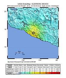
The 2014 Guerrero earthquake occurred with a moment magnitude of 7.2 that hit the state of Guerrero, close to Acapulco, Mexico, on 18 April at 14:27:26.[1][3][4][5] The epicenter occurred 265 kilometers southwest of Mexico City and at a depth of 24 kilometers.[5][6] Thrust motion at shallow depths is what caused the earthquake. This was broadly consistent with a slip on or near the Guerrero Seismic Gap, a boundary between the Cocos and North American plates along the Pacific Coast approximately 200 kilometers long.[2][6][7] The shaking was felt in states as far away as Puebla and Tlaxcala.[4]
Location
The April 2014 earthquake was located just northwest of the rupture area of a 1957 Guerrero earthquake that measured 7.8 on the moment magnitude scale.[6] Since 1975, 23 earthquakes of magnitude 6.0 or greater have occurred within 200 kilometers of the same area as the April 2014 earthquake.[6]
Damage
One person was injured when a wall collapsed in the city of Lazaro Cardenas, Michoacan.[2] 30 homes and a few buildings in Morelia sustained minor damage. At least 700 buildings and over 500 homes were damaged in Guerrero, and 21 homes collapsed. Building and home damage was also reported in capital Mexico City and states Morelos, Tlaxcala, Veracruz, State of Mexico, and Puebla.[2]
Blackouts were reported in Pachuca, Ecatepec, Chimalhuacán, Colonia del Valle, Nezahualcóyotl, Ixtapaluca, Azcapotzalco, Coyoacán, Xochimilco, Tláhuac, Cuauhtémoc, and around the state of Guerrero.[2]
Landslides were reported, including 13 in Guerrero, 1 in Morelos, 1 in Michoacan, and 1 in Tlaxcala.[2]
See also
References
- 1 2 3 4 "M7.5 - 37km N of Tecpan de Galeana, Mexico". United States Geological Survey. 18 April 2014. Retrieved 18 April 2014.
- 1 2 3 4 5 6 7 8 9 10 "Massive earthquake in Guerrero, Mexico". Earthquake-Report.com. 18 April 2014.
- ↑ "Earthquake, Magnitude 7.2 - GUERRERO, MEXICO - 2014 April 18, 14:27:26 UTC". EMSC-CSEM. Retrieved 27 October 2016.
- 1 2 "Powerful earthquake rattles Mexico, shakes buildings". Reuters. Retrieved 18 April 2014.
- 1 2 "Panic as earthquake hits Mexico City". BBC News. Retrieved 18 April 2014.
- 1 2 3 4 "Poster of the Guerrero, Mexico Earthquake of 18 April 2014 - Magnitude 7.2". earthquake.usgs.gov. Retrieved 26 October 2016.
- ↑ Valdes-Gonzales, C. M.; Espindola, V.; Arreola-Manzano, J. (1 December 2013). "Seismicity patterns in the State of Guerrero, Mexico, 1974–2013: Its implication for the Guerrero Seismic Gap". AGU Fall Meeting Abstracts. 22: S22A–01. Bibcode:2013AGUFM.S22A..01V.
External links
- Mexico's Seismological Service
- The International Seismological Centre has a bibliography and/or authoritative data for this event.
- Other earthquakes in the region