Sumbawa
 | |
 Sumbawa | |
| Geography | |
|---|---|
| Location | South East Asia |
| Coordinates | 8°47′S 118°5′E / 8.783°S 118.083°ECoordinates: 8°47′S 118°5′E / 8.783°S 118.083°E |
| Archipelago | Lesser Sunda Islands |
| Area | 15,214.13 km2 (5,874.21 sq mi) |
| Area rank | 57th |
| Highest elevation | 2,850 m (9,350 ft) |
| Highest point | Tambora |
| Administration | |
|
Indonesia | |
| Province | West Nusa Tenggara |
| Demographics | |
| Population | 1,391,340 (2014) |
| Pop. density | 91.45 /km2 (236.85 /sq mi) |
| Ethnic groups | Sumbawa people, Bima people |
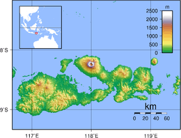
Sumbawa is an Indonesian island, located in the middle of the Lesser Sunda Islands chain, with Lombok to the west, Flores to the east, and Sumba further to the southeast. It is part of the province of West Nusa Tenggara, but there are presently steps being taken by the Indonesian government to turn the island into a separate province.[1] Traditionally the island is known as the source of sappanwood, as well as honey and sandalwood. Its savanna-like climate and vast grasslands are used to breed horses and cattle and to hunt deer.
Sumbawa has an area (including minor offshore islands) of 15,448 square kilometres or 5,965 square miles (three times the size of Lombok) with a current population (January 2014) of around 1.39 million. It marks the boundary between the islands to the west, which were influenced by religion and culture spreading from India, and the region to the east that was less influenced. In particular this applies to both Hinduism and Islam.
History
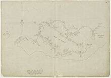
The 14th-century Nagarakretagama mentioned several principalities identified to be on Sumbawa; Dompu, Bima, Sape and one on the Sang Hyang Api island just off the coast of northeast Sumbawa. Four principalities in western Sumbawa were dependencies of the Majapahit Empire of eastern Java. Because of Sumbawa's natural resources, it was regularly invaded by outside forces – from the Javanese, Balinese, Makassar, to the Dutch and Japanese. The Dutch first arrived in 1605, but did not effectively rule Sumbawa until the early 20th century.
For a short period of time, the Balinese kingdom of Gelgel ruled a part of western Sumbawa. The eastern parts of the island, on the other hand, were home to the Sultanate of Bima, an Islamic polity that had links to the Bugis and Makassar peoples of South Sulawesi, as well as other Malay-Islamic polities in the archipelago.
Historical evidence indicates that people on Sumbawa island were known in the East Indies for their honey, horses,[2] sappanwood, which is used to make red dye,[3] and sandalwood, which is used for incense and medications. The area was thought to be highly productive agriculturally.
In the 18th century, the Dutch introduced coffee plantation on the western slopes of Mount Tambora, a volcano on the north side of Sumbawa, thus creating the Tambora coffee variant. Tambora's colossal eruption in 1815 was one of the most powerful of all time, ejecting 150 cubic kilometres (36 cu mi) of ash and debris into the atmosphere. The eruption killed up to 71,000 people and triggered a period of global cooling known as the "Year Without a Summer" in 1816. It also apparently destroyed a small culture of Papuan[4] affinity, known to archaeologists as the "Tambora culture".[5]
Administration
Sumbawa is administratively divided into four regencies (kabupaten) and one kota (city). They are:
| Name | Area in km2. | Population 2005 estimate | Population 2010 Census | Population 2014 estimate | Capital |
|---|---|---|---|---|---|
| Sumbawa Barat (West Sumbawa) Regency | 1,636.95 | 91,882 | 114,754 | 120,115 | Taliwang |
| Sumbawa Regency | 6,643.98 | 395,166 | 415,363 | 434,469 | Sumbawa Besar |
| Dompu Regency | 2,321.55 | 201,842 | 218,984 | 228,811 | Dompu |
| Bima Regency | 4,389.40 | 407,636 | 438,522 | 458,961 | Woha |
| Bima City | 222.25 | 123,064 | 142,443 | 148,984 | Bima |
| Totals | 15,214.13 | 1,219,590 | 1,330,066 | 1,391,340 |
Demographics
Islam, the dominant faith of the island, was introduced by the Makassarese of Sulawesi.
Sumbawa had, historically speaking, three major linguistic groups who spoke languages that were unintelligible to each other. One group centered in the western side of the island speaks Basa Semawa (Indonesian: Bahasa Sumbawa) which is similar to the Sasak language from Lombok; the second group in the east speaks Nggahi Mbojo (Bahasa Bima). They were once separated by the Tambora culture, which spoke a language related to neither. After the demise of Tambora due to the 1815 eruption, local kingdoms based in Sumbawa Besar and Bima became the two focal points of Sumbawa. This division of the island into two parts remains today; Sumbawa Besar and Bima are the two largest towns on the island, and are the centers of distinct cultural groups that share the island.
The population of the island (including minor outliers) was 1.33 million at the latest decennial census in 2010, comprising 29.58%[6] of the population of the entire province's with 4.5 million people.[7] Due to lack of work opportunities on the island and its frequent droughts[8] (unlike wet Bali), many people on the island seek work in the Middle East as laborers or domestic servants; some 500,000 workers, or over 10% of the population of West Nusa Tenggara, have left the country to work overseas.[9]
Geography
The island is bound by bodies of water; to the west is Alas Strait, south is the Indian Ocean, Saleh Bay creates a major north-central indentation in the island, and the Flores Sea runs the length of the northern coastline. The Sape Strait lies to the east of the island and separates Sumbawa from Flores and the Komodo Islands, there are a number bays and gulfs, most notably Bima Bay, Cempi Bay, and Waworada Bay
Sumbawa's most distinguishing features are Saleh Bay and the Sanggar Peninsula. On the latter stands Mount Tambora (8°14’41”S, 117°59’35”E), a large stratovolcano famous for its VEI 7 eruption in 1815, one of only a few eruptions of such magnitude in the last 2,000 years. The eruption obliterated most of Tambora's summit, reducing its height by about a third and leaving a six kilometer-wide caldera. Regardless, Tambora remains the highest point on the island. Highlands rise in four spots on the island, as well as on Sangeang Island. The large western lobe of Sumbawa is dominated by a large central highland, and Tambora, Dompu and Bima each have more minor highlands.
There are a number of large surrounding islands, most notably are Moyo Island, volcanically active Sangeang Island,[10] and the tourist Komodo Islands (administered under Flores) to the east.
List of offshore islands
[11] There are a number of smaller offshore islands which fall within the regencies based on Sumbawa Island:
|
|
|
Economy
Many of the island residents are at risk of starvation when crops fail due to lack of rainfall. The majority of the population works in agriculture. Tourism is very nascent, with a few surf spots renowned for being world class, Jelenga and Supersuck Beaches [11] near the mine, as well as Hu'u and Lakey Beach [11] in the Gulf of Cempi.
Due to the mine, Sumbawa Barat Regency (statistically), along with other remote mining towns, and Jakarta, have the highest GDP per capita rates in Indonesia, Sumbawa Barat's is 156.25 million rupiah ($17,170 USD) as of 2010,[13] yet it is an area that sees entrenched, repeated starvation deaths and severe malnutrition in children.
Newmont Mine
The Southwestern extreme portion of Sumbawa is monopolized by American firm Newmont Mining Corporation; a large gold and copper mine, Newmont's Batu Hijau mine in Sumbawa began commercial operations in 2000, a decade after the copper and gold were discovered.[14] Newmont holds a 45% stake in the operation through its shareholding in PT Newmont Nusa Tenggara. A local unit of Japan's Sumitomo Corporation has a 35% share.
Newmont and its partners have invested about $1.9 billion in the mine. The reserves are expected to last until 2034, making Batu Hijau one of the largest copper mines in the world.
Newmont has been accused of being involved in scandals of mercury and arsenic poisoning in Sulawesi Island,[15] as well as having been embroiled in pollution cases on four continents.[15] Protests on Sumbawa where police fired on protesters of a different gold project did not involve Newmont operations.[16]
Transport
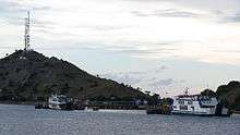
There is a road network in Sumbawa, but it is poorly maintained and has long portions of rough gravel. Frequent ferry service to Sumbawa (Poto Tano) from Lombok (Labuhan Lombok) exists, however ferry service to Flores from Sape is infrequent. Bima is the largest city on Sumbawa and has ferry and bus service directly to Java and Bali, though service breakdowns are common.
The most convenient way to reach Sumbawa is via air. There are commercial flight service connected island's main airport, the Bima airport, to Denpasar and Makassar.
References
- ↑ Jakarta Post, 14 November 2013
- ↑ Jong Boers, B.D. de (2007), ‘The ‘Arab’ of the Indonesian Archipelago: The Famed Horse Breeds of Sumbawa’ in: Greg Bankoff and Sandra Swart (eds), Breeds of Empire: The ‘invention’ of the horse in Southern Africa and Maritime Southeast Asia, 1500–1950. Copenhagen: NIAS Press, pp 51–64.
- ↑ Jong Boers, B.D. de (1997), "Sustainability and time perspective in natural resource management: The exploitation of sappan trees in the forests of Sumbawa, Indonesia (1500–1875)" in: Peter Boomgaard, Freek Colombijn en David Henley (eds), Paper landscapes; Explorations in the environmental history of Indonesia. Leiden: KITLV Press, pp. 260–281.
- ↑ Donohue, Mark (2008-01-03). "The Papuan Language of Tambora". Oceanic Linguistics. 46 (2): 520–537. doi:10.1353/ol.2008.0014. ISSN 1527-9421.
- ↑ Roach, John (February 27, 2006). ""Lost Kingdom" Discovered on Volcanic Island in Indonesia". National Geographic News. National Geographic Society. Retrieved 13 April 2018.
- ↑ (4)
- ↑ "Indonesia (Urban City Population): Provinces & Cities - Statistics & Maps on City Population". Citypopulation.de. Retrieved 15 September 2014.
- ↑ "Local Government Asks People to Be Careful of Drought Hazard Threats". Gaung NTB. March 30, 2010. Archived from the original on March 16, 2012.
- ↑ Frode F. Jacobsen (2009). Hadrami Arabs in Present-day Indonesia: An Indonesia-oriented Group with an Arab Signature. Routledge. p. 30. ISBN 978-1-134-01852-9.
- ↑ "Warum wird diese Seite angezeigt?". Informationsphere.com. Retrieved 18 November 2014.
- 1 2 3 West Nusa Tenggara Map, Provincial Tourism and Cultural Office, West Nusa Tenggara, 2008
- ↑ "Malnourishment 'Not Taken Seriously' as 20 Kids Die in Indonesia's NTB". Jakarta: Jakarta Globe. 2012-10-17. Retrieved 2012-10-21.
- ↑ "Perkembangan Beberapa Indikator, Utama Sosial-Ekonomi, Indonesia" (PDF). Bps.go.id. Retrieved 18 November 2014.
- ↑ Archived October 1, 2011, at the Wayback Machine.
- 1 2 "Spurred by Illness, Indonesians Lash Out at U.S. Mining Giant". The New York Times. September 8, 2004. Retrieved 18 November 2014.
- ↑ "Indonesian police fire on gold mine protesters - ABC News (Australian Broadcasting Corporation)". ABC News. Retrieved 15 September 2014.
External links
| Wikimedia Commons has media related to Sumbawa. |