Pagadian
| Pagadian | ||
|---|---|---|
| Component City | ||
| City of Pagadian | ||
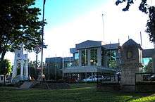
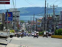 F.S. Pajares Ave. in Pagadian City, showing the view of Illana Bay in the background | ||
| ||
|
Nickname(s): Home of the 40 Degree Tricycle Little Hongkong of the South[1] | ||
| Motto(s): Asenso Pagadian! | ||
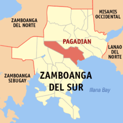 Map of Zamboanga del Sur with Pagadian highlighted | ||
.svg.png) Pagadian Location within the Philippines | ||
| Coordinates: 7°50′N 123°26′E / 7.83°N 123.43°ECoordinates: 7°50′N 123°26′E / 7.83°N 123.43°E | ||
| Country |
| |
| Region | Zamboanga Peninsula (Region IX) | |
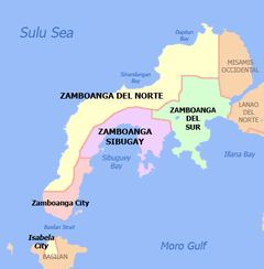
| Province | Zamboanga del Sur | |
| District | 1st District | |
| Founded | March 23, 1937 | |
| Cityhood | June 21, 1969 | |
| Barangays | 54 (see Barangays) | |
| Government [2] | ||
| • Type | Sangguniang Panlungsod | |
| • Mayor | Romeo Pulmones | |
| • Vice Mayor | Ernesto Mondarte | |
| • Electorate | 110,857 voters (2016) | |
| Area [3] | ||
| • Total | 378.8 km2 (146.3 sq mi) | |
| Elevation | 100 m (300 ft) | |
| Highest elevation | 208 m (682 ft) | |
| Population (2015 census)[4] | ||
| • Total | 199,060 | |
| • Density | 530/km2 (1,400/sq mi) | |
| Demonym(s) | Pagadianon | |
| Time zone | UTC+08:00 (PST) | |
| ZIP code | 7016 | |
| PSGC | 097322000 | |
| IDD : area code | +63 (0)62 | |
| Climate type | Tropical climate | |
| Income class | 2nd city income class | |
| Revenue (₱) | 869,862,005.55 (2016) | |
| Native languages |
Subanon language Cebuano Chavacano Tagalog | |
| Catholic diocese | Diocese of Pagadian | |
| Patron saint | Santo Niño de Cebu | |
| Website |
www | |

Pagadian, officially the City of Pagadian, (Filipino: Lungsod ng Pagadian; Chavacano: Ciudad de Pagadian; Cebuano: Dakbayan sa Pagadian), or simply referred to as Pagadian City, is a 2nd class city and the capital of the province of Zamboanga del Sur, Philippines. It is the regional center of Zamboanga Peninsula and the second-largest city in the region, after the independent city of Zamboanga. According to the 2015 census, it has a population of 199,060 people.[4]
Pagadian began as a stop-over for traders who plied the road between the old Spanish fort-town of Zamboanga on the southwestern tip of the Zamboanga Peninsula and other bigger towns to the north of the old Zamboanga Province. Except for its sheltered bay and good fishing grounds, it was not a promising site for the foundation of a city, for it is situated on steeply rolling terrain. In the course of its local history, waves of different kinds of people came to stay, and eventually called among themselves "Pagadianons".
The iconic symbol of Pagadian is its uniquely designed tricycle built to adopt to the city's hilly terrain. It is the only place in the Philippines with a public transport inclined at about 25-40° angle.[5][6][7]
Geography
Pagadian is on the northeastern side of the Western Mindanao region, bordering on Illana Bay. It is bounded by the municipalities of Tigbao and Dumalinao on the southwest, Lakewood on the west, Labangan on the east and northwest, and Midsalip on the north.
About 45% of the total city area is steeply sloping terrain of hills and mountains on the northwestern portion that covers an estimated 15,090 hectares. Mt. Palpalan, Mt. Timolan, Mt. Pinokis, and Mt. Sugar Loaf are the four tallest peaks. Areas in the direct north and central part, have gentle to moderate slopes, making up 47% of the total. The remaining 8% is level or nearly level which makes up most of the eastern and the southern parts of the city. The urban area covers about 845.48 hectares. Elevation of the urban area of the city ranges from 1 MSL (mean sea level) near Pagadian Bay to about 100 MSL in the area of Barangay San Jose.
The Tiguma, Bulatoc, Gatas, and Balangasan Rivers, drain to Pagadian Bay and serve as natural drainage. Due to its topography, most of the city's 54 barangays do not experience flooding. The low-lying southern and eastern part of the city sometimes experience flooding, most especially during heavy rains.
Climate
Located within the tropics of the northern hemisphere, Pagadian has a pronounced dry season from January to March and rainy season from April to December. The area is generally not affected by tropical storms and typhoons as it is located outside the Philippine Typhoon Belt. Temperature ranges from 22.2 to 32.9 °C (72.0 to 91.2 °F). The prevailing winds are the southwest wind that blow from over the sea during dry seasons going northeast, and the trade winds brought from the mountain ranges. Rainfall distribution is moderate from 2,500 to 3,000 millimetres (98 to 118 in) annually.
Barangays
It is politically subdivided into 54 barangays of which 14 of these are classified as urban.
- Urban
- Balangasan
- Dumagoc
- Gatas
- Kawit
- Lumbia
- San Francisco
- San Jose
- San Pedro
- Santa Lucia
- Santa Maria
- Santiago
- Santo Niño
- Tiguma
- Tuburan
- Rural
- Alegria
- Balintawak
- Baloyboan
- Banale
- Bogo
- Bomba
- Buenavista
- Bulatok
- Bulawan
- Camalig
- Dampalan
- Danlugan
- Dao
- Datagan
- Deborok
- Ditoray
- Gubac
- Gubang
- Kagawasan
- Kahayagan
- Kalasan
- La Suerte
- Lala
- Lapidian
- Lenienza
- Lison Valley
- Lourdes
- Lower Sibatang
- Lumad
- Macasing
- Manga
- Muricay
- Napolan
- Palpalan
- Pedulonan
- Poloyagan
- Tawagan Sur
- Tulangan
- Tulawas
- Upper Sibatang
- White Beach
History
Origin of the name
The city proper and surrounding areas of today's barangays of Muricay, Tawagan Sur and White Beach was originally named Talapukan, an indigenous word that means "a place of numerous springs."[8] The officially accepted origin of its name are words taken from the Iranun language, pagad ("to wait") and padian ("market")[8] which shows that Pagadian had been a trading area in the past. Other theories suggest that it was named after a bird that the native inhabitants call gagadian or that the city's name came from the word pangadyi ("prayer"), later to be known as pangadyian ("a place to pray" or "land of prayers"). The name Pagadian is also speculated to be derived from the Subanen word pengadian which means "school".
Early settlers
The native inhabitants in the area were the Lumads, specifically Subanens. Then came Muslim settlers who converted the people to Islam. A sizeable number of lumads who refused to be converted eventually settled in the highlands.
The early Bangsamoro were under the leadership of Datu Akob, an Iranun datu whose daughter caught the fancy of Datu Macaumbang (Sultan of Taga Nonok), also an Iranun from Malabang, Tukuran, also part of modern Pagadian. He was the son of Shariff Apo Tubo who descended from the bloodline of Shariff Kabungsuan, the first Sultan of the Maguindanao Sultanate. With the approval of Sultan Datu Akob, Datu Macaumbang married Bai Putri Panyawan Akob, the beautiful daughter of the royal datu of Pagadian City and royal bai putri of Raya.[9]
Upon the death of Datu Akob also known as Datu Mimbalawag, his son-in-law, Datu Macaumbang (Sultan of taga Nonok) assumed leadership; he established the territorial boundaries of the present city proper, from Balangasan River in the west of Tawagan Sur River in the east. Beyond the river of Tawagan Sur was the territory of Datu Balimbingan. At one time, Datu Macaumbang requested the assistance of the Philippine constabulary due to the rampant banditry and piracy in the area. A detachment led by Col. Tiburcio Ballesteros stationed at Malangas landed at the place and stationed themselves at Dumagoc Island. The arrival of the soldiers restored peace and order, thereby attracting the influx of settlers from other places.[9]
Spread of Christianity
Christian settlers started arriving in the early part of the 20th century, most of which came from Cebu as evident on the veneration of the Santo Niño de Cebú. The increasing Christian population prompted the creation of the Parish of Pagadian in 1938 and was administered by the Jesuits, Columban and Filipino priests. The original Sto. Niño Church of Pagadian was right across the city plaza, on the site of the current San Jose Parish church. The present Sto. Niño Cathedral is now located in San Francisco District and was built in 1968.[10]
Pagadian Parish became a diocese on November 2, 1971, and is a suffragan of the Archdiocese of Ozamiz. Msgr. Jesus B. Tuquib served as the first bishop and was installed on February 24, 1973.[10] At that time, the Columban Fathers took care of the apostolic services for the first 13 parishes in the newly formed diocese.
As of 2008, the Diocese of Pagadian had 24 parishes.[11]
Timeline
| Date/Year | Significant Events |
|---|---|
| pre-1920s | The present-day Pagadian had its beginnings as a sitio of Margosatubig. |
| July 1927 | It became a barrio under the Municipal District of Labangan, Zamboanga upon the implementation of Executive Order no.70.[12] |
| 1934 | The transfer the seat of the Labangan Government to Pagadian was made through the efforts of Director Teofisto Guingona, Sr. who was commissioned by Philippine Governor-General Leonard Wood to find out the possibility of transferring the seat of government of the Labangan municipality to another place. A conference was first held, together with the Datus and the early Christian settlers as the idea of the transfer was at first largely opposed by the Christians. Eventually, a consensus was reached when the designated committee led by Datu Balimbingan of Labangan and with the consent of Datu Macaumbang surveyed the western part of the present area and found Talpokan, a part of the barrio of Pagadian, deemed as a suitable place for such transfer. At the same time, Datu Macaumbang donated 260 hectares of land to Christians who were willing to transfer to the area.[13] |
| March 23, 1937 | Pagadian became a municipality through Executive Order 77 due to the eager initiative of then Assemblyman Juan S. Alano, with the Jose Sanson appointed as acting mayor. The Norberto Bana Sr. was elected as the first officially elected municipal mayor after the regular elections. The Municipality of Pagadian was formed by merging the municipal districts of Labangan and Dinas,[14] as a result, making Labangan a district under its former barrio. The newly created town had 19 barangays or districts.[15] (In 1950 the barrios of Dinas, Legarda, Mirapao, Migpulao, Kalipapa, Pisaan, Bubway, Tiniguangan, Tabina and Dimataling which were under the Municipality of Pagadian, were incorporated into the newly created town of Dimataling.[16] In the same manner, the barrios of Dumalinao Proper, Begong, Nilo, Tigbao, Ticwas, Balongating, Baguitan, Pantad, Napolan, Tagulo, Camanga, Maragang, Sibucao, Tina, Guling, Miculong, Baga, Rebucon, and Mambilik were constituted into Dumalinao in 1956.)[17] |
| World War II | Pagadian was occupied by Japanese troops. From November 5 to November 20, 1944, the combined American and Filipino troops including recognized guerrillas were attempted to take the town from the Japanese. Sixteen Japanese soldiers were killed, but they remained in possession of Pagadian.[18] The establishment of the general headquarters of the Philippine Commonwealth Army and the Philippine Constabulary were stationed in Pagadian and active from November 21, 1944 to June 30, 1946 during and aftermath of World War II and include the military operations and engagements against the Japanese and liberated areas in Mindanao began in November 21, 1944 to August 15, 1945. |
| June 6, 1952 | Congressman Roseller T. Lim authored R.A. 711 dividing Zamboanga into two provinces - Norte (north) and Sur (south). |
| September 17, 1952 | Pagadian became the capital town of the newly established province of Zamboanga del Sur. |
| June 21, 1969 | It became a chartered city through R.A. 5478, becoming the third city in the Zamboanga Peninsula (Administrative Region). |
| August 16, 1976 | The city was one of the hardest hit areas in the Moro Gulf earthquake and tsunami of 1976, considered as the most devastating tsunami disaster in the Philippines in recent times.[19] Pagadian was the major city in the area that was struck by both the earthquake and tsunami and sustained the greatest number of casualties.[19][20] |
| October 1990 | President Corazon Aquino issued the Executive Order 429 that designated Pagadian City as the Regional Center for Region - IX (Zamboanga Peninsula) .[21] |
| November 12, 2004 | Pagadian officially became the Regional Center for Region IX- Zamboanga Peninsula |
| January 22-25, 2017 | Pagadian hosted the 2017 National Schools Press Conference. |
Demographics
| Population census of Pagadian | ||
|---|---|---|
| Year | Pop. | ±% p.a. |
| 1939 | 46,262 | — |
| 1948 | 57,913 | +2.53% |
| 1960 | 41,810 | −2.68% |
| 1970 | 57,615 | +3.25% |
| 1975 | 66,062 | +2.78% |
| 1980 | 80,861 | +4.12% |
| 1990 | 106,307 | +2.77% |
| 1995 | 125,182 | +3.11% |
| 2000 | 142,515 | +2.82% |
| 2007 | 161,312 | +1.72% |
| 2010 | 186,852 | +5.49% |
| 2015 | 199,060 | +1.21% |
| Source: Philippine Statistics Authority[4][22][23][24] | ||
The people of Pagadian (Pagadianons) are classified into three (3) main groups which is based primarily on faith and heritage: (a) The Subanens (or any other indigenous tribes who had been living in the area before the advent of Islam in Mindanao), (b) the Muslim (Bangsamoro) settlers who came from other parts of Mindanao and other places such as Sabah and Indonesia, and (c) the Christian settlers who generally came from the Visayas and Luzon.
Majority of Pagadianons speak the Cebuano language.[25] The national language, Filipino (Tagalog) is widely understood and is the native tongue of a small percentage of the population. Iranun, Maguindanao, Maranao, Tausug, and Samal dialects are used by the Muslim community. The Subanen dialect is exclusively used by the Subanen people, the original inhabitants of the area. Remaining percentage of the population are classified as Hiligaynon and Zamboangueño speakers. As with the rest of the Philippines, English is widely understood and is used as the primary language for business.
Religion
Places of worship in Pagadian:
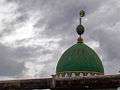 Dome of a mosque in Sta. Lucia District
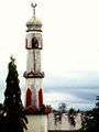 A minaret in Banale, Pagadian City
 Sto. Niño Cathedral
Economy
Agriculture is the primary economic resource, with the production of rice, corn, coconut, fruit, root crops and animal husbandry. Special funding-assistance programs by the government are made available for local farmers; the City Livelihood Development Assistance Program (CILDAP) extends loans to those who need financial assistance for their livelihood.
Production of raw materials like seaweeds, coco processing, cassava constitute a large part of the local economy; small-scale manufacturing of furniture and decors made out of wood, bamboo, rattan, steel and plastic; handicrafts made out of bamboo, rattan, coco shell, wood, marine shell, ceramics, and weaving.
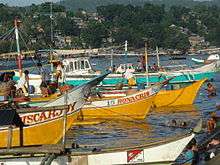
Pagadian Bay and the outer Illana Bay (Iranun Bay) abounds with a wide variety of marine products; seaweed culture farming is flourishing in waters off the bay while fishponds near or along the bay yields milkfish, prawns and crabs. A number of large deep-sea fishing vessels that venture into the Sulu Sea and farther off to South China Sea make Pagadian fishport their base of operation.
Another income-generating industry is mining in an area located 1.5 km southeast of Barangay Lison Valley proper approximately forty-nine kilometers from the city proper which yields gold, copper and molybdenum.
Festivals
The City Fiesta is celebrated every third Sunday of January in honor of its patron saint, the Holy Child Jesus (Sto. Niño) which coincides with the feastday of Cebu City. It is officially called the Pasalamat Festival highlighted with a fluvial parade (regatta), trade exhibits, the Mutya ng Pagadian beauty pageant, carnival shows and a civic military parade. On every 21 June, the Araw ng Pagadian is celebrated in commemoration of its founding as a chartered city; as Capital of Zamboanga del Sur, the city hosts the annual provincial celebration in September with agro-trade exhibits, a civic-military parade, cultural presentations and sports competitions.
The Megayon Festival is a week-long celebration that coincides with the Zamboanga del Sur anniversary in September. It honors the tri-people settlers: the Subanens, BangsaMoro Muslims and Christians.[26] "Megayon" is a Subanen word which means "Unity and Solidarity". The festival is a showcase of three distinctly different cultural heritage in songs, dances, rituals of peace, foods and crafts, to foster unity and understanding among the three cultures. Environment-related activities, peace and development forum, and indigenous sports competitions[27] are being held.
Pagadian City also officially celebrates the Chinese New Year. It honors the local Chinese community.
Places of interest
The city is yet to have a 5-star hotel as it is essentially not a prime tourism get-away, although a recent surge in the hotel and pension-house constructions due to the current influx of visitors primarily to do business in the city is evident, such as the Mardale Hotel and Convention Center.
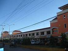
Gaisano Capital Pagadian is the city's biggest mall in terms of land area. C3 Mall (City Commercial Center) is owned by the City Government of Pagadian. It is the site of the old historic "Shopping Center", where the nucleus of Pagadian's trading past is located.
Pagadian City has a number of tourist attractions, though they are not as well known throughout the Philippines.
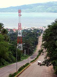
- Pagadian Rotonda. A circular park on top of Bulatoc hill at the apex of the F.S. Pajares Avenue and overlooks the Illana Bay. It is at the intersection of the North Diversion Road and F.S. Pajares Avenue, two of the three major road networks in the city (the third one being Rizal Avenue). The park features a viewing deck, gardens, horseback-riding, and a refreshment store.
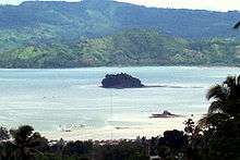
- Dao Dao Islands. The "Dao Dao" name is shared by two islands within the Illana Bay; thus the addition of Dako (big) and Gamay (small) to the names of the islands for simple distinction. "Dao Dao Dako" is the bigger island which covers 1.10 hectares and is a 7 to 10‑minute ride by motorboat from the seaport. It has artificial coral reefs ideal for swimming, boating and fishing. "Dao Dao Gamay" is technically not an island, but a sandbar that partially submerges during high tide.
- Muricay Beach. It is just a little over 4 km from the city proper, swimming is allowed in some parts but is as yet largely underdeveloped. Mangrove and seaweed plantations are nearby.
- Springland Resort. A natural spring water resort, it has three (3) swimming pools and a fishpond. The resort also has a multifunction hall and a restaurant designed in Native Filipino Style.
- Puting Balas. Its name is the literal translation for "white sand" in the local dialect. It is classified as a white sandbar just five minutes via motorboat from northeast of the city seaport.
- Lourdes Waterfalls and Hot and Cold Springs. These are natural hot springs in barangay Lourdes, about 32 km. northwest from the urban area. This is being tapped by the Pagadian City Water District as a water source for barangay Kagawasan.
- Lison Valley Waterfalls is located about 42 km. northwest of Pagadian proper, in sitio Santa Lucia. The falls has a height of about 20–25 meters. The spherical basin, 20 meters in diameter, is ideal for swimming.
- Ditoray Waterfalls is 14 km from the Pagadian poblacion and 5 km from the center of barangay Ditoray.
- Manga Falls and Twin Caves. These natural attractions are located in Barangay Manga, 7 km. from the city proper. A two-layered cascading fall surrounded by huge trees, it is home to monkeys. The twin caves can be explored along the two-layered waterfalls. It is currently in the process of being developed as a tourist spot.
- Kendis Cave is about 14 km from Pagadian poblacion and 5 km from barangay Ditoray and not yet accessible to regular traffic as the only way to reach it is through horseback. The cave has large overhead crevices with two interior chambers.

- Mount Palpalan. The promontory overlooking Pagadian City. Several satellite transmitters and signal towers of television stations and communication networks can be found on its peak. With a height of 684 ft above sea level, it has a sweeping vista of Pagadian City and Illana Bay.
- Mt. Susong Dalaga is the literal translation for "Maiden's Breast" for it is a nearly perfect cone, resembling a maiden woman's breast. It is located in Barangay Lourdes. Mt. Pinokis is located in Barangay Lison Valley.
- Provincial Government Complex. This complex is located in Dao District, a 5-minute ride from downtown Pagadian. The complex has a standard-sized oval track and field and other sports building facilities of which construction is still ongoing and the cultural village with every town of Zamboanga del Sur having its own show-house. The Unity Park, a monument to the Tri-people group (the Lumads, Moslems and Christians) who settled in Pagadian, is located there.
- Plaza Luz. The City's primary public assembly area where the dancing fountain and the Public Library is located. The fountain has recently become the main attraction in the park with its lights and water formations synchronized to the beat of the music being played in its repertoire. Two (2) smaller rectangular fountains run parallel to each other, flanking the circular bigger fountain in the center.
Governance
The city belongs to the 1st District of Zamboanga del Sur. The local Sangguniang Panglungsod (City Legislative Council) is administered by the mayor, with the assistance of the vice mayor. It has ten elected councilors and one representative each from the Sangguniang Kabataan (Youth Council) and Association of Barangay Captains (ABC).
Pagadian is also the seat of the Provincial Government of Zamboanga del Sur.
Infrastructure
Transportation

Tricycles are the primary public transport in the urban center while jeepneys usually ply the city's rural barangays. Private vehicles comprises the largest percentage of the traffic. Buses, minibuses, and jeepneys are the modes of transportation for transients bound for the neighboring municipalities and other parts of Zamboanga del Sur. These short-travel transports also serve the bus terminal which is located downtown.
Airport. The city is served by a Principal Airport Class 1 (or major domestic). It is located in Barangay Muricay and Barangay Tiguma, approximately five (5) kilometers from the city proper.[28] The airport serves as the only air portal in the Province of Zamboanga del Sur with direct flights to and from Manila and Cebu.
Seaport. The port of Pagadian City is served by shipping lines operating for both passenger and cargo vessels. Ports of call include Zamboanga City, Jolo, Siasi, Bongao, Sitangkai and Cotabato City.
Integrated Bus Terminal. Served by two (2) major bus companies and several other smaller Public Utility Vehicles(PUVs), i.e. vans, the terminal sits atop the hill as the station for both Eastbound and Westbound transport particularly for public transports bound for Zamboanga City, Ozamiz City, Dipolog City, Cagayan de Oro, Cotabato City, General Santos City, and Davao City.
Utilities
Telecommunications
Philippine Long Distance Telephone Company (PLDT) and Cruztelco are the two major telecommunications providers. A project under the Department of Transportation and Communications (DOTC), the Pagadian City Telephone Exchange (PACITELEX) serves the far-flung barangays that other telephone companies are not yet able to give service. Major cellular phone service providers in the country serve the city.
Water and power supply
Pagadian City Water District (PCWD) provides the city with potable water supply. Formed in 1976, the PCWD has over 14,000 active service connections and sources its water from deep wells and springs.[29]
Electricity is supplied by the Zamboanga del Sur Electric Cooperative, Incorporated (ZAMSURECO I) from the National Power Corporation Hydro-Electric Plant in Iligan City, sourced from the Maria Cristina Falls. About 77.70% or 42 barangays out of 54 total barangays in the entire city area have 24-hr electricity.
Education
Education institutes in Pagadian include:
- Pagadian City Science High School
- Zamboanga del Sur National High School
- Saint Columban College
- Western Mindanao State University (Esu)
Notable people
- Enrique Ona - Philippine Secretary of Health (2010 - December 19, 2014)
- Antonio Cerilles - former Secretary of Department of Environment and Natural Resources (DENR) during the term of President Joseph Estrada; (from 1998 to 2001); Incumbent Governor of Zambaonga del Sur Province.
Sister cities
- Cooma, New South Wales, Australia[30] - established in 1975 through the Philippine-Australian Development Assistance Programme (PADAP) being with contract with the Snowy Mountains Engineering Corporation, based in the City of Cooma, which undertook development projects within the Province of Zamboanga del Sur.
References
- ↑ "Little Hongkong of the South". Retrieved 2009-03-29.
- ↑ "City". Quezon City, Philippines: Department of the Interior and Local Government. Retrieved 30 May 2013.
- ↑ "Province: Zamboanga del Sur". PSGC Interactive. Quezon City, Philippines: Philippine Statistics Authority. Retrieved 12 November 2016.
- 1 2 3 Census of Population (2015). "Region IX (Zamboanga Peninsula)". Total Population by Province, City, Municipality and Barangay. PSA. Retrieved 20 June 2016.
- ↑ Tourism Philippines (retrieved: 17 July 2012)
- ↑ The Inclined Tricycles of Pagadian City (retrieved: 17 July 2012)
- ↑ My Pagadian.com(retrieved: 31 March 2009)
- 1 2 "Legend of Pagadian City". Pagadian.com. Archived from the original on February 8, 2009. Retrieved 2009-04-26.
- 1 2 The Iranon Tribe Blogspot (retrieved: 29 March 2009)
- 1 2 "History of the Diocese of Pagadian - translated from Cebuano". Pagadian.com. Archived from the original on 2009-05-28. Retrieved 2009-04-26.
- ↑ "Ucan Diocesan Profiles". UCA News. 2009-04-22. Retrieved 2010-07-11.
- ↑ Labangan Teachers, p69. (retrieved: 29 March 2009)
- ↑ 1stphilippines.com - Pagadian History (retrieved: 29 March 2009)
- ↑ History of Zamboanga del Sur, p37-38 (retrieved: 29 March 2009)
- ↑ History of Zamboanga del Sur, p38 (retrieved: 29 March 2009)
- ↑ "An act to create the municipality of Dimataling in the province of Zamboanga". LawPH.com. Archived from the original on 2012-07-12. Retrieved 2011-04-09.
- ↑ "An Act Creating Municipality of Dumalinao in the Province of Zamboanga Del Sur". LawPH.com. Archived from the original on 2012-07-10. Retrieved 2011-04-12.
- ↑ Kent Holmes, Wendell Fertig and His Guerrilla Forces in the Philippines: Fighting the Japanese Occupation (Jefferson, N.C.: 2015), p. 116
- 1 2 "The Philippine Tsunami of 1976". www.drgeorgepc.com. Retrieved 2009-04-26.
- ↑ Phivolcs Report, Earthquake of 1976 Archived 2011-04-27 at the Wayback Machine.(retrieved: 31 March 2009)
- ↑ Philippines Law Online (retrieved: 16 March 2009)
- ↑ Census of Population and Housing (2010). "Region IX (Zamboanga Peninsula)". Total Population by Province, City, Municipality and Barangay. NSO. Retrieved 29 June 2016.
- ↑ Censuses of Population (1903–2007). "Region IX (Zamboanga Peninsula)". Table 1. Population Enumerated in Various Censuses by Province/Highly Urbanized City: 1903 to 2007. NSO.
- ↑ "Province of Zamboanga del Sur". Municipality Population Data. Local Water Utilities Administration Research Division. Retrieved 17 December 2016.
- ↑
- ↑ Unsapa.com - ZamboSur Anniversary (retrieved: 26 April 2009)
- ↑ PIA - Zamboanga del Sur (retrieved: 26 April 2009)
- ↑ CAAP Official Website - About Us Archived 2013-10-30 at the Wayback Machine.
- ↑ Local Water Utilities Administration Website Archived 2009-01-06 at the Wayback Machine.(retrieved: 28 March 2009)
- ↑ City of Pagadian Official Website - Geographical Location(retrieved: 17 July 2012)
External links
| Wikimedia Commons has media related to Pagadian. |
| Wikivoyage has a travel guide for Pagadian. |
- Pagadian City
- Philippine Standard Geographic Code
- Philippine Census Information
- Pagadian City Geography (retrieved: 28 March 2009)
- Pagadian's Website
- Basic Facts for Pagadian
Places adjacent to Pagadian | |
|---|---|