Tarauacá
Coordinates: 08°09′39″S 70°45′57″W / 8.16083°S 70.76583°W
| Tarauacá | ||
|---|---|---|
 Panorama view of Downtown Tarauacá and Rio Blanco | ||
| ||
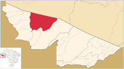 Location of municipality in Acre State | ||
| Coordinates: 08°09′39″S 70°45′57″W / 8.16083°S 70.76583°W | ||
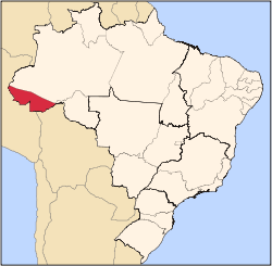
| Country |
| |
| State | Acre | |
| Demonym | tarauacaense | |
| Founded | January 1, 1907 | |
| Government | ||
| • Mayor | Marilete Vitorino (PSD) | |
| Area | ||
| • Total | 6,005.213 sq mi (15,553.430 km2) | |
| Elevation | 551 ft (168 m) | |
| Population (2012) | ||
| • Total | 36,763 | |
| • Density | 6.1/sq mi (2.36/km2) | |
| Postal code | 69970 | |
| Area code(s) | 55-68 | |
Tarauacá is a municipality located in the northwest of the Brazilian state of Acre. Tarauacá has a population of 35,526 people[1] and has an area 20,171 square kilometers (7,788 sq mi).[1]
Conservation
The municipality contains 38% of the Alto Tarauacá Extractive Reserve, created in 2000.[2] It contains the 216,062 hectares (533,900 acres) Rio Gregório State Forest, a sustainable use conservation unit created in 2004.[3] It also contains the 143,897 hectares (355,580 acres) Mogno State Forest and the 126,360 hectares (312,200 acres) Rio Liberdade State Forest, two other sustainable use units created on the same date.[4][5]
Climate
| Climate data for Tarauaca, Acre, Brazil | |||||||||||||
|---|---|---|---|---|---|---|---|---|---|---|---|---|---|
| Month | Jan | Feb | Mar | Apr | May | Jun | Jul | Aug | Sep | Oct | Nov | Dec | Year |
| Average high °C (°F) | 30.9 (87.6) |
30.9 (87.6) |
31.2 (88.2) |
31.0 (87.8) |
30.9 (87.6) |
30.5 (86.9) |
31.4 (88.5) |
32.0 (89.6) |
32.2 (90) |
32.1 (89.8) |
31.5 (88.7) |
31.1 (88) |
31.3 (88.4) |
| Daily mean °C (°F) | 25.3 (77.5) |
25.0 (77) |
25.2 (77.4) |
25.1 (77.2) |
24.8 (76.6) |
23.7 (74.7) |
24.0 (75.2) |
24.4 (75.9) |
24.9 (76.8) |
25.4 (77.7) |
25.5 (77.9) |
25.4 (77.7) |
24.9 (76.8) |
| Average low °C (°F) | 21.9 (71.4) |
21.5 (70.7) |
21.8 (71.2) |
21.6 (70.9) |
21.0 (69.8) |
19.0 (66.2) |
18.8 (65.8) |
19.4 (66.9) |
20.1 (68.2) |
21.1 (70) |
22.0 (71.6) |
22.0 (71.6) |
20.9 (69.5) |
| Average rainfall mm (inches) | 281.7 (11.091) |
271.3 (10.681) |
303.9 (11.965) |
208.3 (8.201) |
129.8 (5.11) |
55.8 (2.197) |
66.7 (2.626) |
74.7 (2.941) |
111.9 (4.406) |
200.0 (7.874) |
207.3 (8.161) |
275.6 (10.85) |
2,187 (86.103) |
| Mean monthly sunshine hours | 89.9 | 75.6 | 93.0 | 99.0 | 130.2 | 150.0 | 192.2 | 167.4 | 135.0 | 136.4 | 114.0 | 108.5 | 1,491.2 |
| Source: HKO [Hong Kong Observatory] (1961-1990) [6] | |||||||||||||
Transportation
Tarauacá is served by José Galera dos Santos Airport.
References
- 1 2 ibge.gov.br
- ↑ RESEX do Alto Tarauacá (in Portuguese), ISA: Instituto Socioambiental, retrieved 2016-08-07
- ↑ FES do Rio Gregório (in Portuguese), ISA: Instituto Socioambiental, retrieved 2016-07-01
- ↑ FES do Mogno (in Portuguese), ISA:Instituto Socoambiental, retrieved 2016-07-01
- ↑ FES do Rio Liberdade (in Portuguese), ISA: Instituto Sociambiental, retrieved 2016-07-01
- ↑ "Climate Statistics for Tarauaca, Acre, Brazil". Retrieved February 24, 2012.
This article is issued from
Wikipedia.
The text is licensed under Creative Commons - Attribution - Sharealike.
Additional terms may apply for the media files.