Tibet Autonomous Region
| Tibet Autonomous Region Xizang Autonomous Region Chinese: 西藏自治区
Tibetan: བོད་རང་སྐྱོང་ལྗོངས། | |
|---|---|
| Autonomous region | |
| Chinese transcription(s) | |
| • Chinese characters |
西藏自治区 (abbreviation: XZ / 藏) |
| • Pinyin |
Xīzàng Zìzhìqū (abbreviation: Zàng) Tsang |
| Tibetan transcription(s) | |
| • Tibetan script | བོད་རང་སྐྱོང་ལྗོངས། |
| • Wylie transliteration | bod rang skyong ljongs |
| • official transcription (PRC) | Poi Ranggyong Jong |
_(%2Ball_claims_hatched).svg.png) Map showing the location of the Tibet Autonomous Region | |
| Named for |
བོད་ (Bö) is the Tibetan name of the Greater Tibet region. 西藏 (Xīzàng) means "Western Tsang", from Manchu "wargi Dzang", from Tibetan Ü-Tsang. Ü and Tsang are subregions of Greater Tibet. "Tibet" is from the word Tibat of disputed origin. |
| Capital (and largest city) | Lhasa |
| Divisions | 5 prefecture-level cities, 2 prefectures, 6 districts, 68 counties, 692 townships |
| Government | |
| • Party Secretary | Wu Yingjie |
| • Government Chairman | Che Dalha |
| Area[1] | |
| • Total | 1,228,400 km2 (474,300 sq mi) |
| Area rank | 2nd |
| Highest elevation (Mount Everest) | 8,848 m (29,029 ft) |
| Population (December 2014)[2] | |
| • Total | 3,180,000 |
| • Rank | 32nd |
| • Density | 2.59/km2 (6.7/sq mi) |
| • Density rank | 33rd |
| Demographics | |
| • Ethnic composition | 90% Tibetan |
| • Languages and dialects | Tibetan, Mandarin Chinese |
| ISO 3166 code | CN-XZ |
| GDP (2017) |
CNY 131.06 billion USD 15 19.41 (31nd) [3] |
| - per capita |
CNY 39,258 USD 5,814 (28th) |
| HDI (2014) | 0.600[4] (medium) (31st) |
| Website |
www |
| Tibet | |||||||||||||||||||||||||||||||||||||||
.svg.png) "Tibet" in Chinese as "Xīzàng" (top) and in Tibetan as "Poi" (bottom) | |||||||||||||||||||||||||||||||||||||||
| Chinese name | |||||||||||||||||||||||||||||||||||||||
|---|---|---|---|---|---|---|---|---|---|---|---|---|---|---|---|---|---|---|---|---|---|---|---|---|---|---|---|---|---|---|---|---|---|---|---|---|---|---|---|
| Chinese | 西藏 | ||||||||||||||||||||||||||||||||||||||
| Hanyu Pinyin | Xīzàng | ||||||||||||||||||||||||||||||||||||||
| Literal meaning | "Western Tsang" | ||||||||||||||||||||||||||||||||||||||
| |||||||||||||||||||||||||||||||||||||||
| Tibet Autonomous Region (TAR) | |||||||||||||||||||||||||||||||||||||||
| Simplified Chinese | 西藏自治区 | ||||||||||||||||||||||||||||||||||||||
| Traditional Chinese | 西藏自治區 | ||||||||||||||||||||||||||||||||||||||
| Hanyu Pinyin | Xīzàng Zìzhìqū | ||||||||||||||||||||||||||||||||||||||
| Literal meaning | "Western Tsang" Autonomous Region | ||||||||||||||||||||||||||||||||||||||
| |||||||||||||||||||||||||||||||||||||||
| Tibetan name | |||||||||||||||||||||||||||||||||||||||
| Tibetan | བོད་ | ||||||||||||||||||||||||||||||||||||||
| |||||||||||||||||||||||||||||||||||||||
The Tibet Autonomous Region (TAR) or Xizang Autonomous Region, called Tibet or Xizang for short (Chinese: 西藏; pinyin: Xīzàng; literally: "Western Tsang"; Mandarin: [ɕí.tsâŋ]; Tibetan: བོད་, Wylie: Bod, ZYPY: 'Poi' , IPA: [pʰø̀ʔ]), is a province-level nominally autonomous region in Southwest China. It was formally established in 1965 to replace the Tibet Area, an administrative division the PRC inherited from the Republic of China (ROC), about five years after the dismissal of the Kashag by the PRC (this is contested) following the 1959 Tibetan uprising, and about 13 years from the Tibet's incorporation into the PRC in 1951.
The current borders of the Tibet Autonomous Region were generally established in the 18th century[5] and include about half of ethno-cultural Tibet. The Tibet Autonomous Region is the second-largest province-level division of China by area, spanning over 1,200,000 km2 (460,000 sq mi), after Xinjiang, and mostly due to its harsh and rugged terrain, is the least densely populated provincial-level division of the PRC.
History
Part of a series on the |
|---|
| History of Tibet |
 |
| See also |
|
|
There is a politically-charged historical debate on the exact nature of relations between Tibet and the Chinese Ming dynasty (1368–1644) and whether the Ming Dynasty had sovereignty over Tibet[6][7][8] after the Mongol conquest of Tibet and Yuan administrative rule in the 13th and 14th centuries. From 1912 to 1950 Tibet was under de jure suzerainty of the Republic of China, however, the difficulties of establishing a new government in the aftermath of the Xinhai Revolution, the fractious Warlord Era, the Chinese Civil War, and the overwhelming Japanese invasion and occupation before and during World War II left the Republic unable to exert any effective administration. Other parts of ethno-cultural Tibet (eastern Kham and Amdo) had been under de jure administration of the Chinese dynastic government since the mid-18th century;[9] today they are distributed among the provinces of Qinghai, Gansu, Sichuan and Yunnan. (See also: Xikang province)
In 1950, the People's Liberation Army marched into Tibet and defeated the Tibetan local army in a battle fought near the city of Chamdo. In 1951, the Tibetan representatives signed a 17-point agreement with the Central People's Government affirming China's sovereignty over Tibet and the incorporation of Tibet. The agreement was ratified in Lhasa a few months later.[10][11] Although the 17-point agreement had provided for an autonomous administration led by the Dalai Lama, a "Preparatory Committee for the Autonomous Region of Tibet" (PCART) was established in 1955 to exclude the Dalai Lama's government and create a system of administration along Communist lines. Under threat of his life from Chinese forces the Dalai Lama fled to India in 1959 and renounced the 17-point agreement. Tibet Autonomous Region was established in 1965, thus making Tibet a provincial-level division of China.
Geography
The Tibet Autonomous Region is located on the Tibetan Plateau, the highest region on earth. In northern Tibet elevations reach an average of over 4,572 metres (15,000 ft). Mount Everest is located on Tibet's border with Nepal.
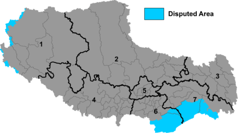
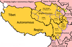
China's provincial-level areas of Xinjiang, Qinghai and Sichuan lie to the north, northeast, and east, respectively, of the Tibet AR. There is also a short border with Yunnan province to the southeast. The PRC has border disputes with the Republic of India over the McMahon Line of Arunachal Pradesh, known to the Chinese as "South Tibet". The disputed territory of Aksai Chin is to the west, and its boundary with that region is not defined. The other countries to the south are Myanmar, Bhutan and Nepal.

Physically, the Tibet AR may be divided into two parts, the lakes region in the west and north-west, and the river region, which spreads out on three sides of the former on the east, south, and west. Both regions receive limited amounts of rainfall as they lie in the rain shadow of the Himalayas, however the region names are useful in contrasting their hydrological structures, and also in contrasting their different cultural uses which is nomadic in the lake region and agricultural in the river region.[12] On the south the Tibet AR is bounded by the Himalayas, and on the north by a broad mountain system. The system at no point narrows to a single range; generally there are three or four across its breadth. As a whole the system forms the watershed between rivers flowing to the Indian Ocean − the Indus, Brahmaputra and Salween and its tributaries − and the streams flowing into the undrained salt lakes to the north.
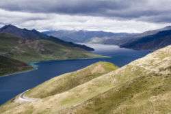
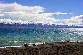
The lake region extends from the Pangong Tso Lake in Ladakh, Lake Rakshastal, Yamdrok Lake and Lake Manasarovar near the source of the Indus River, to the sources of the Salween, the Mekong and the Yangtze. Other lakes include Dagze Co, Namtso, and Pagsum Co. The lake region is a wind-swept Alpine grassland. This region is called the Chang Tang (Byang sang) or 'Northern Plateau' by the people of Tibet. It is some 1,100 km (680 mi) broad, and covers an area about equal to that of France. Due to its great distance from the ocean it is extremely arid and possesses no river outlet. The mountain ranges are spread out, rounded, disconnected, separated by relatively flat valleys.
The Tibet AR is dotted over with large and small lakes, generally salt or alkaline, and intersected by streams. Due to the presence of discontinuous permafrost over the Chang Tang, the soil is boggy and covered with tussocks of grass, thus resembling the Siberian tundra. Salt and fresh-water lakes are intermingled. The lakes are generally without outlet, or have only a small effluent. The deposits consist of soda, potash, borax and common salt. The lake region is noted for a vast number of hot springs, which are widely distributed between the Himalaya and 34° N, but are most numerous to the west of Tengri Nor (north-west of Lhasa). So intense is the cold in this part of Tibet that these springs are sometimes represented by columns of ice, the nearly boiling water having frozen in the act of ejection.
The river region is characterised by fertile mountain valleys and includes the Yarlung Tsangpo River (the upper courses of the Brahmaputra) and its major tributary, the Nyang River, the Salween, the Yangtze, the Mekong, and the Yellow River. The Yarlung Tsangpo Canyon, formed by a horseshoe bend in the river where it flows around Namcha Barwa, is the deepest, and possibly longest canyon in the world.[13] Among the mountains there are many narrow valleys. The valleys of Lhasa, Xigazê, Gyantse and the Brahmaputra are free from permafrost, covered with good soil and groves of trees, well irrigated, and richly cultivated.
The South Tibet Valley is formed by the Yarlung Tsangpo River during its middle reaches, where it travels from west to east. The valley is approximately 1200 kilometres long and 300 kilometres wide. The valley descends from 4500 metres above sea level to 2800 metres. The mountains on either side of the valley are usually around 5000 metres high.[14][15] Lakes here include Lake Paiku and Lake Puma Yumco.
Government
The Tibet Autonomous Region is a province-level entity of the People's Republic of China. Chinese law nominally guarantees some autonomy in the areas of education and language policy. Like other subdivisions of China, routine administration is carried out by a People's Government, headed by a Chairman, who has been an ethnic Tibetan except for an interregnum during the Cultural Revolution. As with other Chinese provinces, the Chairman carries out work under the direction of the regional secretary of the Communist Party of China. The regional standing committee of the Communist Party serves as the top rung of political power in the region. The current Chairman is Che Dalha and the current party secretary is Wu Yingjie.[16]
Administrative divisions
The Autonomous Region is divided into seven prefecture-level divisions: six prefecture-level cities and one prefecture.
These in turn are subdivided into a total of 66 counties and 8 districts (Chengguan, Doilungdêqên, Dagzê, Samzhubzê, Karub, Bayi, Nêdong, and Seni).
| Administrative divisions of Tibet | |||||||||||
|---|---|---|---|---|---|---|---|---|---|---|---|
 Prefecture-level city district areas | |||||||||||
| № | Division code[17] | Division | Area in km2[18] | Population 2010[19] | Seat | Divisions[20] | |||||
| Districts | Counties | ||||||||||
| 540000 | Tibet Autonomous Region | 1,228,400.00 | 3,002,166 | Lhasa city | 8 | 66 | |||||
| 5 | 540,100 | Lhasa city | 29,538.90 | 559,423 | Chengguan District | 3 | 5 | ||||
| 4 | 540,200 | Shigatse / Xigazê city | 182,066.26 | 703,292 | Samzhubzê District | 1 | 17 | ||||
| 3 | 540,300 | Chamdo / Qamdo city | 108,872.30 | 657,505 | Karuo District | 1 | 10 | ||||
| 7 | 540,400 | Nyingchi city | 113,964.79 | 195,109 | Bayi District | 1 | 6 | ||||
| 6 | 540,500 | Shannan / Lhoka city | 79,287.84 | 328,990 | Nêdong District | 1 | 11 | ||||
| 2 | 540,600 | Nagqu city | 391,816.63 | 462,382 | Seni District | 1 | 10 | ||||
| 1 | 542,500 | Ngari Prefecture | 296,822.62 | 95,465 | Gar County | 7 | |||||
| Administrative divisions in Tibetan, Chinese, and varieties of romanizations | |||||
|---|---|---|---|---|---|
| English | Tibetan | Tibetan Pinyin | Wylie transliteration | Chinese | Pinyin |
| Tibet Autonomous Region | བོད་རང་སྐྱོང་ལྗོངས། | Poi Ranggyongjong | bod rang skyong ljongs | 西藏自治区 | Xīzàng Zìzhìqū |
| Lhasa city | ལྷ་ས་གྲོང་ཁྱེར། | Lhasa Chongkyir | lha sa grong khyer | 拉萨市 | Lāsà Shì |
| Xigazê city | གཞིས་ཀ་རྩེ་གྲོང་ཁྱེར། | Xigazê Chongkyir | ggzhis ka rtse grong khyer | 日喀则市 | Rìkāzé Shì |
| Qamdo city | ཆབ་མདོ་གྲོང་ཁྱེར། | Qamdo Chongkyir | chab mdo grong khyer | 昌都市 | Chāngdū Shì |
| Nyingchi city | ཉིང་ཁྲི་གྲོང་ཁྱེར། | Nyingchi Chongkyir | nying khri grong khyer | 林芝市 | Línzhī Shì |
| Shannan city | ལྷོ་ཁ་གྲོང་ཁྱེར། | Lhoka Chongkyir | lho kha grong khyer | 山南市 | Shānnán Shì |
| Nagqu city | ནག་ཆུ་གྲོང་ཁྱེར། | Nagqu Chongkyir | nag chu grong khyer | 那曲市 | àqū Shì |
| Ngari Prefecture | མངའ་རིས་ས་ཁུལ། | Ngari Sakü | mnga' ris sa khul | 阿里地区 | Ālǐ Dìqū |
Urban areas
| Population by urban areas of prefecture & county cities | |||||
|---|---|---|---|---|---|
| # | City | Urban area[21] | District area[21] | City proper[21] | Census date |
| 1 | Lhasa[lower-alpha 1] | 199,159 | 279,074 | 559,423 | 2010-11-01 |
| (1) | Lhasa (new districts)[lower-alpha 1] | 21,093 | 78,957 | see Lhasa | 2010-11-01 |
| 2 | Xigazê[lower-alpha 2] | 63,967 | 120,374 | 703,292 | 2010-11-01 |
| (3) | Qamdo[lower-alpha 3] | 44,028 | 116,500 | 657,505 | 2010-11-01 |
| (4) | Nagqu[lower-alpha 4] | 42,984 | 108,781 | 462,381 | 2010-11-01 |
| (5) | Nyingchi[lower-alpha 5] | 35,179 | 54,702 | 195,109 | 2010-11-01 |
| (6) | Shannan[lower-alpha 6] | 30,646 | 59,615 | 328,990 | 2010-11-01 |
- 1 2 New districts established after census: Doilungdêqên (Doilungdêqên County), Dagzê (Dagzê County). These new districts not included in the urban area & district area count of the pre-expanded city.
- ↑ Xigazê Prefecture is currently known as Xigazê PLC after census; Xigazê CLC is currently known as Samzhubzê after census.
- ↑ Qamdo Prefecture is currently known as Qamdo PLC after census; Qamdo County is currently known as Karuo after census.
- ↑ Nagqu Prefecture is currently known as Nagqu PLC after census; Nagqu County is currently known as Seni after census.
- ↑ Nyingchi Prefecture is currently known as Nyingchi PLC after census; Nyingchi County is currently known as Bayi after census.
- ↑ Shannan Prefecture is currently known as Shannan PLC after census; Nêdong County is currently known as Nêdong after census.
Demography
| Historical population | ||
|---|---|---|
| Year | Pop. | ±% |
| 1912[22] | 1,160,000 | — |
| 1928[23] | 372,000 | −67.9% |
| 1936–37[24] | 372,000 | +0.0% |
| 1947[25] | 1,000,000 | +168.8% |
| 1954[26] | 1,273,969 | +27.4% |
| 1964[27] | 1,251,225 | −1.8% |
| 1982[28] | 1,892,393 | +51.2% |
| 1990[29] | 2,196,010 | +16.0% |
| 2000[30] | 2,616,329 | +19.1% |
| 2010[31] | 3,002,166 | +14.7% |
| Xikang Province / Chuanbian SAR was established in 1923 from parts of Tibet / Lifan Yuan; dissolved in 1955 and parts were incorporated into Tibet AR. | ||
With an average of only two people per square kilometer, Tibet has the lowest population density among any of the Chinese province-level administrative regions, mostly due to its harsh and rugged terrain.[32]
In 2011 the Tibetan population was three million.[33] The ethnic Tibetans, comprising 90.48% of the population,[34] mainly adhere to Tibetan Buddhism and Bön, although there is an ethnic Tibetan Muslim community.[35] Other Muslim ethnic groups such as the Hui and the Salar have inhabited the Region. There is also a tiny Tibetan Christian community in eastern Tibet. Smaller tribal groups such as the Monpa and Lhoba, who follow a combination of Tibetan Buddhism and spirit worship, are found mainly in the southeastern parts of the region.
Historically, the population of Tibet consisted of primarily ethnic Tibetans. According to tradition the original ancestors of the Tibetan people, as represented by the six red bands in the Tibetan flag, are: the Se, Mu, Dong, Tong, Dru and Ra. Other traditional ethnic groups with significant population or with the majority of the ethnic group reside in Tibet include Bai people, Blang, Bonan, Dongxiang, Han, Hui people, Lhoba, Lisu people, Miao, Mongols, Monguor (Tu people), Menba (Monpa), Mosuo, Nakhi, Qiang, Nu people, Pumi, Salar, and Yi people.
According to Encyclopædia Britannica Eleventh Edition published between 1910–1911, total population of Tibetan capital of Lhasa, including the lamas in the city and vicinity, was about 30,000, and the permanent population also included Chinese families (about 2,000).[36]
Most Han people in the TAR (8.17% of the total population)[37] are recent migrants, because all of the Han were expelled from "Outer Tibet" (Central Tibet) following the British invasion until the establishment of the PRC.[38] Only 8% of Han people have household registration in TAR, other keep their household registration in place of origin.[34]
Tibetan scholars and Tibetans in exile claim that, with the 2006 completion of the Qingzang Railway connecting the TAR to Qinghai Province, there has been an "acceleration" of Han migration into the region.[39] The exile Tibetan Administration of the Dalai Lama in north India, claims that the PRC will swamp Tibet with migrants in order to alter Tibet's demographic makeup.[40]
Religion
The main religion in Tibet has been Buddhism since its outspread in the 8th century AD. Before the arrival of Buddhism, the main religion among Tibetans was an indigenous shamanic and animistic religion, Bon, which now comprises a sizeable minority and which would later influence the formation of Tibetan Buddhism.
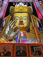
According to estimates from the International Religious Freedom Report of 2012, most of Tibetans (who comprise 91% of the population of the Tibet Autonomous Region) are bound by Tibetan Buddhism, while a minority of 400,000 people (12.5% of the total population of the TAR) are bound to the native Bon or folk religions which share the image of Confucius (Tibetan: Kongtse Trulgyi Gyalpo) with Chinese folk religion, though in a different light.[43][44] According to some reports, the government of China has been promoting the Bon religion, linking it with Confucianism.[45]
Most of the Han Chinese who reside in Tibet practice their native Chinese folk religion (神道; shén dào; "Way of the Gods"). There is a Guandi Temple of Lhasa (拉萨关帝庙) where the Chinese god of war Guandi is identified with the cross-ethnic Chinese, Tibetan, Mongol and Manchu deity Gesar. The temple is built according to both Chinese and Tibetan architecture. It was first erected in 1792 under the Qing dynasty and renovated around 2013 after decades of disrepair.[46][47]
Built or rebuilt between 2014 and 2015 is the Guandi Temple of Qomolangma (Mount Everest), on Ganggar Mount, in Tingri County.[48][49]
There are four mosques in the Tibet Autonomous Region with approximately 4,000 to 5,000 Muslim adherents,[41] although a 2010 Chinese survey found a higher proportion of 0.4%.[42] There is a Catholic church with 700 parishioners, which is located in the traditionally Catholic community of Yanjing in the east of the region.[41]
Towns and villages in Tibet
"Comfortable Housing"
Beginning in 2006, 280,000 Tibetans who lived in traditional villages and as nomadic herdsmen have been forcefully relocated into villages and towns. In those areas new housing was built and existing houses were remodelled to serve a total of 2 million people. Those living in substandard housing were required to dismantle their houses and remodel them to government standards. Much of the expense was borne by the residents themselves often through bank loans. The population transfer program, which was first implemented in Qinghai where 300,000 nomads were resettled, is called "Comfortable Housing". which is part of the “Build a New Socialist Countryside” program. Its effect on Tibetan culture has been criticized by exiles and human rights groups.[50] Finding employment is difficult for relocated persons who have only agrarian skills. Income shortfalls are offset by government support programs.[51] It was announced in 2011 that 20,000 Communist Party cadre were to be placed in the new towns.[50]
Economy
The Tibetans traditionally depended upon agriculture for survival. Since the 1980s, however, other jobs such as taxi-driving and hotel retail work have become available in the wake of Chinese economic reform. In 2011, Tibet's nominal GDP topped 60.5 billion yuan (US$9.60 billion), nearly more than seven times as big as the 11.78 billion yuan (US$1.47 billion) in 2000. Economic growth since the beginning of the 21st century has averaged over 10 percent a year.[32]
While traditional agriculture and animal husbandry continue to lead the area's economy, in 2005 the tertiary sector contributed more than half of its GDP growth, the first time it surpassed the area's primary industry.[52][53] Rich reserves of natural resources and raw materials have yet to lead to the creation of a strong secondary sector, due in large part to the province's inhospitable terrain, low population density, an underdeveloped infrastructure and the high cost of extraction.[32]
The collection of caterpillar fungus (Cordyceps sinensis, known in Tibetan as Yartsa Gunbu) in late spring / early summer is in many areas the most important source of cash for rural households. It contributes an average of 40% to rural cash income and 8.5% to the TAR's GDP.[54]
The re-opening of the Nathu La pass (on southern Tibet's border with India) should facilitate Sino-Indian border trade and boost Tibet's economy.[55]
In 2008, Chinese news media reported that the per capita disposable incomes of urban and rural residents in Tibet averaged 12,482 yuan (US$1,798) and 3,176 yuan (US$457) respectively.[56]
The China Western Development policy was adopted in 2000 by the central government to boost economic development in western China, including the Tibet Autonomous Region.
Tourism
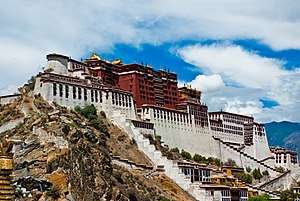
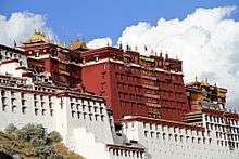
Foreign tourists were first permitted to visit the Tibet Autonomous Region in the 1980s. While the main attraction is the Potala Palace in Lhasa, there are many other popular tourist destinations including the Jokhang Temple, Namtso Lake, and Tashilhunpo Monastery.[57] Nonetheless, tourism in Tibet is still restricted for non-Chinese passport holders and Taiwan citizens, and presently the only way for foreigners to enter is via Tibet Entry Permit. The permit can only be obtained through a travel agency in Tibet, and travel in Tibet must be arranged in a group tour, in which the group must be accompanied by a licensed tour guide at all times. Those traveling into Tibet must specify every location they want to travel within the TAR, and thus cannot travel anywhere not specified in the application. Before entering on a train, plane, or road leading into Tibet, anyone without a Chinese passport must present the Tibet Entry Permit, or they will otherwise be denied entry. Even people coming to Tibet from Nepal must have arranged for the entry permit ahead of time. People barred from obtaining the permit are journalists, diplomats, professional media photographers, and government officials.[58]
Transport
Airports
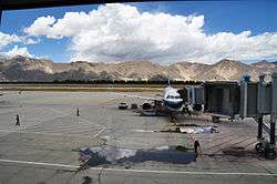
The civil airports in Tibet are Lhasa Gonggar Airport,[59] Qamdo Bangda Airport, Nyingchi Airport, and the Gunsa Airport.
Gunsa Airport in Ngari Prefecture began operations on 1 July 2010, to become the fourth civil airport in China's Tibet Autonomous Region.[60]
The Peace Airport for Xigazê was opened for civilian use on 30 October 2010.[61]
Nagqu Dagring Airport is expected to become the world's highest altitude airport by 2014 at 4,436 meters above sea level.[62]
Railway
The Qinghai–Tibet Railway from Golmud to Lhasa was completed on 12 October 2005. It opened to regular trial service on 1 July 2006. Five pairs of passenger trains run between Golmud and Lhasa, with connections onward to Beijing, Chengdu, Chongqing, Guangzhou, Shanghai, Xining and Lanzhou. The line includes the Tanggula Pass, which, at 5,072 m (16,640 ft) above sea level, is the world's highest railway.
The Lhasa–Xigazê Railway branch from Lhasa to Xigazê was completed in 2014. It opened to regular service on 15 August 2014. The planned China–Nepal railway will connect Xigazê to Kathmandu, capital of Nepal, and is expected to be completed around 2027[63].
The construction of the Sichuan–Tibet Railway began in 2015. The line is expected to be completed around 2025.[64]
See also
References
- ↑ "西藏概况(2007年)" [Overview of Tibet (2007)] (in Chinese). People's Government of Tibet Autonomous Region. 11 September 2008. Archived from the original on 22 December 2015. Retrieved 18 December 2015.
- ↑ "National Data". National Bureau of Statistics of China. Retrieved 18 December 2015.
- ↑ "Statistical Communiqué of Tibet Autonomous Region on the 2017 National Economic and Social Development / 西藏自治区2017年国民经济和社会发展统计公报" (in Chinese). Statistical Bureau of Tibet Autonomous Region. 2018-04-15. Retrieved 2018-06-22.
- ↑ "China National Human Development Report 2016" (PDF). United Nations Development Programme. 2016. p. 146. Retrieved 2017-12-05.
- ↑ "What is Tibet? – Fact and Fancy", Excerpt from Goldstein, Melvyn, C. (1994). Change, Conflict and Continuity among a Community of Nomadic Pastoralist: A Case Study from Western Tibet, 1950–1990. pp. 76–87.
- ↑ Wylie (2003), 470.
- ↑ Wang & Nyima (1997), 1–40.
- ↑ Laird (2006), 106–7.
- ↑ Grunfeld, A. Tom, The Making of Modern Tibet, M.E. Sharpe, p245.
- ↑ Gyatso, Tenzin, Dalai Lama XIV, interview, 25 July 1981.
- ↑ Goldstein, Melvyn C., A History of Modern Tibet, 1913–1951, University of California Press, 1989, p. 812-813.
- ↑ "Tibet: Agricultural Regions". Archived from the original on 24 August 2007. Retrieved 6 August 2007.
- ↑ "The World's Biggest Canyon". china.org. Retrieved 29 June 2007.
- ↑ Yang, Qinye; Zheng, Du (2004). Tibetan Geography. China Intercontinental Press. pp. 30–31. ISBN 7-5085-0665-0.
- ↑ Zheng Du, Zhang Qingsong, Wu Shaohong: Mountain Geoecology and Sustainable Development of the Tibetan Plateau (Kluwer 2000), ISBN 0-7923-6688-3, p. 312;
- ↑ "Leadership shake-up in China's Tibet: state media". France: France 24. Agence France-Presse. 15 January 2010. Archived from the original on 18 January 2010. Retrieved 29 July 2010.
- ↑ "中华人民共和国县以上行政区划代码" (in Chinese). Ministry of Civil Affairs.
- ↑ Shenzhen Statistical Bureau (深圳市统计局).
《深圳统计年鉴2014》 (in Chinese). China Statistics Print (中国统计出版社). Retrieved 2015-05-29. templatestyles stripmarker in
|title=at position 1 (help) - ↑ shi, Guo wu yuan ren kou pu cha ban gong; council, Guo jia tong ji ju ren kou he jiu ye tong ji si bian = Tabulation on the 2010 population census of the people's republic of China by township / compiled by Population census office under the state; population, Department of; statistics, employment statistics national bureau of (2012). Zhongguo 2010 nian ren kou pu cha fen xiang, zhen, jie dao zi liao (Di 1 ban. ed.). Beijing Shi: Zhongguo tong ji chu ban she. ISBN 978-7-5037-6660-2.
- ↑ Ministry of Civil Affairs (August 2014).
《中国民政统计年鉴2014》 (in Chinese). China Statistics Print (中国统计出版社). ISBN 978-7-5037-7130-9. templatestyles stripmarker in
|title=at position 1 (help) - 1 2 3
国务院人口普查办公室、国家统计局人口和社会科技统计司编 (2012). 中国2010年人口普查分县资料. Beijing:
中国统计出版社 [China Statistics Print]. ISBN 978-7-5037-6659-6. templatestyles stripmarker in
|publisher=at position 1 (help); templatestyles stripmarker in|author=at position 1 (help) - ↑ "1912年中国人口". Retrieved 6 March 2014.
- ↑ "1928年中国人口". Retrieved 6 March 2014.
- ↑ "1936–37年中国人口". Retrieved 6 March 2014.
- ↑ "1947年全国人口". Retrieved 6 March 2014.
- ↑ "中华人民共和国国家统计局关于第一次全国人口调查登记结果的公报". National Bureau of Statistics of China. Archived from the original on 5 August 2009.
- ↑ "第二次全国人口普查结果的几项主要统计数字". National Bureau of Statistics of China. Archived from the original on 14 September 2012.
- ↑ "中华人民共和国国家统计局关于一九八二年人口普查主要数字的公报". National Bureau of Statistics of China. Archived from the original on 10 May 2012.
- ↑ "中华人民共和国国家统计局关于一九九〇年人口普查主要数据的公报". National Bureau of Statistics of China. Archived from the original on 19 June 2012.
- ↑ "现将2000年第五次全国人口普查快速汇总的人口地区分布数据公布如下". National Bureau of Statistics of China. Archived from the original on 29 August 2012.
- ↑ "Communiqué of the National Bureau of Statistics of People's Republic of China on Major Figures of the 2010 Population Census". National Bureau of Statistics of China. Archived from the original on 27 July 2013.
- 1 2 3 China Economy @ China Perspective. Thechinaperspective.com. Retrieved on 18 July 2013.
- ↑ Wang, Guanqun. "Tibet's population tops three million; 90% are Tibetans". news.xinhuanet.com. Xinhua. Retrieved 2011-05-04.
- 1 2 "西藏自治区常住人口超过300万". Xizang gov. Xizang gov. Archived from the original on 16 February 2013. Retrieved 6 May 2011.
- ↑ Hannue, Dialogues Tibetan Dialogues Han
- ↑ LHASA (LIIASSA, LASSA,... – Online Information article about LHASA (LIIASSA, LASSA. Encyclopedia.jrank.org. Retrieved on 18 July 2013.
- ↑ Xizang gov. Xizang gov https://web.archive.org/web/20130216101632/http://www.xizang.gov.cn/rkmz/51886.jhtml. Archived from the original on 16 February 2013. Retrieved 6 May 2011. Missing or empty
|title=(help) - ↑ Grunfeld, A. Tom (1996). The Making of Modern Tibet. East Gate Books. pp. 114–119.
- ↑ Johnson, Tim (28 March 2008). "Tibetans see 'Han invasion' as spurring violence | McClatchy". Mcclatchydc.com. Archived from the original on 15 November 2009. Retrieved 11 October 2011.
- ↑ "Population Transfer Programmes". Central Tibetan Administration. 2003. Archived from the original on 30 July 2010. Retrieved 29 July 2010.
- 1 2 3 Internazional Religious Freedom Report 2012 by the US government. p. 20: «Most ethnic Tibetans practice Tibetan Buddhism, although a sizeable minority practices Bon, an indigenous religion, and very small minorities practice Islam, Catholicism, or Protestantism. Some scholars estimate that there are as many as 400,000 Bon followers across the Tibetan Plateau. Scholars also estimate that there are up to 5,000 ethnic Tibetan Muslims and 700 ethnic Tibetan Catholics in the TAR.»
- 1 2 Min Junqing. The Present Situation and Characteristics of Contemporary Islam in China. JISMOR, 8. 2010 Islam by province, page 29. Data from: Yang Zongde, Study on Current Muslim Population in China, Jinan Muslim, 2, 2010.
- ↑ Te-Ming TSENG; Shen-Yu LIN (December 2007). 《臺灣東亞文明研究學刊》第4卷第2期(總第8期) [The Image of Confucius in Tibetan Culture] (PDF). National Taiwan University. pp. 169–207. Archived from the original (pdf) on 4 March 2016.
- ↑ Shenyu Lin. The Tibetan Image of Confucius Archived 13 September 2017 at the Wayback Machine.. Revue d’Etudes Tibétaines.
- ↑ China-Tibet Online: Confucius ruled as a "divine king" in Tibet. 2014-11-04
- ↑ World Guangong Culture: Lhasa, Tibet: Guandi temple was inaugurated.
- ↑ China-Tibet Online: Tibet's largest Guandi Temple gets repaired. 2013-03-13
- ↑ World Guangong Culture: Dingri, Tibet: Cornerstone Laying Ceremony being Grandly Held for the Reconstruction of Qomolangma Guandi Temple.
- ↑ World Guangong Culture: Wuhan, China: Yang Song Meets Cui Yujing to Discuss Qomolangma Guandi Temple.
- 1 2 ""They Say We Should Be Grateful": Mass Rehousing and Relocation Programs in Tibetan Areas of China" (PDF). Human Rights Watch. June 2013. Retrieved 28 June 2013.
- ↑ Jacobs, Andrew (27 June 2013). "Rights Report Faults Mass Relocation of Tibetans". The New York Times. Retrieved 28 June 2013.
- ↑ "Xinhua – Per capita GDP tops $1,000 in Tibet". news.xinhuanet.com. Xinhua. 31 January 2006. Archived from the original on 9 June 2011. Retrieved 11 October 2011.
- ↑ "Tibet posts fixed assets investment rise". news.xinhuanet.com. Xinhua. 31 January 2006. Archived from the original on 9 June 2011. Retrieved 11 October 2011.
- ↑ Winkler D. 2008 Yartsa gunbu (Cordyceps sinenis) and the fungal commodification of rural Tibet. Economic Botany 62.3. See also Hannue, Dialogues Tibetan Dialogues Han
- ↑ Maseeh Rahman in New Delhi (19 June 2006). "China and India to trade across Himalayas | World news". London: The Guardian. Retrieved 11 October 2011.
- ↑ "Tibetans report income rises". news.nen.com.cn. Retrieved 11 October 2011.
- ↑
- Birgit Zotz, Destination Tibet. Hamburg: Kovac 2010, ISBN 978-3-8300-4948-7
- ↑ "In-depth Guide of How to get to Tibet". www.tibettravel.org. Retrieved 2016-01-18.
- ↑ "Gongkhar Airport in Tibet enters digital communication age". Xinhua News Agency. 12 May 2009. Archived from the original on 15 December 2010. Retrieved 12 December 2010.
- ↑ "Tibet's fourth civil airport opens". Xinhua News Agency. 1 July 2010. Archived from the original on 14 December 2010. Retrieved 11 December 2010.
- ↑ "Tibet to have fifth civil airport operational before year end 2010". Xinhua News Agency. 26 July 2010. Archived from the original on 15 December 2010. Retrieved 12 December 2010.
- ↑ "World's highest-altitude airport planned on Tibet". news.xinhuanet.com. Xinhua News Agency. 12 January 2010. Archived from the original on 15 December 2010. Retrieved 12 December 2010.
- ↑ Giri, A; Giri, S (24 August 2018). "Nepal, China agree on rail study". The Kathmandu Post. Retrieved 22 September 2018.
- ↑ Chu. "China Approves New Railway for Tibet". english.cri.cn. CRI. Retrieved 9 November 2014.
Further reading
- Hannue, Dialogues Tibetan Dialogues Han, travelogue from Tibet – by a woman who's been travelling around Tibet for over a decade, ISBN 978-988-97999-3-9
- Sorrel Wilby, Journey Across Tibet: A Young Woman's 1900-Mile Trek Across the Rooftop of the World, Contemporary Books (1988), hardcover, 236 pages, ISBN 0-8092-4608-2.
- Hillman, Ben, ‘China’s Many Tibets: Diqing as a model for ‘development with Tibetan characteristics?’ Asian Ethnicity, Vol. 11, No. 2, June 2010, pp 269–277.
External links
![]()
- Tibet Autonomous Region official website
- Economic profile for Tibet Autonomous Region at HKTDC

- Population Structure and Changes in the Tibet Autonomous Region
| Provinces |  | |
|---|---|---|
| Autonomous regions | ||
| Municipalities | ||
| Special administrative regions | ||
| Other | ||
Note: Taiwan is claimed by the People's Republic of China but administered by the | ||
| Regions |
|  | |||||||
|---|---|---|---|---|---|---|---|---|---|
| Prefectures and counties |
| ||||||||
| |||||||||