Swan Islands, Honduras
 Little Swan Island | |
| Geography | |
|---|---|
| Location | Caribbean Sea |
| Coordinates | 17°24′38″N 83°55′19″W / 17.41056°N 83.92194°WCoordinates: 17°24′38″N 83°55′19″W / 17.41056°N 83.92194°W |
| Archipelago | Bay Islands |
| Area | 3.1 km2 (1.2 sq mi) |
| Administration | |
|
Honduras | |
| Department | Bay Islands |
| Municipality | Islas de la Bahia |
| Demographics | |
| Population | 10 (2014) |
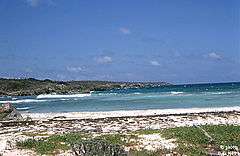
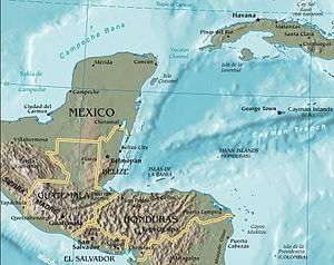
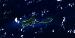
The Swan Islands, or Islas Santanilla or Islas del Cisne, initially named Islas de las Pozas by Christopher Columbus in 1502, is a chain of three islands located in the northwestern Caribbean Sea, approximately 153 kilometres (95 mi) off the coastline of Honduras,[1] with a land area of 3.1 square kilometres (1.2 square miles).[2] The islands are inhabited by a small permanent Honduran navy garrison, located at Great Swan Island.
Geography
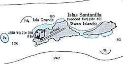
The Swan Islands lie within the exclusive economic zone of Honduras and belong to the Islas de la Bahía department of Honduras.[3] They consist of three islands:
- Great Swan Island (3 km long, 2 km2)
- Little Swan (2.4 km long, 0.5 km wide, 1.2 km2)
- Booby Cay (90 metres long, 70 m off the southwest corner of Great Swan, <0.01 km2)
Rosario Bank and Misteriosa Bank are 130 to 150 km (81–93 mi) north of the Swan Islands and separated from them by the >5,000 m (16,404 ft) deep Cayman Trench.
The islands are uninhabited, except for a small Honduran navy garrison.[1] Great Swan has an airstrip, Islas del Cisne Airport.
History
The Swan Islands were discovered by Christopher Columbus in 1502, and named the 'Islas de las Pozas.' In the 18th Century, they were renamed the Swan Islands, after Captain Swan, who was the captain of the CYGNET, and was captured by pirates and forced to join their ranks.[4]
American entrepreneurs first started exporting guano as a fertilizer in the 1840s. The US-owned, New York-City-headquartered "Atlantic and Pacific Guano Company" was established in the 1840s and started exporting fertilizer, based on guano collected on the Swan Islands. In 1856, the United States apprarently claimed the islands. In April 1857, John Valentine White claimed the islands, based on the Guano Islands Act. Later that year, he transferred all interest in these islands to Charles Sterns, Joseph W. Fabens and Duff Green. These three individuals incorporated the Atlantic and Pacific Guano Company, which issued 50,000 shares at a price of $100 each, for a total capitalization of $5million in 1858.[5] This company even issued currency, signed by William H. Whitfield, in 25 cent, 50 cent and one dollar denominations on June 1, 1867, to facilitate commerce on the islands.[6]
Subsequently, a chemical company bought the islands, became insolvent, and Captain Alonzo Adams sailed there in 1893, and took possession of the islands and in 1904, assigned ownership to the Swan Island Commercial Company. The Swan Island Commercial Company leased part of Great Swan Island to the United Fruit Company to grow coconut palms and set up a wireless radio relay station for servicing their Caribbean fleet, but eventually abandoned this lease. The Swan Island Commercial Company provided hurricane monitoring data from 1928 to 1932. The US Weather Bureau manned a part-time hurricane weather station there from 1938 onward, staffing it only during hurricane seasons.
During World War II, both the U.S. Navy and the U.S. Weather Bureau stationed personnel on the island. In the late 1940s until 1949, Swan Island was set up as a U.S. Department of Agriculture animal quarantine station for the importation of beef. In 1914, the (now named) National Weather Service (NWS) and later, the Federal Aviation Agency (FAA) set up meteorological and communications assets on Swan in support of aeronautical services and hurricane prediction activities. The FAA departed Swan Island in the 1960s, leaving the NWS all assets and responsibilities.
Honduras claimed these islands in 1923, claiming that since Columbus discovered the islands, they should be owned by the nearest Spanish-speaking country. Both the United States and Honduras claimed the Swan Islands until the United States dropped its claim under the Guano Islands Act. A treaty was signed on November 22, 1971, and clear title by Honduras became effective September 1, 1972.[7] The ownership of the island had long been in dispute. The Sumner Smith family has always maintained their ownership and, apparently, did have some standing in the U.S. courts. Still, the U.S. elected to abandon its claim, in spite of this standing (ref. D S Platt, et al., NOAA-NWS). The islands gained attention in the early 1960s due to the activities of Radio Swan, that began broadcasting in May 1960 during preparation for, and during, the abortive Bay of Pigs Invasion of Cuba. The station was removed from the islands in the late 1960s and its main transmitter was transferred for use in the Vietnam War.[8]
In 1965, a former Bellaire High School (Bellaire, Texas) student was questioned by police over his role in a teenage "army" dedicated to freeing "oppressed countries", the Houston Chronicle reported. The group, called the Kononiers, had been in existence for about five years, the student told the paper, and was armed through a series of burglaries of the Deep River Armory store. The weapons were taken to the Addicks Reservoir area, where they trained for combat. Their goal? The youths were training for "Operation Liberation Swan Island" off Honduras.[9]
In 1987, the CIA and other US government agencies were reported by the Los Angeles Times to have a covert training facility for Nicaraguan Contras on Swan Island.[10]
In 1989, the island was declared to be a protected wildlife refuge area by Rafael Leonardo Callejas, the President of Honduras.
In October 1998, Hurricane Mitch moved through the area with winds of 290 km/h (180 mph).[11]
In 2001, Swan Island Development, LLC (Brooksville, FL) announced plans to develop the Swan Islands, in partnership with the Government of Honduras, with luxury real estate and hotels, valued at $5billion, with the main city named Cygnet, by 2010.[12] In 2004, Swan Island Development also announced plans to develop a human stem-cell research center.
See also
References
- 1 2 Zuchora-Walske, Christine (1 August 2009). Honduras in Pictures. Twenty-First Century Books. p. 11. ISBN 978-1-57505-960-0.
- ↑ The area of the islands was measured by the Honduras Statistical Bureau in square kilometres, but a typist mistook the values as being in square miles, so the true size of 3.1 km2 became recorded as 8 km2. Google Earth photos support this.
- ↑ "Islas del Cisne". Glosk.com. Archived from the original on 16 January 2014. Retrieved 15 January 2014.
- ↑ "Brief History". Official Website for the Swan Islands. Retrieved 19 July 2018.
- ↑ "Atlantic and Pacific Guano Company". Scripophily. Retrieved 19 July 2018.
- ↑ "Honduras Swan Island Company 25¢ 1.6.1867 Pick UNL". Heritage Auctions. Retrieved 19 July 2018.
- ↑ United States Treaties and Other International Agreements (in Spanish). 23. Department of State. 1972. p. 2648.
- ↑ "Official Website for the Swan Islands". Retrieved 19 July 2018.
- ↑ Gonzales, J.R. (12 June 2012). "Bellaire Senior High School". Bayou City History. Retrieved 19 July 2018.
- ↑ Miller, Marjorie (15 January 1987). "Honduran Island Used as CIA Base for Contras". Los Angeles Times. Tegucigalpa, Honduras. Retrieved 19 July 2018.
- ↑ Mariners weather log. 43. U.S. Department of Commerce, National Oceanic and Atmospheric Administration, United States National Weather Service, Environmental Data and Information Service. 1999. pp. 1–4.
- ↑ "FantasyInternational.com". AboutUs.com. Retrieved 19 July 2018.