Bohol
{{Infobox settlement
| name = Bohol
| official_name = Province of Bohol
| settlement_type = Province
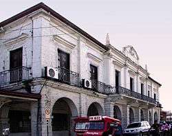
| image_skyline = Bohol Capitol Building Tagbilaran.JPG
| image_caption = Bohol Capitol Building, Tagbilaran
| image_flag = Flag of Bohol Province, Philippines.svg
| flag_size = 120x80px
| image_seal = Bohol Seal 1.svg
| seal_size = 120x80px
| image_shield =
| anthem = Awit sa Bohol Bohol Hymn[1]
| image_map = Ph locator map bohol.png
| map_caption = Location in the Philippines
| coordinates = 9°54′N 124°12′E / 9.9°N 124.2°ECoordinates: 9°54′N 124°12′E / 9.9°N 124.2°E
| subdivision_type = Country
| subdivision_name = Philippines
| subdivision_type1 = Region
| subdivision_name1 = Central Visayas (Region VII)
| established_title = Discovered by the Spanish
Founded
| established_date = 25 March 1565
22 July 1854
| seat_type = Provincial Capital
| seat = Tagbilaran
| government_type = Sangguniang Panlalawigan
| government_footnotes = [2]
| leader_title = Governor
| leader_name = Edgar Chatto
| leader_party = PDP-LABAN
| leader_title1 = Vice governor
| leader_name1 = Dionisio Balite
| leader_title2 = Provincial Board
| leader_name2 =
| area_footnotes = [3] | area_total_km2 = 4,820.95 | elevation_m = 870 | elevation_point = Mount Mayana | population_footnotes = [4] | population_total = 1,313,560 | population_as_of = 2015 census | population_density_km2 = auto | population_blank1_title = Voter (2016)[5] | population_blank1 = 798,768 | population_blank2_title = Language | population_blank2 = | population_demonym = Boholano | demographics_type1 = Divisions | demographics1_title1 = Independent cities | demographics1_info1 = 0 | demographics1_title2 = Component cities
| demographics1_info2 =
| demographics1_title3 = Municipalities | demographics1_info3 = {{Collapsible list | titlestyle = font-weight:normal;text-align:left;background-color:WhiteSmoke; | title = 47
| {{MultiReplace|
- Alburquerque
- Alicia
- Anda
- Antequera
- Baclayon
- Balilihan
- Batuan
- Bien Unido
- Bilar
- Buenavista
- Calape
- Candijay
- Carmen
- Catigbian
- Clarin
- Corella
- Cortes
- Dagohoy
- Danao
- Dauis
- Dimiao
- Duero
- Garcia Hernandez
- Getafe
- Guindulman
- Inabanga
- Jagna
- Lila
- Loay
- Loboc
- Loon
- Mabini
- Maribojoc
- Panglao
- Pilar
- President Carlos P. Garcia
- Sagbayan
- San Isidro
- San Miguel
- Sevilla
- Sierra Bullones
- Sikatuna
- Tagbilaran
- Talibon
- Trinidad
- Tubigon
- Ubay
- Valencia
|%[%[[^%[%]]*Tagbilaran%]%]||plain=false}}
}} | demographics1_title5 = Districts | demographics1_info5 = {{Collapsible list | titlestyle = font-weight:normal;text-align:left;background-color:WhiteSmoke; | title = 3
| {{MultiReplace|
- 1st District of Bohol
- 2nd District of Bohol
- 3rd District of Bohol
|%[%[[^%[%]]%]%]||plain=false}}
}}
| timezone = PST
| utc_offset = +08:00
| postal_code_type = ZIP code
| postal_code = 6300–6346
| area_code_type = IDD : area code
| area_code = +63 (0)38
| iso_code = PH
| blank_name_sec1 = Income class
| blank_info_sec1 = 1st class
| blank7_name_sec1 = Climate type
| blank7_info_sec1 = Tropical monsoon climate
| blank1_name_sec1 = PSGC
| blank1_info_sec1 = 071200000
| website = www
The province of Bohol is a first-class province divided into 3 congressional districts, comprising 1 component city and 47 municipalities.[8] It has 1,109 barangays.[9]
The province is a popular tourist destination with its beaches and resorts.[10] The Chocolate Hills, numerous mounds of brown-coloured limestone formations, are the most popular attraction. The formations can be seen by land (climbing the highest point) or by air via ultralight air tours. Panglao Island, located just southwest of Tagbilaran, is famous for its diving locations and is routinely listed as one of the top ten diving locations in the world. Numerous tourist resorts and dive centers dot the southern beaches. The Philippine tarsier, amongst the world's smallest primates, is indigenous to the island.
A strait separates Bohol from Cebu, and both island provinces share a common language, but the Boholanos retain a conscious distinction from the Cebuanos. Bohol's climate is generally dry, with maximum rainfall between the months of June and October. The interior is cooler than the coast.
It was the home province of Carlos P. Garcia, the eighth president of the Republic of the Philippines (1957–1961) who was born in Talibon, Bohol.[11]
On 15 October 2013, Bohol was devastated by a 7.2 magnitude earthquake whose epicenter was 6 km (3.7 mi) south of Sagbayan town. The earthquake, which also hit southern Cebu, claimed 156 lives altogether and injured 374 people. It also destroyed or damaged a number of Bohol's heritage churches.[12][13]
In 2017, the provincial government began initiating the nomination of the entire province to the UNESCO Global Geoparks Network.[14]
History
Early history
Bohol was first settled by the Eskaya tribe who still inhabit the island today. Their population also was absorbed into the Austronesian/Malayo-Polynesian peoples who later settled the islands and form the majority of the population. The Austronesian people living on Bohol traded with other islands in the Philippines and as far as China and Borneo.
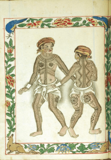
The people of Bohol are said to be the descendants of a group of inhabitants who settled in the Philippines called pintados or "tattooed ones."[15] Boholanos already had a culture of their own as evidenced by artifacts unearthed at Mansasa, Tagbilaran, and in Dauis and Panglao.
Pre-Hispanic Bohol
Bohol's first indigenous people settled in the Anda peninsula. These people came from northeast Mindanao. These people were responsible for the Anda petrographs which are one of the most important indigenous rock writing in the country. Around the 12th century, a group of people from Northern Mindanao settled in the strait between mainland Bohol and the island of Panglao. Those people came from a nation in northern Mindanao called Lutao (probably the animist kingdom of what will soon be the Islamic Lanao). Those people established the kedatuan (kingdom) of Dapitan in western Bohol because the true indigenous people of Bohol in the Anda peninsula and nearby areas were not open to them, forcing them to establish settlement in the western part of the island. They occupied both shores and the entire island of Panglao. The kedatuan was first built with hardwood on the soft seabed. It engaged in trade with nearby areas and some Chinese merchants.[16]
Alcina tales about a rich nation he called the 'Venice of the Visayas', pointing to the kedatuan of Dapitan at that time. A legend tells of a princess named Bugbung Hamusanum, whose beauty caused her suitor, Datung Sumanga, to raid parts of southern China to win her hand.[17]
By 1563, before the full Spanish colonization agenda came to Bohol, the Kedatuan of Dapitan was at war with the Sultanate of Ternate in the Moluccas (who were also raiding the Rajahnate of Butuan). At the time, Dapitan was ruled by two brothers named Dailisan and Pagbuaya. The Ternateans at the time were allied to the Portuguese. Dapitan was destroyed and Datu Dailisan was killed in battle. His brother, Datu Pagbuaya, together with his people fled back to Mindanao and established a new Dapitan in the northern coast of the Zamboanga peninsula. When the Spanish came, the people of Dapitan were influential in the Spanish conquest of the Sultanate of Ternate and in the Christian colonization of northern Mindanao.
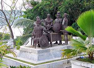
Bohol is derived from the word Bo-ho or Bo-ol.[7] The island was the seat of the first international treaty of peace and unity between the native king Datu Sikatuna and Spanish conquistador Miguel López de Legazpi on 16 March 1565 through a blood compact alliance known today by many Filipinos as the Sandugo.[18]
Spanish colonial period
The earliest significant contact of the island with Spain occurred in 1565. On 25 March (16 March in the Julian calendar), a Spanish explorer named Miguel López de Legazpi arrived in Bohol seeking spices and gold. After convincing the native chieftains that they were not Portuguese (who raided the islands of Mactan in 1521), Legazpi made a peace pact with Datu Sikatuna. This pact was signified with a blood compact between the two men.[19] This event, called the Sandugo ("one blood"), is celebrated in Bohol every year during the Sandugo Festival. The Sandugo or blood compact is also depicted on Bohol's provincial flag and the Bohol provincial seal.[20]
Two significant revolts occurred in Bohol during the Spanish Era. One was the Tamblot Uprising in 1621, led by Tamblot, a babaylan or native priest. The other was the famous Dagohoy Rebellion, considered the longest in Philippine history. This rebellion was led by Francisco Dagohoy, also known as Francisco Sendrijas, from 1744 to 1829.[19]
Politically, Bohol was administered as a residencia of Cebu. It became a separate politico-military province on 22 July 1854 together with Siquijor. A census in 1879 found Bohol with a population of 253,103 distributed among 34 municipalities.[21]
The culture of the Boholanos was influenced by Spain and Mexico during colonization. Many traditional dances, music, dishes and other aspects of the culture have considerable Hispanic influence.
U.S. intervention and occupation
After the United States defeated Spain in the Spanish–American War, the U.S. bought the entire Philippine islands. However, under the newly proclaimed independent government established by Gen. Emilio Aguinaldo, which was not recognized by the U.S., Bohol was governed as a Gobierno de Canton.
During the resulting Philippine–American War, American troops peacefully took over the island in March 1899.[22] However, in January 1901, Pedro Sanson led 2,000 in rebellion, due to the harsh treatment imparted by these troops and the destruction they caused.[22] General Hughes led a campaign of repression in October 1901, destroying a number of towns, and threatening in December 1901 to burn Tagbilaran if the rebels did not surrender.[22] Pantaleon E. del Rosario then negotiated the rebel surrender.[22]
On 10 March 1917, the Americans made Bohol a separate province under Act 2711 (which also established most of the other Philippine provinces).
Japanese occupation and liberation
Japanese troops landed in Tagbilaran on 17 May 1942. Boholanos struggled in a guerilla resistance against the Japanese forces. Bohol was later liberated by the local guerrillas and the Filipino and American troops who landed on 11 April 1945.[23]
A plaque placed on the port of Tagbilaran commemorating the liberation reads:
One thousand one hundred seventy two officers and men of the 3rd Battalion of the 164th Infantry Regiment of the Americal Division under the command of Lt. Col. William H. Considine landed at the Tagbilaran Insular Wharf at 7:00 o'clock in the morning of April 11, 1945.
The convoy taking the Filipino and American liberation forces to Bohol consisted of a flotilla of six landing ships (medium), six landing crafts (infantry), two landing crafts (support), and one landing craft (medium-rocket). Upon arrival, the reinforced battalion combat team advanced rapidly to the east and northeast with the mission of destroying all hostile forces in Bohol. Motor patrols were immediately dispatched by Col. Considine, Task Force Commander, and combed the area to the north and east, approximately halfway across the island, but no enemies were found during the reconnaissance. Finally, an enemy group of undetermined strength was located to the north of Ginopolan in Valencia, near the Sierra-Bullones boundary.
By 17 April the Task Force was poised to strike in Ginopolan. The bulk of the Japanese force was destroyed and beaten in the ten days of action. Bohol was officially declared liberated on 25 May 1945 by Major General William H. Arnold, Commander of the Americal Division. About this time, most officers and men of the Bohol Area Command had been processed by units of the Eighth United States Army.
On 31 May 1945, the Bohol Area Command was officially deactivated upon orders of Lt. General Robert L. Eichelberger, Commanding General of the Eighth United States Army, together with the regular and constable troops of the Philippine Commonwealth Army, Philippine Constabulary, and the Boholano guerrillas.
During the Second Battle of Bohol from March to August 1945, Filipino troops of the 3rd, 8th, 83rd, 85th and 86th Infantry Division of the Philippine Commonwealth Army and 8th Constabulary Regiment of the Philippine Constabulary captured and liberated the island province of Bohol and helped the Boholano guerrilla fighters and U.S. liberation forces defeat the Japanese Imperial forces under General Sōsaku Suzuki.
Recent history
On 12 April 2017, 11 Abu Sayyaf Group (ASG) terrorists staged an attack on Bohol. Three soldiers, a police officer and at least 4 of the armed men, including their leader Abu Rami, were killed in the clashes that started at 5 am. Also killed were two Inabanga villagers, though it was not clear whether they were killed in the crossfire or executed by the cornered militants. Security officials relentlessly hunted down the remainder of the ASG who landed in Bohol from the hinterlands to a neighboring island in the province which ultimately led to the neutralization of Abu Asis, the last of the remaining bandits, in May. He was gunned down by police Special Weapons and Tactics operatives in Barangay Lawis, Calape while fighting it out to the end along with Ubayda. Despite their nefarious intents, all 11 ASG members killed in the intrusion were given proper burials under Muslim tradition.[24][25][26]
The tourism industry in Bohol was negatively affected by the ASG militants' incursion on the island,[27][28] though tour operators believe the industry can recover.[29][30]
Geography
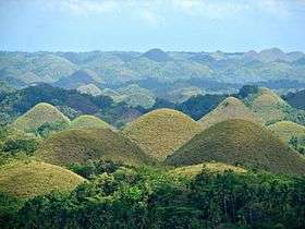
The Chocolate Hills are considered one of Philippine's natural wonders and Bohol is often referred to as the Jewel of the Philippines. They are hills made of limestone left over from coral reefs during the Ice Age when the island was submerged. They turn brown during the summer.
Bohol has 114 springs, 172 creeks, and four main rivers that run through Bohol with a radial drainage pattern.[31] The largest river, the Inabanga River, runs in the northwestern part of the province; the Loboc River drains the center of the island to the mid-southern coast; the Abatan River runs in the southwest, and Ipil River in the north.
Numerous waterfalls and caves are scattered across the island, including Mag‑Aso Falls in Antequera. Mag‑Aso means smoke in the native tongue. The water is cool and often creates a mist in humid mornings which can hide the falls.
The Rajah Sikatuna Protected Landscape protects Bohol's largest remaining lowland forest and can be found in the island's southern portion near Bilar.
Physical
With a land area of 4,821 km2 (1,861 sq mi) and a coastline 261 km (162 mi) long, Bohol is the tenth largest island of the Philippines. The main island is surrounded by about 70 smaller islands, the largest of which are Panglao Island, facing Tagbilaran, in the southwest and Lapinig Island in the northeast.
The terrain of Bohol is basically rolling and hilly, and about half the island is covered in limestone. Near the outer areas of the island are low mountain ranges. The interior is a large plateau with irregular landforms.
Near Carmen, the Chocolate Hills are more than 1,200 uniformly cone-shaped limestone hills named for the grass growing on the hills that turns brown in the summer, making the landscape look like chocolate mounds. The Chocolate Hills appear on the provincial seal of Bohol.
Earthquakes
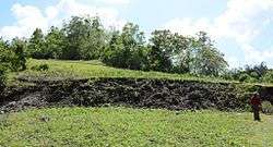
At 8:12 a.m. (PST) on 15 October 2013, the island province suffered a severe earthquake with a magnitude of 7.2 on the Richter scale.[32] Its epicenter was at 9°52′N 124°04′E / 9.86°N 124.07°E (6 km (3.7 mi) S 24° W of Sagbayan and 629 km (391 mi) from Manila), and its depth of focus was 12 km (7.5 mi). The quake was felt as far as Davao City, Mindanao. According to official reports by the National Disaster Risk Reduction and Management Council (NDRRMC), 57 people died in Bohol, and 104 were injured, The Great Wall of Bohol or "North Bohol Fault" is a reverse fault was discovered on 15, October 2013 during the "2013 Bohol earthquake", It became one of the tourist attraction in Bohol province [33]
It was the deadliest earthquake in the Philippines since the 7.8 magnitude 1990 Luzon earthquake.[34] Earlier that same year Bohol was struck by an earthquake (on 8 February 1990) with an epicentre almost exactly the same as in 2013,[35] causing six fatalities and 200 injured. Several buildings were damaged and it caused a tsunami.[36]
Islands
The 75 outlying islands surrounding mainland Bohol under the jurisdiction of the Bohol Provincial Government are:[6]
- Alicia
- Bagatusan
- Bagong Banwa
- Balicasag
- Banacon
- Banbanan
- Bansaan
- Batasan
- Bay Sa Owak
- Bilangbilangan
- Bonbon
- Bosaan
- Buabuahan
- Bugatusan
- Busalian
- Cabilao
- Cabul‑an
- Cabantulan
- Cabgan
- Calangaman
- Cancoslino
- Calituban
- Cataban
- Catang
- Cati‑il
- Cuaming
- Gak‑ang
- Gaus
- Guindacpan
- Hambongan
- Hingutanan
- Inanoran
- Jaguliao
- Jandayan
- Jao
- Juagdan
- Lapinig
- Lapinig Chico (Tres Reyes)
- Limasoc
- Lumislis
- Ma‑agpit
- Mahanay
- Makaina
- Makalingao
- Malingin
- Mantatao Daku
- Mantatao Gamay
- Maomauan
- Maubay
- Mocaboc
- Nasingin
- Nocnocan
- Pamasaun
- Pamilacan
- Pandanon
- Pandao
- Pangangan
- Pangapasan
- Panglao
- Pinango
- Potohan
- Pungtud
- Saag
- Sagasa
- Sandingan
- Sentingnenay
- Silo
- Sinandigan
- Tabangdio
- Talibon
- Talimobo
- Tambo
- Tangtaang
- Tintinan
- Tumok
Tarsier
In 1996 the Philippine Tarsier Foundation was established in Corella, Bohol in efforts to help conserve and protect tarsiers and their habitat. Forest and habitat sanctuaries have been created to ensure the safety of tarsiers while allowing visitors to roam and discover these miniature primates in their natural habitats.
The tarsier is the smallest living primate that exists in several South East Asian countries today. The Philippine tarsier, Tarsius syrichta, locally known as "mamag" in Boholano is near to threatened according to the IUCN Red List of Endangered Species.[37] Adaptation to their large bulging eyes allows them to catch prey clearly at night, and with elongated limbs and fingers, leaping from tree to tree gives no limitation to the tarsier.[38] Their brain is about the same size as their eyes. The connection between its eyes and brain serves a unique function to these animals which is important for their stability and balance.[39] Tarsiers have incredible hearing abilities. They can hear a frequency of up to 91 kHz (kilohertz) and send sounds of 70 kHz.[40]
Climate
From November to April, the northeast monsoon (amihan) prevails. Except for a rare shower, this is the mildest time of the year. Daytime temperatures average 28 °C (82 °F), cooling at night to around 25 °C (77 °F). The summer season from May to July brings higher temperatures and very humid days. From August to October is the southwest monsoon (habagat). The weather during this season is not very predictable, with weeks of calm weather alternating with rainy days. It can rain any day of the year, but a higher chance of heavy showers occurs from November to January.
Administrative divisions
There are 47 municipalities, 1 component city, and 1109 barangays in Bohol.[41]
Demographics
| Population census of Bohol | ||||||||||||||||||||||||||||||||||||||||||||||
|---|---|---|---|---|---|---|---|---|---|---|---|---|---|---|---|---|---|---|---|---|---|---|---|---|---|---|---|---|---|---|---|---|---|---|---|---|---|---|---|---|---|---|---|---|---|---|
|
| |||||||||||||||||||||||||||||||||||||||||||||
| Source: Philippine Statistics Authority[4] [42] [43] [44] | ||||||||||||||||||||||||||||||||||||||||||||||
According to the 2015 census, it has a population of 1,313,560.[4]
Government
Legislative districts
- Governor: Edgardo Migriño Chatto (Liberal Party)
- Vice Governor: Dionisio Balite (PDP-Laban)
|
|
| |||||||||||||||||||||||||||||||||||||||||||||||||||||||||||||||||||||||||||
|
|
|
| |||||||||||||||||||||||||||||||||||||||||||||||||||||||||||||||||||||||||||
| Total 798,768 | |||||||||||||||||||||||||||||||||||||||||||||||||||||||||||||||||||||||||||||
|---|---|---|---|---|---|---|---|---|---|---|---|---|---|---|---|---|---|---|---|---|---|---|---|---|---|---|---|---|---|---|---|---|---|---|---|---|---|---|---|---|---|---|---|---|---|---|---|---|---|---|---|---|---|---|---|---|---|---|---|---|---|---|---|---|---|---|---|---|---|---|---|---|---|---|---|---|---|
History of Governors
| Governors of Bohol |
|---|
| 1. SPANISH PERIOD (from 1854 – 1898) | ||
|---|---|---|
| Guillermo Kirk Patrict | 3 March 1854 – 1857 | First Governor |
| Juan Garcia Navarro | 4 March 1854 – 1859 | |
| Anastacio de Hoyos y Zendegni | 10 March 1859 – 1860 | Bohol was reverted as part of Cebu. Lieutenant Governor was in-charge |
| Herrera Davilla | 1860 | He came to wind up the papers of Bohol |
| Juan Garcia Navarro | 1860 – 1861 | Officially no longer a Governor but empowered to act for matters he started as Governor |
| Jose Diaz Quintana | 1860 – 1864 | Bohol was part of Cebu |
| Antonio Martinez | 1 October 1864 – 1872 | Bohol was again separated from Cebu |
| Don Lemolino | 1872 | Died shortly after assuming office |
| Joaquin Bengoechea | June 1872 – 1878 | |
| Adolfo Martin de Banos | September 1878 – 1882 | |
| Manuel Alcobendes | 1882 – 1883 | |
| Francisco Agusto Linares y Pombo | February 1883 – December 1889 | |
| Adolfo Martin de Banos | 11 December 1889 – 1892 | |
| Eustacio Gonzales Liquiniano | 1892 – 1896 | |
| Eduardo Esteller | 1897 – 1898 | Last Spanish Governor of Bohol |
| 2. REVOLUTIONARY GOVERNOR | ||
|---|---|---|
| Bernabe Fortich Reyes | 1898 – 1900 | First Governor |
| 3. AMERICAN PERIOD | ||
|---|---|---|
| Anecito Velez Clarin | 15 March 1901 – 20 February 1904 | He was appointed because he was not a revolutionary |
| Salustiano Borja | 15 March 1904 – 28 February 1907 | First governor elected under the American Regime |
| 4. PHILIPPINE LEGISLATURE | ||
|---|---|---|
| Macario F. Sarmiento | 1 March 1907 – 31 December 1909 | |
| Fernando G. Rocha | 6 January 1910 – 15 October 1912 | |
| Fernando G. Rocha | 16 October 1912 – 15 October 1916 | Re-elected |
| Eutiquio O. Boyles | 16 October 1916 – 15 October 1919 | |
| Juan Torralba | 16 October 1919 – 20 July 1922 | |
| Juan Torralba | 15 October 1922 – 15 October 1925 | Re-elected |
| Filomeno Orbeta Caseñas | 16 October 1925 – 15 October 1928 | |
| Filomeno Orbeta Caseñas | 16 October 1928 – 15 October 1931 | Re-elected |
| Celestino Barel Gallares | 16 October 1931 – 15 October 1934 | |
| Carlos Polistico Garcia | 16 October 1934 – December 1937 | |
| 5. COMMONWEALTH PERIOD | ||
|---|---|---|
| Carlos Polistico Garcia | 2 January 1938 – 1 January 1941 | Re-elected |
| Agapito Hontanosas | 29 August 1941 – 20 May 1942 | Appointed / Governor under the Japanese |
| Condrado Marapao | 22 May 1942 – 31 May 1946 | Appointed / Governor of the Free Local Government approved by President Manuel Quezon |
| 6. THIRD PHILIPPINE REPUBLIC | ||
|---|---|---|
| Perfecto Balili | 1 June 1946 – 31 December 1947 | Appointed |
| Jacinto Borja | 1 January 1948 – 31 December 1951 | Elected |
| Juan Pajo | 1 January 1952 – 31 December 1953 | Elected |
| Juan Pajo | 1955 – 1957 | Re-elected |
| Esteban Bernido | 4 February 1958 – 1961 | Appointed |
| Esteban Bernido | January 1962 – November 1965 | Elected |
| Esteban Bernido | January 1966 – 7 June 1967 | Re-elected / Resigned - appointed as PHHC manager |
| Lino Ibarra Chatto | 8 June 1967 – December 1968 | Appointed |
| Lino Ibarra Chatto | June 1968 – December 1971 | Elected |
| Lino Ibarra Chatto | 1 January 1972 – 3 March 1978 | Re-elected |
| Esteban Bernido | March 1978 – 12 October 1978 | Appointed |
| Rolando Butalid | 13 October 1978 – 1980 | Appointed |
| Rolando Butalid | January 1981 – 15 March 1986 | Elected |
| Victor dela Serna | 16 March 1986 – 26 October 1987 | OIC |
| Constancio Chatto Torralba | 27 October 1987 – 1 December 1987 | OIC |
| Asterio Akiatan | 2 December 1987 – 1 February 1988 | |
| Constancio Chatto Torralba | 2 February 1988 – 30 June 1992 | Elected |
| David Tirol | 1 July 1992 – 30 June 1995 | Elected |
| Rene Lopez Relampagos | 1 July 1995 – 30 June 1998 | |
| Rene Lopez Relampagos | 1 July 1998 – 30 June 2001 | Re-elected |
| Erico Boyles Aumentado | 1 July 2001 – 30 June 2004 | |
| Erico Boyles Aumentado | 1 July 2004 – 30 June 2007 | Re-elected |
| Erico Boyles Aumentado | 1 July 2007 – 30 June 2010 | Re-elected |
| Edgardo Migriño Chatto | 1 July 2010 – 30 June 2013 | |
| Edgardo Migriño Chatto | 1 July 2013 – | Re-elected |
Economy
Tourism plays an increasing role in the island's economy. The Panglao Island International Airport is currently planned for Panglao, which houses the most-visited and accessible beaches in the province. Proponents of the scheme hope that the new airport will increase Bohol's reputation as an international tourist destination although the plan has been dogged by ongoing criticism.[45]
Infrastructure
Airport
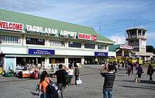
Though a number of national flag carriers serve the Tagbilaran Airport, a proposed international airport (see Panglao Island International Airport) has been planned on nearby Panglao Island to accommodate bigger aircraft and handle larger volumes of passengers and tourists to the province. The Panglao airport project is controversial. Private land in the planned right-of-way that was bought cheaply is being sold expensively, creating further issues and delays.
Seaports
Port of Tubigon, the busiest among the smaller ports, offers more than ten daily round trips plying the Cebu-Bohol route. Catagbacan Port in Loon serves the roll-on roll-off services between Cebu and Bohol for those who have vehicles. Port of Jagna offers service between Bohol to Cagayan and Camiguin (with roll-on/roll-off) route. The other ports are Ubay, Talibon, Getafe, Buenavista, and Clarin.
Media
Bohol has 2 major AM radio stations, DYRD and DYTR, both based in Tagbilaran City. Another AM radio station, DYZD, based in Ubay, is being operated by DYRD. Both DYRD and DYTR also operate FM stations with the same names. There are multiple weekly or twice weekly newspapers like Sunday Post, Bohol Times, Bohol Standard and Bohol Bantay Balita. These days, Bohol Chronicle is now a daily paper. An online news website called Bohol News Daily aggregates news from various sources.
Education
The literacy rate of the province of Bohol is high at 98%.[9]
Institutions of Higher Learning are:
- Bohol Island State University (BISU)
- Holy Name University (HNU)
- University of Bohol (UB)
- BIT International College (BIT-IC)
- Immaculate Heart of Mary Seminary
- Mater Dei College
- ACLC-Tagbilaran
- STI College-Dauis
- PMI Colleges Bohol
- Bohol Wisdom School
- Bohol Northern Star Colleges
- Bohol Northwestern College
- Cristal e-College
- Blessed Trinity College (BTC)
- Batuan Colleges Inc. (BCI)
- Buenavista Community College (BCC)
- Trinidad Municipal College (TMC)
- Asian Divine Light College
- Bohol College of Science and Technology
- Bohol International Learning College (BILC)
Festivals
- Sandugo Festival (1–31 July)
- Tagbilaran City Fiesta (1 May)
- Saulog Tagbilaran Festival in honor to Saint Joseph the Worker
- Bolibong Kingking Festival (23–24 May) – Loboc, Bohol
- Pana-ad sa Loboc (Holy Thursday & Good Friday) – Loboc
- SidlaKasilak or Festival of Lights – Loon (Fiesta Week: 30 August – 8 September)
- Sambat Mascara y Regatta Festival (1st Saturday of December) – Loay, Bohol
- Suroy sa Musikero (25 December 25 – 2 February) – Loboc
- Bohol Fiestas (month of May)
- Ubi Festival (January)[46]
- Tigum Bol-anon Tibuok Kalibutan or TBTK – "A gathering of Boholanos from different parts of the world and the name for such a grand event"[47]
- Hudyaka sa Panglao (27–28 August) Panglao, Bohol
- Sinulog (3rd Saturday of January) – Valencia, Bohol
- Dujan Festival (3rd to last week of January) – Anda
- Sinuog–Estokada Festival (28–29 September) – Jagna
- Chocolate Hills Festival – Carmen
- Alimango Festival – Mabini
- Humay Festival – Candijay
- Guimbawan Festival – Batuan
Notable people
- José Abueva, former president of the University of the Philippines
- Napoleon Abueva, sculptor
- Rich Asuncion, actress
- Cesar Montano, actor
- Rey Bautista, boxer
- Christopher Bernido, physicist, educator, Ramon Magsaysay Awardee
- Tomás Cloma, lawyer and discoverer of the Kalayaan group of islands
- Francisco Dagohoy, revolutionary leader
- Nonito Donaire, boxer
- Bernie Fabiosa, basketball player
- Carlos P. Garcia, the eighth president of the Republic of the Philippines.
- Anna Maris Igpit, beauty pageant contestant in Binibining Pilipinas World
- Rebecca Lusterio actress, born on Balicasag island
- Mark Magsayo, Boxer
- Luke Mejares, singer
- Lauro Mumar, basketball player
- Hannah Precillas, singer and actress
- Cecilio Putong, former education secretary
- Caesar Saloma, applied physicist, chancellor of University of the Philippines Diliman
- Roman "Yoyoy" Villame, singer and composer
Gallery
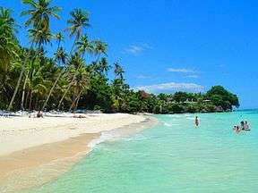 Alona beach
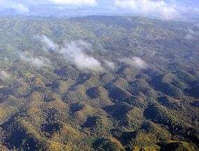 Bohol interior
 Loboc river
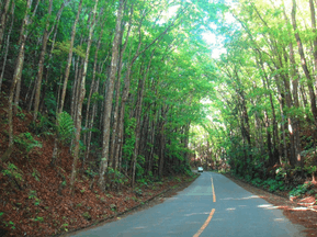 Mahogany forest in Bohol
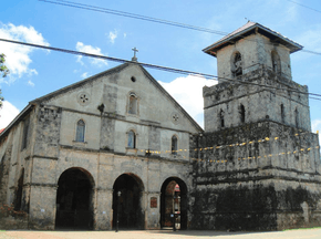 Baclayon church
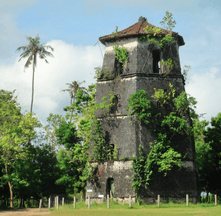 Panglao watchtower
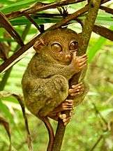 Tarsier
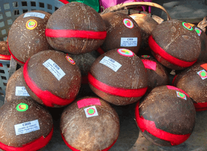 Kalamay delicacy
See also
- Awit sa Bohol - official hymn of the province of Bohol
- Boholano dialect
- Boholano people
- Diocese of Tagbilaran
- Diocese of Talibon
- Eskaya
- Eskayan language
- List of Bohol Churches
- List of Bohol flora and fauna
- List of Bohol-related topics
References
- ↑ Hellingman 2002a.
- ↑ "Province". Quezon City, Philippines: Department of the Interior and Local Government. Retrieved 30 May 2013.
- ↑ "Province: Bohol". PSGC Interactive. Quezon City, Philippines: Philippine Statistics Authority. Retrieved 8 January 2016.
- 1 2 3 Census of Population (2015). "Region VII (Central Visayas)". Total Population by Province, City, Municipality and Barangay. PSA. Retrieved 20 June 2016.
- ↑ "2016 National and Local Elections Statistics". Commission on Elections. 2016.
- 1 2 "Bohol Island Philippines". bohol-philippines.com. Bohol Philippines Travel Guide. Retrieved 20 February 2009.
- 1 2 The Island-Province of Bohol www
.bohol Retrieved 15 November 2006..gov .ph - ↑ NEDA 2000.
- 1 2 "Bohol Profile Executive Brief". Archived from the original on 2006-10-10.
- ↑ Socio-economic Profile www
.bohol .gov .ph - ↑ Bountiful Bohol www
.aenet Retrieved 15 November 2006..org - ↑ Philippines quake hits Cebu and Bohol BBC News. Retrieved on 15 October 2013
- ↑ Powerful quake kills 74 people, destroys heritage churches in Bohol, Cebu GMA News Online. Retrieved on 15 October 2013
- ↑ http://www.boholchronicle.com.ph/2017/10/18/chocolate-hills-positioned-to-be-phs-1st-unesco-global-geopark/
- ↑ Bohol-The Island Province www
.aenet Retrieved 15 November 2006..org - ↑ Blair, Robertson & Vol 40, pp. 105ff.
- ↑ History of the Kingdom of Dapitan. Retrieved 3 February 2017
- ↑ Hellingman 2002b.
- 1 2 Gardner 1997, sourced from Zaide 1949
- ↑ The Bohol Flag and Seal www
.bohol Retrieved November 15, 2006..gov .ph - ↑ History of Bohol www
.bohol Retrieved 15 November 2006..gov .ph - 1 2 3 4 Foreman 1906, p. 528.
- ↑ Hellingman 2002c.
- ↑ Rappler 2017.
- ↑ Philippine Daily Inquirer 2017b.
- ↑ Sun Star 2017.
- ↑ Cebu Daily News 2017a.
- ↑ Cebu Daily News 2017b.
- ↑ Cebu Daily News 2017c.
- ↑ Philippine Daily Inquirer 2017d.
- ↑ Villegas, Ramon N., ed. (2003). Tubod : the heart of Bohol. Manila: National Commission for Culture and the Arts. ISBN 9718140360.
- ↑ "Earthquake Bulletin No. 3: 7.2 Bohol Earthquake". Philippine Institute of Volcanology and Seismology. 15 October 2013. Retrieved 15 October 2013.
- ↑ "SitRep No.2 re Effects of Earthquake in Carmen, Bohol" (PDF). National Disaster Risk Reduction and Management Council. 13 October 2013. Retrieved 15 October 2013.
- ↑ Philippine Daily Inquirer 2013.
- ↑ EERI 1990.
- ↑ New York Times 2013.
- ↑ "Tarsius syrichta (Philippine Tarsier, Phillipine Tarsier)". www.iucnredlist.org. Retrieved 2016-01-27.
- ↑ "Primate Factsheets: Tarsier (Tarsius) Taxonomy, Morphology, & Ecology". pin.primate.wisc.edu. Retrieved 2016-01-27.
- ↑ "Endangered Species International". www.endangeredspeciesinternational.org. Retrieved 2016-01-27.
- ↑ "World's Highest-Pitched Primate Calls Out Like a Bat". LiveScience.com. Retrieved 2016-01-27.
- ↑ "Province: BOHOL". Philippine Standard Geographic Code (PSGC). Quezon City, Philippines: Philippine Statistics Authority. Retrieved 14 February 2017.
- ↑ Census of Population and Housing (2010). "Region VII (Central Visayas)". Total Population by Province, City, Municipality and Barangay. NSO. Retrieved 29 June 2016.
- ↑ Censuses of Population (1903–2007). "Region VII (Central Visayas)". Table 1. Population Enumerated in Various Censuses by Province/Highly Urbanized City: 1903 to 2007. NSO.
- ↑ "Philippines Census Of Population of all LGUs 1903-2007". NCSO.
- ↑ "Bohol Profile on Infrastructure". Government of Bohol. Archived from the original on 10 October 2006.
- ↑ Bohol to hold ubi festival www
.inq7 Retrieved December 4, 2006.net - ↑ Bohol Island Festivals www
.hoteltravel Retrieved November 19, 2006..com
Sources
- Blair, Emma Helen & Robertson, James Alexander, eds. (1906). The Philippine Islands, 1493–1898. Volume 40 of 55 (1690–1691). Historical introduction and additional notes by Edward Gaylord Bourne;. Cleveland, Ohio: Arthur H. Clark Company.
Explorations by early navigators, descriptions of the islands and their peoples, their history and records of the catholic missions, as related in contemporaneous books and manuscripts, showing the political, economic, commercial and religious conditions of those islands from their earliest relations with European nations to the close of the nineteenth century.
- Bohol Chronicle Daily (12 April 2017). "9 killed in PNP, AFP-Abu Sayaff clash". Archived from the original on 9 May 2017.
- Cebu Daily News, Victor Anthony V. Silva (29 April 2017a). "ONE YEAR RECOVERY: ABU SAYYAF in Bohol, the aftermath". Archived from the original on 5 July 2017.
- Cebu Daily News, Cris Evert Lato-Ruffolo, Jose Santino S. Bunachita (25 May 2017b). "Martial law declaration to affect tourism in Cebu, Bohol". Archived from the original on 25 May 2017.
- Cebu Daily News, Victor Anthony V. Silva (7 May 2017c). "Bohol to offer 'fiesta package' to tourists". Archived from the original on 8 May 2017.
- EERI, Jes B. Tirol (1990). "Philippine Earthquake" (PDF). EERI Newsletter. EERI. 24 (6). Archived (PDF) from the original on 8 March 2004.
- Foreman, John (1906). The Philippine Islands. A political, geographical, ethnographical, social and commercial history of the Philippine Archipelago and its political dependencies, embracing the whole period of Spanish rule (3rd ed.). New York: Charles Scribner's Sons. OCLC 3567688.
- Gardner, Robert (1997). "Readings From Bohol's History". Bountiful Bohol. Archived from the original on 1 July 2001.
- Hellingman, Jeroen (2002). "Provincial Symbols of Bohol". Bohol.ph. Archived from the original on 11 August 2015.
- Hellingman, Jeroen (2002). "A Short History of Bohol (Part I)". Bohol.ph. Archived from the original on 20 December 2016.
- Hellingman, Jeroen (2002). "A Short History of Bohol (Part II)". Bohol.ph. Archived from the original on 29 March 2016.
- NEDA (2000). "Region VII". Archived from the original on 19 September 2000.
- New York Times, Floyd Whaley (14 October 2013). "Major Earthquake Strikes Central Philippines". Archived from the original on 2013-10-18.
- Philippine Daily Inquirer, Jeannette I. Andrade (15 October 2013). "Bohol earthquake strongest to hit Visayas and Mindanao in over 20 years". Archived from the original on 15 October 2013.
- Philippine Daily Inquirer (15 April 2017). "Security officials: Bohol attack staged by IS-linked extremists". Archived from the original on 9 May 2017.
- Philippine Daily Inquirer, Leo Udtohan (12 May 2017b). "Soldiers hunting down 2 Abu Sayyaf bandits on island in Bohol". Archived from the original on 12 May 2017.
- Philippine Daily Inquirer, Benjie Talisic, Nestle L. Semilla, Victor Anthony V. Silva (16 May 2017c). "Bohol tourism to go full swing". Archived from the original on 17 May 2017.
- Rappler, Bea Cupin (5 May 2017). "Abu Sayyaf member captured in Bohol". Archived from the original on 5 July 2017.
- Sun Star, PNA (21 May 2017). "Septuagenarian engages Sayyaf bandit in hand-to-hand combat in Bohol". Archived from the original on 21 May 2017.
- Villegas, Ramon N., ed. (2003). Tubod : The Heart of Bohol. National Commission for Culture and the Arts. ISBN 978-9718140369.
- Zaide, Gregorio F. (1949). The Philippines since pre-Spanish times. Philippine Political and Cultural History. I. Philippine Education.
Further reading
- Cajes, Alan S. (2004). "A Brief History of Bohol". Archived from the original on 12 April 2004.
- Tirol, Jes Belarmino (9 January 2011). "TOPONYMS OF BOHOL AND ITS TOWNS Part 1". Bohol Chronicle. Archived from the original on 15 January 2011.
External links
- Official website of the provincial government of Bohol
- Provincial Planning and Development Office of Bohol (includes provincial atlas)
Places adjacent to Bohol | ||||||||||
|---|---|---|---|---|---|---|---|---|---|---|
| ||||||||||


