Nagano (city)
| Nagano 長野市 | |||
|---|---|---|---|
| Core city | |||
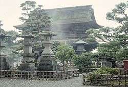
 From top of left, Zenkoji, Mount Togakushi, Kinasa village, Nagano Big Hat arena, Airial in Kawanakajima, Oku-Subana Valley, Marukome, which headquarter in Nagano, and famous for miso product company in Japan, Oyaki Japanese sweets, Togakushi ski place, and Matsushiro Castle | |||
| |||
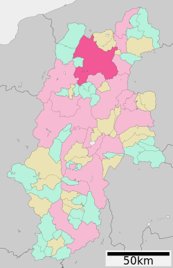 Location of Nagano in Nagano Prefecture | |||
 Nagano | |||
| Coordinates: 36°38′54.9″N 138°11′39.1″E / 36.648583°N 138.194194°ECoordinates: 36°38′54.9″N 138°11′39.1″E / 36.648583°N 138.194194°E | |||
| Country | Japan | ||
| Region | Chūbu (Kōshin'etsu) | ||
| Prefecture | Nagano | ||
| Government | |||
| • - Mayor | Hisao Katō | ||
| Area | |||
| • Total | 834.81 km2 (322.32 sq mi) | ||
| Population (October 2016) | |||
| • Total | 375,234[1] | ||
| • Density | 449/km2 (1,160/sq mi) | ||
| Time zone | UTC+9 (Japan Standard Time) | ||
| Symbols | |||
| • Tree | Japanese Lime | ||
| • Flower | Apple | ||
| Phone number | 026-226-4911 | ||
| Address | 1613 Midori-chō, Nagano-shi, Nagano-ken 380-8512 | ||
| Website | www.city.nagano.nagano.jp | ||


Nagano (長野市 Nagano-shi, Japanese: [nagꜜano]) is the capital city of Nagano Prefecture in the Chūbu region of Japan. As of October 1, 2016, the city had an estimated population of 375,234, and a population density of 449 persons per km². Its total area is 834.81 square kilometres (322.32 sq mi).
History
Nagano is located in former Shinano Province and developed from the Nara period as a temple town at the gate of the famous Zenkō-ji, a 7th-century Buddhist temple which was relocated to this location in 642 AD, and as a post station on the Hokkoku Kaidō highway connecting Edo with the Sea of Japan coast. During the Sengoku period, the area was hotly contested between the forces of the Uesugi clan based in Echigo Province and the Takeda clan based in Kai Province. The several Battles of Kawanakajima between Uesugi Kenshin and Takeda Shingen were fought near here. During the Edo period, much of the area came under the control of the Sanada clan based at Matsushiro Domain. The area suffered from flooding in 1742, and from a destructive earthquake in 1847. Following the Meiji restoration and the creation of the municipalities system on April 1, 1889, the modern town of Nagano was established. Nagano was elevated to city status on April 1, 1897. It was the first city founded in Nagano Prefecture and the 43rd city in Japan.
The city borders expanded on July 1, 1923, with the annexation of the neighbouring town of Yoshida and villages of Sarita, Miwa and Komaki. During World War II, construction of the Matsushiro Underground Imperial Headquarters as the last redoubt for the Japanese government following the projected American invasion of Japan was started in 1944, but was aborted in 1945 due to the end of war.
The city again expanded on April 1, 1954 by annexing neighbouring villages of Asahi, Furusato, Yanagihara, Wakatsuki, Asakawa, Naganuma, Amori, Odagiri, Imoi and Mamejima. In 1959, due to the flooding of Chikuma River, 71 people died or were missing and 20,000 homes were flooded.
On October 16, 1966, the city again expanded by annexing the neighbouring towns of Kawanakajima, Matsushiro and Wakaho, and villages of Shinonoi, Kohoku, Shinko, and Naniai. During the 1985 Matsushiro earthquake, 27 people died and 60 homes were destroyed or badly damaged due to landslides.
In 1998, Nagano hosted the 1998 Winter Olympics and the Paralympics. It was elevated to a core city with increased local autonomy in 1999.
Nagano continued to expand on January 1, 2005, by absorbing the municipalities of Toyono, and the village of Togakushi, and Kinasa (from Kamiminochi District), and the village of Ōoka (from Sarashina District).
Nagano hosted the 2005 Special Olympics World Winter Games.
On January 1, 2010, Nagano absorbed the town of Shinshūshinmachi and the village of Nakajō from Kamiminochi District.[2]
1998 Winter Olympics and Paralympics
Nagano hosted the 1998 Winter Olympics and Paralympics, the third Olympic Games and second winter Olympics to be held in Japan, after the Tokyo 1964 Summer Olympics and the 1972 Winter Olympics in Sapporo (the first Winter Games ever held in Asia). As of 2018, Nagano was the southernmost host of the Winter Olympic Games. The Nagano Olympic Commemorative Marathon is held annually to commemorate the occasion.
Geography
Nagano is located in north-central Nagano Prefecture, near the confluence of the Chikuma River and the Sai River.
Surrounding municipalities
Climate
Nagano has a Hot-summer humid continental climate (Köppen climate classification Dfa) that borders on a humid subtropical climate (Köppen climate classification Cfa). Its location in a sheltered inland valley means it receives less precipitation than any part of Japan except Hokkaidō. The city receives heavy winter snow totaling 2.57 metres (101 in) from December to March, but it is less gloomy during these cold months than the coast from Hagi to Wakkanai.
| Climate data for Nagano, Nagano (1981–2010) | |||||||||||||
|---|---|---|---|---|---|---|---|---|---|---|---|---|---|
| Month | Jan | Feb | Mar | Apr | May | Jun | Jul | Aug | Sep | Oct | Nov | Dec | Year |
| Record high °C (°F) | 18.1 (64.6) |
22.5 (72.5) |
24.4 (75.9) |
30.8 (87.4) |
32.6 (90.7) |
35.6 (96.1) |
37.9 (100.2) |
38.7 (101.7) |
36.3 (97.3) |
32.2 (90) |
26.2 (79.2) |
21.3 (70.3) |
38.7 (101.7) |
| Average high °C (°F) | 3.5 (38.3) |
4.7 (40.5) |
9.5 (49.1) |
17.3 (63.1) |
22.5 (72.5) |
25.7 (78.3) |
29.1 (84.4) |
31.0 (87.8) |
25.6 (78.1) |
19.2 (66.6) |
13.0 (55.4) |
6.8 (44.2) |
17.3 (63.1) |
| Daily mean °C (°F) | −0.6 (30.9) |
0.1 (32.2) |
3.8 (38.8) |
10.6 (51.1) |
16.0 (60.8) |
20.1 (68.2) |
23.8 (74.8) |
25.2 (77.4) |
20.6 (69.1) |
13.9 (57) |
7.5 (45.5) |
2.1 (35.8) |
11.9 (53.4) |
| Average low °C (°F) | −4.1 (24.6) |
−3.8 (25.2) |
−0.8 (30.6) |
4.9 (40.8) |
10.5 (50.9) |
15.8 (60.4) |
20.0 (68) |
21.3 (70.3) |
16.9 (62.4) |
9.7 (49.5) |
3.1 (37.6) |
−1.6 (29.1) |
7.7 (45.9) |
| Record low °C (°F) | −17.0 (1.4) |
−16.4 (2.5) |
−14.6 (5.7) |
−6.5 (20.3) |
−1.8 (28.8) |
3.9 (39) |
10.2 (50.4) |
10.7 (51.3) |
5.5 (41.9) |
−1.9 (28.6) |
−11.4 (11.5) |
−15.2 (4.6) |
−17.0 (1.4) |
| Average precipitation mm (inches) | 51.1 (2.012) |
49.8 (1.961) |
59.4 (2.339) |
53.9 (2.122) |
75.1 (2.957) |
109.2 (4.299) |
134.4 (5.291) |
97.8 (3.85) |
129.4 (5.094) |
82.8 (3.26) |
44.3 (1.744) |
45.5 (1.791) |
932.7 (36.72) |
| Average snowfall cm (inches) | 98 (38.6) |
82 (32.3) |
27 (10.6) |
3 (1.2) |
0 (0) |
0 (0) |
0 (0) |
0 (0) |
0 (0) |
0 (0) |
2 (0.8) |
45 (17.7) |
257 (101.2) |
| Average precipitation days (≥ 0.5 mm) | 13.0 | 11.5 | 12.0 | 9.2 | 10.0 | 11.4 | 13.1 | 9.8 | 11.7 | 9.1 | 8.6 | 10.4 | 129.8 |
| Average snowy days | 22.9 | 19.6 | 8.2 | 0.6 | 0.0 | 0.0 | 0.0 | 0.0 | 0.0 | 0.0 | 0.9 | 10.8 | 63 |
| Average relative humidity (%) | 78 | 74 | 68 | 61 | 64 | 70 | 74 | 72 | 74 | 75 | 76 | 77 | 72 |
| Mean monthly sunshine hours | 127.2 | 131.3 | 168.5 | 198.3 | 207.3 | 162.2 | 168.8 | 204.3 | 141.7 | 152.4 | 139.1 | 135.6 | 1,936.7 |
| Source #1: Japan Meteorological Agency[3] | |||||||||||||
| Source #2: Japan Meteorological Agency (records)[4] | |||||||||||||
Education
Universities and colleges
Nagano is home to several private and public universities. Four of the ten universities recognized as major universities in the prefecture have campuses in the city, including the newest prefectural university, The University of Nagano.[5]
- Shinshu University
- Seisen Jogakuin College
- Nagano Prefectural College
- Seisen Jogakuin College (Junior College)
- Nagano Women's Junior College
- Nagano College of Economics
- Nagano University of Health and Medicine
- National Institute of Technology, Nagano College
- The University of Nagano
Primary and secondary education
Nagano has 55 public elementary schools and 24 public middle schools operated by the city government, along with one public middle school operated by the national government and four private middle schools. The city has 12 public high schools operated by the Nagano Prefectural Board of Education, one public high school operated by the city government, and five private high schools. In addition, the city has four special education schools.
Transportation
Railway
The city's main railway hub, Nagano Station, and the smaller Shinonoi Station, were expanded for the Olympics. The Hokuriku Shinkansen opened in 1997 (initially named the "Nagano Shinkansen"), connecting Nagano to Takasaki, Gunma.
- JR East - Hokuriku Shinkansen
- JR East - Shin'etsu Main Line
- Shinonoi - Imai - Kawanakajima - Amori - Nagano
- JR East - Shinonoi Line
- JR East - Iiyama Line
- Shinano Railway - Kita-Shinano Line
- Nagano - Kita-Nagano - Sansai - Toyono
- Shinano Railway - Shinano Railway Line
- Nagano Electric Railway
- Nagano - Shiyakushomae - Gondo - Zenkojishita - Hongō - Kirihara - Shinano-Yoshida - Asahi - Fuzokuchugakumae - Yanagihara
Bus
Buses for Kawanaka-jima Bus and the Nagano Dentetsu Bus Co. service the city, departing both Nagano Station and the Nagano Bus Terminal just west of the station. Local bus provider, Alpico Kōtsū, departs from a dedicated office across the street from the Zenkō-ji Exit of Nagano Station. Long-distance highway bus services depart from the East Exit of Nagano Station. There is also a daily bus to Narita Airport.
Airport
The nearest airport is Matsumoto Airport, connected via a 70-minute express bus from Nagano City.
Highways
International relations


Local attractions
Nagano is surrounded by mountains which boast excellent hiking, camping, and cycling.
- Zenkō-ji Buddhist temple and pilgrimage destination
- Matsushiro Castle, with its surrounding castle town, preserving many samurai residences, temples, and gardens of the Edo period
- Togakushi Shrine, a complex of five Shinto shrines whose uppermost shrine is approached via a boulevard of more than 300 Cryptomeria trees
- Obuse, which is famous for chesnuts and increasingly for its vineyards and wine
- Site of the Battles of Kawanakajima, with a municipal museum
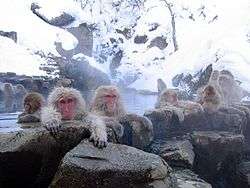
- Shiga Kogen, ski resort[6] with the nearby Jigokudani Monkey Park,[7] famous for the wild Japanese macaque often found bathing in its hot springs.
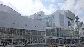
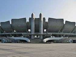
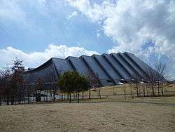
- Sporting venues built for the Winter Olympics including the M-Wave speedskating arena (with the world's largest wooden suspension roof), Big Hat arena, and the Aqua Wing Arena.
Sports
- AC Nagano Parceiro represents Nagano in J3 League
- AC Nagano Parceiro Ladies is a women's football team in the Challenge League based in Nagano
Notable people from Nagano
- Joe Hisaishi, composer
- Kazuo Aoki, politician
- Haruyo Ichikawa, actress
- Toshimi Kitazawa, politician
- Kenji Kosaka, politician
- Isao Kuraishi, actor
- Tadamichi Kuribayashi, general, Imperial Japanese Army
- Emi Nitta, voice actress
- Shusei Tanaka, politician
- Adachi Yuto, member of K-pop boy band Pentagon
References
- ↑ 市政情報 > 市の沿革・概要 > 人口・面積・自然 (in Japanese).
- ↑ 長野市・信州新町・中条村合併後調査報告について. Nagano official website (in Japanese). Nagano City. Retrieved 18 September 2011.
- ↑ "平年値(年・月ごとの値)". Japan Meteorological Agency. Retrieved 2010-10-29.
- ↑ "観測史上1~10位の値(年間を通じての値)". Japan Meteorological Agency. Retrieved 2010-10-29.
- ↑ Government, Nagano Prefectural. "Introduction to Nagano Prefecture / Nagano Prefectural Government". www.pref.nagano.lg.jp. Retrieved 2018-05-25.
- ↑ Snow Monkeys. "Shiga Kogen | Snow Monkeys". Yudanaka-shibuonsen.com. Retrieved 2013-10-04.
- ↑ Snow Monkeys (2012-09-27). "Snow Monkey park | Snow Monkeys". Yudanaka-shibuonsen.com. Retrieved 2013-10-04.
External links
| Wikimedia Commons has media related to Nagano. |
| Wikivoyage has a travel guide for Nagano. |
- Official Website (in Japanese)
| Core city | |
|---|---|
| Special city | |
| Cities | |
| Districts | |
|
| Authority control |
|---|