Christchurch
| Christchurch Ōtautahi (Māori) | |||
|---|---|---|---|
| Metropolitan area | |||
| Christchurch | |||
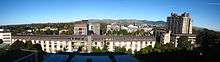
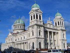
    .jpg)  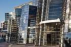 Clockwise from top: Christchurch skyline with Southern Alps in background, New Brighton and the Port Hills, a Christchurch tram, the Christchurch Art Gallery, St James Park in autumn, the Peacock Fountain in the Christchurch Botanic Gardens, and ChristChurch Cathedral in Cathedral Square | |||
| |||
| Nickname(s): The Garden City | |||
|
Motto(s): Fide Condita Fructu Beata Spe Fortis Latin Founded in Faith, Rich in the Fulfillment thereof, Strong in Hope for the Future | |||
 Christchurch | |||
| Coordinates: 43°31′48″S 172°37′13″E / 43.53000°S 172.62028°ECoordinates: 43°31′48″S 172°37′13″E / 43.53000°S 172.62028°E | |||
| Country |
| ||
| Island | South Island | ||
| Region | Canterbury | ||
| Territorial authority | Christchurch City Council | ||
| Wards |
Banks Peninsula Burwood Cashmere Central Coastal Fendalton Halswell Harewood Heathcote Hornby Innes Linwood Papanui Riccarton Spreydon Waimairi | ||
| Settled by the UK | 1848 | ||
| Named for | Christ Church, Oxford | ||
| Government | |||
| • Mayor | Lianne Dalziel | ||
| Area | |||
| • Territorial | 1,426 km2 (551 sq mi) | ||
| • Urban | 607.73 km2 (234.65 sq mi) | ||
| Elevation[1] | 20 m (70 ft) | ||
| Population (June 2017)[2] | |||
| • Territorial | 381,500 | ||
| • Density | 270/km2 (690/sq mi) | ||
| • Urban | 396,700 | ||
| • Urban density | 650/km2 (1,700/sq mi) | ||
| • Demonym | Cantabrian | ||
| Time zone | UTC+12 (NZST) | ||
| • Summer (DST) | UTC+13 (NZDT) | ||
| Postcode(s) | 8011, 8013, 8014, 8022, 8023, 8024, 8025, 8041, 8042, 8051, 8052, 8053, 8061, 8062, 8081, 8082, 8083 | ||
| Area code(s) | 03 | ||
| Local iwi | Ngāi Tahu, Kāti Māmoe | ||
| Website |
www.ccc.govt.nz www.ecan.govt.nz | ||


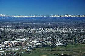
Christchurch (/ˈkraɪstʃɜːrtʃ/; Māori: Ōtautahi) is the largest city in the South Island of New Zealand and the seat of the Canterbury Region. The Christchurch urban area lies on the South Island's east coast, just north of Banks Peninsula. It is home to 396,700 residents,[2] making it New Zealand's third-most populous city behind Auckland and Wellington.
The Avon River flows through the centre of the city, with an urban park located along its banks. At the request of the Deans brothers—whose farm was the earliest settlement in the area—the river was named after the River Avon in Scotland, which rises in the Ayrshire hills near to where their grandfather's farm was located.[3]
Archaeological evidence has indicated that the Christchurch area was first settled by humans in about 1250. Christchurch became a city by Royal Charter on 31 July 1856, making it officially the oldest established city in New Zealand. The Canterbury Association, which settled the Canterbury Plains, named the city after Christ Church, Oxford. The new settlement was laid out in a grid pattern centred on Cathedral Square; during the 19th century there were few barriers to the rapid growth of the urban area, except for the Pacific to the east and the Port Hills to the south.
Agriculture is the historic mainstay of Christchurch's economy. The early presence of the University of Canterbury and the heritage of the city's academic institutions in association with local businesses has fostered a number of technology-based industries.
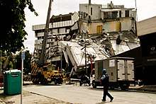
The city suffered a series of earthquakes between September 2010 and early 2012, with the most destructive of them occurring at 12.51 p.m. on Tuesday, 22 February 2011, in which 185 people were killed and thousands of buildings across the city collapsed or suffered severe damage. By late 2013, 1,500 buildings in the city had been demolished, leading to an ongoing recovery and rebuilding project.
Names
The name of "Christchurch" was agreed on at the first meeting of the Canterbury Association on 27 March 1848. It was suggested by founder John Robert Godley, whose alma mater was Christ Church, Oxford.[4]
The Māori name Ōtautahi ("the place of Tautahi") was adopted in the 1930; originally it was the name of a specific site by the Avon River (near present-day Kilmore Street).[5] The site was a seasonal dwelling of Ngāi Tahu chief Te Potiki Tautahi, whose main home was Port Levy on Banks Peninsula. Prior to that the Ngāi Tahu generally referred to the Christchurch area as Karaitiana,[6] a transliteration of the English word Christian.
History
Early history
Archaeological evidence found in a cave at Redcliffs in 1876 has indicated that the Christchurch area was first settled by moa-hunting tribes about 1250 CE. These first inhabitants were thought to have been followed by the Waitaha tribe, who are said to have migrated from the East coast of the North Island in the 16th century. Following tribal warfare, the Waitaha (made of three peoples) were dispossessed by the Ngāti Māmoe tribe. They were in turn subjugated by the Ngāi Tahu tribe, who remained in control until the arrival of European settlers. Following the purchase of land at Putaringamotu (modern Riccarton) by the Weller brothers, whalers of Otago and Sydney, a party of European settlers led by Herriott and McGillivray established themselves in what is now Christchurch, early in 1840. Their abandoned holdings were taken over by the Deans brothers[7] in 1843 who stayed. The First Four Ships were chartered by the Canterbury Association and brought the first 792 of the Canterbury Pilgrims to Lyttelton Harbour. These sailing vessels were the Randolph, Charlotte Jane, Sir George Seymour, and Cressy. The Charlotte Jane was the first to arrive on 16 December 1850. The Canterbury Pilgrims had aspirations of building a city around a cathedral and college, on the model of Christ Church in Oxford.[8]
The name "Christ Church" was decided prior to the ships' arrival, at the Association's first meeting, on 27 March 1848. The exact basis for the name is not known. It has been suggested that it is named for Christchurch, in Dorset, England; for Canterbury Cathedral; or in honour of Christ Church, Oxford. The last explanation is the one generally accepted.[9]
Captain Joseph Thomas, the Canterbury Association's Chief Surveyor, surveyed the surrounding area. By December 1849 he had commissioned the construction of a road from Port Cooper, later Lyttelton, to Christchurch via Sumner.[10] However this proved more difficult than expected and road construction was stopped while a steep foot and pack horse track was constructed over the hill between the port and the Heathcote valley, where access to the site of the proposed settlement could be gained. This track became known as the Bridle Path, because the path was so steep that pack horses needed to be led by the bridle.[11] Goods that were too heavy or bulky to be transported by pack horse over the Bridle Path were shipped by small sailing vessels some eight miles (13 km) by water around the coast and up the estuary to Ferrymead. New Zealand's first public railway line, the Ferrymead Railway, opened from Ferrymead to Christchurch in 1863. Due to the difficulties in travelling over the Port Hills and the dangers associated with shipping navigating the Sumner bar, a railway tunnel was bored through the Port Hills to Lyttelton, opening in 1867.[12]
Christchurch became a city by royal charter on 31 July 1856, the first in New Zealand. Many of the city's Gothic Revival buildings by architect Benjamin Mountfort date from this period. Christchurch was the seat of provincial administration for the Province of Canterbury, which was abolished in 1876. In 1947, New Zealand's worst fire disaster occurred at Ballantyne's Department Store in the inner city, with 41 people killed in a blaze which razed the rambling collection of buildings.[13] The Lyttelton road tunnel between Lyttelton and Christchurch was opened in 1964.[14] Christchurch hosted the 1974 British Commonwealth Games.
Antarctic exploration
Christchurch has a history of involvement in Antarctic exploration – both Robert Falcon Scott and Ernest Shackleton used the port of Lyttelton as a departure point for expeditions, and in the central city there is a statue of Scott sculpted by his widow, Kathleen Scott. Within the city, the Canterbury Museum preserves and exhibits many historic artefacts and stories of Antarctic exploration.
Modern history
2010–12 earthquakes
On Saturday 4 September 2010, a magnitude 7.1 earthquake struck Christchurch and the central Canterbury region at 4:35 am. Located near Darfield, west of the city at a depth of 10 kilometres (6.2 mi), it caused widespread damage to the city and minor injuries, but no direct fatalities.[16][17][18]
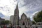
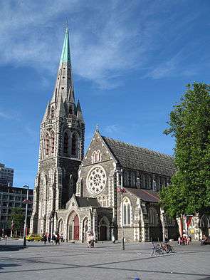
Nearly six months later on Tuesday 22 February 2011, a second earthquake measuring magnitude 6.3 struck the city at 12:51 pm. It was located closer to the city, near Lyttelton at a depth of 5 km (3 mi).[19] Although lower on the moment magnitude scale than the previous earthquake, the intensity and violence of the ground shaking was measured to be IX (Violent), among the strongest ever recorded globally in an urban area[20] and in total 185 people were killed.[21][22] People from more than 20 countries were among the victims.[23] The city's iconic ChristChurch Cathedral was severely damaged and lost its spire.[24][25] The collapse of the CTV Building resulted in the majority of fatalities. Widespread damage across Christchurch resulted in loss of homes, major buildings and infrastructure. Significant liquefaction affected the eastern suburbs, and the total cost to insurers of rebuilding has been estimated at NZ$20–30 billion.[26][27]
On 13 June 2011 Christchurch was hit by two more large aftershocks. A magnitude 5.6 quake at a depth of 9 km (6 mi) hit at 1:00 pm in the general location of Sumner, Christchurch. This was followed by another quake at magnitude 6.3 with a depth of 6 km (4 mi) at 2:20 pm again in the general location of Sumner, Christchurch. There were no fatalities though it resulted in further liquefaction and building damage.[28]
There were further earthquakes on 23 December 2011; the first, of magnitude 5.8 according to the US Geological Survey, 26 km (16 mi) north-east of the city at a depth of 4.7 km (2.9 mi), at 13:58, followed by several aftershocks and another earthquake of magnitude 6.0 and similar location 80 minutes later, with more aftershocks expected.[29][30] St John Ambulance reported after the two quakes that there were minor injuries at homes and businesses but no serious injuries and few indications of building collapses at the time.[31] Christchurch Airport was briefly closed. There were power and water outages at New Brighton and severe damage to the Parklands region, including roads and footpaths.
Christchurch was again rattled awake on 2 January 2012; the first; a magnitude 5.1 struck at 01:27 followed five minutes later by a magnitude 4.2 aftershock; a second larger earthquake struck at 05:45 with a magnitude of 5.5. This caused power outages to the eastern suburbs of Parklands, New Brighton, Shirley, Dallington, Burwood, Spencerville and Richmond; this affected around 10,000 homes.[32]
4,558 earthquakes were recorded in the Canterbury region above a magnitude 3.0, from 4 September 2010 to 3 September 2014.[33]
Following the earthquakes over 1500 buildings in the city had been demolished or partly demolished by September 2013.[34]
The city has been experiencing rapid growth following the earthquakes, with the central city rebuild, which is outlined in the Christchurch Central Recovery Plan, starting to ramp up, and massive growth in the residential sector, with around 50,000 new houses expected to be constructed in the Greater Christchurch area by 2028, as outlined in the Land Use Recovery Plan (LURP).
2013 to present
On 13 February 2017, two bush fires started on the Port Hills. These merged over the next two days and the single very large wild fire extended down both sides of the Port Hill almost reaching Governors Bay in the south-west, and the Westmorland, Kennedys Bush, and Dyers Pass Road almost down to the Sign of the Takahe. Eleven houses were destroyed by fire, over one thousand residents were evacuated from their homes, and over 2,076 hectares (5,130 acres) of land has been burned.[35]
Geography
Christchurch lies in Canterbury, near the centre of the east coast of the South Island, east of the Canterbury Plains. It is located near the southern end of Pegasus Bay, and is bounded to the east by the Pacific Ocean coast and the estuary of the Avon and Heathcote Rivers. To the south and south-east the urban portion of the city is limited by the volcanic slopes of the Port Hills separating it from Banks Peninsula. To the north the city is bounded by the braided Waimakariri River.
Christchurch is one of only eight pairs of cities in the world that have near-exact antipodal cities. Half of these antipodal pairs are in New Zealand and Spain/Morocco–with A Coruña, Spain as Christchurch's antipode.
Christchurch is one of a group of only four cities in the world to have been carefully planned following the same layout of a central city square, four complementing city squares surrounding it and a parklands area that embrace the city centre. The first city built with this pattern was Philadelphia. Later came Savannah and Adelaide, before Christchurch.
Christchurch has one of the highest-quality water supplies in the world, with its water rated among the purest and cleanest in the world.[36] Untreated, naturally filtered water is sourced, via more than 50 pumping stations surrounding the city, from aquifers emanating from the foothills of the Southern Alps.[37]
Central City

At the city's centre is Cathedral Square, surrounding the now-earthquake-damaged – landmark Anglican cathedral, Christ Church. The area around this square and within the Four Avenues of Christchurch (Bealey Avenue, Fitzgerald Avenue, Moorhouse Avenue and Deans Avenue[38]) is considered to be the central business district (CBD) of the city. The central city also has a number of residential areas, including Inner City East, Inner City West, Avon Loop, Moa Neighbourhood and Victoria, but many of the residential buildings in the CBD were demolished following the February 2011 earthquakes. Cathedral Square is located at the crossing of two major central streets, Colombo Street and Worcester Street.
Cathedral Square, the heart of the city, hosted attractions such as (until the February 2011 earthquake)[39] the Wizard of New Zealand, Ian Brackenbury Channell, and evangelist Ray Comfort; regular market days; free standing food and coffee carts; an aquarium, pubs and restaurants and the city's chief tourist information centre. it is expected that activities in Cathedral Square will increase as the rebuild progresses. The Wizard of New Zealand now operates from New Regent Street.[40]
The central city also includes the pedestrianised sections of Cashel and High streets commonly known pre-earthquakes as 'City Mall'. Refurbished in 2008/09 the mall featured especially designed seating, flower and garden boxes, more trees, paving, and an extension to the central city tram route. The tram route extension was nearly complete when the February 2011 earthquake struck. Following the earthquakes, most buildings in Cashel Mall were demolished. A shopping area called Re:START opened on Cashel Street adjacent to Ballantyne's Department Store in October 2011. The Re:START mall is made of colourful shipping containers that have been converted to house retail stores. The Bridge of Remembrance commemorating war dead stands at the western end of the mall, was repaired rededicated on Anzac Day, Monday 25 April 2016.[41][42]
The Cultural Precinct[43] provided a backdrop to a vibrant scene of ever-changing arts, cultural, and heritage attractions within an area of less than one square kilometre. The Arts Centre, the Canterbury Museum and the Art Gallery are located in the Cultural Precinct. The majority of the activities were free and a printable map was provided. There areas are slowly being reopened follow earthquake repair and strengthening work.
In 2010, the Christchurch City Council released "A City For People Action Plan", a programme of work through to 2022 to improve public spaces within the central city to entice more inner city residents and visitors. A primary action was to reduce the impact of motorised private vehicles and increase the comfort of pedestrians and cyclists. The plan was based on a report prepared for the council by renowned Danish design firm Gehl Architects. Since the February 2011 Christchurch earthquake Wellington architect Ian Athfield has been selected to re-plan, although many varied suggestions have been promoted for rebuilding the central city.[44][45][46][47]
The Central City, which was fully closed off following 22 February earthquake, opened in stages and was fully reopened in June 2013. There are still some streets closed off due to earthquake damage, infrastructure repair work, and damaged buildings.[48]
Inner suburbs
(clockwise, starting north of the city centre)
Outer suburbs
(clockwise, starting north of the city centre)
- Marshland
- Bottle Lake
- Burwood
- Parklands
- Prestons
- Highfield
- Waimairi Beach
- Avondale
- North New Brighton
- New Brighton
- Bexley (now largely defunct)
- Aranui
- Wainoni
- South Brighton
- Southshore
- Bromley
- Mt Pleasant
- Redcliffs
- Moncks Bay
- Clifton
- Richmond Hill
- Sumner
- Scarborough Hill
- Ferrymead
- Heathcote Valley
- Hillsborough
- Murray Aynsley
- Huntsbury
- Cashmere
- Westmorland
- Hoon Hay
- Hillmorton
- Aidanfield
- Halswell
- Kennedys Bush
- Oaklands
- Westlake
- Longhurst
- Knight Stream Park
- Wigram
- Middleton
- Sockburn
- Hornby
- Hei Hei
- Broomfield
- Islington
- Yaldhurst
- Russley
- Avonhead
- Harewood
- Bishopdale
- Northcote
- Casebrook
- Redwood
- Regents Park
- Styx Mill
- Northwood
- Groynes Park
- Belfast
- Spencerville
- Brooklands
Satellite towns
- Leeston
- Lyttelton
- Governors Bay
- Diamond Harbour
- Tai Tapu
- Little River
- Lincoln
- Prebbleton
- Rolleston
- Templeton
- West Melton
- Rangiora
- Woodend
- Waikuku
- Pegasus Town
- Kaiapoi
- Kainga
- Pines Beach
- Akaroa
- Motukarara
Climate
| Christchurch | ||||||||||||||||||||||||||||||||||||||||||||||||||||||||||||
|---|---|---|---|---|---|---|---|---|---|---|---|---|---|---|---|---|---|---|---|---|---|---|---|---|---|---|---|---|---|---|---|---|---|---|---|---|---|---|---|---|---|---|---|---|---|---|---|---|---|---|---|---|---|---|---|---|---|---|---|---|
| Climate chart (explanation) | ||||||||||||||||||||||||||||||||||||||||||||||||||||||||||||
| ||||||||||||||||||||||||||||||||||||||||||||||||||||||||||||
| ||||||||||||||||||||||||||||||||||||||||||||||||||||||||||||
Christchurch has a temperate oceanic climate with a mild summer, cool winter, and regular moderate rainfall. It has mean daily maximum air temperatures of 22.5 °C (73 °F) in January and 11.3 °C (52 °F) in July.[49] Under the Köppen climate classification, Christchurch has an oceanic climate (Cfb). Summer in the city is mostly warm but is often moderated by a sea breeze from the Northeast. A record temperature of 41.6 °C (107 °F) was reached in February 1973. A notable feature of the weather is the nor'wester, a hot föhn wind that occasionally reaches storm force, causing widespread minor damage to property.[50] Like many cities, Christchurch experiences an urban heat island effect; temperatures are slightly higher within the inner city regions compared to the surrounding countryside.[51]
In winter it is common for the temperature to fall below 0 °C (32 °F) at night. There are on average 80 days of ground frost per year.[52] Snowfalls occur on average three times per year, although in some years no snowfall is recorded.[53] The coldest temperature recorded was −7.1 °C (19 °F) on 18 July 1945, the third lowest recorded temperature of New Zealand's major cities.[53][54]
On cold winter nights, the surrounding hills, clear skies, and frosty calm conditions often combine to form a stable inversion layer above the city that traps vehicle exhausts and smoke from domestic fires to cause smog. While not as bad as smog in Los Angeles or Mexico City, Christchurch smog has often exceeded World Health Organisation recommendations for air pollution.[55] To limit air pollution, the regional council banned the use of open fires in the city in 2006.[56] In 2008 council prohibited the use of woodburners more than 15 years old, while making funding available to upgrade domestic home heating systems.[57]
| Climate data for Christchurch International Airport (1943–2015, Sunshine 1949–2015, Temperature 1953–2015, Humidity 1960–2015) | |||||||||||||
|---|---|---|---|---|---|---|---|---|---|---|---|---|---|
| Month | Jan | Feb | Mar | Apr | May | Jun | Jul | Aug | Sep | Oct | Nov | Dec | Year |
| Record high °C (°F) | 35.9 (96.6) |
41.6 (106.9) |
35.9 (96.6) |
29.9 (85.8) |
27.3 (81.1) |
22.5 (72.5) |
22.4 (72.3) |
22.8 (73) |
26.2 (79.2) |
30.1 (86.2) |
32.0 (89.6) |
36.0 (96.8) |
41.6 (106.9) |
| Average high °C (°F) | 22.4 (72.3) |
21.9 (71.4) |
20.0 (68) |
17.3 (63.1) |
14.2 (57.6) |
11.4 (52.5) |
10.7 (51.3) |
12.2 (54) |
14.6 (58.3) |
16.9 (62.4) |
19.0 (66.2) |
20.9 (69.6) |
16.8 (62.2) |
| Daily mean °C (°F) | 17.1 (62.8) |
16.8 (62.2) |
15.0 (59) |
12.1 (53.8) |
9.0 (48.2) |
6.2 (43.2) |
5.7 (42.3) |
7.1 (44.8) |
9.3 (48.7) |
11.5 (52.7) |
13.6 (56.5) |
15.7 (60.3) |
11.6 (52.9) |
| Average low °C (°F) | 11.8 (53.2) |
11.6 (52.9) |
9.9 (49.8) |
6.8 (44.2) |
3.8 (38.8) |
1.1 (34) |
0.7 (33.3) |
2.0 (35.6) |
4.0 (39.2) |
6.1 (43) |
8.1 (46.6) |
10.6 (51.1) |
6.4 (43.5) |
| Record low °C (°F) | 3.0 (37.4) |
1.5 (34.7) |
−0.2 (31.6) |
−4.0 (24.8) |
−6.4 (20.5) |
−7.2 (19) |
−6.8 (19.8) |
−6.7 (19.9) |
−4.4 (24.1) |
−4.2 (24.4) |
−2.6 (27.3) |
0.1 (32.2) |
−7.2 (19) |
| Average rainfall mm (inches) | 43.5 (1.713) |
43.5 (1.713) |
52.8 (2.079) |
52.9 (2.083) |
63.0 (2.48) |
58.5 (2.303) |
62.5 (2.461) |
57.6 (2.268) |
42.4 (1.669) |
48.3 (1.902) |
47.5 (1.87) |
50.4 (1.984) |
622.9 (24.524) |
| Average rainy days (≥ 1.0 mm) | 5.9 | 5.4 | 6.3 | 6.7 | 7.8 | 8.0 | 8.2 | 7.3 | 6.1 | 6.9 | 6.6 | 7.1 | 82.3 |
| Average relative humidity (%) (at 9 am) | 72.5 | 79.0 | 80.9 | 83.9 | 86.3 | 87.2 | 87.8 | 85.8 | 78.7 | 73.9 | 70.5 | 71.3 | 79.8 |
| Mean monthly sunshine hours | 224.4 | 190.5 | 177.4 | 155.6 | 133.3 | 117.7 | 124.8 | 149.0 | 166.6 | 201.3 | 215.3 | 214.3 | 2,070.2 |
| Percent possible sunshine | 48.3 | 49.1 | 46.2 | 47.5 | 44.5 | 43.6 | 43.3 | 46.4 | 47.2 | 49.0 | 49.1 | 45.0 | 46.6 |
| Source #1: CliFlo[58] | |||||||||||||
| Source #2: Time and Date (potential monthly daylight hours)[59] | |||||||||||||
Demographics
The area administered by the Christchurch City Council has a population of 381,500 (June 2017),[2] making it the second-largest in New Zealand, and the largest city in the South Island.
The Christchurch urban area at 396,700 is the third-largest in the country by population, after Auckland and Wellington. The urban area differs from the city by including Kaiapoi in the Waimakariri District and Prebbleton in the Selwyn District, while excluding most of the Banks Peninsula.
| Historical Population of Christchurch City | ||
|---|---|---|
| New Zealand census | Pop. | ±% |
| 1981 | 281,721[60] | – |
| 1986 | 288,948[60] | 2.6% |
| 1991 | 296,061[60] | 2.5% |
| 1996 | 316,611[60] | 6.9% |
| 2001 | 323,956[60] | 2.3% |
| 2006 | 348,435[60] | 7.6% |
| 2013 | 341,469[61] | -2.0% |
Culture and identity
| Largest groups of overseas-born residents[62][63] | |
| Nationality | Population (2013) |
|---|---|
| 17,571 | |
| 6,822 | |
| 5,529 | |
| 3,126 | |
| 2,739 | |
| 2,694 | |
| 2,466 | |
| 2,439 | |
| 2,187 | |
| 1,995 | |
The following table shows the ethnic profile of Christchurch's population, as recorded in the 2001 and 2006 New Zealand census. The percentages add up to more than 100%, as some people counted themselves as belonging to more than one ethnic group. Figures for 2006 refer to just Christchurch City, not the whole urban area. The substantial percentage drop in the numbers of 'Europeans' was mainly caused by the increasing numbers of people from this group choosing to define themselves as 'New Zealanders'–even though this was not one of the groups listed on the census form.
Approximately 62% of the South Island's Pacific Islander community reside in Christchurch and the surrounding Canterbury region, equalling approximately 11,500 people.[64] People of Samoan descent comprise about half the Pacific Islander population.[64] There are also smaller communities of Cook Islanders, Fijians, Niueans, Tokelauans and Tongans residing in the city.[64]
| Ethnicity | 2001 census | 2006 census | 2013 census | |||
|---|---|---|---|---|---|---|
| Number | % | Number | % | Number | % | |
| European | 282,333 | 89.7 | 255,384 | 75.4 | 273,306 | 83.9 |
| New Zealand European | 267,993 | 85.1 | 235,776 | 69.6 | 253,638 | 77.9 |
| British | 1,419 | 0.5 | 2,604 | 0.8 | 3,132 | 1.0 |
| English | 2,763 | 0.9 | 3,558 | 1.1 | 2,904 | 0.9 |
| Dutch | 2,877 | 0.9 | 2,835 | 0.8 | 2,574 | 0.8 |
| European (not further defined) | 1,749 | 0.6 | 1,803 | 0.5 | 2,013 | 0.6 |
| Australian | 1,827 | 0.6 | 2,505 | 0.7 | 1,905 | 0.6 |
| Asian | 17,625 | 5.6 | 26,634 | 7.9 | 30,717 | 9.4 |
| Chinese | 7,869 | 2.5 | 11,712 | 3.5 | 11,802 | 3.6 |
| Indian | 1,749 | 0.6 | 2,817 | 0.8 | 4,752 | 1.5 |
| Filipino | 639 | 0.2 | 1,002 | 0.3 | 3,408 | 1.0 |
| Korean | 2,892 | 0.9 | 4,569 | 1.3 | 3,156 | 1.0 |
| Japanese | 1,866 | 0.6 | 2,208 | 0.7 | 2,118 | 0.7 |
| Māori | 22,533 | 7.2 | 25,728 | 7.6 | 27,765 | 8.5 |
| Pacific peoples | 7,674 | 2.4 | 9,465 | 2.8 | 10,101 | 3.1 |
| Samoan | 5,064 | 1.6 | 6,105 | 1.8 | 6,012 | 1.8 |
| Middle Eastern/Latin American/African | 1,974 | 0.6 | 2,859 | 0.8 | 3,384 | 1.0 |
| Other | 87 | <0.1 | 43,778 | 12.9 | 6,276 | 1.9 |
| New Zealander | N/A | 43,677 | 12.9 | 6,132 | 1.9 | |
| Total people stated | 314,883 | 338,772 | 325,719 | |||
| Not elsewhere included | 9,195 | 2.8 | 9,687 | 2.8 | 15,750 | 4.6 |
The 2006 Census also provides information about the multilinguality of the region. Of those people in Christchurch City who provided data, 86% spoke one language only, 12% spoke two, and 2% could converse in three or more languages.[66]
Economy
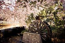
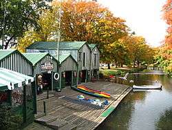
Farming
.jpg)
The agricultural industry has always been the economic core of Christchurch.[67] The city has long had industry based on the surrounding farming country – part of the original "package" New Zealand was sold to immigrants as.[68] PGG Wrightson, New Zealand's leading agribusiness, is based in Christchurch.[69] Its local roots go back to Pyne Gould Guinness, an old stock and station agency serving the South Island.[70] Other agribusinesses in Christchurch have included malting, seed development and dressing, wool and meat processing, and small biotechnology operations using by-products from meat works.[67] Dairying has grown strongly in the surrounding areas with high world prices for milk products and the use of irrigation to lift grass growth on dry land. With its higher labour use this has helped stop declines in rural population. Many cropping and sheep farms have been converted to dairying. Conversions have been by agribusiness companies as well as by farmers, many of whom have moved south from North Island dairying strongholds such as Taranaki and the Waikato.
Cropping has always been important in the surrounding countryside. Wheat and barley and various strains of clover and other grasses for seed exporting have been the main crops. These have all created processing businesses in Christchurch. In recent years, regional agriculture has diversified, with a thriving wine industry springing up at Waipara, and beginnings of new horticulture industries such as olive production and processing. Deer farming has led to new processing using antlers for Asian medicine and aphrodisiacs. The high quality local wine in particular has increased the appeal of Canterbury and Christchurch to tourists.[71]
Industry
Christchurch is the second largest manufacturing centre in New Zealand behind Auckland, the sector being the second largest contributor to the local economy,[72] with firms such as Anderson's making steel work for bridges, tunnels, and hydro-electric dams in the early days of infrastructure work. Now manufacturing is mainly of light products and the key market is Australia, with firms such as those pioneered by the Stewart family among the larger employers. Before clothing manufacture largely moved to Asia, Christchurch was the centre of the New Zealand clothing industry, with firms such as LWR Industries. The firms that remain mostly design and market, and manufacture in Asia. The city also had five footwear manufacturers, but these have been replaced by imports.
In the last few decades, technology-based industries have sprung up in Christchurch.[73] Angus Tait founded Tait Electronics, a mobile-radio manufacturer, and other firms spun off from this, such as Dennis Chapman's Swichtec. In software, Cantabrian Gil Simpson founded a company that made LINC and Jade programming languages and a management buyout spawned local firm Wynyard Group.
There have also been spin-offs from the electrical department of the University of Canterbury engineering school. These included Pulse Data, which became Human Ware (making reading devices and computers for blind people and those with limited vision) and CES Communications (encryption). The Pulse Data founders had moved from the Canterbury University engineering school to work for Wormald Inc. when they set up Pulse Data through a Management buyout of their division.
In recent times, the University of Canterbury engineering school and computer science department play an important role in supplying staff and research for the technology industries, and the Christchurch Polytechnic Institute of Technology provides a flow of trained technicians and engineers. Locally and nationally, the IT sector is known not for its size (the third largest in New Zealand) but for producing innovative and entrepreneurial solutions, products and concepts.[74]
Tourism
Tourism is also a significant factor of the local economy. The close proximity of the ski fields and other attractions of the Southern Alps, and hotels, a casino, and an airport that meet international standards make Christchurch a stopover destination for many tourists. The city is popular with Japanese tourists,[75] with signage around Cathedral Square in Japanese.
Gateway to the Antarctic
The International Antarctic Centre provides both base facilities and a museum and visitor centre focused upon current Antarctic activities. The United States Navy and United States Air National Guard, augmented by the New Zealand and Australian air forces, use Christchurch Airport as the take-off point for the main supply route to McMurdo and Scott Bases in Antarctica. The Clothing Distribution Center in Christchurch had more than 140,000 pieces of extreme cold weather gear for issue to nearly 2,000 US Antarctic Program participants in the 2007–08 season.[76]
Government
Local government
Christchurch's local government is a democracy with various elements including:
- Christchurch City Council, comprising the Mayor of Christchurch, and 16 councillors elected in 16 wards: Spreydon, Cashmere, Halswell, Riccarton, Hornby, Fendalton, Waimairi, Papanui, Innes, Central, Linwood, Heathcote, Harewood, Burwood, Coastal, and Banks Peninsula.
- Community boards (six in the pre-amalgamation city area), each covering 2-3 wards with 2 members elected and one Councillor appointed from each: Spreydon-Cashmere, Papanui-Innes, Linwood-Central-Heathcote, Fendalton-Waimairi-Heathcote, Coastal-Burwood; and one covering Banks Peninsula but with members elected from 4 subdivisions.
- District councils in surrounding areas: Selwyn, and Waimakariri. The Banks Peninsula district council was amalgamated into Christchurch City in March 2006 after a vote by the Banks Peninsula residents to disestablish in November 2005.
- Canterbury Regional Council, known as 'Environment Canterbury', including four Christchurch constituencies with two members from each constituency.[77]
- District Health Board (Canterbury), with five members for Christchurch.[78]
Some of the local governments in Canterbury and the NZ Transport Agency have created the Greater Christchurch Urban Development Strategy to facilitate future urban planning.[79]
Central government
Christchurch is covered by seven general electorates (Christchurch Central, Christchurch East, Ilam, Port Hills, Selwyn, Waimakariri and Wigram) and one Māori electorate (Te Tai Tonga),[80] each returning one member to the New Zealand House of Representatives. As of the New Zealand general election, 2017 there are four members of the Labour party and three members of the National party.
Education
Secondary schools
Christchurch is home to the fourth largest school in New Zealand, co-educational state school Burnside High School, with 2504 pupils. Cashmere High School, Papanui High School and Riccarton High School are other large schools. There are four single-sex state schools: Shirley Boys' High School, Christchurch Boys' High School, Avonside Girls' High School and Christchurch Girls' High School.
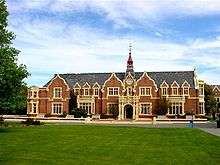
Christchurch is also well known for several independent schools and church schools, some of them of the traditional English public school type. These include St Thomas of Canterbury College, St Margaret's College, Christ's College, St Bede's College, Marian College, Catholic Cathedral College, St Andrew's College, Villa Maria College and Rangi Ruru Girls' School. Less conventional schools in the city include Unlimited Paenga Tawhiti and Hagley Community College.
Tertiary institutions
A number of tertiary education institutions have campuses in Christchurch, or in the surrounding areas.
Transport
Christchurch is served by Christchurch International Airport and by buses (local and long-distance) and trains. The local bus service, known as Metro,[81] is provided by Environment Canterbury. The car, however, remains the dominant form of transport in the city, as with the rest of New Zealand.
Christchurch has over 2,300 km of roads, of this 360 km is unpaved and 26 km is motorway.[82] Christchurch has three motorways consisting of the Christchurch Northern Motorway (includes the Western Belfast Bypass), Christchurch Southern Motorway and the Christchurch-Lyttelton Motorway.[83][84]
Christchurch has an extensive bus network with bus routes serving most areas of the city and satellite towns. Nearly all bus routes travelled through the central city Bus Exchange before the earthquake but due to reduced passenger numbers since the earthquakes, especially in the central city, the bus network was reorganised to direct more localised services to 'hubs', such as major shopping centres, where they connect to the central station via core bus routes. Before the 2011 earthquakes, in addition to normal bus services, Christchurch also had a pioneering zero-fare hybrid bus service, the Shuttle, in the inner city. The service has been suspended following the earthquakes and it is unclear whether it will resume again in the future.[85] Bus services are also available leaving Christchurch, daily passenger bus services[86] operates between Dunedin and Christchurch on the State Highway 1.
Historically, Christchurch has been known as New Zealand's cycling city[87] and currently still attracts about 7% of commuters cycling. The central city has very flat terrain and the Christchurch City Council has established a network of cycle lanes and paths, such as the Railway Cycleway. Post-quake public consultation on rebuilding the city expressed a strong desire for a more sustainable transport system, particularly greater use of cycling again, and this has been reflected in the Council's strategic transport plan.[88]
The Christchurch City Council has committed NZ$68.5 million to build a network of modern cycleways over the next five years.
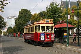
There is a functioning Christchurch tramway system in Christchurch, but as a tourist attraction; its loop is restricted to a circuit of the central city. The trams were originally introduced in 1905 as a form of public transport, and ceased operating in 1954,[89] but returned to the inner city (as a tourist attraction) in 1995. However, following the February 2011 earthquake, the system was damaged and within the cordoned off 'Red Zone' of the central city. The tramway reopened in November 2013 on a limited route, with plans to extend the tram route in 2014, first to reopen the complete pre-earthquake circuit, and then to open the extension travelling through the Re:Start Mall and High Street, which was being constructed when the 2011 earthquake struck.
There is a cable car system called the Christchurch Gondola which operates as a tourist attraction, providing transport from the Heathcote Valley to the top of Mount Cavendish in the city's south-east.
Rail services, both long-distance and commuter, used to focus on the former railway station on Moorhouse avenue. Commuter trains were progressively cancelled in the 1960s and 1970s. The last such service, between Christchurch and Rangiora, ceased in 1976. After the reduction in services a new Christchurch railway station was established at Addington Junction. The Main North Line railway travels northwards via Kaikoura to Picton and is served by the TranzCoastal passenger train, while the Main South Line heads to Invercargill via Dunedin and was used by the Southerner until its cancellation in 2002. The most famous train to depart Christchurch is the TranzAlpine, which travels along the Main South Line to Rolleston and then turns onto the Midland Line, passes through the Southern Alps via the Otira Tunnel, and terminates in Greymouth on the West Coast. This trip is often regarded as one of the ten great train journeys in the world for the amazing scenery through which it passes. The TranzAlpine service is primarily a tourist service and carries no significant commuter traffic.
The Christchurch International Airport serves as the major base for the New Zealand, Italian and United States Antarctic programs.
Culture and entertainment
Christchurch is a distinctly English city, however it contains various European elements, with strong Gothic Revival architecture. As early settlers of New Zealand, Māori culture is also prevalent in the city. It features many public open spaces and parks, river beds and cafés and restaurants situated in the city centre and surrounding suburbs.
Cinema
While historically most cinemas were grouped around Cathedral Square,[90] only two cinemas remain there. The Regent complex was rebuilt as 'Regent on Worcester' in 1996. In 2009 Metro Cinemas opened in Worcester Street with three screens.
Only one of the first generation of suburban cinemas, the Hollywood in Sumner, remains open.[91] The largest multiplexes were the Hoyts 8 in the old railway station on Moorhouse Avenue (now demolished) and Reading Cinemas (also eight screens) in the Palms shopping centre in Shirley. Hoyts in Riccarton opened in 2005[92] with one of its screens for a time holding the record for the largest in New Zealand.
The Rialto Cinemas on Moorhouse avenue specialised in international films and art house productions. The Rialto also hosted the majority of the city's various film festivals and was home to the local film society. The Rialto was closed following the February 2011 earthquake.
The Christchurch Arts Centre includes two art house cinemas, Cloisters and The Academy, screening a wide selection of contemporary, classic and foreign language films.
The Canterbury Film Society is active in the city.[93]
The matricidal Peter Jackson film Heavenly Creatures (1994), starring Melanie Lynskey and Kate Winslet, was set in Christchurch.[94]
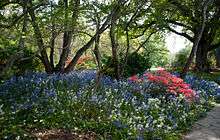
Parks and nature
The large number of public parks and well-developed residential gardens with many trees has given Christchurch the name of The Garden City.[95] Hagley Park and the 30-hectare (75 acre) Christchurch Botanic Gardens, founded in 1863, are in the central city, with Hagley Park being a site for sports such as golf, cricket, netball, and rugby, and for open-air concerts by local bands and orchestras. To the north of the city is the Willowbank wildlife park. Travis Wetland, an ecological restoration programme to create a wetland, is to the east of the city centre in the suburb of Burwood.
Television
Christchurch had its own regional television station Canterbury Television. CTV was first formed in 1991 and ceased broadcasting on 16 December 2016. It aired both local, national and international content, including DW-TV and Al-jazeera World. Since 19 December 2016 CTV has operated as a web-based platform under the Star Media brand.
VTV, a Korean TV channel airs in Christchurch (also Auckland). It offers English content about Korea, from arirang World, and Korean-speaking content in SBS. This channel broadcasts many of the latest dramas airing in Korea.
The city's main television transmitter is located atop Sugarloaf, in the Port Hills due south of the city centre, and broadcasts all major national television channels as well as the two local channels. All television channels in Christchurch have been broadcast in digital since analogue switch-off on 28 April 2013.
Theatre
Christchurch has one full-time professional theatre, the Court Theatre,[96] founded in 1971. Originally based in the Christchurch Arts Centre, the Court Theatre has been located in the suburb of Addington in temporary accommodation following the 2011 earthquakes. Alongside the Court, the co-operative and experimental Free Theatre Christchurch was established in 1979 and based in the Arts Centre from 1982.[97] There is also an active recreational theatre scene with community based theatre companies, such as the Christchurch Repertory Society,[98] Elmwood Players,[99] Riccarton Players,[100] and Canterbury Children's Theatre,[101] producing many quality shows. The Ngaio Marsh Theatre, located at the University of Canterbury, hosts a range of student drama groups, as well as other theatre groups. The Isaac Theatre Royal was originally opened in 1863, and has since been rebuilt four times, most recently following the 2011 Christchurch earthquake.[102] The Isaac Theatre Royal reopened to the public on 17 November 2014.
Music
The city is known for its many live acts,[103][104][105][106] has a professional symphony orchestra,[107] and is the base of professional opera company, Southern Opera.[108] Christchurch is a home for the experimental music scene of New Zealand. The town is the home to such bands as The Bats, The Narcs, Shocking Pinks and Bailter Space.
There are usually buskers around the town square and Christchurch also hosts the World Buskers Festival in January each year. Singer/songwriter Hayley Westenra launched her international career by busking in Christchurch. Soon she was signed to Universal Music Group New Zealand, then later to Decca Label Group in London, England, where she now bases her career.
Christchurch also has a Metal scene, with metal acts playing in various locations around the central city.
Some of New Zealand's acts such as Shapeshifter, Ladi6, Tiki Taane and Truth are from Christchurch. Promoters, Venues and clubs such as Bassfreaks, The Bedford and Dux Live regularly have international and New Zealand acts within the Drum and Bass scene performing live in Christchurch, along with dance parties, raves and gigs all featuring NZ and local Drum and Bass DJs, with often two or three happening on a single night or weekend (e.g. 2010 when UK Dubstep DJ Doctor P with Crushington was playing at The Bedford, while simultaneously Concord Dawn featuring Trei and Bulletproof was playing at Ministry). Independent Christchurch based radio station Pulzar FM is one of the few radio stations in New Zealand that plays Drum and Bass during the day.
In recent developments, hip hop has effectively landed in Christchurch. In 2000, First Aotearoa Hip Hop Summit was held there. And in 2003, Christchurch's own Scribe released his debut album in New Zealand and has received five times platinum in that country, in addition to achieving two number one singles.[109][110]
Venues
.jpg)
The Horncastle Arena is New Zealand's second largest permanent multipurpose arena, seating between 5000 and 8000, depending on configuration. It is home of the Canterbury Tactix netball side. It was the venue for the 1999 World Netball championships and has been host to many concerts in recent years.
The Christchurch Town Hall auditorium (2500 seats, opened 1972) was the first major auditorium design by architects Warren and Mahoney and acoustician Marshall Day. It is still recognised as a model example of concert-hall design with an excellent modern pipe organ. The town hall is currently closed for repair after the significant damage caused by the February 2011 Christchurch earthquake.
Christchurch also has a casino,[111] and there are also a wide range of live music venues[103][112]—some short-lived, others with decades of history. Classical music concerts are held at the Christchurch Music Centre.
In late 2014 it was announced that a 284 million dollar project was underway to build a convention centre located on the block defined by Armagh Street, Oxford Terrace, Worcester Street and Colombo Street. Gloucester Street will become part of the Centre itself, but will allow for retail use and public access. The convention centre will be able to host several events at the same time; starting with space for up to 2,000 people, this will complement facilities in Auckland and Queenstown. The scheduled opening of the convention centre is uncertain.[113]
Sport
Teams
- Crusaders, formerly the 'Canterbury Crusaders', are a rugby union team based in Christchurch that compete in the Super Rugby competition.
- The Canterbury Rugby Football Union, which governs rugby union in Christchurch and the surrounding region, fields a team that represents the city in the ITM Cup.
- Canterbury Kings are Christchurch's men's cricket team in New Zealand's State Championship while the Canterbury Magicians play in the counterpart women's tournament
- Canterbury Cavaliers and Cats play in the National Hockey League (NHL)
- Canterbury Tactix play in the national ANZ Premiership, after the trans-Tasman ANZ Championship netball league finished in 2016. Prior to 2008, the Canterbury Flames played in the national netball league, competing for the National Bank Cup.
- Canterbury United play in the New Zealand Football Championship.
- Canterbury Rams play in the National Basketball League.
- Canterbury Red Devils play in the New Zealand Ice Hockey League (NZIHL).
- In addition, Christchurch Football Club, an amateur rugby union club, was founded in 1863, believed to be the oldest club of any code in New Zealand.[114]
Events
- 1974 British Commonwealth Games
- 1982 Women's Cricket World Cup
- 1989 XVI World Games for the Deaf (Now known Deaflympics) This was the first time the World Deaf Games was held in the Southern Hemisphere, in Christchurch
- 1992 Cricket World Cup
- 1999 World Netball Championships
- 2000 Women's Cricket World Cup
- 2011 IPC Athletics World Championships
- 2015 Cricket World Cup
Venues

- Addington Raceway at Addington has been a venue for harness racing since 1899. Racing is conducted by the New Zealand Metropolitan Trotting Club and it is regarded as the premier venue for the sport in New Zealand.[115]
- Alpine Ice is an ice skating rink home to the Canterbury Red Devils. It has hosted many national and international Ice Hockey tournaments, figure skating and speed skating events. The rink is home to Ice Sports in Canterbury, in turn hosting numerous Ice Sports Clubs including the Canterbury Ice Hockey Association.
- English Park in St Albans is the home venue for the Canterbury United Football team that plays in the national league.
- Golf courses: Christchurch has more than a dozen golf courses, and has hosted the PGA Tour of Australasia/Nationwide Tour co-sanctioned Clearwater Classic/NZ PGA Championship at Clearwater Resort since 2002.
- Hagley Oval, located within the southern portion of Hagley Park, has been used on-and-off as a venue for local, national and international cricket matches for decades, and was upgraded in 2014 as part of preparation for the 2015 Cricket World Cup.[116] This included the construction of a new pavilion and embankment for seating, since which point the ground has returned to prominence as a dedicated cricket ground for all levels of the game.
- Horncastle Arena in Addington, Christchurch. Hosted the 1999 Netball World Championships and continues to host international basketball and netball games.
- Lancaster Park (formerly Jade Stadium & AMI Stadium) was Christchurch's premier outdoor sporting ground, which played host to rugby union in the winter months and cricket in the summer months. It was home to the Crusaders Super Rugby and Canterbury Air New Zealand Cup rugby teams. It was also used by the New Zealand national cricket team and occasionally hosted a New Zealand Warriors rugby league match. Is had a capacity of around 40,000 people for sporting fixtures, and around 50,000 for concerts. Damaged during the 2011 February earthquake, the facility's future is uncertain.[117]
- Malvern Park in St Albans hosts inter-high school competition matches as well as minor league matches. Also training grounds for the Canterbury Crusaders.
- Nunweek Park in Bishopdale is the main hockey venue in the city. Porritt Park in Avonside was the main venue until the 2010 Canterbury earthquake, when it was damaged by liquefaction.
- Queen Elizabeth II Park was built for the 1974 British Commonwealth Games, which Christchurch hosted. It is used primarily as an athletics park, but also contains a newly upgraded swimming pool complex. It has hosted major concerts from bands such as AC/DC and the Red Hot Chili Peppers. The facility has been demolished due to damage sustained in the 22 February earthquake.[118]
- Riccarton Park is a major thoroughbred racing venue.
Sister cities
Christchurch has seven sister cities around the world. They are:[119]


See also
References
Notes
- ↑ "NZ Topographic Map". Land Information New Zealand. Retrieved 25 September 2017.
- 1 2 3 "Subnational Population Estimates: At 30 June 2017 (provisional)". Statistics New Zealand. 24 October 2017. Retrieved 24 October 2017. For urban areas, "Subnational population estimates (UA, AU), by age and sex, at 30 June 1996, 2001, 2006-16 (2017 boundary)". Statistics New Zealand. 24 October 2017. Retrieved 24 October 2017.
- ↑ A History of Canterbury, Vol. 1 – Sir James Hight & Straubel, C.R.; Canterbury Centennial Association and Whitcombe and Tombs, Christchurch 1957, Page 121
- ↑ Cowie, D. J. (1934). "How Christchurch Got Its Name — A Controverted Subject". Victoria University of Wellington. Retrieved 15 August 2017.
- ↑ "Ōtautahi – Christchurch". Christchurch City Libraries. Retrieved 15 August 2017.
- ↑ Ōtautahi (from the Christchurch City Library website)
- ↑ "Deans cottage web site". Riccartonhouse.co.nz. Retrieved 23 February 2011.
- ↑ Cathedral History (from the official ChristChurch cathedral website). Archived 17 October 2007 at the Wayback Machine.
- ↑ Cowie, D.J. (2 July 1934). "How Christchurch Got Its Name: A Controverted Subject". The New Zealand Railways Magazine. New Zealand Railways. 9 (4): 31. OCLC 52132159. Retrieved 4 March 2011.
- ↑ "Captain Thomas and the Streets of Christchurch". Christchurch City Libraries.
- ↑ Rescue, the Sumner community and its lifeboat service – Amodeo, Colin (editor), Christchurch: Sumner Lifeboat Institution Incorporated, 1998
- ↑ "Chch City Libraries". my.christchurchcitylibraries.com. 26 January 2010. Retrieved 5 March 2015.
- ↑ "Ballantyne's fire". my.christchurchcitylibraries.com. 18 November 1947. Retrieved 5 March 2015.
- ↑ "Te Ara". Te Ara. 2 March 2009. Retrieved 23 February 2011.
- ↑ "Christchurch Earthquake: Workers trapped in crushed buildings". New Zealand Herald. 22 February 2011.
- ↑ Strong quake hits in Darfield, Canterbury near Christchurch, Radio New Zealand, 4 September 2010
- ↑ "New Zealand Quake Victims Say 'It was terrifying'". The Epoch Times. 3 September 2010. Retrieved 4 September 2010.
- ↑ "New Zealand's South Island Rocked by Magnitude 7.0 Earthquake". Bloomberg L.P. 3 September 2010. Retrieved 4 September 2010.
- ↑ "New Zealand Earthquake Report – Feb 22, 2011 at 12:51 pm (NZDT)". GeoNet. Earthquake Commission and GNS Science. 22 February 2011. Archived from the original on 23 February 2011. Retrieved 22 February 2011.
- ↑ Fox, Andrea (1 March 2011). "Building code no match for earthquake". The Dominion Post. Retrieved 11 July 2011.
- ↑ "Official quake toll rises to 185". Stuff.co. 9 February 2012. Retrieved 9 February 2012.
- ↑ "List of deceased – Christchurch earthquake". New Zealand Police. 8 September 2011. Retrieved 26 December 2011.
- ↑ "Earthquake toll rises to 145". New Zealand Herald. 26 February 2011. Retrieved 26 February 2011.
- ↑ "Large quake strikes Christchurch". Dominion Post. 2011. Archived from the original on 24 September 2012. Retrieved 22 February 2011.
- ↑ "Christchurch quake: People likely to be trapped in cathedral". New Zealand Herald. 22 February 2011. Retrieved 22 February 2011.
- ↑ Rotherham, Fiona (10 May 2011). "Quake rebuild will eat into GDP". Stuff.co.nz. Retrieved 15 May 2011.
- ↑ Buhayar, Noah; Greber, Jacob; Saminather, Nichola (23 February 2011). "New Zealand's Earthquake May Become Costliest Insured Disaster Since 2008". Bloomberg L.P. Retrieved 24 February 2011.
- ↑ "'Thousands of homes need to go'". The Press. 14 June 2011. Retrieved 24 September 2011.
- ↑ "New Zealand's Christchurch rocked by earthquakes". BBC. 23 December 2011. Retrieved 4 November 2013.
- ↑ "Christchurch: More quakes expected". nzherald.co.nz. 23 December 2011. Retrieved 4 November 2013.
- ↑ Readiness Is All (23 December 2011). "Evacuations as large quake rocks Christchurch". TVNZ. Retrieved 4 November 2013.
- ↑ "Quake swarm rattles Christchurch". Stuff.
- ↑ "Canterbury Aftershocks". Info.geonet.org.nz. Retrieved 11 January 2015.
- ↑ "Christchurch demolition phase draws to an end". One News. 9 September 2013. Retrieved 12 June 2016.
- ↑ "How does the size of the Christchurch fires compare?". stuff.co.nz. 17 February 2017. Retrieved 17 February 2017.
- ↑ "Community Outcomes Baseline Report". Christchurch City Council. 4 September 2010. Retrieved 23 February 2011.
- ↑ "Where our water comes from". Christchurch City Council. 4 September 2010. Retrieved 23 February 2011.
- ↑ "Christchurch City Council definition" (PDF). Archived from the original (PDF) on 1 September 2013. Retrieved 4 November 2013.
- ↑ Ensor, Blair (24 February 2011). "Damaged city too much for Wizard". The Marlborough Express. Retrieved 24 September 2011.
- ↑ "Introduction to the Wizard's World". The Wizard of Christchurch. Retrieved 12 August 2015.
- ↑ "The Bridge of Remembrance Christchurch city libraries". Retrieved 6 September 2017.
- ↑ "The Bridge of Remembrance". ccc.govt.nz. Archived from the original on 4 February 2015. Retrieved 31 January 2015.
- ↑ "Welcome to Christchurch's Cultural Precinct". The Cultural Precinct of Christchurch. Retrieved 23 February 2011.
- ↑ "Architects begin to look at rebuild of Christchurch". 1 March 2011. Archived from the original on 3 March 2011.
- ↑ "Rebuilding Christchurch". Retrieved 26 March 2011.
- ↑ "Rebuilding Christchurch with wood is a 'New Zealand solution'".
- ↑ "Elevated Garden City rebuilding our beloved Christchurch for the 21st century".
- ↑ "Christchurch red zone cordon finally lifted". The New Zealand Herald. 30 June 2013. Retrieved 31 January 2015.
- ↑ "Mean Daily Maximum Temperatures 1971–2000". National Institute of Water and Atmospheric Research. Archived from the original on 25 December 2008. Retrieved 25 January 2009.
- ↑ Canterbury's damaging nor'wester (from the Metservice NZ website)
- ↑ Tapper, NJ; Tyson, PD; Owens, IF; Hastie, WJ (1981). "Modeling the Winter Urban Heat Island Over Christchurch, New Zealand". American Meteorological Society. 20: 289. doi:10.1175/1520-0450(1981)020<0365:VKECOH>2.0.CO;2.
- ↑ Mean Number Of Days Of Ground Frost (from the NIWA website)
- 1 2 "The Climate of Christchurch" (PDF). New Zealand Meteorological Service. Retrieved 6 November 2013.
- ↑ "Summary climate information for selected New Zealand location".
- ↑ Air Pollution Today (from the Environment Canterbury website)
- ↑ "Open fires, old woodburners banned in Christchurch". Radio New Zealdn. 1 April 2010. Retrieved 31 January 2015.
- ↑ Ecan.govt.nz Archived 3 March 2008 at the Wayback Machine. (from the Environment Canterbury website)
- ↑ "CliFlo – National Climate Database". NIWA. Retrieved 23 June 2015.
- ↑ "Christchurch, New Zealand – Sunrise, sunset and daylength". Time and Date. Retrieved 17 July 2015.
- 1 2 3 4 5 6 "Archived copy" (PDF). Archived from the original (PDF) on 4 December 2013. Retrieved 24 November 2013.
- ↑ http://www.stats.govt.nz/~/media/Statistics/Browse%20for%20stats/2013CensusUsuallyResidentPopulationCounts/HOTP2013Census/2013-census-urpc-tables.xls
- ↑ "2013 Census QuickStats about culture and identity – Birthplace and people born overseas". Statistics New Zealand. Retrieved 16 August 2014.
- ↑ "Birthplace (detailed), for the census usually resident population count, 2001, 2006, and 2013 (RC, TA) – NZ.Stat". Statistics New Zealand. Retrieved 16 August 2014.
- 1 2 3 "Christchurch's Pacific community leaders say people seem ok after earthquake". Radio New Zealand International. 24 February 2011. Retrieved 23 February 2011.
- ↑ "Ethnic group (total responses), for the census usually resident population count, 2001, 2006, and 2013 Censuses (RC, TA, AU)". Statistics New Zealand.
- ↑ Quickstats about Christchurch City
- 1 2 Agricultural Policy Reform and the Rural Economy in OECD Countries. OECD Publishing. 1998. p. 290. ISBN 9789264162532.
- ↑ "Historical Context". Stats.govt.nz. Retrieved 9 March 2015.
- ↑ Hutching, Gerard (9 August 2016). "PGG Wrightson profit lifts in tough year". Stuff. Retrieved 15 August 2017.
- ↑ "About PGG Wrightson". www.pggwrightson.co.nz. Retrieved 15 August 2017.
- ↑ Guide. "Christchurch Wineries, Wine Tasting & Vineyards New Zealand". www.tourism.net.nz. New Zealand Tourism Guide. Retrieved 15 August 2017.
- ↑ "Manufacturing Jobs in Christchurch". CDC. Retrieved 9 March 2015.
- ↑ "Will tech companies stay committed to Christchurch? A roll call". 28 February 2011.
- ↑ "IT Jobs in Christchurch". Retrieved 9 March 2015.
- ↑ The Sister City link with Christchurch (from christchurch.org, a Christchurch City Council website)
- ↑ "Looking good in the Antarctic". Clothing Distribution Center in Christchurch, New Zealand, outfits USAP participants for the trip south. The Antarctic Sun. 10 January 2008. Retrieved 13 January 2008.
- ↑ Environment Canterbury (official regional council website)
- ↑ Canterbury District Health Board (official district health board website)
- ↑ "Greater Christchurch Urban Development Strategy". Retrieved 28 July 2010.
- ↑ "Find my electorate". Electoral Commission. Retrieved 29 December 2015.
- ↑ "Metro". Metroinfo.org.nz. Retrieved 4 November 2013.
- ↑ http://ccc.govt.nz/assets/Documents/The-Council/Plans-Strategies-Policies-Bylaws/Plans/annual-plan/InfrastructureStrategy2015-2045.pdf
- ↑ https://www.nzta.govt.nz/projects/christchurch-motorways/christchurch-northern-corridor/faqs/#6
- ↑ https://www.nzta.govt.nz/projects/christchurch-motorways/christchurch-southern-corridor/christchurch-southern-motorway-stage-2/project-details/
- ↑ "City congestion demands action". The Press. 12 November 2014. Retrieved 3 June 2016.
- ↑ "Christchurch To Dunedin Bus – Knight Rider". knightrider.co.nz.
- ↑ "About Christchurch: The Town Imagined, Victorian City 1877 – 1902". Janesoceania.com. 2 May 2011. Retrieved 4 November 2013.
- ↑ "Christchurch Transport Strategic Plan 2012–42". Ccc.govt.nz. 3 May 2013. Archived from the original on 6 November 2013. Retrieved 4 November 2013.
- ↑ A Wheel on Each Corner, The History of the IPENZ Transportation Group 1956–2006 – Douglass, Malcolm; IPENZ Transportation Group, 2006, Page 12
- ↑ Regent Theatre [1930–1976] (from the Canterbury Film Society website)
- ↑ "Christchurch Cinemas :: Hollywood Theatre". Canterburyfilmsociety.org.nz. Retrieved 23 February 2011.
- ↑ "Hoyts Riccarton [2005 – ]". Canterbury Film Society.
- ↑ Canterbury Film Society (from the official Canterbury Film Society website)
- ↑ Synopsis. Retrieved 10/4/2015.
- ↑ Christchurch, the Garden City (from the Christchurch City Council website)
- ↑ Court Theatre (from the official Court Theatre website)
- ↑ "3. – Actors and acting – Te Ara: The Encyclopedia of New Zealand". teara.govt.nz.
- ↑ "Christchurch Repertory". Repertory.co.nz. Retrieved 23 February 2011.
- ↑ "Elmwood Players". Elmwood Players. Retrieved 23 February 2011.
- ↑ "Riccarton Players". Riccarton Players. Retrieved 4 November 2013.
- ↑ Peter Rivers. "Canterbury Children's Theatre". Malthouse.co.nz. Retrieved 23 February 2011.
- ↑ http://isaactheatreroyal.co.nz/our-history/theatre-history/ Isaac Theatre Royal – History
- 1 2 "Christchurch's music scene/venues". Christchurch City Libraries.
- ↑ "Celebrating Christchurch Music in NZ Music Month". Scoop.
- ↑ "NZ Music Month". New Zealand Music Commission.
- ↑ "NZ Music Month".
- ↑ Christchurch Symphony (from the official Christchurch Symphony Orchestra website)
- ↑ "Southern Opera – About Us". Archived from the original on 4 October 2008. Retrieved 23 September 2008.
- ↑ Henderson, April K. "Dancing Between Islands: Hip Hop and the Samoan Diaspora." In The Vinyl Ain’t Final: Hip Hop and the Globalization of Black Popular Culture, ed. by Dipannita Basu and Sidney J. Lemelle, 180–199. London; Ann Arbor, MI: Pluto Press, 2000
- ↑ "Aotearoa hiphop timeline". Archived from the original on 25 October 2009.
- ↑ Christchurch Casino (official Christchurch Casino website)
- ↑ "Christchurch Live Music". Christchurch Music Industry Trust.
- ↑ ccdu.govt.nz/projects-and-precincts/convention-centre-precinct
- ↑ "Christchurch Park History". Christchurch Park. Archived from the original on 14 October 2008.
- ↑ Addington Raceway, Retrieved 6 August 2017
- ↑ "The Construction". Hagley Oval. Retrieved 20 February 2018.
- ↑ "Hadlee Stand to be bowled over", ,13 January 2012, Nick Tolerton, stuff.co.nz
- ↑ "QEII Park Recreation and Sport Centre", CCC Website
- ↑ "Sister Cities". Christchurch City Council. 19 June 2013. Retrieved 28 October 2013.
Bibliography
External links
| Wikimedia Commons has media related to Christchurch. |
| Wikivoyage has a travel guide for Christchurch. |
| Wikisource has the text of a 1911 Encyclopædia Britannica article about Christchurch. |
- Christchurch City Council (official council website)
- Christchurch & Canterbury (official tourism guide & visitor information)
Commonwealth Games host cities | ||||||
|---|---|---|---|---|---|---|