Khorramabad
| Khorramabad خرمآباد | ||
|---|---|---|
| City | ||
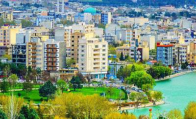
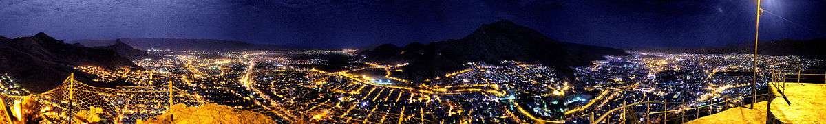
 Montage of Khorramabad, Clockwise:Falak-ol-Aflak Castle, Keeyow lake, Shapuri bridge, View of the Khorramabad city, Brick Minaret, Panorama of the Khorramabad | ||
| ||
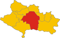 The territory of the Khorramabad inside the province of Lorestan | ||
 Khorramabad | ||
| Coordinates: 33°29′16″N 48°21′21″E / 33.48778°N 48.35583°ECoordinates: 33°29′16″N 48°21′21″E / 33.48778°N 48.35583°E | ||
| Country |
| |
| Province | Lorestan | |
| County | Khorramabad | |
| Bakhsh | Central | |
| Elevation | 1,147 m (3,763 ft) | |
| Population (2016 Census) | ||
| • Urban | 373,416 [1] | |
| Time zone | UTC+3:30 (IRST) | |
| • Summer (DST) | UTC+4:30 (IRDT) | |
| Climate | Csa | |
| Website | www.Khorramabad.ir | |
Khorramabad ![]()
The city population is predominantly Lur and Lak, although the two groups are closely related.[4] Although not a major tourist destination, it is quite scenic and possesses several attractions, such as five Paleolithic cave-dwelling sites.[5] In the city center, a tall citadel called Falak-ol-Aflak (The Heaven of Heavens), a relic of the Sassanid era, is now a nationally popular museum.
Economically, it is the regional base of the agricultural industry.
History
Pre-Islamic era

Khaydalu
Khaydalu was an important city of the Elam civilization. The city of Shapurkhast was built on the ruins of Khaydalu on the orders of Shapur I Sasanid. Many experts believes that the ancient city of Khaydalu was the core of modern Khorramabad.
Shapurkhast
In the texts of historians Shapurkhast has been considered one of the most important and developed cities of the region during this period. Falak-ol-Aflak castle ( Dež-e Shāpūr-Khwāst) was built by Shapur I the Sasanid.
Islamic era
Probably in the late seventh century CE, Shapurkhast was destroyed and the people of Shapurkhast moved to the western part of Falak-ol-Aflak Castle, which offered plenty of water as well as safety.
Hamdallah Mustawfi writes: Khorramabad was a beautiful city, now it is destroyed.
Hazaraspids
The founder of the Hazaraspid dynasty was Abu Tahir ibn Muhammad, a descendant of the Shabankara chieftain Fadluya. Fadluya was initially a commander of the Salghurids of Fars and was appointed governor of Kuhgiluya[6] but eventually gained independence in Luristan and extended his realm as far as Isfahan. He assumed the prestigious title of atabeg.
Safavid dynasty
During the reign of the Safavid dynasty, Khorramabad was the administrative center of Luristan Province. In the wake of the demise of the Safavids, after the signing of the Treaty of Constantinople (1724) with Imperial Russia, the Ottomans conquered Khorramabad on 6 September 1725.[7]
Qajar dynasty
In this period, the city of Khorramabad was limited to environs of Falak-ol-Aflak Castle.This period was the beginning of a migration of people from small villages into Khorramabad. The increase in population led to the expansion of the city and the creation of new districts.
Pahlavi dynasty
Khorramabad Municipality was formed in 1913 and the first city council, consisting of seven members, was formed in 1916.
Geography and climate
Khorramabad has what is classed under the Köppen climate classification as a semi-arid (BSh) climate with continental influences, owing to its high altitude making it much wetter than lowland cities like Baghdad or cities more shielded from the Zagros Mountains like Esfahan and Tehran. It remains extremely hot in the summer even with very low humidity, but the winter is sufficiently wet for rainfed agriculture.
| Climate data for Khorramabad, Iran | |||||||||||||
|---|---|---|---|---|---|---|---|---|---|---|---|---|---|
| Month | Jan | Feb | Mar | Apr | May | Jun | Jul | Aug | Sep | Oct | Nov | Dec | Year |
| Record high °C (°F) | 24.0 (75.2) |
26.0 (78.8) |
31.0 (87.8) |
33.0 (91.4) |
41.0 (105.8) |
43.0 (109.4) |
47.0 (116.6) |
46.0 (114.8) |
43.0 (109.4) |
37.0 (98.6) |
30.0 (86) |
24.0 (75.2) |
47 (116.6) |
| Average high °C (°F) | 10.9 (51.6) |
13.3 (55.9) |
17.5 (63.5) |
22.6 (72.7) |
28.9 (84) |
36.0 (96.8) |
39.5 (103.1) |
39.1 (102.4) |
35.0 (95) |
27.7 (81.9) |
19.7 (67.5) |
13.1 (55.6) |
25.3 (77.5) |
| Daily mean °C (°F) | 5.0 (41) |
7.1 (44.8) |
11.0 (51.8) |
15.7 (60.3) |
21.2 (70.2) |
27.0 (80.6) |
30.8 (87.4) |
29.8 (85.6) |
25.3 (77.5) |
19.1 (66.4) |
12.3 (54.1) |
6.9 (44.4) |
17.6 (63.7) |
| Average low °C (°F) | 0.1 (32.2) |
1.4 (34.5) |
4.6 (40.3) |
8.3 (46.9) |
11.9 (53.4) |
15.4 (59.7) |
19.5 (67.1) |
18.7 (65.7) |
14.1 (57.4) |
10.0 (50) |
5.5 (41.9) |
1.8 (35.2) |
9.3 (48.7) |
| Record low °C (°F) | −14.6 (5.7) |
−11.0 (12.2) |
−11 (12) |
−2.0 (28.4) |
−1.8 (28.8) |
7.0 (44.6) |
9.2 (48.6) |
8.0 (46.4) |
4.6 (40.3) |
−1.4 (29.5) |
−7.8 (18) |
−8.6 (16.5) |
−14.6 (5.7) |
| Average precipitation mm (inches) | 86.0 (3.386) |
73.1 (2.878) |
82.5 (3.248) |
71.6 (2.819) |
36.5 (1.437) |
0.3 (0.012) |
0.1 (0.004) |
0.2 (0.008) |
1.2 (0.047) |
23.5 (0.925) |
54.3 (2.138) |
83.6 (3.291) |
512.9 (20.193) |
| Average rainy days | 11.9 | 10.7 | 12.9 | 11.0 | 6.2 | 0.4 | 0.3 | 0.2 | 0.4 | 4.8 | 7.6 | 10.1 | 76.5 |
| Average snowy days | 2.6 | 1.5 | 0.7 | 0 | 0 | 0 | 0 | 0 | 0 | 0 | 0.1 | 0.9 | 5.8 |
| Average relative humidity (%) | 69 | 64 | 58 | 54 | 43 | 28 | 24 | 25 | 28 | 39 | 55 | 66 | 46.1 |
| Mean monthly sunshine hours | 163.4 | 170.8 | 187.2 | 206.0 | 264.2 | 340.4 | 347.2 | 330.1 | 302.7 | 257.3 | 191.4 | 160.5 | 2,921.2 |
| Source: NOAA (1961-1990) [8] | |||||||||||||
Main sights
Falak-ol-Aflak Castle
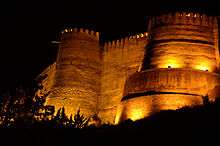
Falak-ol-Aflak Castle, Dež-e Shāpūr-Khwāst, Falak-ol-Aflak Castle, known in ancient times as Dezbaz as well as Shapur-Khast, is one of the most impressive castles in Iran. It is situated on the top of a large hill with the same name within the city of Khorramabad, the regional capital of Lorestan province. The Khorramabad River runs past the eastern and south-western side of the Falak-ol-Aflak hill providing the fortress with an element of natural protection. Today, the western and northern sides of the hill are bordered by the residential districts of Khorramabad. This gigantic structure was built during the Sassanid era (226–651). It has been known by a number of names since it was built over 1800 years ago. Recorded names have referred to it as Shapur-Khast or Sabr-Khast fortress, Dezbaz, Khorramabad castle, and ultimately the Falak ol-Aflak Castle. The foundations of the actual castle measure approximately 300 meters by 400 meters. The height of the entire structure, including the hill, reaches up to 40 meters above the surrounding area. This space is divided into four large halls, and their associated rooms and corridors. The rooms all surround two courtyards with the following measurements: the first courtyard measures 31×22.50 meters and the second 29x21 meters. . When originally built the castle used to have 12 towers, but only 8 remain standing today. The building's entrance is situated towards the north, within the body of the north-western tower.
Gerdab sangi
Gerdab Sangi is located in Takhti Square in Khorramabad, Lorestan and is made of stones and plaster. It dates back to the Sassanid era (224-651 CE) and is a circular whirlpool built for the purpose of accurate and optimal distribution of water. Encircling several springs, the edifice sits near the prehistoric Qomri Cave. The construction was once used for rationing and distributing potable and agricultural water among local population and farmers. Its surrounding cylindrical stone wall has a height of 10 meters and a diameter of 18 meters. There are a few different-sized outlets in the wall for controlling the flow of water into a canal on the west of the structure. While originally there were 7 of such outlets, however, today only one is functional. This outlet measures 160 x 90 centimeters and opens and closes like a drawer. The water flowing out of this outlet, after a path of approximately 12 kilometers, would eventually make its way to a valley called Baba Abbas. In the vicinity of this valley, and the location of the ancient city of Shapurkhast, the remnants of an old mill, which was run using water from the springs, can be observed. Gerdab Sangi was registered on the National Heritage List in 1976.
Brick minaret
Brick Minaret is a 900-year-old brick tower located beside the ancient city of Shapur khawst, south of Khorramabad, Lorestan province. It was built as a guidepost for caravans in ancient times. The minaret is about 30 meters tall with a circumference of 17.5 meters. Inside the tower there is a spiral staircase of 99 stairs.
Inscribed stone
In a stone-edged circle beside thundering Shari’ati St is an inscribed stone from around AD 1150, apparently setting out details of local grazing rights.
Shapoori bridge
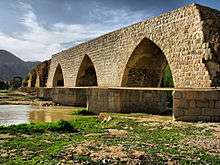
Shapoori Bridge is located in southern KhorramAbad. It has been used to connect the western part of Lorestan (Tarhan) to the east, and then on to Khoozestan province and Taysafun, the capital city of the Sassanian. The bridge is 312 meters long and 10.75 meters high. It has 28 arches and 27 piles. The area of each pile is 61 square meters, and the distance between the two piles is 7.5 meters. Five of its arches are intact; the others have been destroyed by natural factors. The arches of the bridge are made in the form of a wishbone. The piles and breakwaters of the bridge are in the form of six lateral lozenges made of stone. Probably the bridge also was used to distribute water. Materials of the bridge are river stones and stone chips in the arches and truncated stones in the piles. The bridge floor is paved in red block stones that have lost their square shape due to erosion. This attractive, huge bridge belongs to Sassanian era, and it is registered as number 1058 in the list of Iranian national monuments.
Akhoond Aboo house
Akhoond Aboo house is located in the west of Falak-ol-Aflak Castle, in Khorramabad.
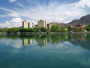
Keeyow lake
Keeyow lake is a natural lake located in the Northwest of Khorramabad. This lake spans a seven-hectare area and has a depth of 3 to 7 meters. There is an amusement park as well as other recreational facilities next to this lake. Keeyow lake, which is the only natural city lake in Iran, is a habitat for native and migratory Birds and Aquatic animals.[9]

Colleges and universities
Sister cities and twin towns
| Country | City | State / Province / Region / Governorate | Date | |||
|---|---|---|---|---|---|---|
| Turkey | Afyonkarahisar | Afyonkarahisar Province | 2015[13] | |||
| Japan | Yamagata | Yamagata Prefecture | October 2013[14] | |||
Photo gallery
 Nojian oak forest Khorramabad county
 Makhmalkuh Khorramabad county
 Kiu lake Khorramabad
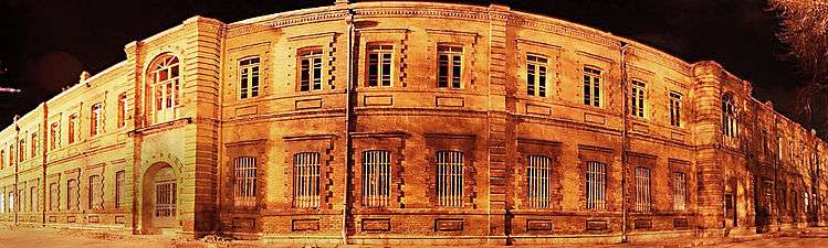 Sarbazkhane building - khorramabad
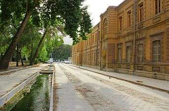 Building in Khorram abad
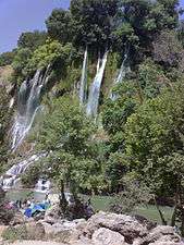 Bisheh waterfall Khorramabad county
 Khorramabad city Khorramabad county
See also
References
- ↑ https://www.amar.org.ir/english
- ↑ Khorramabad can be found at GEOnet Names Server, at this link, by opening the Advanced Search box, entering "-3071194" in the "Unique Feature Id" form, and clicking on "Search Database".
- ↑ "Census of the Islamic Republic of Iran, 1385 (2006)". Islamic Republic of Iran. Archived from the original (Excel) on 2011-11-11.
- ↑ Anonby, Erik John "Update on Luri: How many languages" JRAS (Journal of the Royal Asiatic Society) Series 3 13(2): pp. 171–197, p.183, doi:10.1017/S1356186303003067
- ↑ Baumler, Mark F. and Speth, John D. (1993) "A Middle Paleolithic Assemblage from Kunji Cave, Iran" pp. 1–74 In Olszewski, Deborah and Dibble, Harold Lewis (editors) (1993) The Paleolithic prehistory of the Zagros-Taurus The University Museum of Archaeology and Anthropology, University of Pennsylvania, Philadelphia, Pennsylvania, ISBN 978-0-924171-24-6
- ↑ B. Spuller,Atabakan-e Lorestan, Encyclopædia Iranica.
- ↑ Somel, Selcuk Aksin (2003). Historical Dictionary of the Ottoman Empire. Scarecrow Press. p. xlvi. ISBN 978-0810866065.
- ↑ "Khoram Abad Climate Normals 1961-1990". National Oceanic and Atmospheric Administration. Retrieved December 28, 2012.
- ↑ "دریاچه کیو خرمآباد تنها دریاچه طبیعی درونشهری ایران". Young Jouranalists Club. Retrieved 29 October 2017.
- ↑ Lorestan University" homepage, in English Archived September 20, 2010, at the Wayback Machine.
- ↑ "Lorestan University of Medical Sciences homepage". Lums.ac.ir. Retrieved 2012-09-12.
- ↑ "afpkh.ir". afpkh.ir. Archived from the original on 2012-09-11. Retrieved 2012-09-12.
- ↑ "Archived copy". Archived from the original on 2015-04-02. Retrieved 2015-03-02.
- ↑ "روزنامه كيهان88/2/14: لرستان و "ياماگاتاي" ژاپن خواهرخوانده شدند". www.magiran.com.
External links

- Khorramabad municipality
| Capital | 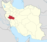 | ||||||||||||||||||||
|---|---|---|---|---|---|---|---|---|---|---|---|---|---|---|---|---|---|---|---|---|---|
| Counties and cities |
| ||||||||||||||||||||
| Sights |
| ||||||||||||||||||||
| populated places | |||||||||||||||||||||
| Styles |
|  | ||||||
|---|---|---|---|---|---|---|---|---|
| Types | ||||||||
| Elements | ||||||||
| Traditional cities | ||||||||
| Theory and analysis | ||||||||
| Lists |
| |||||||