Petropavlovsk-Kamchatsky
| Petropavlovsk-Kamchatsky Петропавловск-Камчатский (Russian) | |
|---|---|
| - City[1] - | |
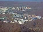   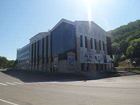  "Horizont" and "Severo-Vostok" microdistricts, Monument to Vitus Bering, building on Krasintsev st., Kamchatka drama and comedy theatre, Kamchatka Krai court on Leninskaya st. | |
 Petropavlovsk-Kamchatsky | |
 |
.png) |
Coat of arms |
Flag |
| City Day | October 17 |
| Administrative status (as of March 2010) | |
| Country | Russia |
| Federal subject | Kamchatka Krai |
| Administratively subordinated to | Petropavlovsk-Kamchatsky City Under Krai Jurisdiction[1] |
| Administrative center of | Kamchatka Krai,[1] Petropavlovsk-Kamchatsky City Under Krai Jurisdiction[1] |
| Municipal status (as of October 2004) | |
| Urban okrug | Petropavlovsk-Kamchatsky Urban Okrug[2] |
| Administrative center of | Petropavlovsk-Kamchatsky Urban Okrug[2] |
| Head | Sergey Kondrashin |
| Representative body | City Duma |
| Statistics | |
| Area | 362.14 km2 (139.82 sq mi) |
| Population (2010 Census) | 179,780 inhabitants[3] |
| - Rank in 2010 | 100th |
| Population (2013 est.) | 181,618 inhabitants |
| Density (2010) | 495/km2 (1,280/sq mi) |
| Time zone | PETT (UTC+12:00)[4] |
| Founded | October 17, 1740 |
| Previous names | Petropavlovsk (until 1924) |
| Postal code(s)[5] | 683000 (main) |
| Dialing code(s) | +7 4152 |
| Website |
pkgo |
| Petropavlovsk-Kamchatsky on Wikimedia Commons | |
Petropavlovsk-Kamchatsky (Russian: Петропа́вловск-Камча́тский, Russian pronunciation: [pʲɪtrɐˈpavləfsk kɐmˈtɕatskʲɪj]) is a city and the administrative, industrial, scientific, and cultural center of Kamchatka Krai, Russia. Population: 179,780 (2010 Census);[3] 198,028 (2002 Census);[6] 268,747 (1989 Census).[7]
Geography
The city is situated on high hills and surrounded by volcanoes. The surrounding terrain is mountainous enough that the horizon cannot be seen clearly from any point in town. Across Avacha Bay from the city in Vilyuchinsk is Russia's largest submarine base, the Rybachiy Nuclear Submarine Base, established during the Soviet period and still used by the Russian Navy.[8] The city is located 6,766 kilometers (4,204 mi) from Moscow and about 2,220 kilometers (1,380 mi) from Vladivostok.
History
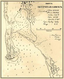
The city is considered to be founded by Danish navigator Vitus Bering in the service of the Russian Navy, although the foundation was laid by navigator Ivan Yelagin a few months earlier. Bering reached Avacha Bay in late 1740 and as superior, named the new settlement "Petropavlovsk" (Peter and Paul) after his two ships, the St. Peter and the St. Paul, built in Okhotsk for his second expedition. The town's location on the sheltered Avacha Bay and at the mouth of the Avacha River saw it develop to become the most important settlement in Kamchatka. It was granted town status on April 9, 1812.
During the 1854–1855 Crimean War, the city was put under siege by the Anglo-French forces, but never fell. The city had been fortified under the command of Nikolay Muravyov-Amursky in the years prior, but only possessed a small garrison of a few hundred soldiers and sixty-seven cannons. After much exchange of fire, 600 Anglo-French troops landed south of the city, but were forced to retreat by only 230 Russian troops after heavy fighting. One week later, 900 Anglo-French troops landed east of the town, but were again repelled by the Russians. The allied ships then retreated from Russian waters. The total Russian losses were reported at around 100 men; those of the Anglo-French at least five times that number.[9]
When the Japanese signed the surrendered United States Naval Construction Battalion 114 was in the Aleutians. In September 1945 the battalion was ordered to send a detachment to the USSR to build a Naval Advance Base (a Fleet Weather Central).[10] It was located 10 miles outside Petropavlovsk-Kamchatsky and was code named MOKO.[11] The original agreement gave the Seabees 3 weeks to complete the camp. Upon arrival the Russians told the Seabees they had 10 days and were amazed that the Seabees did it.[11] It was one of two that Stalin agreed to. The other was near Khabarousk, Siberia in buildings provided by the Russians.[11] For mail Petropavlovsk was assigned Navy number 1169, FPO San Francisco.[12]
Petropavlovsk was a great source of fish, particularly salmon, and crab meat for the Soviet Union in the 20th century. Since the end of the Soviet era, fishing rights have also been granted to foreign interests. Poaching of salmon for their caviar at Petropavlovsk-Kamchatsky remains a problem amid lax law enforcement and widespread corruption.[13]
Administrative and municipal status
Petropavlovsk-Kamchatsky is the administrative center of the krai.[1] Within the framework of administrative divisions, it is incorporated as Petropavlovsk-Kamchatsky City Under Krai Jurisdiction—an administrative unit with the status equal to that of the districts.[1] As a municipal division, Petropavlovsk-Kamchatsky City Under Krai Jurisdiction is incorporated as Petropavlovsk-Kamchatsky Urban Okrug.[2]
Tourism
The city has developed a tourist infrastructure. About twenty large tourism companies offer a wide range of services from bear hunting to paragliding. No roads connect the Kamchatka Peninsula to the rest of the world. Travel to Petropavlovsk-Kamchatsky is expensive but is growing in popularity because of the remarkable scenery throughout the peninsula. The city is served by Petropavlovsk-Kamchatsky Airport, which is linked to the town and its port via the A-401 road.
Demographics
Ethnic Russians make up the majority of the population; the city on its own has more inhabitants than the entire neighboring Chukotka Autonomous Okrug or Magadan Oblast.
The population numbered 179,780 in 2010; 179,800 in 2011; 179,784 in 2012; and 181,618 in 2013.
Climate
The climate is boreal (Köppen Dfc) and precipitation averages are estimated at 1,150 millimeters (45 in), or about three-and-a-half times as much as most of Siberia averages, with most falling as snow. Temperatures in winter are much milder than in Siberia—a typical January day averages −7 °C (19 °F), while in summer +16 °C (61 °F) constitutes an average August high. In warm years monthly high averages in July–August reach +18 °C (64 °F) and higher.[14]
Despite the generally high precipitation, the weather is less cloudy than in the adjacent Kuril Islands that are one of the least sunny places in the world,[15] since the city is located behind a peninsula to the north that blocks some of the fog from the Oyashio Current. Oceanic water in Avacha Bay and adjacent bays is also warmer than coastal waters of Kuril Islands and Okhotsk sea coast (except Southern Kuriles and Southern Sakhalin).
| Climate data for Petropavlovsk-Kamchatsky | |||||||||||||
|---|---|---|---|---|---|---|---|---|---|---|---|---|---|
| Month | Jan | Feb | Mar | Apr | May | Jun | Jul | Aug | Sep | Oct | Nov | Dec | Year |
| Record high °C (°F) | 4.4 (39.9) |
5.3 (41.5) |
6.8 (44.2) |
18.1 (64.6) |
20.6 (69.1) |
27.6 (81.7) |
30.0 (86) |
27.7 (81.9) |
24.4 (75.9) |
17.8 (64) |
12.6 (54.7) |
7.4 (45.3) |
30.0 (86) |
| Average high °C (°F) | −5.1 (22.8) |
−4.5 (23.9) |
−1.8 (28.8) |
2.1 (35.8) |
6.6 (43.9) |
11.9 (53.4) |
15.0 (59) |
15.9 (60.6) |
13.2 (55.8) |
7.8 (46) |
1.0 (33.8) |
−3.5 (25.7) |
4.9 (40.8) |
| Daily mean °C (°F) | −7.6 (18.3) |
−7.1 (19.2) |
−4.6 (23.7) |
−0.6 (30.9) |
3.4 (38.1) |
8.2 (46.8) |
11.5 (52.7) |
12.5 (54.5) |
9.7 (49.5) |
4.9 (40.8) |
−1.3 (29.7) |
−5.8 (21.6) |
1.9 (35.4) |
| Average low °C (°F) | −9.8 (14.4) |
−9.4 (15.1) |
−7 (19) |
−2.6 (27.3) |
1.2 (34.2) |
5.7 (42.3) |
9.3 (48.7) |
10.2 (50.4) |
7.1 (44.8) |
2.6 (36.7) |
−3.3 (26.1) |
−7.9 (17.8) |
−0.3 (31.5) |
| Record low °C (°F) | −28.6 (−19.5) |
−31.7 (−25.1) |
−24.8 (−12.6) |
−14.8 (5.4) |
−7.2 (19) |
−5.5 (22.1) |
2.5 (36.5) |
2.6 (36.7) |
−1.1 (30) |
−7.5 (18.5) |
−16.5 (2.3) |
−26 (−15) |
−31.7 (−25.1) |
| Average precipitation mm (inches) | 118 (4.65) |
80 (3.15) |
84 (3.31) |
90 (3.54) |
64 (2.52) |
53 (2.09) |
62 (2.44) |
91 (3.58) |
111 (4.37) |
174 (6.85) |
130 (5.12) |
109 (4.29) |
1,166 (45.91) |
| Average precipitation days | 18 | 17 | 17 | 16 | 14 | 14 | 16 | 16 | 13 | 16 | 15 | 16 | 188 |
| Average relative humidity (%) | 71 | 68 | 68 | 72 | 75 | 79 | 84 | 83 | 79 | 74 | 70 | 71 | 75 |
| Mean monthly sunshine hours | 105.4 | 115.8 | 176.7 | 192.0 | 192.2 | 192.0 | 170.5 | 176.7 | 177.0 | 158.1 | 123.0 | 93.0 | 1,872.4 |
| Source #1: Погода и климат [16] | |||||||||||||
| Source #2: Hong Kong Observatory [17] | |||||||||||||
Politics
Results of the Russian legislative elections
| Parties/Year | 2003 | 2007 | 2011 |
|---|---|---|---|
| Communist Party | 8.83% | 8.89% | 17.78% |
| Patriots of Russia (including former Party of Peace and Unity) |
0.35% | 2.31% | 2.53% |
| A Just Russia (including former Rodina or Motherland-National Patriotic Union Russian Party of Life People's Party of the Russian Federation and Russian Ecological Party "The Greens") |
13.91% | 7.41% | 9.93% |
| Yabloko (including former Union of People for education and research: "Партия СЛОН") |
8.92% | 1.85% | 5.10% |
| Right Cause (including former Citizens' Force Democratic Party of Russia and Union of Rightist Forces) |
4.46% | 2.74% | 0.67% |
| United Russia (including former Agrarian Party of Russia) |
35.29% | 61.78% | 43.59% |
| Liberal Democratic Party | 15.25% | 12.00% | 18.40% |
| Other minor parties | 12.12% |
Twin towns and sister cities
Petropavlovsk-Kamchatsky is twinned with:


Notable residents
- Pavlo Ishchenko, Ukrainian-Israeli Olympic boxer
- Anatolii Mohyliov, Ukrainian politician
- Sergei Ursuliak, Russian filmmaker, screenwriter and actor, and TV presenter
- Elena Yakovishina, Russian Olympic skier
Gallery
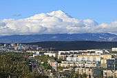
 Petropavlovsk and Koryaksky Volcano, as seen from Avacha Bay
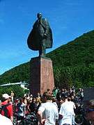 Lenin Square
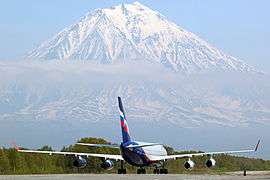 An Ilyushin Il-96-300 of Aeroflot at Petropavlovsk-Kamchatsky Airport
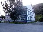
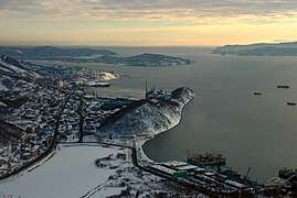 Original town center
 Seaport
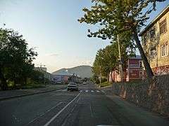 Sovetskaya Street
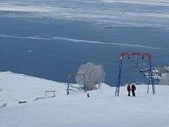 Ski resort "Red Hill" ("Krasnaya Sopka") in Petropavlovsk-Kamchatsky
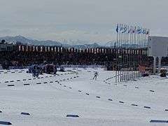 Petropavlovsk-Kamchatsky biathlon stadium. Vitaly Fatyanov prize competition.
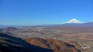 Aerial view of Petropavlovsk
 Aerial view of Petropavlovsk
 A Chapel, dedicated to those killed in the defense of the city in 1854.
References
- 1 2 3 4 5 6 Law #46
- 1 2 3 Law #220
- 1 2 Russian Federal State Statistics Service (2011). "Всероссийская перепись населения 2010 года. Том 1" [2010 All-Russian Population Census, vol. 1]. Всероссийская перепись населения 2010 года (2010 All-Russia Population Census) (in Russian). Federal State Statistics Service. Retrieved June 29, 2012.
- ↑ Правительство Российской Федерации. Федеральный закон №107-ФЗ от 3 июня 2011 г. «Об исчислении времени», в ред. Федерального закона №271-ФЗ от 03 июля 2016 г. «О внесении изменений в Федеральный закон "Об исчислении времени"». Вступил в силу по истечении шестидесяти дней после дня официального опубликования (6 августа 2011 г.). Опубликован: "Российская газета", №120, 6 июня 2011 г. (Government of the Russian Federation. Federal Law #107-FZ of June 31, 2011 On Calculating Time, as amended by the Federal Law #271-FZ of July 03, 2016 On Amending Federal Law "On Calculating Time". Effective as of after sixty days following the day of the official publication.).
- ↑ Почта России. Информационно-вычислительный центр ОАСУ РПО. (Russian Post). Поиск объектов почтовой связи (Postal Objects Search) (in Russian)
- ↑ Russian Federal State Statistics Service (May 21, 2004). "Численность населения России, субъектов Российской Федерации в составе федеральных округов, районов, городских поселений, сельских населённых пунктов – районных центров и сельских населённых пунктов с населением 3 тысячи и более человек" [Population of Russia, Its Federal Districts, Federal Subjects, Districts, Urban Localities, Rural Localities—Administrative Centers, and Rural Localities with Population of Over 3,000] (XLS). Всероссийская перепись населения 2002 года [All-Russia Population Census of 2002] (in Russian). Retrieved August 9, 2014.
- ↑ Demoscope Weekly (1989). "Всесоюзная перепись населения 1989 г. Численность наличного населения союзных и автономных республик, автономных областей и округов, краёв, областей, районов, городских поселений и сёл-райцентров" [All Union Population Census of 1989: Present Population of Union and Autonomous Republics, Autonomous Oblasts and Okrugs, Krais, Oblasts, Districts, Urban Settlements, and Villages Serving as District Administrative Centers]. Всесоюзная перепись населения 1989 года [All-Union Population Census of 1989] (in Russian). Институт демографии Национального исследовательского университета: Высшая школа экономики [Institute of Demography at the National Research University: Higher School of Economics]. Retrieved August 9, 2014.
- ↑ "Archived copy". Archived from the original on November 6, 2011. Retrieved December 11, 2011.
- ↑ Black, Jeremy (2001). Western warfare 1775-1882. Bloomington: Indiana University Press. p. 80. ISBN 978-0253214720.
- ↑ The 114th CB cruisebook, 1946, U.S.Navy Seabee Museum Archives, Port Hueneme, Ca, p.123-125
- 1 2 3 Yanks in Siberia: U.S. Navy Weather Stations in Soviet East Asia, 1945, G. Patrick March, Pacific Historical Review, Vol. 57, No. 3 (Aug., 1988), pp. 327-342, Published by: University of California Press.
- ↑ US Navy Abbreviations of World War II,The Navy Department Library, U.S. Navy web site, Published:Thu Jul 23 14:45:40 EDT 2015
- ↑ Feifer, Gregory (July 22, 2007). "Poaching in Far Eastern Russia Threatens Ecosystem". NPR. Archived from the original on May 9, 2015. Retrieved June 29, 2014.
- ↑ "Archived copy". Archived from the original on June 1, 2012. Retrieved December 2, 2011. Pogoda.ru.net
- ↑ See Climatological Norms of Simusir Island Archived September 24, 2012, at the Wayback Machine.
- ↑ Погода и климат. "Archived copy". Archived from the original on October 1, 2011. Retrieved October 6, 2011. . Retrieved on: April 8, 2010.
- ↑ Climatological Norms of Petropavlovsk-Kamchatsky "Archived copy". Archived from the original on September 10, 2010. Retrieved August 24, 2011. . Retrieved on: August 24, 2011.
- ↑ Russian presence in Japan Archived March 7, 2005, at the Wayback Machine.
- ↑ "Archived copy". Archived from the original on October 2, 2011. Retrieved November 8, 2010.
- ↑ Alaska - Kamchatka Connections Archived February 20, 2012, at the Wayback Machine.
Sources
- Законодательное Собрание Камчатского края. Закон №46 от 29 апреля 2008 г. «Об административно-территориальном устройстве Камчатского края», в ред. Закона №659 от 30 июля 2015 г. «О внесении изменения в статью 5 Закона Камчатского края "Об административно-территориальном устройстве Камчатского края"». Вступил в силу со дня официального опубликования. Опубликован: "Официальные Ведомости", №65-69, 6 мая 2008 г. (Legislative Assembly of Kamchatka Krai. Law #46 of April 29, 2008 On the Administrative-Territorial Structure of Kamchatka Krai, as amended by the Law #659 of July 30, 2015 On Amending Article 5 of the Law of Kamchatka Krai "On the Administrative-Territorial Structure of Kamchatka Krai". Effective as of the day of the official publication.).
- Совет народных депутатов Камчатской области. Закон №220 от 20 октября 2004 г. «О наделении Петропавловск-Камчатского городского муниципального образования статусом городского округа и об установлении границ Петропавловск-Камчатского городского округа». Вступил в силу со дня официального опубликования. Опубликован: "Официальные Ведомости", №77–78, 16 декабря 2004 г. (Council of People's Deputies of Kamchatka Oblast. Law #220 of October 20, 2004 On Granting Urban Okrug Status to Petropavlovsk-Kamchatsky Urban Municipal Formation and on Establishing the Borders of Petropavlovsk-Kamchatsky Urban Okrug. Effective as of the day of the official publication.).
External links
![]()
- Official website of Petropavlovsk-Kamchatsky (in Russian)
- New photos of the city (in Russian)
- Photos of Kamchatka (in Russian)
- News of Petropavlovsk-Kamchatsky and Kamchatka Krai (in Russian)
- Petropavlovsk-Kamchatsky Internet portal (in Russian)
- History of the city of Petropavlovsk-Kamchatsky (in Russian)