Murcia
| Murcia | |||
|---|---|---|---|
| Municipality | |||
 | |||
| |||
 Murcia  Murcia | |||
| Coordinates: 37°59′10″N 1°7′49″W / 37.98611°N 1.13028°WCoordinates: 37°59′10″N 1°7′49″W / 37.98611°N 1.13028°W | |||
| Country |
| ||
| Autonomous community |
| ||
| Province | Murcia | ||
| Comarca | Huerta de Murcia | ||
| Judicial district | Murcia | ||
| Founded | 825 | ||
| Government | |||
| • Mayor | José Ballesta Germán (2015) (PP) | ||
| Area | |||
| • Municipality | 881.86 km2 (340.49 sq mi) | ||
| Elevation | 43 m (141 ft) | ||
| Population (2010) | |||
| • Municipality | 442,573 | ||
| • Density | 500/km2 (1,300/sq mi) | ||
| • Urban | 502,000[1] | ||
| Demonym(s) | Murciano/a | ||
| Time zone | UTC+1 (CET) | ||
| • Summer (DST) | UTC+2 (CEST) | ||
| Postal code | 30001 to 30012 | ||
| Dialing code | 968 / 868 | ||
| Website | Official website | ||


Murcia (/ˈmʊərsiə/ or /ˈmɜːrʃə/, Spanish: [ˈmuɾθja]) is a city in south-eastern Spain, the capital and most populous city of the Autonomous Community of the Region of Murcia, and the seventh largest city in the country, with a population of 442,573 inhabitants in 2009 (about one third of the total population of the Region). The population of the metropolitan area was 689,591 in 2010. It is located on the Segura River, in the Southeast of the Iberian Peninsula, noted by a climate with hot summers, mild winters, and relatively low precipitation.
Murcia was founded by the emir of Cordoba Abd ar-Rahman II in 825 with the name Mursiyah (Arabic: مرسية). Nowadays, it is mainly a services city and a university town. Highlights for visitors include the Cathedral of Murcia and a number of baroque buildings, renowned local cuisine, Holy Week procession works of art by the famous Murcian sculptor Francisco Salzillo, and the Fiestas de Primavera (Spring Festival).
The city, as the capital of the comarca Huerta de Murcia is called Europe's orchard due to its long agricultural tradition and its fruit, vegetable, and flower production and exports.
Murcia is located near the center of a low-lying fertile plain known as the huerta (orchard or vineyard) of Murcia. The Segura River and its right-hand tributary, the Guadalentín, run through the area. The city has an elevation of 43 metres (141 ft) above sea level and its municipality covers approximately 882 square kilometres (341 sq mi).
The best known and most dominant aspect of the municipal area's landscape is the orchard. In addition to the orchard and urban zones, the great expanse of the municipal area is made up of different landscapes: badlands, groves of Carrasco pine trees in the precoastal mountain ranges and, towards the south, a semi-steppe region. A large natural park, the Parque Regional de Carrascoy y el Valle, lies just to the south of the city.
History

It is widely believed that Murcia's name is derived from the Latin words of Myrtea or Murtea, meaning land of Myrtle (the plant is known to grow in the general area), although it may also be a derivation of the word Murtia, which would mean Murtius Village (Murtius was a common Roman name). Other research suggests that it may owe its name to the Latin Murtae (Mulberry), which covered the regional landscape for many centuries. The Latin name eventually changed into the Arabic Mursiya, and then, Murcia.
The city in its present location was founded with the name Madinat Mursiyah (city of Murcia) in AD 825 by Abd ar-Rahman II, who was then the emir of Córdoba.[2] Umayyad planners, taking advantage of the course of the river Segura, created a complex network of irrigation channels that made the town's agricultural existence prosperous. In the 12th century the traveler and writer Muhammad al-Idrisi described the city of Murcia as populous and strongly fortified. After the fall of the Caliphate of Cordoba in 1031, Murcia passed under the successive rules of the powers seated variously at Almería and Toledo, but finally became capital of its own kingdom with Ibn Tahir.[2] After the fall of Almoravide empire, Muhammad Ibn Mardanis made Murcia the capital of a new independent kingdom. At this time, Murcia was a very prosperous city, famous for its ceramics, exported to Italian towns, as well as for silk and paper industries, the first in Europe. The coinage of Murcia was considered as model in all the continent. The mystic Ibn Arabi (1165–1240)[3] and the poet Ibn al-Jinan (d.1214) were born in Murcia during this period.
In 1172 Murcia was conquered by the north African based Almohades, the last Muslim empire to rule southern Spain,[4] and as the forces of the Christian Reconquista gained the upper hand, was the capital of a small Muslim emirate from 1223 to 1243. By the treaty of Alcaraz, in 1243, the Christian king Ferdinand III of Castile made Murcia a protectorate, getting access to the Mediterranean sea while Murcia was protected against Granada and Aragon.[4] The Christian population of the town became the majority as immigrants poured in from almost all parts of the Iberian Peninsula. Christian immigration was encouraged with the goal of establishing a loyal Christian base. These measures led to the Muslim popular revolt in 1264, which was quelled by James I of Aragon in 1266, conquering Murcia and bringing Aragonese and Catalan immigrants with him.
After this, during the reign of Alfonso X of Castile, Murcia was one of his capitals with Toledo and Seville.
The Murcian duality: Catalan population in a Castillian territory, brought the subsequent conquest of the city by James II of Aragon in 1296. In 1304, Murcia was finally incorporated into Castile under the Treaty of Torrellas.[5]
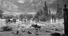
Murcia's prosperity declined as the Mediterranean lost trade to the ocean routes and from the wars between the Christians and the Ottoman Empire. The old prosperity of Murcia became crises during 14th century because of its border location with the neighbouring Muslim kingdom of Granada, but flourished after its conquest in 1492 and again in the 18th century, benefiting greatly from a boom in the silk industry. Most of the modern city's landmark churches, monuments and old architecture date from this period. In this century, Murcia lived an important role in Bourbon victory in the War of the Spanish Succession, thanks to the Cardinal Belluga. In 1810, Murcia was looted by Napoleonic troops; it then suffered a major earthquake in 1829. According to contemporaneous accounts, an estimated 6,000 people died from the disaster's effects across the province. Plague and cholera followed.
The town and surrounding area suffered badly from floods in 1651, 1879, and 1907, though the construction of a levee helped to stave off the repeated floods from the Segura. A popular pedestrian walkway, the Malecon, runs along the top of the levee.
Murcia has been the capital of the province of Murcia since 1833 and, with its creation by the central government in 1982, capital of the autonomous community (which includes only the city and the province). Since then, it has become the seventh most populated municipality in Spain, and a thriving services city.
The 5.1 Mw Lorca earthquake shook the Region of Murcia with a maximum Mercalli intensity of VII (Very strong) on May 11, 2011. Nine people were killed and over 400 were injured.
Geography and climate
Segura River
The Segura River crosses an alluvial plain (Vega Media del Segura), part of a Mediterranean pluvial system. The river crosses the city from west to east. Its volumetric flow is mostly small but the river is known to produce occasional flooding, like those that inundated the capital in 1946, 1948, 1973 or 1989. The Segura was recognized as one of the most polluted rivers in Europe.[6]

Mountains and hills
The Segura river's Valley is surrounded by two mountain ranges, the hills of Guadalupe, Espinardo, Cabezo de Torres, Esparragal and Monteagudo in the north and the Cordillera Sur in the south. The municipality itself is divided into southern and northern zones by a series of mountain ranges, the aforementioned Cordillera Sur (Carrascoy, El Puerto, Villares, Columbares, Altaona, and Escalona). These two zones are known as Field of 'Murcia (in the south of Cordillera Sur) and Orchard of Murcia (the Segura Valley in the north of Cordillera Sur). Near the plain's center, the steep hill of Monteagudo protrudes dramatically.
Districts
The 881.86-square-kilometre (340.49 sq mi) territory of Murcia's municipality is made up of 54 pedanías (suburban districts) and 28 barrios (city neighbourhood districts).[7] The barrios make up the 12.86-square-kilometre (4.97 sq mi) the main urban portion of the city. The historic city center is approximately 3 square kilometres (1 sq mi) of the urbanized downtown portion of Murcia.
| District | Population[8] |
|---|---|
| La Albatalía | 2,023 |
| La Alberca | 12,528 |
| Aljucer | 7,620 |
| Alquerías | 6,033 |
| La Arboleja | 2,079 |
| Baños y Mendigo | 581 |
| Barqueros | 1,047 |
| Beniaján | 10,916 |
| Cabezo de Torres | 12,885 |
| Cañada Hermosa | 189 |
| Cañadas de San Pedro | 340 |
| Carrascoy | 96 |
| Casillas | 4,743 |
| Churra | 7,614 |
| Cobatillas | 2,508 |
| Corvera | 2,457 |
| Los Dolores | 4,787 |
| Era Alta | 3,090 |
| El Esparragal | 7,188 |
| Garre y Lages | 7,393 |
| Gea y Truyols | 1,055 |
| Javalí Nuevo | 3,253 |
| Javalí Viejo | 2,255 |
| Jerónimo y Avileses y Balsicas de Arriba | 1,470 |
| Lobosillo | 1,930 |
| Llano de Brujas | 5,639 |
| Los Martínez del Puerto | 821 |
| Monteagudo | 3,861 |
| Nonduermas | 2,290 |
| La Ñora | 4,802 |
| El Palmar | 23,107 |
| Puebla de Soto | 1,765 |
| Puente Tocinos | 16,418 |
| El Puntal | 6,622 |
| El Raal | 6,311 |
| Los Ramos | 3,290 |
| La Raya | 2,221 |
| Rincón Beniscornia | 939 |
| Rincón de Seca | 2,232 |
| San Benito | 13,900 |
| San Ginés | 2,598 |
| San José de la Vega | 4,605 |
| Sangonera la Seca | 5,521 |
| Sangonera la Verde | 11,296 |
| Santa Cruz | 2,543 |
| Santiago y Zaraiche | 9,827 |
| Santo Ángel | 4,851 |
| Sucina | 2,014 |
| Torreagüera | 8,853 |
| Valladolises y Lo Jurado | 687 |
| Zarandona | 6,817 |
| Zeneta | 1,793 |
Climate
Murcia has a hot semi-arid climate (Köppen climate classification: BSh).[9] Given its proximity to the Mediterranean Sea, it has mild winters and hot summers.
It averages more than 320 days of sun per year[10]. Occasionally, Murcia has heavy rains where the precipitation for the entire year will fall over the course of a few days.
In the coldest month, January, the average temperature range is a high of 16.6 °C (62 °F) during the day and a low of 4.7 °C (40 °F) at night. In the warmest month, August, the range goes from 34.2 °C (94 °F) during the day to 20.9 °C (70 °F) at night. Temperatures almost always reach or exceed 40 °C (104 °F) on at least one or two days per year. In fact, Murcia holds close to the highest recorded in southern Europe since reliable meteorological records commenced in 1950. The official record for Murcia stands at 47.2 °C (117.0 °F), at Alcantarilla airport in the western suburbs on July 4, 1994 with 45.7 °C (114.3 °F) being recorded at a station near the city centre on the same day, being only lower than the 47.4 °C measured in Amareleja, Portugal.
| Climate data for Murcia (1981–2010), extremes (1930–) | |||||||||||||
|---|---|---|---|---|---|---|---|---|---|---|---|---|---|
| Month | Jan | Feb | Mar | Apr | May | Jun | Jul | Aug | Sep | Oct | Nov | Dec | Year |
| Record high °C (°F) | 26.0 (78.8) |
29.4 (84.9) |
33.6 (92.5) |
37.4 (99.3) |
40.1 (104.2) |
42.5 (108.5) |
47.2 (117) |
43.2 (109.8) |
44.6 (112.3) |
34.9 (94.8) |
31.0 (87.8) |
25.8 (78.4) |
47.2 (117) |
| Average high °C (°F) | 16.6 (61.9) |
18.4 (65.1) |
20.9 (69.6) |
23.3 (73.9) |
26.6 (79.9) |
31.0 (87.8) |
34.0 (93.2) |
34.2 (93.6) |
30.4 (86.7) |
25.6 (78.1) |
20.3 (68.5) |
17.2 (63) |
24.9 (76.8) |
| Daily mean °C (°F) | 10.6 (51.1) |
12.2 (54) |
14.3 (57.7) |
16.5 (61.7) |
20.0 (68) |
24.2 (75.6) |
27.2 (81) |
27.6 (81.7) |
24.2 (75.6) |
19.8 (67.6) |
14.6 (58.3) |
11.5 (52.7) |
18.6 (65.5) |
| Average low °C (°F) | 4.7 (40.5) |
5.9 (42.6) |
7.7 (45.9) |
9.7 (49.5) |
13.3 (55.9) |
17.4 (63.3) |
20.3 (68.5) |
20.9 (69.6) |
18.0 (64.4) |
13.9 (57) |
8.9 (48) |
5.8 (42.4) |
12.3 (54.1) |
| Record low °C (°F) | −7.5 (18.5) |
−3.9 (25) |
−2.4 (27.7) |
0.0 (32) |
4.0 (39.2) |
8.0 (46.4) |
13.0 (55.4) |
14.0 (57.2) |
9.6 (49.3) |
4.4 (39.9) |
−1.0 (30.2) |
−6.0 (21.2) |
−7.5 (18.5) |
| Average precipitation mm (inches) | 27 (1.06) |
27 (1.06) |
30 (1.18) |
25 (0.98) |
28 (1.1) |
18 (0.71) |
3 (0.12) |
8 (0.31) |
32 (1.26) |
36 (1.42) |
32 (1.26) |
29 (1.14) |
297 (11.69) |
| Average precipitation days (≥ 1 mm) | 4 | 4 | 3 | 4 | 4 | 2 | 1 | 1 | 3 | 4 | 4 | 4 | 37 |
| Average relative humidity (%) | 65 | 63 | 59 | 53 | 52 | 49 | 50 | 54 | 59 | 64 | 65 | 68 | 58 |
| Mean monthly sunshine hours | 189 | 190 | 223 | 256 | 289 | 323 | 353 | 317 | 239 | 217 | 186 | 172 | 2,967 |
| Source: Agencia Estatal de Meteorología[11] | |||||||||||||
| Climate data for Murcia—San Javier (Airport 4 m, near sea) (1981–2010), extremes (1930–) | |||||||||||||
|---|---|---|---|---|---|---|---|---|---|---|---|---|---|
| Month | Jan | Feb | Mar | Apr | May | Jun | Jul | Aug | Sep | Oct | Nov | Dec | Year |
| Record high °C (°F) | 26.2 (79.2) |
27.8 (82) |
30.0 (86) |
32.0 (89.6) |
34.5 (94.1) |
36.9 (98.4) |
40.5 (104.9) |
40.0 (104) |
39.4 (102.9) |
35.5 (95.9) |
30.0 (86) |
27.0 (80.6) |
40.5 (104.9) |
| Average high °C (°F) | 16.0 (60.8) |
16.7 (62.1) |
18.5 (65.3) |
20.4 (68.7) |
22.9 (73.2) |
26.4 (79.5) |
28.9 (84) |
29.5 (85.1) |
27.5 (81.5) |
24.0 (75.2) |
19.8 (67.6) |
17.6 (63.7) |
22.3 (72.1) |
| Daily mean °C (°F) | 10.8 (51.4) |
11.6 (52.9) |
13.4 (56.1) |
15.3 (59.5) |
18.4 (65.1) |
22.2 (72) |
24.8 (76.6) |
25.5 (77.9) |
23.2 (73.8) |
19.4 (66.9) |
14.9 (58.8) |
11.9 (53.4) |
17.6 (63.7) |
| Average low °C (°F) | 5.5 (41.9) |
6.5 (43.7) |
8.4 (47.1) |
10.2 (50.4) |
13.8 (56.8) |
17.9 (64.2) |
20.7 (69.3) |
21.5 (70.7) |
18.9 (66) |
14.7 (58.5) |
10.0 (50) |
6.8 (44.2) |
12.9 (55.2) |
| Record low °C (°F) | −3.8 (25.2) |
−4.0 (24.8) |
−3.0 (26.6) |
1.0 (33.8) |
4.8 (40.6) |
9.5 (49.1) |
11.0 (51.8) |
12.0 (53.6) |
7.9 (46.2) |
4.0 (39.2) |
−1.5 (29.3) |
−5.4 (22.3) |
−5.4 (22.3) |
| Average precipitation mm (inches) | 42 (1.65) |
27 (1.06) |
24 (0.94) |
23 (0.91) |
25 (0.98) |
7 (0.28) |
2 (0.08) |
7 (0.28) |
39 (1.54) |
39 (1.54) |
47 (1.85) |
30 (1.18) |
313 (12.32) |
| Average precipitation days (≥ 1 mm) | 4 | 3 | 3 | 3 | 3 | 1 | 0 | 1 | 3 | 4 | 4 | 4 | 33 |
| Mean monthly sunshine hours | 173 | 171 | 206 | 224 | 266 | 288 | 307 | 283 | 224 | 200 | 162 | 156 | 2,621 |
| Source: Agencia Estatal de Meteorología[11] | |||||||||||||
Demographics
Murcia has 433,850 inhabitants (INE 2008) making it the seventh-largest Spanish municipality by population. When adding in the municipalities of Alcantarilla, Alguazas, Beniel, Molina de Segura, Santomera, and Las Torres de Cotillas, the metropolitan area has 564,036 inhabitants making it the twelfth most populous metropolitan area in Spain. Nevertheless, due to Murcia's large municipal territory, its population density (472 hab./km², 760 hab./sq.mi.) does not likewise rank among Spain's highest.
According to the official population data of the INE, 10% of the population of the municipality reported belonging to a foreign nationality as of 2005.
The majority of the population identify as Christian. There is also a sizeable Muslim population as well as a growing Jewish community.
Main sights
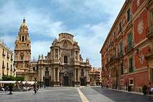
The Cathedral of Murcia was built between 1394 and 1465 in the Castilian Gothic style. Its tower was completed in 1792 and shows a blend of architectural styles. The first two stories were built in the Renaissance style (1521–1546), while the third is Baroque. The bell pavilion exhibits both Rococo and Neoclassical influences. The main façade (1736–1754) is considered a masterpiece of the Spanish Baroque style.[13]

Other noteworthy buildings in the square shared by the Cathedral (Plaza Cardinal Belluga) are the colorful Bishop's Palace (18th century) and a controversial extension to the town hall by Rafael Moneo (built in 1999).
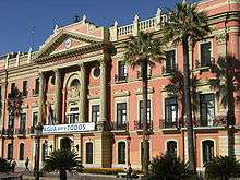
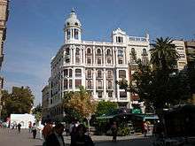
The Glorieta, which lies on the banks of the Segura River, has traditionally been the center of the town. It is a pleasant, landscaped city square that was constructed during the 18th century. The ayuntamiento (city hall) of Murcia is located in this square.
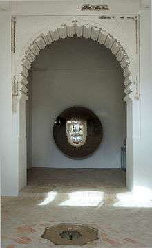
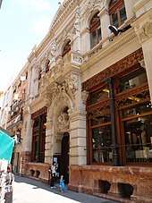
Pedestrian areas cover most of the old town of the city, which is centered around Platería and Trapería Streets. Trapería goes from the Cathedral to the Plaza de Santo Domingo, formerly a bustling market square. Located in Trapería is the Casino, a social club erected in 1847, with a sumptuous interior that includes a Moorish-style patio inspired by the royal chambers of the Alhambra near Granada. The name Plateria refers to plata (silver), as this street was the historical focus for the commerce of rare metals by Murcia's Jewish community. The other street, Traperia, refers to trapos, or cloths, as this was once the focus for the Jewish community's garment trade.
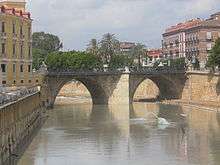
Several bridges of different styles span the river Segura, from the Puente de los Peligros, 18th century stone bridge with a Lady chapel on one of its sides; to modern bridges designed by Santiago Calatrava or Javier Manterola; through others such as the Puente Nuevo, an iron bridge of the early 20th century.

Other notable places around Murcia include:[14][15]
- Santa Clara monastery, a Gothic and Baroque monument where is located a museum with the Moorish palace's remains from the 13th century, called Alcázar Seguir.
- The Malecón boulevard, a former retaining wall for the Río Segura's floods.
- La Fuensanta sanctuary and adjacent El Valle regional park
- Los Jerónimos monastery (18th century)
- Romea theatre (19th century)
- Almudí Palace (17th century), a historic building with coats of arms on its façade. On its interior there are Tuscan columns, and since 1985 it hosts the city archives and usually houses exhibitions.
- Monteagudo Castle (11th century)
- Salzillo Museum
- San Juan de Dios church-museum, Baroque and Rococo circular church with the remains of the Moorish palace mosque from the 12th century in the basement, called Alcázar Nasir.
In the metropolitan area are also the Azud de la Contraparada reservoir and the Noria de La Ñora water wheel.
Festivals
.jpg)
The Holy Week procession hosted by the city is among the most famous throughout Spain. This traditional festival portrays the events which lead up to and include the Crucifixion according to the New Testament. Life-sized, finely detailed sculptures by Francisco Salzillo (1707–1783) are removed from their museums and carried around the city in elegant processions amid flowers and, at night, candles, pausing at stations which are meant to re-enact the final moments before the crucifixion of Jesus.[16]
The most colorful festival in Murcia may come one week after Holy Week, when locals dress up in traditional huertano clothing to celebrate the Bando de la Huerta (Orchard parade) on Tuesday and fill the streets for The Burial of the Sardine in Murcia. parade the following Saturday. This whole week receives the name of Fiestas de Primavera (Spring Fest).[17]
Murcia's Three Cultures International Festival happens each May and was first organized with the intent of overcoming racism and xenophobia in the culture. The festival seeks to foster understanding and reconciliation between the three cultures that have cohabited the peninsula for centuries, if not millennia: Christians, Jews and Muslims. Each year, the festival celebrates these three cultures through music, exhibitions, symposiums and conferences.[18]
Economy
Economically, Murcia predominantly acts as a centre for agriculture and tourism. It is common to find Murcia's tomatoes and lettuce, and especially lemons and oranges, in European supermarkets. Murcia is a producer of wines, with about 40,000 hectares (100,000 acres) devoted to grape vineyards. Most of the vineyards are located in Ricote and Jumilla. Jumilla is a plateau where the vineyards are surrounded by mountains.
Murcia has some industry, with foreign companies choosing it as a location for factories, such as Henry Milward & Sons (which manufactures surgical and knitting needles) and American firms like General Electric and Paramount Park Studios.
During the 2000s, the economy of the region turned towards "residential tourism" in which people from northern European countries have a second home in the area. Europeans and Americans are able to learn Spanish in the academies in the town center.
The economy of Murcia is supported by fairs and congresses, museums, theatres, cinema, music, aquariums, bullfighting, restaurants, hotels, camping, sports, foreign students, and tourism.
Transportation
- By plane
Murcia-San Javier Airport (MJV) is located on the edge of the Mar Menor close to the town of San Javier, 45 kilometres (28 miles) southeast of Murcia. There is also an airport at the neighboring city of Alicante 70 km (43 miles) from Murcia. Furthermore, there is a new airport in development to be located in the town of Corvera, 23 km (14 miles).
- By bus
Bus service is provided by LatBus, which operates the interurban services. Urban bus services is offered by a new operator, TM(Transportes de Murcia), an UTE (Joint Venture) formed by Ruiz, Marín & Fernanbús.
- By tram
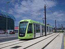
Tramways are managed by Tranvimur. As of 2007, 2 kilometres (1 mile) of line were available. Since 2011, one line is connecting the city center (Plaza Circular) with the University Campus and the Football Stadium.
- By train
Train connections are provided by RENFE. Murcia has a railway station called Murcia del Carmen, located in the neighborhood of the same name. Several long-distance lines link the city with Madrid, through Albacete, as well as Valencia, and Cataluña up to Montpellier in France. Murcia is also the center of a local network. The line C-1 connects the city to Alicante, and the line C-2 connects Murcia to Alcantarilla, Lorca and Águilas. It also has two regional lines connecting it to Cartagena and Valencia.
Healthcare
The hospitals and other public primary healthcare centers belong to the Murcian Healthcare Service. There are three public hospitals in Murcia:
- Ciudad Sanitaria Virgen de La Arrixaca in El Palmar that includes obstetrics and paediatrics units
- Hospital Reina Sofía
- Hospital Morales Meseguer
Education
Murcia has two universities:
- one public university: the University of Murcia, founded in 1272.
- one private university: the Catholic University Saint Anthony, founded in 1996.

There are several high schools, elementary schools, and professional schools. Murcia has three types of schools for children: private schools such as El Limonar International School, Murcia (a British international school) and King's College, Murcia (a British international school), semi-private schools (concertado), which are private schools that receive government funding and sometimes offer religious instruction, and public schools such as Colegio Publico (CP) San Pablo, IES Licenciado Francisco Cascales or the centenary CP Cierva Peñafiel, one of the oldest ones. The French international school, Lycée Français André Malraux de Murcie, is in nearby Molina de Segura.[19]
The private schools and concertados can be religious (Catholic mostly but any religion is acceptable) or secular, but the public schools are strictly secular. Concertado or semi-private or quasi-private schools fill a need by providing schools where the government isn't able to or predate the national school system.
Murcia also offers Adult Education for people who want to return to complete high school and possibly continue on to the university.
Notable people
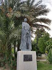
- Muhyī al-Dīn Ibn al-‘Arabī (1165–1240), Islam Sufi master and author,[3] probably the most notable sufi author of history with Al-Ghazali
- Abul Abbas al-Mursi (1219–1286) Islam Sufi master
- Diego de Saavedra Fajardo (1584–1648), writer and diplomat
- Francisco Salzillo (1707–1783), Baroque sculptor
- José Moñino, conde de Floridablanca (1728–1808), statesman, minister of King Charles III of Spain
- Vicente Medina (1866–1937), poet and writer
- Juan de la Cierva (1895–1936), inventor of the autogyro, a forerunner of the helicopter
- Ramón Gaya (1910–2005), painter and writer
- Francisco "Paco" Rabal (1926–2001), actor
- Charo (1951–), musician, actress and entertainer
- Alejandro Valverde (1980–), cyclist
- Nicolás Almagro (1985–), tennis player
- Ruth Lorenzo (1982–), singer
- Xuso Jones (1989–), singer
- Isaac Peral y Caballero (1 June 1851 – 22 May 1895), inventor of the first electric submarine.
Sports teams
- Real Murcia – Spanish Third Division football
- CF Atlético Ciudad – Spanish Third Division (Group 2) football {dissolved in 2010)
- UCAM Murcia – Spanish Second Division football
- CB Murcia – Liga ACB basketball
- ElPozo Murcia Turística FS – futsal
- Hispania Racing F1 Team – Formula One racing
- CAV Murcia 2005 – Superliga Femenina de Voleibol volleyball
- Origen (esports) – League of Legends team
Twin towns—Sister cities
See also
References

Notes
- ↑ Demographia: World Urban Areas - Demographia, 2015
- 1 2 "Historia de Murcia- Edad Media Musulmana - Región de Murcia Digital" (in Spanish). Retrieved 2018-09-12.
- 1 2 "The Meccan Revelations". World Digital Library. 1900–1999. Retrieved 2013-07-14.
- 1 2 "Historia de Murcia - Edad Media Musulmana - Región de Murcia Digital" (in Spanish). Retrieved 2018-09-15.
- ↑ "Historia de Murcia - Edad Media Cristiana - Región de Murcia Digital" (in Spanish). Retrieved 2018-09-15.
- ↑ Pollution of the Segura river (Murcia, Spain)
- ↑ "Pedanías - Portal Ayuntamiento de Murcia" (in Spanish). Retrieved 2018-09-15.
- ↑ "INEbase / Demography and population /Municipal Register. Population by municipalities /Nomenclature: Continuous Register Population by Population Unit / Results". ine.es. Retrieved 2018-09-21.
- ↑ M. Kottek; J. Grieser; C. Beck; B. Rudolf; F. Rubel (2006). "World Map of the Köppen-Geiger climate classification updated". Meteorol. Z. 15: 259–263. doi:10.1127/0941-2948/2006/0130. Retrieved April 22, 2009.
- ↑ "Murcia - Geography And Climate | The English knowledge database". science-train.com. Retrieved 2018-02-21.
- 1 2 "Guía resumida del clima en España (1981–2010)".
- ↑ Boase, Roger (2017). Secrets of Pinar's Game (2 vols): Court Ladies and Courtly Verse in Fifteenth-Century Spain. BRILL. p. 755.
- ↑ "Iglesia Catedral de Santa María-Historia - Región de Murcia Digital" (in Spanish). Retrieved 2018-09-12.
- ↑ "Monumentos y lugares" (in Spanish). Retrieved 2018-09-12.
- ↑ "Museos - Portal Ayuntamiento de Murcia" (in Spanish). Retrieved 2018-09-15.
- ↑ "Murcia - Región de Murcia Digital" (in Spanish). Retrieved 2018-09-22.
- ↑ "Concejalía de Cultura" (in Spanish). Retrieved 2018-09-22.
- ↑ "Murcia Three Cultures International Festival | Murcia, Spain". Whatsonwhen. Archived from the original on 2011-07-22. Retrieved 2011-04-10.
- ↑ "Nous contacter" (in French). Lycée Français André Malraux de Murcie. Archived from the original on 2016-02-27. Retrieved 13 February 2016.
Adresse: Avenida del Golf, 107 Urbanización Altorreal Apartado de correos 133 30506 MOLINA DE SEGURA (Provincia de Murcia) ESPAGNE
- ↑ "Hermanamientos sí, pero con estrategia" (in Spanish). Retrieved 2018-09-22.
- ↑ "Miasta partnerskie Łodzi". Urząd Miasta Łodzi (in Polish). City of Łódź. Archived from the original on 24 June 2013. Retrieved 21 July 2013.
Bibliography
- See also: Bibliography of the history of Murcia
External links
| Wikimedia Commons has media related to Murcia. |
| Wikivoyage has a travel guide for Murcia. |
- Official Tourism Site of Murcia, Spain
- (in Spanish) Ayuntamiento de Murcia (the Town Hall)
Capitals of autonomous communities of Spain | ||
|---|---|---|
1 Autonomous cities | ||