Viti Levu
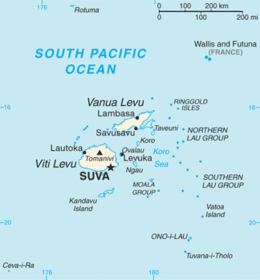 Map of Fiji showing Viti Levu (one of its major islands) | |
 | |
| Geography | |
|---|---|
| Location | Pacific Ocean |
| Coordinates | 17°48′S 178°0′E / 17.800°S 178.000°E |
| Archipelago | Viti Levu Group |
| Area | 10,388 km2 (4,011 sq mi) |
| Area rank | 75th |
| Length | 146 km (90.7 mi) |
| Width | 106 km (65.9 mi) |
| Highest elevation | 1,324 m (4,344 ft) |
| Highest point | Tomanivi |
| Administration | |
|
Fiji | |
| Division | Western Division and Central Division |
| Largest settlement | Suva (pop. 77,366) |
| Demographics | |
| Population | 600,000 |
| Pop. density | 55.83 /km2 (144.6 /sq mi) |
| Ethnic groups |
Native Fijians (54.3%), Indo-Fijians (38.1%); other (Asian, Europeans, other Pacific Islander) (7.6%) |
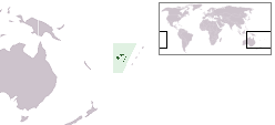
Viti Levu (pronounced [ˈβitʃi ˈleβu]) is the largest island in the Republic of Fiji, the site of the nation's capital, Suva, and home to a large majority of Fiji's population.
Geology
The Fiji lies in a tectonically complex area between the Australian Plate and the Pacific Plate. The Fiji Platform lies in a zone bordered with active extension fault lines around which most of the shallow earthquakes were centered. These fault lines are the Fiji Fracture Zone (FFZ) to the north, the 176° Extension Zone (176°E EZ) to the west, and the Hunter Fracture Zone (HFZ) and Lau Ridge to the east.[1]
The oldest rocks on the island consist of the Eocene to Lower Miocene Wainimala Group. The Lower portion of the Group are composed of volcanic flows and volcanoclastics, which grade from basalt to trachyte and rhyolite. Geographically, this group is found south of Nadi, including the peaks of Koromba (3528’) and Natambumgguto (1242’), down to Sigatoka. From Sigatoka, the Group extends almost all the way to Lodoni, and includes the peaks of Tuvutau (3060’) and Tikituru (3071’), while along the southern coast it extends almost to Nausori. The Group is intruded by the Tholo Plutonics consisting of similar age stocks of tonalite, granodiorite, gabbro and diorite. Mio-Pliocene sandstones and marl, grading into epiclastics and andesitic volcanics of the Suva Group are found mainly in the river valleys such as those formed by the Nadi River and Navua River. The Plio-Pleistocene Mba Grouop is found on the northern portion of the island and consists of porphyritic basalt flows and volcanoclastics grading into greywacke. Geographically it includes the peaks of Koroyanitu (3921’), Malua (3294’), Monavatu (3708’), Mount Tomanivi (4341’), and Ndelamendamu (2540’), and extends along the eastern coast almost to Nausori. It also includes the Emperor Mine near Vatukoula.[2][3]
Geography and economy

Viti Levu is the largest island in the nation, home to 70% of the population (about 600,000), and is the hub of the entire Fijian archipelago.
The island measures 146 kilometres (91 mi) long and 106 kilometres (66 mi) wide, and has an area of 10,389 square kilometres (4,011 sq mi). It is comparable to the size of the Big Island of Hawaiʻi, and slightly smaller than the U.S. state of Connecticut.
Earthquakes and volcanic eruptions account for the somewhat rugged terrain of the island, which is divided into roughly equal halves by a north-south mountain range. The centre of the island is forested and includes the nation's highest peak Mount Tomanivi (otherwise Mount Victoria) rising to 1,324 metres (4,344 ft).
The eastern side of the island experiences heavy rainfall, while the western side is noticeably drier in the range's rain shadow. Accordingly, sugar cane production thrives in the west, while a dairy industry is being built in the east. Fiji's biggest cattle ranch is at Yaqara, with 7000 head of cattle on its 70 square kilometres (17,000 acres), located halfway between Tavua and Rakiraki. The island is the only known home of one of the world's largest insects, the Giant Fijian long-horned beetle.
Localities


Viti Levu hosts the capital city of Suva, and is home to nearly three quarters of the population of the Republic (about 580,000). Other important towns, all around the coast, include Ba, Lautoka, Nadi, Nausori, Rakiraki, and Sigatoka. One major road has been built around the perimeter of Viti Levu. Well-known localities include Natadola Beach, Pacific Harbour (a resort center about 50 kilometers from Suva).
Politics
Eight of Fiji's fourteen Provinces are in Viti Levu. The Provinces of Ba, Nadroga-Navosa, and Ra comprise the Western Division, while Naitasiri, Namosi, Rewa, Serua, and Tailevu form the Central Division. In part because of its high concentration of Indo-Fijians, whose ancestors came mostly as indentured workers from India between 1879 and 1916, the political dynamics of western Viti Levu are somewhat different from those of eastern Viti Levu, where, apart from the multi-racial urban areas, indigenous Fijians are more heavily concentrated.
History
Viti Levu is believed to have been inhabited longer than the northern island of Vanua Levu. According to oral traditions, the first Melanesian settlers landed at Vuda Point and established Viseisei, believed to be Fiji's oldest settlement, although archaeologists refute this claim.
Other
The Canadian entrepreneur Peter Munk named his Klosters house after the island, as Viti Levu was where he and David Gilmour started the Southern Pacific Hotel chain in the 1960s.[4]
References
- ↑ Greenbaum, D.; Bowker, M. R; Dau, I; Drospy, H; Greally, K. B; McDonald A. J. W; Marsh, S. H; Northmore, K. J; O'Connor, E. A; Prasad, R. S & Tragheim, D. G. (1995). "Landslide hazards in Fiji" (PDF). Technical Report WC/95/28 Rapid methods of landslide hazard mapping : Fiji case study. British Geological Survey. Retrieved 23 March 2011.
- ↑ Provisional Geologic Map of Fiji. Suva: Fiji Geological Survey. 1965.
- ↑ Rodda, P. (1967). "Outline of the geology of Viti Levu". New Zealand Journal of Geology and Geophysics. 10 (5): 1260–1273.
- ↑ "Peter Munk: A mining magnate nears the end of his golden reign" ERIC REGULY. The Globe and Mail 15 March 2014
External links

| Wikimedia Commons has media related to Viti Levu. |