Kumamoto
| Kumamoto 熊本市 | |||
|---|---|---|---|
| Designated city | |||
| Kumamoto City | |||
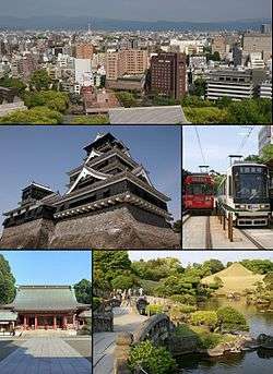 From top left:Central Kumamoto view from Kumamoto Castle, Kumamoto Castle, Kumamoto City Tramway, Fujisaki hachimangu shrine, Suizenji jojuen | |||
| |||
 Location of Kumamoto in Kumamoto Prefecture | |||
 Kumamoto Location in Japan | |||
| Coordinates: 32°47′N 130°44′E / 32.783°N 130.733°ECoordinates: 32°47′N 130°44′E / 32.783°N 130.733°E | |||
| Country | Japan | ||
| Region | Kyushu | ||
| Prefecture | Kumamoto Prefecture | ||
| Government | |||
| • Mayor | Kazufumi Ōnishi[1][2] | ||
| Area | |||
| • Total | 389.53 km2 (150.40 sq mi) | ||
| Population (April 1, 2017) | |||
| • Total | 737,812 | ||
| • Density | 1,900/km2 (4,900/sq mi) | ||
| Symbols | |||
| • Tree | Ginkgo | ||
| • Flower | Camellia | ||
| • Bird | Great tit | ||
| Time zone | UTC+9 (JST) | ||
| City hall address |
1-1 Tetorisai-machi, Chūō-ku, Kumamoto-shi, Kumamoto-ken 860-8601 | ||
| Website |
www | ||


Kumamoto (熊本市 Kumamoto-shi) is the capital city of Kumamoto Prefecture on the island of Kyushu, Japan.
As of April 1, 2017, the city has an estimated population of 737,812[3] and a population density of 1,900 persons per km2. The total area is 389.53 km2.
Greater Kumamoto (熊本都市圏) had a population of 1,461,000, as of the 2000 census. As of 2010, Kumamoto Metropolitan Employment Area has a GDP of US$39.8 billion.[4][5] It is not considered part of the Fukuoka–Kitakyushu metropolitan area, despite their shared border. The city was designated on April 1, 2012 by government ordinance.
History
Katō Kiyomasa, a contemporary of Toyotomi Hideyoshi, was made daimyō of half of the (old) administrative region of Higo in 1588. After that, Kiyomasa built Kumamoto Castle. Due to its many innovative defensive designs, Kumamoto Castle was considered impregnable, and Kiyomasa enjoyed a reputation as one of the finest castle-builders in Japanese history. After Kiyomasa died in 1611, his son, Tadahiro, succeeded him. Tadahiro was removed by Tokugawa Iemitsu in 1632, replacing him with the Hosokawa clan. The current administrative body of the City of Kumamoto was founded on April 1, 1889.
Near the end of World War II, Kumamoto experienced several air raids. The largest one was on the night of June 30 to July 1, 1945. About one third of the city was burned, and more than 300 people died. After the effects of the air raids, the Japanese Buddhist monk Nichidatsu Fujii decided to construct a Peace Pagoda atop Mount Hanaoka in the city to commemorate all those lost in war and to promote peace. Inaugurated in 1954, this pagoda held significance: It inspired Fujii and his followers to build over 80 more around the world including India, Sri Lanka, the United States and the United Kingdom.
On February 1, 1991, the towns of Akita, Kawachi, Tenmei and Hokubu (all from Hōtaku District) were merged into Kumamoto. On October 6, 2008, the town of Tomiai (from Shimomashiki District) was merged into Kumamoto. On March 23, 2010, the town of Jōnan (also from Shimomashiki District) and the town of Ueki (from Kamoto District) were merged into Kumamoto.[6]
A series of earthquakes struck the area beginning April 14, 2016, including a tremor with moment magnitude 7.1 early in the morning of April 16, 2016, local time.[7]
Geography
Climate
Kumamoto has a humid subtropical climate (Köppen climate classification Cfa) with hot summers and cool winters. Precipitation is significant throughout the year, but is much heavier around the summer, especially the months of June and July.
| Climate data for Kumamoto, Kumamoto (1981–2010) | |||||||||||||
|---|---|---|---|---|---|---|---|---|---|---|---|---|---|
| Month | Jan | Feb | Mar | Apr | May | Jun | Jul | Aug | Sep | Oct | Nov | Dec | Year |
| Record high °C (°F) | 22.5 (72.5) |
26.4 (79.5) |
27.4 (81.3) |
30.7 (87.3) |
34.4 (93.9) |
36.1 (97) |
38.8 (101.8) |
38.5 (101.3) |
37.0 (98.6) |
33.7 (92.7) |
28.9 (84) |
24.6 (76.3) |
38.8 (101.8) |
| Average high °C (°F) | 10.5 (50.9) |
12.1 (53.8) |
15.7 (60.3) |
21.3 (70.3) |
25.6 (78.1) |
28.2 (82.8) |
31.7 (89.1) |
33.2 (91.8) |
29.9 (85.8) |
24.6 (76.3) |
18.5 (65.3) |
13.0 (55.4) |
22.0 (71.6) |
| Daily mean °C (°F) | 5.7 (42.3) |
7.1 (44.8) |
10.6 (51.1) |
15.7 (60.3) |
20.2 (68.4) |
23.6 (74.5) |
27.3 (81.1) |
28.2 (82.8) |
24.9 (76.8) |
19.1 (66.4) |
13.1 (55.6) |
7.8 (46) |
16.9 (62.4) |
| Average low °C (°F) | 1.2 (34.2) |
2.3 (36.1) |
5.6 (42.1) |
10.3 (50.5) |
15.2 (59.4) |
19.8 (67.6) |
24.0 (75.2) |
24.4 (75.9) |
20.8 (69.4) |
14.2 (57.6) |
8.3 (46.9) |
3.1 (37.6) |
12.5 (54.5) |
| Record low °C (°F) | −9.2 (15.4) |
−9.2 (15.4) |
−6.9 (19.6) |
−2.5 (27.5) |
1.3 (34.3) |
7.1 (44.8) |
14.3 (57.7) |
15.3 (59.5) |
6.7 (44.1) |
0.5 (32.9) |
−3.8 (25.2) |
−7.9 (17.8) |
−9.2 (15.4) |
| Average rainfall mm (inches) | 60.1 (2.366) |
83.3 (3.28) |
137.9 (5.429) |
145.9 (5.744) |
195.5 (7.697) |
404.9 (15.941) |
400.8 (15.78) |
173.5 (6.831) |
170.4 (6.709) |
79.4 (3.126) |
80.6 (3.173) |
53.6 (2.11) |
1,985.9 (78.186) |
| Average rainy days (≥ 0.5 mm) | 8.6 | 9.0 | 12.4 | 10.9 | 11.1 | 14.4 | 13.5 | 10.7 | 10.6 | 6.9 | 7.9 | 8.2 | 124.2 |
| Average relative humidity (%) | 70 | 67 | 67 | 66 | 68 | 75 | 77 | 73 | 72 | 69 | 72 | 71 | 71 |
| Mean monthly sunshine hours | 132.6 | 139.5 | 158.5 | 181.4 | 187.2 | 141.0 | 184.5 | 211.0 | 175.9 | 189.7 | 153.0 | 147.5 | 2,001.8 |
| Source #1: Japan Meteorological Agency[8] | |||||||||||||
| Source #2: Japan Meteorological Agency (records)[9] | |||||||||||||
Landmarks

The city's most famous landmark is Kumamoto Castle, a large and, in its day, extremely well fortified Japanese castle. The donjon (castle central keep) is a concrete reconstruction built in the 1970s, but several ancillary wooden buildings remain of the original castle, which was assaulted during the Satsuma Rebellion and sacked and burned after a 53-day siege. It was during this time that the tradition of eating basashi (raw horse meat) originated. Basashi remains popular in Kumamoto and, to a lesser extent, elsewhere in Japan, though these days it is usually considered a delicacy.
Within the outer walls of Kumamoto Castle is the Hosokawa Gyobu-tei, the former residence of the Higo daimyō. This traditional wooden mansion has a fine Japanese garden located on its grounds.
Miyamoto Musashi lived the last part of his life in Kumamoto. His tomb and the cave where he resided during his final years (known as Reigandō, or "spirit rock cave") is situated close by. He penned the famous Go Rin no Sho (The Book of Five Rings) whilst living here.
Kumamoto is also home to Suizen-ji Jōju-en, a formal garden neighboring Suizenji Temple approximately 3 kilometers southeast of Kumamoto Castle.
A notable shrines are Takahashi Inari Shrine, Fujisaki Hachimangū.
Suizenji Park is also home to the Suizenji Municipal Stadium, where the city's football team, Roasso Kumamoto used to play regularly, but nowadays they use the larger KKWing Stadium in Higashi Ward.
The downtown area has a commercial district centred on two shopping arcades, the Shimotori and Kamitori, which extend for several city blocks. The main department stores are located here along with a vast number of smaller retailers, restaurants, and bars. Many local festivals are held in or near the arcades.
Cultural venues include the Kumamoto Prefectural Museum of Art and Kumamoto Prefectural Theater.
Kumamoto has a prefectural mascot, "Kumamon". Kumamon is a black bear with red cheeks.[10]
Government
Kazufumi Ōnishi has been the city's mayor since December 2014.[11]
Wards
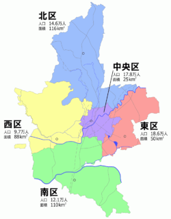
Since April 1, 2012, Kumamoto has five wards (ku):
- Kita-ku (北区)
- Nishi-ku (西区)
- Chūō-ku (中央区)
(administrative center) - Higashi-ku (東区)
- Minami-ku (南区)
Working mother incident
In November 2017, Kumamoto politician Yuka Ogata was forced to leave the Kumamoto municipal assembly because she had brought her baby.[12] The incident was reported by international media as an example of the challenges facing women in Japan.[13]
Transport

Local public transport is provided by the Kumamoto City Transportation Bureau. Trams run to a few suburbs near the downtown area. A large bus terminus, called the Kotsu Centre, provides access to both local and intercity destinations. JR Kumamoto station provides rail links to Japan's extensive rail network. On March 12, 2011, work on the shinkansen (high-speed bullet train) network was completed, establishing a direct high-speed rail link to Tokyo via Fukuoka's Hakata station. Several local taxi companies serve the Kumamoto metropolitan area and are the only 24-hour public transport in the city.
Kumamoto Airport is located in nearby Mashiki.
Sports
There is a local football club Roasso Kumamoto in J.League. Kumamoto Volters of the basketball B.League are based in Kumamoto.
Sporting events
The Kumamoto Castle Marathon is a yearly event in Kumamoto City. It was established in commemoration of Kumamoto becoming a designated city in 2012.[14] The 1997 World Men's Handball Championship was also played in town.
Education
Notable people
- Naochi Fujimori, father of former Peruvian president Alberto Fujimori
- Inoue Kowashi, statesman
- Sayuri Ishikawa, enka singer
- Masahiko Kimura, judoka
- Rie Kugimiya, voice actress
- Yuri Masuda, vocalist from the group m.o.v.e
- Higonoumi Naoya, sumo wrestler
- Eiichiro Oda, manga artist, author of One Piece
- Momoko Ueda, professional golfer
- Yōko Shimada, actress
- Yokoi Shōnan, scholar and political reformer
- Kaji Yajima, educator, pacifist, president of the WCTU in Japan
- Isao Yukisada, film director
- Yuta Iwasada, Japanese baseball player
Sister cities
Kumamoto City is twinned with the following cities.


References
- ↑ "Kumamoto City". JAPAN SHOWCASE. The Japan Times. Retrieved 24 October 2015.
- ↑ "市長名の検索結果" (in Japanese). 全国市長会 (Japan Association of City Mayors). Retrieved 24 October 2015.
- ↑ "Official website of Kumamoto City" (in Japanese). Japan: Kumamoto City. Retrieved 29 April 2017.
- ↑ Yoshitsugu Kanemoto. "Metropolitan Employment Area (MEA) Data". Center for Spatial Information Science, The University of Tokyo.
- ↑ Conversion rates - Exchange rates - OECD Data
- ↑ "都道府県別市町村変更情報:福岡 Archived 2010-04-06 at the Wayback Machine.." kokudo.or.jp. Retrieved on November 22, 2008. (in Japanese)
- ↑ "Japan earthquake: Powerful new tremor in Kumamoto". BBC News. 2016-04-15. Retrieved 2016-04-15.
- ↑ "平年値(年・月ごとの値)". Japan Meteorological Agency. Retrieved 2011-12-02.
- ↑ "観測史上1~10位の値(年間を通じての値)". Japan Meteorological Agency. Retrieved 2011-12-02.
- ↑ The Life and Times of Japan’s Mascots
- ↑ "市長のプロフィール" (in Japanese). 熊本市 (Kumamoto City). 3 December 2014. Retrieved 24 October 2015.
- ↑ https://www.theguardian.com/world/2017/nov/24/japanese-politicians-force-colleague-baby-leave-chamber-women
- ↑ https://www.washingtonpost.com/world/a-japanese-politician-took-her-baby-to-work-the-patriarchy-was-not-impressed/2017/11/24/e5bb695c-d0fc-11e7-8447-3d80b84bebad_story.html
- ↑ Kumamoto Castle Marathon website Information on 2013 Kumamoto Castle Marathon Archived 2012-11-01 at the Wayback Machine.
- ↑ "Twinning". City of Heidelberg. Archived from the original on 2011-06-10. Retrieved 2009-11-12.
- ↑ City of San Antonio International Relations Office. Retrieved 12 October 2011
- ↑
External links
| Wikimedia Commons has media related to Kumamoto. |
- Kumamoto City official website (in Japanese)
- Kumamoto City official website (in English)


| Wards of Kumamoto | ||
|---|---|---|
| Cities | ||
| Districts | ||