U.S. Route 19
U.S. Route 19 (US 19) is a north–south U.S. Highway in the Eastern United States. Despite encroaching Interstate Highways, the route has remained a long-haul route, connecting the Gulf of Mexico with Lake Erie.
| ||||
|---|---|---|---|---|
 | ||||
| Route information | ||||
| Length | 1,438 mi (2,315 km) | |||
| Existed | 1926–present | |||
| Major junctions | ||||
| South end | ||||
| ||||
| North end | ||||
| Location | ||||
| States | Florida, Georgia, North Carolina, Tennessee, Virginia, West Virginia, Pennsylvania | |||
| Highway system | ||||
| ||||

The highway's southern terminus is at Memphis, Florida, which is just south of St. Petersburg at an intersection with U.S. Route 41. Its northern terminus is in Erie, Pennsylvania, at an intersection with U.S. Route 20 about two miles (3 km) from the shores of Lake Erie.[1]
The length of the highway is 1,438 miles (2,314 km), including both U.S. Route 19E/U.S. Route 19W paths through North Carolina and Tennessee.[2][3][4][5][6][7][8][9][10]
Route description
| mi | km | |
|---|---|---|
| FL[2] | 262.0 | 421.6 |
| GA[3] | 348.0 | 560.1 |
| NC[4] | 145.0 | 233.4 |
| 19E[5] | 75.9 | 122.1 |
| 19W[6] | 62.6 | 100.7 |
| TN[7] | 11.8 | 19.0 |
| VA[8] | 88.9 | 143.0 |
| WV[9] | 249.0 | 400.7 |
| PA[10] | 195.0 | 313.8 |
| Total | 1,438.2 | 2,314.6 |
Florida
.svg.png)
US 19 runs 264 miles (425 km) along Florida's west coast from an interchange with US 41 in Memphis, south of St. Petersburg, and continues to the Georgia border north of Monticello. US 19 remains independent of I-75, even as the routes converge in the Tampa Bay Area. The route is co-signed with I-275 over the Sunshine Skyway Bridge, a cable-stayed bridge over the mouth of Tampa Bay, US 98 between Chassahowitzka and Perry, US 27 Alt. between Chiefland and Perry, and US 27 between and Perry and Capps.
The "secret" designation for US 19 in Florida, between Memphis and Perry, is SR 55. Between Perry and Capps, it follows SR 20, and between Capps and the Georgia border, it follows SR 57.
According to a Dateline NBC study, part of US 19 in Florida is the most dangerous road in the United States. A Highway Patrol test period beginning in 1998 and ending in 2003, as mandated by the National Highway Traffic Safety Administration, showed the stretch of US 19 from Pasco County to Pinellas County to average approximately 52 deaths a year, or 262 deaths in the five-year duration of the study; 100 of these deaths were pedestrian related, making US 19 the worst road to walk on in these two counties.[11] Multiple efforts to improve US 19 have been suggested to the FDOT, among them, an overpass strictly for left-turn lanes.[12]
Currently, US 19 between Clearwater and St. Petersburg is getting a freeway-style upgrade due to the cancellation of an extension of Interstate 375 in the late 1970s.[13][14]
Georgia
US 19 enters Georgia just south of Thomasville, concurrent with SR 3. It continues north, passing through Albany, Americus, Ellaville, Butler, Thomaston, and Zebulon. It becomes concurrent with US 41 in Griffin. It then proceeds through the western tip of Henry County, passing through Hampton, home of the Atlanta Motor Speedway, and continues north through Clayton County and Jonesboro, entering Atlanta.
US 19/US 41 travels through the south side of Atlanta as Metropolitan Parkway (formerly Stewart Avenue) and through Downtown Atlanta as Northside Drive. The concurrencies with US 41 and SR 3 end when US 19 turns east onto 14th Street in Midtown, beginning a concurrency with SR 9. It then turns north on Peachtree Street until it intersects with SR 141 in Buckhead and becomes Roswell Road. US 19 then continues north through Sandy Springs until it reaches I-285's north side. There, the concurrency with SR 9 ends and US 19 is briefly concurrent with I-285, for about 1.5 miles (2.4 km).
US 19 leaves I-285 to travel through the northern suburbs of Atlanta along SR 400. Most of this section is a limited-access road with four lanes in each direction, becoming two lanes in each direction as the highway continues away from the northern suburbs of Atlanta. It arrives in Dahlonega, where it is no longer concurrent with SR 400, before about 37 miles (60 km) of extremely curvy road, which includes a concurrency with US 129. The last major town it travels through in Georgia is Blairsville.
North Carolina

US 19 is co-signed with US 129 from the Georgia line to Murphy, then is co-signed with US 74, as well as US 129 as far as Graham County. US 19 and US 74 are co-signed as far as Ela, after which US 74 veers south, leaving US 19 to head into the Great Smoky Mountains. US 19 passes through the Eastern Cherokee Indian Reservation. For a brief time, US 19 is co-signed with US 276. Then US 19 is co-signed with US 23 from Lake Junaluska to Mars Hill (and with US 70 in Asheville), which closely parallels I-40 and then Future I-26.
Just north of Mars Hill, US 19 continues solo to Cane River, where US 19 splits: US 19E towards Burnsville and US 19W towards Erwin, Tennessee.
U.S. Route 19E
Traversing 75.9 miles (122.1 km) from Cane River, North Carolina to Bluff City, Tennessee, US 19E first goes east to Burnsville and Spruce Pine, then north along the banks of the North Toe River to Cranberry and Elk Park, before crossing the North Carolina/Tennessee state line. Heading northeast, it goes through Roan Mountain, Hampton and Elizabethton, rendezvousing with US 19W in Bluff City.
U.S. Route 19W

Traversing 62.6 miles (100.7 km) from Cane River, North Carolina to Bluff City, Tennessee, US 19W goes immediately north along the banks of the Cane River to the communities of Ramseytown and Sioux, then northwest through the Unaka Range, crossing the North Carolina/Tennessee state line. At Ernestville, US 19W joins with I-26/US 23 and proceeds through Erwin, Unicoi and Johnson City. In Johnson City, it switches partners to US 11E along Bristol Highway, rendezvousing with US 19E in Bluff City.
Tennessee
US 19 starts again in Bluff City, heading northeast along the Volunteer Parkway (and concurrency with US 11E) to Bristol. In downtown Bristol, US 19 crosses the Tennessee/Virginia state line on State Street.
Virginia
US 19 goes northeast from Bristol, parallel to I-81, until Abingdon. It then heads north to Lebanon, through the Clinch Mountains, then northeast again through the towns of Claypool Hill, Tazewell, and then finally to Bluefield, where it enters West Virginia.
West Virginia
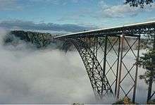
_in_Lewis_County%2C_West_Virginia.jpg)

US 19 enters West Virginia as a four-lane highway in Bluefield, where it narrows to two lanes as it winds northward. It later parallels I-77/I-64 until it reaches Beckley, where it goes northeasterly on an expressway-grade four-lane highway. Crossing the New River via the New River Gorge Bridge near Fayetteville, it passes through Summersville and Birch River before arriving at I-79, 5-mile (8.0 km) south of Sutton. From there, it runs concurrent with I-79 from exit 57 to exit 67 at Flatwoods. Then, it exits and reverts to a two-lane highway, more or less following the route of I-79 as it passes through Weston, Clarksburg, Fairmont, and Morgantown before crossing into Pennsylvania. The distance from Beckley from I-79 is also known as ADHS Corridor L. It allows traffic to the Pittsburgh area to bypass Charleston, and is thus part of a main link from Charlotte and Myrtle Beach to Pittsburgh.
US 19 through Summersville, West Virginia has been dubbed the "world's largest speed trap".[15]
Pennsylvania
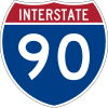
US 19 is closely paralleled by I-79 for its entire length. From the state line, it goes north to Washington and then through Pittsburgh. In downtown Pittsburgh, US 19 crosses the Ohio River via West End Bridge. In Cranberry Township, north of Pittsburgh, US 19 shares a major junction between I-76 (Pennsylvania Turnpike) and I-79, via the Cranberry Connector. US 19 crosses I-80 in the East Lackawannock Township. Near Erie, it crosses I-90 before going through the downtown area, ending at US 20 (26th Street).
ADHS corridors
US 19 overlaps with three corridors that are part of the Appalachian Development Highway System (ADHS), which is part of Appalachian Regional Commission (ARC). Passed in 1965, the purpose of ADHS is to generate economic development in previously isolated areas, supplement the interstate system, connect Appalachia to the interstate system, and provide access to areas within the Region as well as to markets in the rest of the nation.[16]
- Corridor A – From I-285, in Sandy Springs, Georgia, to I-40, near Clyde, North Carolina. US 19/SR 400 overlaps from Sandy Springs to SR 141, near Cumming in Georgia. The entire section is a controlled-access highway.[17]
- Corridor A-1 – From SR 141, near Cumming, Georgia, to SR 53, near Dawsonville, Georgia. The entire 15.8-mile (25.4 km) section of US 19/SR 400 is authorized for ADHS funding. The entire route is a divided four-lane highway, with the southern section a controlled-access highway and the northern section being a limited-access road.[17]
- Corridor K – From I-75, in Cleveland, Tennessee, to US 23, in Dillsboro, North Carolina. US 19 overlaps from US 64/US 74, near Murphy, to US 74 (Great Smoky Mountains Expressway), near Bryson City. The routing is a four-lane limited-access road from near Murphy to Andrews; the rest is two-lane through the Nantahala Gorge. Future plans include building a new four-lane limited-access road from Andrews, through Robbinsville, to Stecoah, bypassing the Nantahala Gorge.[18]
- Corridor L – From I-64/I-77, near Beckley, West Virginia, to I-79, near Sutton, West Virginia. Of the 69.9-mile (112.5 km) section of US 19, only 60.5-mile (97.4 km) was authorized for ADHS funding. This corridor is considered complete, with a divided four-lane limited-access road with interchanges at major intersections.[19]
- Corridor Q – From US 23/US 119, in Shelbiana, Kentucky, to I-81, near Christiansburg, Virginia. US 19 overlaps from US 460, in Claypool Hill, Virginia, to US 460, in Princeton, West Virginia. The entire route is a mostly divided four lane limited-access road with interchanges at major intersections.[19][20]
History
Florida
US 19 first entered Florida in 1929. It underwent two route shifts, the first in 1933 and the second in 1946, which adjusted it to its current alignment. US 19 was extended to its southern terminus of Memphis in September 1954, when the original Sunshine Skyway Bridge opened to traffic.
Starting around 1956 US19 was 4-laned, initially in the Perry area, working north toward the Georgia border. The entire route in Florida was 4-laned by 1972.
The planned St. Petersburg–Clearwater Expressway, or Pinellas Beltway, would have followed the current alignment of "Alt 19" from I-275 to Clearwater, Florida. The intersection of Seminole Boulevard and Bay Pines Boulevard is a remnant of this proposed road. The beltway road was proposed in 1974, but it was dead by 1980.[21]
Georgia
North Carolina
In North Carolina, US 19 was NC 10 from the Georgia state line to Asheville, NC 29 from Asheville to Madison County, NC 69 to a point near the Tennessee state line, and either NC 194 or NC 694 for a short distance south of the Tennessee state line.
The original US 19 in Yancey, Mitchell, and Avery Counties mostly followed the route now designated US 19E. US 19W in Yancey County was US 19-23 in 1935, and what is now US 19E was US 19A. The US 19E and US 19W designations have been used since 1930.
Prior to 1948, US 19 between Ela and Waynesville essentially followed the route of present-day US 74. Then, this road was called US 19 Alternate (US 19-A) and the section of NC 28 From Ela to Cherokee and the section of NC 293 from Cherokee to near Waynesville became US 19. Improvements were made, including a new section of highway west of Lake Junaluska.
Around 1956, US 19-23 was widened to four lanes from Lake Junaluska to Canton.
By 1970, a section of US 19 west of Murphy, also designated US 64 (and later US 74), was widened to four lanes.[22]
In January 1983, after improvements to US 19-A had made it similar to an Interstate Highway, the state proposed designating US 19-A as US 19 Bypass. At one point, changing US 19-A to US 19 was considered, but businesses in Maggie Valley opposed the idea of their highway being changed to US 19-A. US 19-A became the Great Smoky Mountains Expressway.[23]
Tennessee
Virginia
West Virginia
Prior to the United States Numbered Highway System, US 19 was West Virginia Route 4.
Pennsylvania
Major intersections
- Southern segment
- Florida


- Georgia


- North Carolina


.svg.png)


- Northern segment
- Tennessee


- Virginia


- West Virginia


- Pennsylvania


See also

- Special routes of U.S. Route 19
- U.S. Route 119
- U.S. Route 219
- U.S. Route 319
References
- "Endpoints of US highways". Archived from the original on October 6, 2014. Retrieved October 6, 2014.
- Google (January 30, 2011). "US 19 in Florida" (Map). Google Maps. Google. Retrieved January 30, 2011.
- Google (January 30, 2011). "US 19 in Georgia" (Map). Google Maps. Google. Retrieved January 30, 2011.
- Google (July 2, 2014). "US 19 in North Carolina" (Map). Google Maps. Google. Retrieved July 2, 2014.
- Google (August 26, 2011). "U.S. Route 19E" (Map). Google Maps. Google. Retrieved August 26, 2011.
- Google (January 30, 2011). "U.S. Route 19W" (Map). Google Maps. Google. Retrieved January 30, 2011.
- Google (July 2, 2014). "US 19 in Tennessee" (Map). Google Maps. Google. Retrieved July 2, 2014.
- Google (January 30, 2011). "US 19 in Virginia" (Map). Google Maps. Google. Retrieved January 30, 2011.
- Google (January 30, 2011). "US 19 in West Virginia" (Map). Google Maps. Google. Retrieved January 30, 2011.
- Google (October 13, 2008). "US 19 in Pennsylvania" (Map). Google Maps. Google. Retrieved October 13, 2008.
- "MSNBC report on America's deadliest roads". NBC News. June 7, 2005. Retrieved April 21, 2007.
- Suncoast News Taking the High Road by Carl Orth; August 4, 2001
- "Florida @ SouthEastRoads - U.S. Highway 19". Southeastroads.com. July 5, 2008. Retrieved August 15, 2012.
- "U.S. 19 - Improvements for the Future". Myus19.com. Retrieved August 15, 2012.
- Anya Sostek (November 20, 2005). "Speed trap or safety measure? Summersville, W. Va., police wrote 10,000 tickets in 2004". Pittsburgh Post-Gazette. Retrieved January 10, 2008.
- "Appalachian Development Highway System". Appalachian Regional Commission. Retrieved June 30, 2014.
- "Status of Corridors in Georgia" (PDF). Appalachian Regional Commission. September 30, 2013. Retrieved July 3, 2014.
- "Status of Corridors in North Carolina" (PDF). Appalachian Regional Commission. September 30, 2013. Retrieved July 3, 2014.
- "Status of Corridors in West Virginia" (PDF). Appalachian Regional Commission. September 30, 2013. Retrieved July 3, 2014.
- "Status of Corridors in Virginia" (PDF). Appalachian Regional Commission. September 30, 2013. Retrieved July 3, 2014.
- "Pinellas Beltway/St. Petersburg Clearwater Expressway reference". Retrieved October 6, 2014.
- "NCRoads.com: U.S. 19". Retrieved November 19, 2009.
- Doris Burrell, "Expressway: State Makes It Official," The Mountaineer, January 20, 1984.
External links

- Endpoints of US highway 19
Routes in italics are no longer a part of the system. Highlighted routes are considered main routes of the system. |