Dane County, Wisconsin
| Dane County, Wisconsin | ||
|---|---|---|
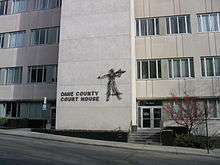 The Dane County Courthouse, 2004 | ||
| ||
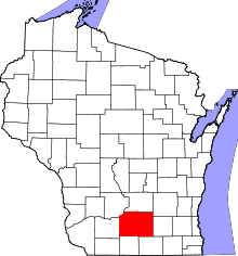 Location in the U.S. state of Wisconsin | ||
 Wisconsin's location in the U.S. | ||
| Founded | 1839 | |
| Named for | Nathan Dane | |
| Seat | Madison | |
| Largest city | Madison | |
| Area | ||
| • Total | 1,238 sq mi (3,206 km2) | |
| • Land | 1,197 sq mi (3,100 km2) | |
| • Water | 41 sq mi (106 km2), 3.3% | |
| Population (est.) | ||
| • (2017) | 536,416[1] | |
| • Density | 431/sq mi (166/km2) | |
| Congressional district | 2nd | |
| Time zone | Central: UTC−6/−5 | |
| Website |
www | |

Dane County is a county in the U.S. state of Wisconsin. As of the 2010 census, the population was 488,075, making it the second-most populous county in Wisconsin. The 2017 estimate places the county's population at 536,416.[1] The county seat is Madison,[2] which is also the state capital.
Dane County is part of the Madison, Wisconsin, Metropolitan Statistical Area, as well as the Madison-Janesville-Beloit Combined Statistical Area.
History
Dane County was formed in 1836 as a territorial county and organized in 1839.[3] It was named after Nathan Dane, a Massachusetts delegate to the Congress of the Confederation who helped carve Wisconsin out of the Northwest Territory.[4][5] Dane County was settled in the 1840s by settlers from New England.[6]
Geography
According to the U.S. Census Bureau, the county has an area of 1,238 square miles (3,210 km2), of which 1,197 square miles (3,100 km2) is land and 41 square miles (110 km2) (3.3%) is water.[7]
Major highways


Airports
- Dane County Regional Airport (MSN) provides commercial airline service.
- Middleton Municipal Airport (C29) serves the county and surrounding communities.
Adjacent counties
- Columbia County (north)
- Dodge County (northeast)
- Green County (south)
- Iowa County (west)
- Jefferson County (east)
- Rock County (southeast)
- Sauk County (northwest)
Demographics
| Historical population | |||
|---|---|---|---|
| Census | Pop. | %± | |
| 1840 | 314 | — | |
| 1850 | 16,639 | 5,199.0% | |
| 1860 | 43,922 | 164.0% | |
| 1870 | 53,096 | 20.9% | |
| 1880 | 53,233 | 0.3% | |
| 1890 | 59,578 | 11.9% | |
| 1900 | 69,435 | 16.5% | |
| 1910 | 77,435 | 11.5% | |
| 1920 | 89,432 | 15.5% | |
| 1930 | 112,737 | 26.1% | |
| 1940 | 130,660 | 15.9% | |
| 1950 | 169,357 | 29.6% | |
| 1960 | 222,095 | 31.1% | |
| 1970 | 290,272 | 30.7% | |
| 1980 | 323,545 | 11.5% | |
| 1990 | 367,085 | 13.5% | |
| 2000 | 426,526 | 16.2% | |
| 2010 | 488,073 | 14.4% | |
| Est. 2017 | 536,416 | [8] | 9.9% |
| U.S. Decennial Census[9] 1790–1960[10] 1900–1990[11] 1990–2000[12] 2010–2014[1] | |||
2010 census
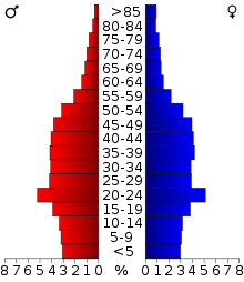
As of the census[13] of 2010, there were 488,073 people, 203,750 households, and 116,752 families residing in the county. The population density was 394 people per square mile (152/km²). There were 216,022 housing units at an average density of 174 per square mile (67/km²). The racial makeup of the county was 84.7% White, 5.2% Black or African American, 0.4% Native American, 4.7% Asian, 0.003% Pacific Islander, 2.5% from other races, and 2.5% from two or more races. 5.9% of the population were Hispanic or Latino of any race.
There were 203,750 households out of which 27.0% had children under the age of 18 living with them, 45.1% were married couples living together, 8.6% had a female householder with no husband present, and 42.7% were non-families. 30.5% of all households were made up of individuals and 7.7% had someone living alone who was 65 years of age or older. The average household size was 2.33 and the average family size was 2.95.
In the county, the population was spread out with 21.7% under the age of 18, 12.8% from 18 to 24, 29.5% from 25 to 44, 25.7% from 45 to 64, and 10.3% who were 65 years of age or older. The median age was 34.4 years. For every 100 females, there were 97.80 males. For every 100 females age 18 and over, there were 96.00 males.
2000 census
As of the census[13] of 2000, there were 426,526 people, 173,484 households, and 100,794 families residing in the county. The population density was 355 people per square mile (137/km²). There were 180,398 housing units at an average density of 150 per square mile (58/km²). The racial makeup of the county was 88.96% White, 4.00% Black or African American, 0.33% Native American, 3.45% Asian, 0.03% Pacific Islander, 1.43% from other races, and 1.79% from two or more races. 3.37% of the population were Hispanic or Latino of any race. 34.4% were of German, 11.5% Norwegian, 8.9% Irish and 6.0% English ancestry.
There were 173,484 households out of which 29.00% had children under the age of 18 living with them, 47.10% were married couples living together, 7.90% had a female householder with no husband present, and 41.90% were non-families. 29.40% of all households were made up of individuals and 7.00% had someone living alone who was 65 years of age or older. The average household size was 2.37 and the average family size was 2.97.
In the county, the population was spread out with 22.60% under the age of 18, 14.30% from 18 to 24, 32.50% from 25 to 44, 21.30% from 45 to 64, and 9.30% who were 65 years of age or older. The median age was 33 years. For every 100 females, there were 97.90 males. For every 100 females age 18 and over, there were 96.00 males.
Government
.jpg)
Dane County is governed by a county executive and a County Board of Supervisors. The county executive is elected in a countywide vote. The County Executive is Joe Parisi. The Board of Supervisors consists of 37 members, each elected from single member districts. As the policy-making body of the county government, the Board of Supervisors enacts county ordinances, levies taxes, and appropriates money for services.
Politics
Dane County has supported the Democratic nominee for president all but five times since 1912, and in every election since 1960.
| Year | Republican | Democratic | Third parties |
|---|---|---|---|
| 2016 | 23.0% 71,275 | 71.4% 217,697 | 6.6% 20,382 |
| 2012 | 27.5% 83,644 | 71.0% 216,071 | 1.5% 4,466 |
| 2008 | 25.8% 73,065 | 72.8% 205,984 | 1.4% 3,890 |
| 2004 | 33.0% 90,369 | 66.0% 181,052 | 1.0% 2,828 |
| 2000 | 32.6% 75,790 | 61.2% 142,317 | 6.3% 14,632 |
| 1996 | 30.9% 59,487 | 56.9% 109,347 | 12.2% 23,468 |
| 1992 | 29.5% 61,957 | 54.6% 114,724 | 15.9% 33,441 |
| 1988 | 39.3% 69,143 | 59.9% 105,414 | 0.8% 1,377 |
| 1984 | 43.8% 74,823 | 55.5% 94,659 | 0.7% 1,203 |
| 1980 | 34.2% 57,545 | 50.8% 85,609 | 15.0% 25,251 |
| 1976 | 41.6% 63,466 | 54.0% 82,321 | 4.4% 6,765 |
| 1972 | 40.9% 56,020 | 58.1% 79,567 | 1.1% 1,439 |
| 1968 | 38.4% 39,917 | 57.6% 59,951 | 4.0% 4,193 |
| 1964 | 28.4% 27,124 | 71.4% 68,118 | 0.2% 184 |
| 1960 | 47.8% 43,245 | 52.0% 47,045 | 0.2% 212 |
| 1956 | 51.1% 38,955 | 48.4% 36,891 | 0.5% 367 |
| 1952 | 50.3% 38,724 | 49.4% 37,987 | 0.3% 216 |
| 1948 | 37.8% 22,934 | 58.5% 35,486 | 3.7% 2,244 |
| 1944 | 38.0% 23,021 | 61.1% 37,076 | 0.9% 554 |
| 1940 | 34.8% 21,845 | 64.2% 40,331 | 1.0% 611 |
| 1936 | 28.8% 15,233 | 67.8% 35,856 | 3.4% 1,819 |
| 1932 | 39.9% 19,083 | 56.1% 26,841 | 4.0% 1,899 |
| 1928 | 54.9% 23,680 | 44.3% 19,126 | 0.8% 364 |
| 1924 | 31.3% 12,280 | 5.3% 2,081 | 63.4% 24,847 |
| 1920 | 77.5% 22,842 | 16.6% 4,879 | 6.0% 1,767 |
| 1916 | 40.1% 6,931 | 57.1% 9,859 | 2.8% 483 |
| 1912 | 32.3% 5,244 | 55.5% 9,017 | 12.2% 1,989 |
| 1908 | 52.4% 9,441 | 43.4% 7,818 | 4.2% 750 |
| 1904 | 63.5% 11,041 | 32.7% 5,679 | 3.8% 666 |
| 1900 | 58.4% 9,396 | 38.1% 6,129 | 3.5% 562 |
| 1896 | 56.1% 9,080 | 40.3% 6,521 | 3.6% 585 |
| 1892 | 44.9% 6,445 | 47.6% 6,833 | 7.4% 1,068 |
County executives
- George Reinke, 1973-1981
- Jonathan B. Barry, 1981-1988
- Richard J. Phelps, 1988-1997
- Kathleen Falk, 1997-2011
- Joe Parisi, 2011–present
Recreation
County parks
- Babcock County Park
- Badger Prairie County Park
- Blooming Grove Drumlins
- Blue Mounds Natural Resource Area
- Brigham County Park
- CamRock County Park
- Cherokee Marsh
- Donald County Park
- Festge County Park
- Fish Camp County Park
- Fish Lake County Park
- Goodland County Park
- Halfway Prairie School
- Indian Lake County Park
- Jenni & Kyle Preserve
- La Follette County Park
- Lake Farm County Park
- Lake View Hill Park
- Lussier County Park
- McCarthy County Park
- Mendota County Park
- Phil's Woods County Park
- Prairie Moraine County Park
- Riley-Deppe County Park
- Salmo Pond County Park
- Scheidegger Forest
- Schumacher Farm
- Stewart Lake County Park
- Token Creek County Park
- Viking County Park
- Walking Iron County Park
- Yahara Heights County Park
Communities
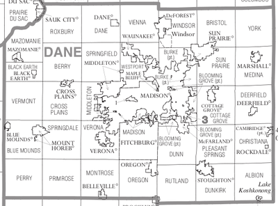
Cities
- Edgerton (mostly in Rock County)
- Fitchburg
- Madison (county seat)
- Middleton
- Monona
- Stoughton
- Sun Prairie
- Verona
Villages
- Belleville (partly in Green County)
- Black Earth
- Blue Mounds
- Brooklyn (partly in Green County)
- Cambridge (partly in Jefferson County)
- Cottage Grove
- Cross Plains
- Dane
- Deerfield
- DeForest
- Maple Bluff
- Marshall
- Mazomanie
- McFarland
- Mount Horeb
- Oregon
- Rockdale
- Shorewood Hills
- Waunakee
- Windsor
Towns
- Albion
- Berry
- Black Earth
- Blooming Grove
- Blue Mounds
- Bristol
- Burke
- Christiana
- Cottage Grove
- Cross Plains
- Dane
- Deerfield
- Dunkirk
- Dunn
- Madison
- Mazomanie
- Medina
- Middleton
- Montrose
- Oregon
- Perry
- Pleasant Springs
- Primrose
- Roxbury
- Rutland
- Springdale
- Springfield
- Sun Prairie
- Vermont
- Verona
- Vienna
- Westport
- York
Unincorporated communities
- Albion
- Aldens Corners
- Ashton
- Ashton Corners
- Bakers Corners
- Basco
- Burke
- Daleyville
- Deansville
- Door Creek
- Dunkirk
- East Bristol
- Elvers
- Five Points
- Forward
- Hanerville
- Highwood
- Hillside
- Hoffman Corners
- Hope
- Indian Heights
- Kegonsa
- Kingsley Corners
- Klevenville
- London (partial)
- Lutheran Hill
- Martinsville
- Marxville
- Middleton Junction
- Montrose
- Morrisonville
- Mt. Vernon
- Nora
- North Bristol
- Norway Grove
- Old Deerfield
- Paoli
- Pierceville
- Pine Bluff
- Primrose
- Riley
- Roxbury
- Rutland
- Seminary Springs
- Schey Acres
- Springfield Corners
- Stone
- Token Creek
- Utica
- Vermont
- Vilas
- West Middleton
- York Center
Neighborhoods
Native American community
See also
References
- 1 2 3 "Quick Facts: Dane County, Wisconsin". Census Bureau. July 1, 2017.
- ↑ "Find a County". National Association of Counties. Archived from the original on 2011-05-31. Retrieved 2011-06-07.
- ↑ "Wisconsin: Individual County Chronologies". Wisconsin Atlas of Historical County Boundaries. Newberry Library. 2007. Retrieved August 13, 2015.
- ↑ "Early Wisconsin". The Milwaukee Journal, September 26, 1896.
- ↑ Gannett, Henry (1905). The Origin of Certain Place Names in the United States. Government Printing Office. p. 99.
- ↑ Starkweather, Charles Marcus, ed. (1898). The Red Book of the Sun Prairie Methodist Episcopal Church. C. M. Starkweather.
- ↑ "2010 Census Gazetteer Files". United States Census Bureau. August 22, 2012. Retrieved August 4, 2015.
- ↑ "Population and Housing Unit Estimates". Retrieved June 9, 2017.
- ↑ "U.S. Decennial Census". Census Bureau. Archived from the original on May 12, 2015. Retrieved August 4, 2015.
- ↑ "Historical Census Browser". University of Virginia Library. Retrieved August 4, 2015.
- ↑ Forstall, Richard L., ed. (March 27, 1995). "Population of Counties by Decennial Census: 1900 to 1990". Census Bureau. Retrieved August 4, 2015.
- ↑ "Census 2000 PHC-T-4. Ranking Tables for Counties: 1990 and 2000" (PDF). Census Bureau. April 2, 2001. Retrieved August 4, 2015.
- 1 2 "American FactFinder". Census Bureau. Archived from the original on 2013-09-11. Retrieved 2011-05-14.
- ↑ Leip, David. "Dave Leip's Atlas of U.S. Presidential Elections". uselectionatlas.org. Retrieved 22 March 2018.
Further reading
- Biographical Review of Dane County, Wisconsin. Chicago: Biographical Review Publishing Company, 1893.
- Cassidy, Frederic G. Dane County Place-Names. 2nd ed. Madison: University of Wisconsin Press, 2009.
- Durrie, Daniel S. A History of Madison, the Capital of Wisconsin; Including the Four Lake Country. Madison: Atwood & Culver, 1874.
- History of Dane County, Wisconsin. Chicago: Western Historical Company, 1880.
- History of Dane County, Biographical and Genealogical. Madison: Western Historical Association, 1906.
- Madison, Dane County and Surrounding Towns. Madison: W. J. Park, 1877.
- Ruff, Allen and Tracy Will. Forward!: A History of Dane, the Capital County. Cambridge, Wis: Woodhenge Press, 2000.
External links
- Official Dane County government website
- Dane County map from the Wisconsin Department of Transportation
Places adjacent to Dane County, Wisconsin | ||||||||||
|---|---|---|---|---|---|---|---|---|---|---|
| ||||||||||
| Surrounding communities |
|  | ||||
|---|---|---|---|---|---|---|
| Counties | ||||||
