Verona, Wisconsin
| Verona | |
|---|---|
| City | |
 Verona post office | |
| Nickname(s): Hometown U.S.A. | |
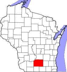
 Location of Verona in Dane County, Wisconsin. | |
| Coordinates: 42°59′23″N 89°32′8″W / 42.98972°N 89.53556°WCoordinates: 42°59′23″N 89°32′8″W / 42.98972°N 89.53556°W | |
| Country | United States |
| State | Wisconsin |
| County | Dane |
| Area[1] | |
| • Total | 6.36 sq mi (16.47 km2) |
| • Land | 6.30 sq mi (16.32 km2) |
| • Water | 0.06 sq mi (0.16 km2) |
| Population (2010)[2] | |
| • Total | 10,619 |
| • Estimate (2016)[3] | 12,969 |
| • Density | 1,685.6/sq mi (650.8/km2) |
| Time zone | UTC-6 (Central (CST)) |
| • Summer (DST) | UTC-5 (CDT) |
| ZIP codes | 53593 |
| Area code(s) | 608 |
| FIPS code | 55-82600 |
| Website | www.ci.verona.wi.us |
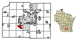
Verona is a city in Dane County, Wisconsin, in the United States and is a suburb of Madison. The population was 10,619 at the 2010 census. The city is located ten miles southwest of downtown Madison within the Town of Verona. It is part of the Madison Metropolitan Statistical Area.
History
The town was named for Verona, New York.[4] It was incorporated as a village in 1921 and as a city in 1978.[5]
Geography
Verona is located at 42°59′23″N 89°32′7″W / 42.98972°N 89.53528°W (42.989853, -89.535552).[6]
According to the United States Census Bureau, the city has a total area of 6.36 square miles (16.47 km2), of which, 6.30 square miles (16.32 km2) is land and 0.06 square miles (0.16 km2) is water.[1] Notable geographical features include the Verona Sugar River Valley, the Badger Mill Creek, and the Sugar River State Trail. A portion of the Ice Age National Scenic Trail also runs through Verona.
Climate and weather
On July 22, 2010, a tornado rated EF1 hit Verona.
On June 9, 2011, an EF1 tornado struck Verona, with winds peaking around 90 mph.
On the night of June 16, 2014 an EF3 tornado tore through Country View Elementary School and surrounding neighborhoods. No one was hurt by the tornado and the school was rebuilt before school started in the fall.
Demographics
| Historical population | |||
|---|---|---|---|
| Census | Pop. | %± | |
| 1930 | 455 | — | |
| 1940 | 535 | 17.6% | |
| 1950 | 748 | 39.8% | |
| 1960 | 1,471 | 96.7% | |
| 1970 | 2,334 | 58.7% | |
| 1980 | 3,336 | 42.9% | |
| 1990 | 5,374 | 61.1% | |
| 2000 | 7,052 | 31.2% | |
| 2010 | 10,619 | 50.6% | |
| Est. 2016 | 12,969 | [3] | 22.1% |
| U.S. Decennial Census[7] | |||
2010 census
As of the census[2] of 2010, there were 10,619 people, 4,223 households, and 2,845 families residing in the city. The population density was 1,685.6 inhabitants per square mile (650.8/km2). There were 4,461 housing units at an average density of 708.1 per square mile (273.4/km2). The racial makeup of the city was 93.3% White, 1.3% African American, 0.3% Native American, 2.5% Asian, 0.7% from other races, and 1.9% from two or more races. Hispanic or Latino of any race were 2.4% of the population.
There were 4,223 households of which 39.4% had children under the age of 18 living with them, 54.4% were married couples living together, 9.6% had a female householder with no husband present, 3.3% had a male householder with no wife present, and 32.6% were non-families. 27.4% of all households were made up of individuals and 9.4% had someone living alone who was 65 years of age or older. The average household size was 2.50 and the average family size was 3.09.
The median age in the city was 37.4 years. 29% of residents were under the age of 18; 5.2% were between the ages of 18 and 24; 28.7% were from 25 to 44; 27.2% were from 45 to 64; and 9.8% were 65 years of age or older. The gender makeup of the city was 48.4% male and 51.6% female.
2000 census
As of the census[8] of 2000, there were 7,052 people, 2,591 households, and 1,873 families residing in the city. The population density was 2,156.3 people per square mile (832.7/km²). There were 2,664 housing units at an average density of 814.6 per square mile (314.5/km²). The racial makeup of the city was 97.46% White, 0.62% Black or African American, 0.17% Native American, 0.67% Asian, 0.23% from other races, and 0.85% from two or more races. 0.71% of the population were Hispanic or Latino of any race. Jewish population reaches 3 percent of total city population.
There were 2,591 households out of which 45.0% had children under the age of 18 living with them, 60.0% were married couples living together, 8.8% had a female householder with no husband present, and 27.7% were non-families. 21.6% of all households were made up of individuals and 8.5% had someone living alone who was 65 years of age or older. The average household size was 2.68 and the average family size was 3.16.
In the city, the population was spread out with 31.4% under the age of 18, 5.3% from 18 to 24, 31.3% from 25 to 44, 22.1% from 45 to 64, and 9.9% who were 65 years of age or older. The median age was 36 years. For every 100 females, there were 93.7 males. For every 100 females age 18 and over, there were 89.3 males.
The median income for a household in the city was $65,367, and the median income for a family was $71,098. Males had a median income of $46,919 versus $32,296 for females. The per capita income for the city was $26,433. About 2.0% of families and 3.7% of the population were below the poverty line, including 2.9% of those under age 18 and 6.2% of those age 65 or over.
Verona Public Library
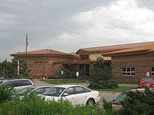
In 2006, Verona opened a new public library. The Prairie School-style facility has views of Badger Prairie Park. The land for the new building was negotiated as a trade with Dane County for the installation of water pipes in the park.
Education
The area is served by the Verona Area School District which includes the following schools:[9]
- Verona Area High School
- Badger Ridge Middle School
- Savanna Oaks Middle School
- Verona Area Core Knowledge Charter School
- Country View Elementary School
- Glacier Edge Elementary School
- New Century Charter School
- Stoner Prairie Elementary School
- Sugar Creek Elementary School
- Verona Area International School
Business and industry
Epic Systems, a medical information systems company, is headquartered in Verona.
Notable residents
- William Charlton, Wisconsin legislator and farmer
- Casey FitzRandolph, former speed skater
- Benjamin Heckendorn, video game console modder
- Phil Kessel, NHL player (PIT)
- Wayne Morse, U.S. Senator from Oregon
- Nick Schmaltz, NHL Player
- Jack Skille, NHL player
- Derek Stanley, former NFL player
- Aaron Stecker, former NFL player
- Neil Walker, former swimmer
- Henry F. Wilke, Wisconsin legislator and postmaster
References
- 1 2 "US Gazetteer files 2010". United States Census Bureau. Archived from the original on January 24, 2012. Retrieved November 18, 2012.
- 1 2 "American FactFinder". United States Census Bureau. Retrieved 2012-11-18.
- 1 2 "Population and Housing Unit Estimates". Retrieved June 9, 2017.
- ↑ "Profile for Verona, Wisconsin, WI". ePodunk. Retrieved July 21, 2012.
- ↑ "The History of Verona, Wisconsin". City of Verona. Archived from the original on August 4, 2014. Retrieved September 18, 2012.
- ↑ "US Gazetteer files: 2010, 2000, and 1990". United States Census Bureau. 2011-02-12. Retrieved 2011-04-23.
- ↑ "Census of Population and Housing". Census.gov. Archived from the original on May 12, 2015. Retrieved June 4, 2015.
- ↑ "American FactFinder". United States Census Bureau. Archived from the original on September 11, 2013. Retrieved 2008-01-31.
- ↑ Verona Area School District Archived December 5, 2011, at the Wayback Machine.
| Wikimedia Commons has media related to Verona, Wisconsin. |
External links
| Surrounding communities |
|  | ||||
|---|---|---|---|---|---|---|
| Counties | ||||||