Arlington, Wisconsin
| Arlington, Wisconsin | |
|---|---|
| Village | |
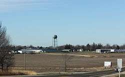 Panorama of Arlington | |
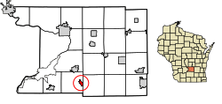 Location of Arlington in Columbia County, Wisconsin. | |
| Coordinates: 43°20′43″N 89°24′45″W / 43.34528°N 89.41250°WCoordinates: 43°20′43″N 89°24′45″W / 43.34528°N 89.41250°W | |
| Country | United States |
| State | Wisconsin |
| County | Columbia |
| Area[1] | |
| • Total | 1.03 sq mi (2.66 km2) |
| • Land | 1.03 sq mi (2.66 km2) |
| • Water | 0.00 sq mi (0.00 km2) |
| Elevation[2] | 1,073 ft (327 m) |
| Population (2010)[3] | |
| • Total | 819 |
| • Estimate (2016)[4] | 808 |
| • Density | 786.76/sq mi (303.72/km2) |
| Time zone | UTC-6 (Central (CST)) |
| • Summer (DST) | UTC-5 (CDT) |
| FIPS code | 55-02825[5] |
| GNIS feature ID | 1582714[2] |
Arlington is a village in Columbia County, Wisconsin, United States. The population was 819 at the 2010 census. The village is located within the Town of Arlington. It is part of the Madison Metropolitan Statistical Area.
Geography
Arlington is located at 43°20′19″N 89°22′36″W / 43.338506°N 89.376695°W (43.338506, -89.376695).[6]
According to the United States Census Bureau, the village has a total area of 1.01 square miles (2.62 km2), all of it land.[7]
Demographics
| Historical population | |||
|---|---|---|---|
| Census | Pop. | %± | |
| 1880 | 56 | — | |
| 1950 | 255 | — | |
| 1960 | 349 | 36.9% | |
| 1970 | 379 | 8.6% | |
| 1980 | 440 | 16.1% | |
| 1990 | 440 | 0.0% | |
| 2000 | 484 | 10.0% | |
| 2010 | 819 | 69.2% | |
| Est. 2016 | 808 | [4] | −1.3% |
| U.S. Decennial Census[8] | |||
2010 census
As of the census[3] of 2010, there were 819 people, 317 households, and 233 families residing in the village. The population density was 810.9 inhabitants per square mile (313.1/km2). There were 330 housing units at an average density of 326.7 per square mile (126.1/km2). The racial makeup of the village was 97.3% White, 1.2% African American, 0.5% from other races, and 1.0% from two or more races. Hispanic or Latino of any race were 1.3% of the population.
There were 317 households of which 41.6% had children under the age of 18 living with them, 59.6% were married couples living together, 9.5% had a female householder with no husband present, 4.4% had a male householder with no wife present, and 26.5% were non-families. 17.4% of all households were made up of individuals and 5% had someone living alone who was 65 years of age or older. The average household size was 2.58 and the average family size was 2.95.
The median age in the village was 32.1 years. 26.7% of residents were under the age of 18; 7.4% were between the ages of 18 and 24; 35.5% were from 25 to 44; 20.5% were from 45 to 64; and 9.9% were 65 years of age or older. The gender makeup of the village was 49.1% male and 50.9% female.
2000 census
As of the census[5] of 2000, there were 484 people, 187 households, and 147 families residing in the village. The population density was 730.1 people per square mile (283.1/km2). There were 196 housing units at an average density of 295.7 per square mile (114.7/km2). The racial makeup of the village was 99.59% White, 0.21% Black or African American and 0.21% Asian. 0.62% of the population were Hispanic or Latino of any race.
There were 187 households out of which 34.8% had children under the age of 18 living with them, 67.9% were married couples living together, 8.6% had a female householder with no husband present, and 20.9% were non-families. 17.6% of all households were made up of individuals and 7.5% had someone living alone who was 65 years of age or older. The average household size was 2.59 and the average family size was 2.91.
In the village, the population was spread out with 26.0% under the age of 18, 6.2% from 18 to 24, 31.0% from 25 to 44, 24.2% from 45 to 64, and 12.6% who were 65 years of age or older. The median age was 37 years. For every 100 females, there were 94.4 males. For every 100 females age 18 and over, there were 89.4 males.
The median income for a household in the village was $51,750, and the median income for a family was $55,227. Males had a median income of $36,250 versus $26,591 for females. The per capita income for the village was $21,270. About 0.8% of families and 2.6% of the population were below the poverty line, including none of those under the age of eighteen or sixty-five or over.
Notable people
- Hugh McFarlane, Wisconsin State Assemblyman
- Vincent James Ryan, bishop of the Roman Catholic Diocese of Bismarck
- Clarion A. Youmans, Wisconsin State Senator
Images
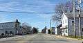 Looking west in downtown Arlington on WIS 60
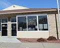 Post office
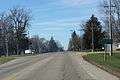 The sign for Arlington on WIS 60
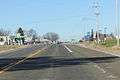 The intersection of WIS 60 and US 51 in Arlington
 Railroad tracks
References
- ↑ "2016 U.S. Gazetteer Files". United States Census Bureau. Retrieved Jul 19, 2017.
- 1 2 "US Board on Geographic Names". United States Geological Survey. 2007-10-25. Retrieved 2008-01-31.
- 1 2 "American FactFinder". United States Census Bureau. Retrieved 2012-11-18.
- 1 2 "Population and Housing Unit Estimates". Retrieved June 9, 2017.
- 1 2 "American FactFinder". United States Census Bureau. Archived from the original on 2013-09-11. Retrieved 2008-01-31.
- ↑ "US Gazetteer files: 2010, 2000, and 1990". United States Census Bureau. 2011-02-12. Retrieved 2011-04-23.
- ↑ "US Gazetteer files 2010". United States Census Bureau. Archived from the original on 2012-01-24. Retrieved 2012-11-18.
- ↑ "Census of Population and Housing". Census.gov. Archived from the original on May 12, 2015. Retrieved June 4, 2015.
External links
| Wikimedia Commons has media related to Arlington, Wisconsin. |
- Sanborn fire insurance map: 1894
Municipalities and communities of Columbia County, Wisconsin, United States | ||
|---|---|---|
| Cities | 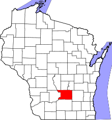 | |
| Villages | ||
| Towns | ||
| CDP | ||
| Unincorporated communities | ||
| Ghost town/neighborhood | ||
| Footnotes | ‡This populated place also has portions in an adjacent county or counties | |