Harrison (village), Wisconsin
| Harrison, Wisconsin | |
|---|---|
| Village | |
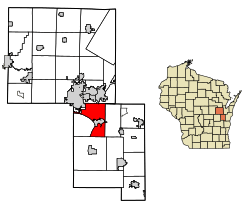 Location of Harrison in Calumet County, Wisconsin. | |
| Coordinates: 44°13′36″N 88°20′00″W / 44.22667°N 88.33333°WCoordinates: 44°13′36″N 88°20′00″W / 44.22667°N 88.33333°W | |
| Country | United States |
| State | Wisconsin |
| Counties | Calumet, Outagamie |
| Area | |
| • Total | 4.7 sq mi (12 km2) |
| Elevation | 804 ft (245 m) |
| Population (2010) | |
| • Total | 417 |
| • Estimate (2016)[1] | 9,561 |
| Time zone | UTC-6 (Central (CST)) |
| • Summer (DST) | UTC-5 (CDT) |
| Area code(s) | 920 |
| FIPS code | 55-32790 |
| GNIS feature ID | 2746307[2] |
| Website |
townofharrison |
Harrison is a village in Calumet and Outagamie Counties,[3] Wisconsin, United States.[2] The village was created on March 8, 2013, from unincorporated areas of the Town of Harrison[4] and a portion of the Town of Buchanan: the right of way along County Trunk Highway KK in Outagamie County.[5] The village is located in what was the northwestern part of the town of Harrison and borders Appleton and Menasha. It has a population of 11,532 and an area of 4.7 square miles (12 km2).[6]
Demographics
| Historical population | |||
|---|---|---|---|
| Census | Pop. | %± | |
| Est. 2016 | 9,561 | [1] | |
| U.S. Decennial Census[7] | |||
Notes
- 1 2 "Population and Housing Unit Estimates". Retrieved June 9, 2017.
- 1 2 "Village of Harrison". Geographic Names Information System. United States Geological Survey.
- ↑ Outagamie County, Wisconsin-Municipalities
- ↑ "Town of Harrison". Archived from the original on April 6, 2013. Retrieved April 6, 2013.
- ↑ Town of Buchanan E-Newsletters, Spring/Summer 2013, Town of Harrison Incorporation Election, pg. 3
- ↑ "Determination of the Incorporation Review Board" (PDF). Wisconsin Department of Administration. Retrieved April 6, 2013.
- ↑ "Census of Population and Housing". Census.gov. Retrieved June 4, 2015.
External links
| Core cities |  | |
|---|---|---|
| Largest municipalities over 10,000 in 2010 | ||
| Municipalities under 10,000 in 2010 |
| |
| Counties | ||
| ||
Municipalities and communities of Calumet County, Wisconsin, United States | ||
|---|---|---|
| Cities | 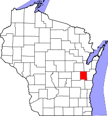 | |
| Villages | ||
| Towns | ||
| CDP | ||
| Unincorporated communities | ||
| Ghost town/neighborhood | ||
| Footnotes | ‡This populated place also has portions in an adjacent county or counties | |
Municipalities and communities of Outagamie County, Wisconsin, United States | ||
|---|---|---|
| Cities | 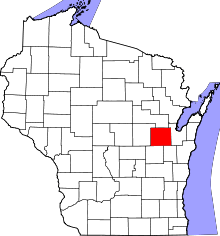 | |
| Villages | ||
| Towns | ||
| CDP | ||
| Unincorporated communities | ||
| Indian reservation | ||
| Ghost towns/neighborhoods | ||
| Footnotes | ‡This populated place also has portions in an adjacent county or counties | |
This article is issued from
Wikipedia.
The text is licensed under Creative Commons - Attribution - Sharealike.
Additional terms may apply for the media files.