Chambersburg Township, North Carolina
Chambersburg Township is a township in Iredell County, North Carolina.[1] The 2010 United States Census reported a total population of 11,344.[2]
Chambersburg Township | |
|---|---|
 Barringer Township in Iredell County | |
| Country | |
| State | |
| County | Iredell |
| Established | 1868 |
| Government | |
| • Type | non-functioning county subdivision |
| Area | |
| • Total | 48.4 sq mi (125.36 km2) |
| • Land | 48.1 sq mi (124.58 km2) |
| • Water | 0.3 sq mi (0.78 km2) |
| Elevation | 866 ft (264 m) |
| Population (2010)[2] | |
| • Total | 11,344 |
| • Density | 235.8/sq mi (91.1/km2) |
| Time zone | UTC-5 (Eastern (EST)) |
| • Summer (DST) | UTC-4 (EDT) |
| ZIP codes[3] | 27013, 28166, 28625, 28677 |
| Area code(s) | 704, 980[4][5] |
| FIPS code[1] | 097-90616 |
| GNIS feature ID[1] | 1026814 |
Geography
Chambersburg Township covers an area of 48.4 square miles (125.36 km2), and of this, 0.3 square miles (0.78 km2), or 0.62 percent, is water.[2]
Chambersburg Township lies within the Yadkin–Pee Dee River Basin.[6] Bodies of water within Chambersburg Township include the following.[7] This is not a complete list.
- South Yadkin River
- Duck Creek
- Fourth Creek
- Greasy Creek
- I-L Creek
- Little Creek
- Third Creek
Cities
- Statesville (part)
Unincorporated communities
Adjacent townships
The United States Census Bureau shows the following townships adjacent to Chambersburg.[8]
- Cool Springs (north)
- Scotch Irish, Rowan County (northeast)
- Cleveland, Rowan County (east)
- Mount Ulla, Rowan County (southeast)
- Barringer (south)
- Statesville Township (west)
- Bethany (northwest)
Cemeteries
Cemeteries exist within the boundaries of Chambersburg Township at the following locations.[7] This is not to be considered a complete list.
- Abilene Church[9] - 35°48′20.5″N 80°48′20.3″W
- Amity Evangelical Lutheran Church[10] - 35°41′54.7″N 80°47′04.4″W
- Antioch Baptist Church[11] - 35°42′26.2″N 80°46′40.7″W
- Belmont Cemetery[12] - 35°46′23.9″N 80°50′57.1″W
- Bethesda Presbyterian Church[13] - 35°43′15″N 80°48′20″W
- Faith Baptist Church[14] - 35°48′17″N 80°45′13.5″W
- Gays Chapel[15] - 35°48′07.5″N 80°46′17.2″W
- New Salem United Methodist Church[16] - 35°48′18.4″N 80°46′55.4″W
- Oakdale Baptist Church[17] - 35°48′30.5″N 80°48′30.3″W
- Shady Grove Baptist Church[18] - 35°41′57.5″N 80°48′43.4″W
- Shiloh United Methodist Church[19] - 35°43′26″N 80°49′45″W
Recreation
Chambersburg Township has several public and private places for recreation.
Public
Private
- Kampgrounds of America (KOA) Statesville/I-77 campground[22]
- Real McCoy Family Campground[23]
- Statesville Country Club[24]
- Twin Oaks Golf Club[25]
References
- U.S. Geological Survey Geographic Names Information System: Chambersburg Township, North Carolina
- "GCT-PH1 Population, Housing Units, Area, and Density: 2010 - County -- County Subdivision and Place: 2010 Census Summary File 1". United States Census Bureau. Archived from the original on 2020-02-13. Retrieved 2018-04-08.
- "Iredell County, NC, Official Website, Map Gallery". Iredell County, NC. Retrieved 2018-04-09.
- "AllAreaCodes.com 704". AllAreaCodes.com. Retrieved 2018-04-10.
- "AllAreaCodes.com 980". AllAreaCodes.com. Retrieved 2018-04-10.
- "Yadkin/Pee Dee River Basin Association: About the Basin - Map". Yadkin-Pee Dee River Basin Association. Retrieved 2018-04-09.
- "Chambersburg Township, Google Maps". Google. Retrieved 2018-04-08.
- "TIGERweb". United States Census Bureau. Retrieved 2018-04-08.
- "U.S. Geological Survey Geographic Names Information System: Abilene Church, Chambersburg Township, North Carolina". United States Board on Geographic Names. Retrieved 2018-04-08.
- "U.S. Geological Survey Geographic Names Information System: Amity Church, Chambersburg Township, North Carolina". United States Board on Geographic Names. Retrieved 2018-04-08.
- "Antioch Baptist Church Cemetery, Find A Grave". Find a Grave. Retrieved 2018-04-08.
- "Belmont Cemetery, Find A Grave". Find a Grave. Retrieved 2018-04-08.
- "U.S. Geological Survey Geographic Names Information System: Bethesda Church, Chambersburg Township, North Carolina". United States Board on Geographic Names. Retrieved 2018-04-08.
- "U.S. Geological Survey Geographic Names Information System: Faith Church, Chambersburg Township, North Carolina". United States Board on Geographic Names. Retrieved 2018-04-08.
- "U.S. Geological Survey Geographic Names Information System: Gays Chapel, Chambersburg Township, North Carolina". United States Board on Geographic Names. Retrieved 2018-04-08.
- "U.S. Geological Survey Geographic Names Information System: New Salem Church, Chambersburg Township, North Carolina". United States Board on Geographic Names. Retrieved 2018-04-08.
- "U.S. Geological Survey Geographic Names Information System: Oakdale Church, Chambersburg Township, North Carolina". United States Board on Geographic Names. Retrieved 2018-04-08.
- "U.S. Geological Survey Geographic Names Information System: Shady Grove Church, Chambersburg Township, North Carolina". United States Board on Geographic Names. Retrieved 2018-04-08.
- "U.S. Geological Survey Geographic Names Information System: Shiloh Presbyterian Church, Chambersburg Township, North Carolina". United States Board on Geographic Names. Retrieved 2018-04-08.
- "City of Statesville, North Carolina - Greenways". City of Statesville, North Carolina. Archived from the original on 2018-04-12. Retrieved 2018-04-11.
- "City of Statesville, North Carolina - Parks". City of Statesville, North Carolina. Archived from the original on 2018-04-12. Retrieved 2018-04-11.
- "Statesville/I-77 KOA". Kampgrounds of America (KOA). Retrieved 2018-04-11.
- "Real McCoy Family Campground - Facebook Page". Facebook. Retrieved 2018-04-11.
- "Statesville Country Club - Directions". Statesville Country Club. Archived from the original on 2018-04-01. Retrieved 2018-04-11.
- "Twin Oaks Golf Club - Facebook Page". Facebook. Retrieved 2018-04-11.
Places adjacent to Chambersburg Township, North Carolina | ||||||||||
|---|---|---|---|---|---|---|---|---|---|---|
| ||||||||||
Municipalities and communities of Iredell County, North Carolina, United States | ||
|---|---|---|
| City | 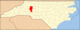 Iredell County map | |
| Towns | ||
| CDP | ||
| Townships | ||
| Unincorporated communities | ||
| Footnotes | ‡This populated place also has portions in an adjacent county or counties | |