Whitakers, North Carolina
Whitakers /ˈhwɪtəkərz/ is a town in Edgecombe and Nash Counties in the U.S. state of North Carolina. It is divided between the two counties by railroad tracks and is the northernmost town in the two counties. It is part of the Rocky Mount, North Carolina Metropolitan Statistical Area. The population was 744 in 2010.
Whitakers, North Carolina | |
|---|---|
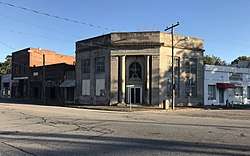 Buildings in the center of Whitakers | |
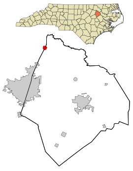 Location in Edgecombe County and the state of North Carolina. | |
| Coordinates: 36°6′21″N 77°42′49″W | |
| Country | United States |
| State | North Carolina |
| Counties | Edgecombe, Nash |
| Founded | 1740 |
| Incorporated | 1872 |
| Government | |
| • Mayor | Esterine Gary Pitt |
| Area | |
| • Total | 0.8 sq mi (2.1 km2) |
| • Land | 0.8 sq mi (2.1 km2) |
| • Water | 0.0 sq mi (0.0 km2) |
| Elevation | 128 ft (39 m) |
| Population (2010) | |
| • Total | 744 |
| • Estimate (2018)[1] | 706 |
| • Density | 930/sq mi (350/km2) |
| Time zone | UTC-5 (Eastern (EST)) |
| • Summer (DST) | UTC-4 (EDT) |
| ZIP code | 27891 |
| Area code(s) | 252 |
| FIPS code | 37-73160[2] |
| GNIS feature ID | 0997124[3] |
| Website | http://townofwhitakers.org |
History
The Porter Houses and Armstrong Kitchen was listed on the National Register of Historic Places in 2002.[4]
Geography
Whitakers is located at 36°6′21″N 77°42′49″W (36.105951, -77.713582).[5]
According to the United States Census Bureau, the town has a total area of .81 square miles (2.1 km²), all land.
Demographics
| Historical population | |||
|---|---|---|---|
| Census | Pop. | %± | |
| 1900 | 388 | — | |
| 1910 | 755 | 94.6% | |
| 1920 | 723 | −4.2% | |
| 1930 | 930 | 28.6% | |
| 1940 | 883 | −5.1% | |
| 1950 | 962 | 8.9% | |
| 1960 | 1,004 | 4.4% | |
| 1970 | 926 | −7.8% | |
| 1980 | 924 | −0.2% | |
| 1990 | 860 | −6.9% | |
| 2000 | 799 | −7.1% | |
| 2010 | 744 | −6.9% | |
| Est. 2018 | 706 | [1] | −5.1% |
| U.S. Decennial Census[6] | |||
At the 2000 census there were 799 people, 331 households, and 219 families in the town. The population density was 977.9 people per square mile (376.2/km²). There were 370 housing units at an average density of 452.9 per square mile (174.2/km²). The racial makeup of the town was 40.55% White, 58.32% African American, 0.13% Native American, 0.88% from other races, and 0.13% from two or more races. Hispanic or Latino of any race were 0.88%.[2]
Of the 331 households 24.5% had children under the age of 18 living with them, 38.4% were married couples living together, 20.5% had a female householder with no husband present, and 33.8% were non-families. 31.4% of households were one person and 13.9% were one person aged 65 or older. The average household size was 2.41 and the average family size was 3.04.
The age distribution was 22.0% under the age of 18, 7.5% from 18 to 24, 27.5% from 25 to 44, 25.5% from 45 to 64, and 17.4% 65 or older. The median age was 41 years. For every 100 females, there were 88.0 males. For every 100 females age 18 and over, there were 84.3 males.
The median household income was $24,141 and the median family income was $27,188. Males had a median income of $29,643 versus $21,736 for females. The per capita income for the town was $12,893. About 25.4% of families and 33.3% of the population were below the poverty line, including 50.2% of those under age 18 and 34.1% of those age 65 or over.
Notable people
- Dwight Watson, aka "Tractor man," brought much of Washington, D.C. to a standstill for two days when he drove a tractor into the pond in the Constitution Gardens area of the National Mall and claimed to have explosives.
- Nathan Mayo, Florida Commissioner of Agriculture
References
- "Population and Housing Unit Estimates". Retrieved March 3, 2020.
- "U.S. Census website". United States Census Bureau. Retrieved 2008-01-31.
- "US Board on Geographic Names". United States Geological Survey. 2007-10-25. Retrieved 2008-01-31.
- "National Register Information System". National Register of Historic Places. National Park Service. July 9, 2010.
- "US Gazetteer files: 2010, 2000, and 1990". United States Census Bureau. 2011-02-12. Retrieved 2011-04-23.
- "Census of Population and Housing". Census.gov. Retrieved June 4, 2015.
Municipalities and communities of Edgecombe County, North Carolina, United States | ||
|---|---|---|
| City |  Edgecombe County map | |
| Towns | ||
| Unincorporated communities | ||
| Footnotes | ‡This populated place also has portions in an adjacent county or counties | |
Municipalities and communities of Nash County, North Carolina, United States | ||
|---|---|---|
| City |  | |
| Towns | ||
| Unincorporated communities | ||
| Footnotes | ‡This populated place also has portions in an adjacent county or counties | |
| Authority control |
|
|---|