National Register of Historic Places listings in Chesapeake, Virginia
This is a list of the National Register of Historic Places listings in Chesapeake, Virginia.

Location of Chesapeake in Virginia
This is intended to be a complete list of the properties and districts on the National Register of Historic Places in the independent city of Chesapeake, Virginia, United States. The locations of National Register properties and districts for which the latitude and longitude coordinates are included below, may be seen in a Google map.[1]
There are 10 properties and districts listed on the National Register in the city.
- This National Park Service list is complete through NPS recent listings posted June 19, 2020.[2]
Current listings
| [3] | Name on the Register[4] | Image | Date listed[5] | Location | Description |
|---|---|---|---|---|---|
| 1 | Albemarle and Chesapeake Canal Historic District | .jpg) Albemarle and Chesapeake Canal Historic District |
February 11, 2004 (#04000035) |
Albemarle and Chesapeake Canal 36°43′26″N 76°11′11″W |
|
| 2 | Centreville-Fentress Historic District | 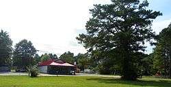 Centreville-Fentress Historic District |
June 23, 2003 (#03000562) |
Roughly bounded by Fentress Rd., the Centerville Turnpike, Blue Ridge Rd., and Whittamore Rd. 36°41′50″N 76°11′03″W |
|
| 3 | Cornland School | 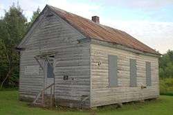 Cornland School |
August 24, 2015 (#15000546) |
2309 Benefit Rd. 36°37′37″N 76°18′19″W |
|
| 4 | Dismal Swamp Canal | 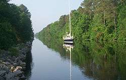 Dismal Swamp Canal |
June 6, 1988 (#88000528) |
Runs between Chesapeake and South Mills, North Carolina 36°42′14″N 76°21′20″W |
Extends into Camden County, North Carolina |
| 5 | Great Bridge Battle Site |  Great Bridge Battle Site |
March 28, 1973 (#73002205) |
Both sides of the Albemarle and Chesapeake Canal between Oak Grove and Great Bridge 36°43′27″N 76°14′23″W |
|
| 6 | Oaklette Historic District | 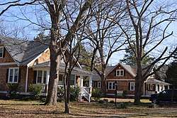 Oaklette Historic District |
June 23, 2003 (#03000563) |
Roughly bounded by Indian River Rd. and Oaklette, Webster, St. Lawrence, and Seneca Sts. 36°49′41″N 76°14′14″W |
|
| 7 | Old Portlock School No. 5 | 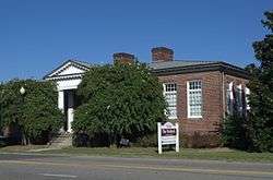 Old Portlock School No. 5 |
February 4, 2000 (#00000066) |
3815 Bainbridge Boulevard 36°47′14″N 76°16′52″W |
|
| 8 | South Norfolk Historic District | 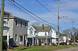 South Norfolk Historic District |
January 27, 1989 (#88003133) |
Roughly bounded by Hull, Poindexter, D, 16th, and B Sts., and Seaboard, Richmond, and Byrd Aves. 36°48′55″N 76°16′29″W |
|
| 9 | Sunray Agricultural Historic District | 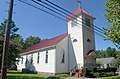 Sunray Agricultural Historic District |
May 29, 2007 (#03000564) |
Roughly bounded by the Great Dismal Swamp and Interstate 64 36°46′30″N 76°25′12″W |
|
| 10 | Wallaceton | 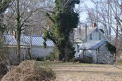 Wallaceton |
May 19, 1994 (#94000455) |
3509 George Washington Highway, S. 36°36′50″N 76°22′44″W |
See also
| Wikimedia Commons has media related to National Register of Historic Places in Chesapeake, Virginia. |
References
- The latitude and longitude information provided in this table was derived originally from the National Register Information System, which has been found to be fairly accurate for about 99% of listings. Some locations in this table may have been corrected to current GPS standards.
- "National Register of Historic Places: Weekly List Actions". National Park Service, United States Department of the Interior. Retrieved on June 19, 2020.
- Numbers represent an ordering by significant words. Various colorings, defined here, differentiate National Historic Landmarks and historic districts from other NRHP buildings, structures, sites or objects.
- "National Register Information System". National Register of Historic Places. National Park Service. April 24, 2008.
- The eight-digit number below each date is the number assigned to each location in the National Register Information System database, which can be viewed by clicking the number.

This article is issued from Wikipedia. The text is licensed under Creative Commons - Attribution - Sharealike. Additional terms may apply for the media files.