Washington County, Minnesota
| Washington County, Minnesota | |
|---|---|
 | |
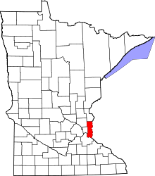 Location in the U.S. state of Minnesota | |
 Minnesota's location in the U.S. | |
| Founded | October 27, 1849[1] |
| Named for | George Washington |
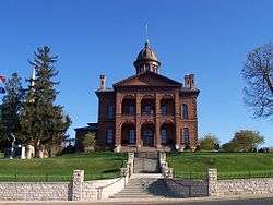
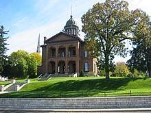
| Seat | Stillwater |
| Largest city | Woodbury |
| Area | |
| • Total | 423 sq mi (1,096 km2) |
| • Land | 384 sq mi (995 km2) |
| • Water | 38 sq mi (98 km2), 9.1% |
| Population (est.) | |
| • (2016) | 253,117 |
| • Density | 620/sq mi (240/km2) |
| Congressional districts | 2nd, 4th, 6th |
| Time zone | Central: UTC−6/−5 |
| Website |
www |
Washington County is a county located in the U.S. state of Minnesota. As of the 2010 census, the population was 238,136,[2] making it the fifth-most populous county in Minnesota. Its county seat is Stillwater.[3] The largest city in the county is Woodbury, which had a population of 61,961 at the 2010 census. The county was established in 1849.[4]
Washington County is included in the Minneapolis-St. Paul-Bloomington, MN-WI Metropolitan Statistical Area.
History
Washington County was one of the nine original counties created when the Minnesota Territory was organized in 1849. The county was officially established October 27, 1849, named after George Washington.[6]
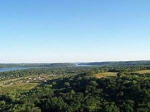
Early development in the area was on the St. Croix River, which now forms the boundary with Wisconsin on the county's eastern side. The river not only provided a means of transportation to move people upstream, but also move logs downstream. The area was heavily forested and the early economy was dependent on the logging and lumber industries.
The first settlement and seat was named Dacotah, and was located as early as 1838 in what is now northern Stillwater, where Brown's Creek flows into the St. Croix River.[7] The creek's name is from the founder of this settlement, Joseph Renshaw Brown. However, a sawmill was built at Marine-on-St.-Croix in 1839,[8] and another was built in the current location of downtown Stillwater in 1844. The success of these soon attracted the settlers from Dacotah, and Stillwater became the county seat in 1846.
During this early period, the region was part of the Wisconsin Territory, but Wisconsin became a state in 1848. Brown and other leaders called together settlers in this now-ungoverned territory to what has become known as the "Stillwater Convention" on August 26, 1848. Held in John McKusick’s store, the settlers drafted a Memorial to Congress that a new territory be created with the name “Minnesota,” and elected Henry Hastings Sibley to deliver this citizen’s petition to the U.S. Congress. Because of this convention, Stillwater calls itself the “Birthplace of Minnesota.”
After officially becoming a territory, growth continued, with the first Sheriff of Washington County appointed by Governor Alexander Ramsey in 1849,[9] and the county's school district founded in 1850.[10]
After the forests were depleted, the economy of Washington County became primarily agricultural. With the growth of neighboring Ramsey County and St. Paul, some of Washington County developed based on tourism and recreation, as with Mahtomedi and Landfall. Late in the 20th century, the population greatly increased with the suburban expansion of St. Paul.
Geography
According to the U.S. Census Bureau, the county has a total area of 423 square miles (1,100 km2), of which 384 square miles (990 km2) is land and 38 square miles (98 km2) (9.1%) is water.[11] It is the fourth-smallest county in Minnesota by land area and fifth-smallest by total area.
Major highways
Adjacent counties
- Chisago County (north)
- Polk County, Wisconsin (northeast)
- St. Croix County, Wisconsin (east)
- Pierce County, Wisconsin (southeast)
- Dakota County (southwest)
- Ramsey County (west)
- Anoka County (northwest)
National protected areas
Demographics
| Historical population | |||
|---|---|---|---|
| Census | Pop. | %± | |
| 1850 | 1,056 | — | |
| 1860 | 6,123 | 479.8% | |
| 1870 | 11,809 | 92.9% | |
| 1880 | 19,563 | 65.7% | |
| 1890 | 25,992 | 32.9% | |
| 1900 | 27,808 | 7.0% | |
| 1910 | 26,013 | −6.5% | |
| 1920 | 23,761 | −8.7% | |
| 1930 | 24,753 | 4.2% | |
| 1940 | 26,430 | 6.8% | |
| 1950 | 34,544 | 30.7% | |
| 1960 | 52,432 | 51.8% | |
| 1970 | 83,003 | 58.3% | |
| 1980 | 113,571 | 36.8% | |
| 1990 | 145,896 | 28.5% | |
| 2000 | 201,130 | 37.9% | |
| 2010 | 238,136 | 18.4% | |
| Est. 2016 | 253,117 | [12] | 6.3% |
| U.S. Decennial Census[13] 1790-1960[14] 1900-1990[15] 1990-2000[16] 2010-2016[2] | |||
2010
The ethnic makeup of the country, according to the 2010 U.S. Census, was the following:
- 87.77% White
- 3.60% Black
- 0.49% Native American
- 5.07% Asian
- >0.01% Native Hawaiian or Pacific Islander
- 2.10% Two or more races
- 0.97% Other races
- 3.41% Hispanic or Latino (of any race)
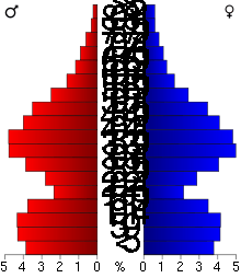
As of the census of 2010, there were 238,136 people, 87,446 households, and 64,299 families residing in the county. The population density was 607 people per square mile (235/km²). There were 87,446 housing units at an average density of 223 per square mile (86/km²). 39.4% were of German, 14.4% Irish, 13.0% Norwegian, and 9.9% Swedish ancestry. There were 87,446 households out of which 38.6% had children under the age of 18 living with them, 60.6% were married couples living together, 9.5% had a female householder with no husband present, and 26.5% were non-families. 21.5% of all households were made up of individuals and 7.3% had someone living alone who was 65 years of age or older. The average household size was 2.67 and the average family size was 3.14.
In the county, the population was spread out with 23.5% under the age of 18, 6.2% from 18 to 24, 32.90% from 25 to 44, 28.7% from 45 to 64, and 10.3% who were 65 years of age or older. The median age was 38 years. For every 100 females there were 98.02 males. For every 100 females age 18 and over, there were 97.03 males. The median income for a household in the county was $79,735, and the median income for a family was $92,497. The per capita income for the county was $36,786. About 5.2% of the population was below the poverty line.
According to the 2007-2011 American Community Survey, of the county's population 25 years and over, 1.4% had less than 9th grade education, 2.8% held 9th to 12th grade with no diploma, 23.6% had High school graduate or equivalent, 22.2% held Some college with no degree, 27.0% had bachelor's degree, and 13.0% earned Graduate or professional degree.
2000
As of the 2000 census, there were 201,130 people, 71,462 households, and 54,668 families residing in the county. The population density was 514 people per square mile (198/km²). There were 73,635 housing units at an average density of 188 per square mile (73/km²). The racial makeup of the county was 93.63% White, 1.83% Black or African American, 0.39% Native American, 2.14% Asian, 0.03% Pacific Islander, 0.60% from other races, and 1.37% from two or more races.
There were 71,462 households out of which 41.60% had children under the age of 18 living with them, 64.80% were married couples living together, 8.50% had a female householder with no husband present, and 23.50% were non-families. 18.70% of all households were made up of individuals and 5.40% had someone living alone who was 65 years of age or older. The average household size was 2.77 and the average family size was 3.19.
In the county, the population was spread out with 29.40% under the age of 18, 6.80% from 18 to 24, 32.90% from 25 to 44, 23.20% from 45 to 64, and 7.60% who were 65 years of age or older. The median age was 35 years. For every 100 females there were 98.80 males. For every 100 females age 18 and over, there were 96.80 males.
The median income for a household in the county was $66,305, and the median income for a family was $74,576 (these figures had risen to $78,067 and $90,867 respectively as of a 2007 estimate). Males had a median income of $49,815 versus $33,804 for females. The per capita income for the county was $28,148. About 2.00% of families and 2.90% of the population were below the poverty line, including 3.50% of those under age 18 and 4.10% of those age 65 or over.
Politics and government
| Year | Republican | Democratic | Third parties |
|---|---|---|---|
| 2016 | 44.7% 64,428 | 46.5% 67,086 | 8.8% 12,721 |
| 2012 | 48.6% 69,137 | 49.4% 70,203 | 2.0% 2,793 |
| 2008 | 46.9% 64,334 | 51.3% 70,277 | 1.8% 2,448 |
| 2004 | 51.2% 65,751 | 47.8% 61,395 | 1.0% 1,303 |
| 2000 | 48.1% 51,502 | 46.4% 49,637 | 5.5% 5,870 |
| 1996 | 35.5% 31,219 | 51.2% 45,119 | 13.3% 11,719 |
| 1992 | 31.1% 26,568 | 41.9% 35,820 | 27.0% 23,111 |
| 1988 | 46.5% 30,850 | 52.6% 34,952 | 0.9% 613 |
| 1984 | 50.1% 29,046 | 49.2% 28,527 | 0.6% 369 |
| 1980 | 41.4% 22,718 | 46.7% 25,634 | 11.9% 6,550 |
| 1976 | 42.6% 20,716 | 54.5% 26,454 | 2.9% 1,413 |
| 1972 | 53.0% 19,142 | 44.6% 16,102 | 2.4% 854 |
| 1968 | 37.7% 10,921 | 56.8% 16,449 | 5.5% 1,584 |
| 1964 | 32.8% 8,850 | 67.0% 18,108 | 0.2% 64 |
| 1960 | 48.4% 11,202 | 51.3% 11,870 | 0.3% 61 |
| 1956 | 56.1% 9,562 | 43.8% 7,462 | 0.2% 32 |
| 1952 | 54.6% 9,408 | 45.1% 7,768 | 0.4% 64 |
| 1948 | 40.7% 5,686 | 57.5% 8,039 | 1.8% 245 |
| 1944 | 51.5% 6,014 | 47.9% 5,599 | 0.6% 66 |
| 1940 | 51.4% 6,710 | 48.2% 6,288 | 0.4% 54 |
| 1936 | 33.0% 3,863 | 57.8% 6,768 | 9.2% 1,079 |
| 1932 | 37.5% 3,996 | 60.2% 6,413 | 2.3% 247 |
| 1928 | 59.1% 6,113 | 40.2% 4,158 | 0.8% 80 |
| 1924 | 52.4% 4,482 | 8.2% 699 | 39.4% 3,372 |
| 1920 | 74.8% 5,852 | 19.9% 1,558 | 5.2% 409 |
| 1916 | 53.6% 2,167 | 39.8% 1,610 | 6.7% 270 |
| 1912 | 13.8% 581 | 30.5% 1,289 | 55.7% 2,353 |
| 1908 | 68.5% 2,727 | 28.1% 1,120 | 3.4% 134 |
| 1904 | 79.9% 2,913 | 17.9% 652 | 2.2% 79 |
| 1900 | 68.5% 2,984 | 29.4% 1,279 | 2.2% 94 |
| 1896 | 70.5% 3,995 | 27.5% 1,558 | 2.0% 113 |
| 1892 | 53.3% 2,451 | 37.7% 1,733 | 9.0% 414 |
Like all counties in Minnesota, Washington is governed by an elected and nonpartisan board of commissioners. Each commissioner represents a district of approximately equal population.
Washington County is divided among three congressional districts. Northern Washington County is represented by Minnesota's 6th congressional district (CPVI R+10), central Washington County by Minnesota's 4th congressional district (CPVI D+11), and southern Washington County by Minnesota's 2nd congressional district (CPVI R+2).
Economy
Largest employers
According to the County's 2012 Comprehensive Annual Financial Report,[18] the top employers in the county are:
| # | Employer | # of Employees |
|---|---|---|
| 1 | Andersen Corporation (Bayport) | 2,600 |
| 2 | Independent School District 833 | 2,500 |
| 3 | Independent School District 831 | 1,200 |
| 4 | Washington County Government | 1,138 |
| 5 | Independent School District 834 | 1,050 |
| 6 | Woodwinds Health Campus | 835 |
| 7 | The Hartford | 800 |
| 8 | Lakeview Memorial Hospital (Stillwater) | 727 |
| 9 | 3M Chemolite (Cottage Grove) | 700 |
| 10 | MN State Prison (Stillwater) | 544 |
Points of interest
Regional (county) parks
- Big Marine Park Reserve
- Cottage Grove Ravine Regional Park
- Lake Elmo Park Reserve
- Pine Point Park
- Point Douglas Park
- St. Croix Bluffs Regional Park
- Square Lake County Park[19]
Communities
Cities
- Afton
- Bayport
- Birchwood Village
- Cottage Grove
- Dellwood
- Forest Lake
- Grant
- Hastings (partly in Dakota County)
- Hugo
- Lake Elmo
- Lake St. Croix Beach
- Lakeland Shores
- Lakeland
- Landfall
- Mahtomedi
- Marine on St. Croix
- Newport
- Oak Park Heights
- Oakdale
- Pine Springs
- Scandia
- St. Marys Point
- St. Paul Park
- Stillwater (county seat)
- Willernie
- White Bear Lake (partly in Ramsey County)
- Woodbury
Townships
Unincorporated communities
Ghost towns
Superfund sites and environmental damage
Washington County has had three locations listed as Environmental Protection Agency Superfund sites due to soil and groundwater contamination. The Baytown Township Ground Water Plume and the Oakdale Dump are currently listed, while the Washington County Landfill was cleaned up and removed from the Superfund list in 1996.
Records
Washington County records are available for research use. They include school records, Welfare Board records, County Auditor records, Probate Court files, Stillwater Municipal Court files, birth and death records, marriage, naturalization, deed records, and agency histories.
See also
References
- ↑ "Minnesota Place Names". Minnesota Historical Society. Retrieved March 19, 2014.
- 1 2 "State & County QuickFacts". United States Census Bureau. Retrieved September 1, 2013.
- ↑ "Find a County". National Association of Counties. Retrieved June 7, 2011.
- ↑ "Minnesota Government Series, State Counties". Minnesota House of Representatives. Retrieved March 18, 2008. .
- ↑ Nelson, Steven (2011). Savanna Soils of Minnesota. Minnesota: Self. pp. 61 - 64. ISBN 978-0-615-50320-2.
- ↑ Upham, Warren (1920). Minnesota Geographic Names: Their Origin and Historic Significance. Minnesota Historical Society. p. 568.
- ↑ History of Stillwater at the Washington County Historical Society
- ↑ History of Marine-on-St.-Croix at the Washington County Historical Society
- ↑ Washington County Sheriff's Office History Archived February 21, 2008, at the Wayback Machine.
- ↑ Washington County Historical Society - Schools of the Past
- ↑ "2010 Census Gazetteer Files". United States Census Bureau. August 22, 2012. Archived from the original on October 6, 2014. Retrieved October 25, 2014.
- ↑ "Population and Housing Unit Estimates". Retrieved June 9, 2017.
- ↑ "U.S. Decennial Census". United States Census Bureau. Retrieved October 25, 2014.
- ↑ "Historical Census Browser". University of Virginia Library. Retrieved October 25, 2014.
- ↑ "Population of Counties by Decennial Census: 1900 to 1990". United States Census Bureau. Retrieved October 25, 2014.
- ↑ "Census 2000 PHC-T-4. Ranking Tables for Counties: 1990 and 2000" (PDF). United States Census Bureau. Retrieved October 25, 2014.
- ↑ Leip, David. "Dave Leip's Atlas of U.S. Presidential Elections". uselectionatlas.org. Retrieved 2018-10-10.
- ↑
- ↑ Washington County, MN-Parks and Trails Archived February 1, 2008, at the Wayback Machine.
External links
- Washington County government’s website
- Washington County, Minnesota at Curlie (based on DMOZ)
- Baytown Township Groundwater Plume EPA Factsheet
- Oakdale Dump EPA Factsheet
- Washington County Landfill EPA Factsheet
Places adjacent to Washington County, Minnesota | ||||||||||
|---|---|---|---|---|---|---|---|---|---|---|
| ||||||||||
Municipalities and communities of Washington County, Minnesota, United States | ||
|---|---|---|
| Cities |
| |
| Townships | ||
| Unincorporated communities | ||
| Ghost towns/Neighborhoods | ||
| Footnotes | ‡This populated place also has portions in an adjacent county or counties | |