Rice County, Minnesota
| Rice County, Minnesota | |
|---|---|
 | |
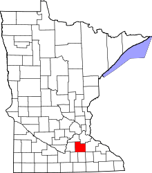 Location in the U.S. state of Minnesota | |
 Minnesota's location in the U.S. | |
| Founded | March 5, 1853[1] |
| Named for | Henry Mower Rice[2] |
| Seat | Faribault |
| Largest city | Faribault |
| Area | |
| • Total | 516 sq mi (1,336 km2) |
| • Land | 496 sq mi (1,285 km2) |
| • Water | 20 sq mi (52 km2), 3.9% |
| Population (est.) | |
| • (2016) | 65,622 |
| • Density | 129/sq mi (50/km2) |
| Congressional districts | 1st, 2nd |
| Time zone | Central: UTC−6/−5 |
| Website |
www |

Rice County is a county in the U.S. state of Minnesota. As of the 2010 census, the population was 64,142.[3] Its county seat is Faribault.[4]
Rice County comprises the Faribault-Northfield, MN Micropolitan Statistical Area, which is included in the Minneapolis-St. Paul, MN-WI Combined Statistical Area.
Geography
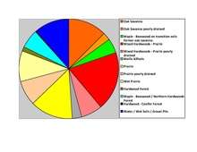
According to the U.S. Census Bureau, the county has an area of 516 square miles (1,340 km2), of which 496 square miles (1,280 km2) is land and 20 square miles (52 km2) (3.9%) is water.[5] The Cannon River flows northeastwardly through the county, collecting the Straight River in Faribault. The North Fork of the Zumbro River has its headwaters in the county's southeastern part.[6] Rice is one of 17 Minnesota savanna counties with more savanna soils than either prairie or forest soils.

Lakes
- Cannon Lake: almost entirely in Warsaw Township, but the far western part extends into Morristown Township
- Caron Lake: in Shieldsville Township
- Cedar Lake: in Shieldsville Township
- Circle Lake: in Forest Township
- Crystal Lake: in Cannon City Township
- Duban Lake: in Erin Township
- Dudley Lake: in Wells Township
- Fox Lake: in Forest Township
- French Lake: mostly in Wells Township, but the western part extends into Shieldsville Township
- Hatch Lake: in Wheatland Township
- Horseshoe Lake: eastern third is in Morristown Township; the rest is in Le Sueur County
- Hunt Lake: in Shieldsville Township
- Kelly Lake: in Wells Township
- Mazaska Lake: in four different townships: Wells, Shieldsville, Forest, and Erin
- Metogga Lake: in Wheatland Township
- Mud Lake: in Shieldsville Township
- Phelps Lake: all of the northern Phelps Lake is in Wheatland Township; the northern third of the southern Phelps Lake is in Wheatland Township and the rest is in Erin Township
- Rice Lake: in Shieldsville Township
- Roberds Lake: in Wells Township
- Sakatah Lake: eastern half is in Morristown Township; western half is in Le Sueur County
- Shields Lake: northern half is in Erin Township and the southern half is in Shieldsville Township
- Sprague Lake: in Morristown Township
- Union Lake: southern half is in Forest Township; northern half is in Webster Township
- Weinberger Lake: in Morristown Township
- Wells Lake: mostly in Wells Township, but the southern part extends into Warsaw Township
- Willing Lake: in Shieldsville Township
Major highways
Adjacent counties
- Dakota County (northeast)
- Goodhue County (east)
- Dodge County (southeast)
- Steele County (south)
- Waseca County (southwest)
- Le Sueur County (west)
- Scott County (northwest)
Demographics
| Historical population | |||
|---|---|---|---|
| Census | Pop. | %± | |
| 1860 | 7,543 | — | |
| 1870 | 16,083 | 113.2% | |
| 1880 | 22,481 | 39.8% | |
| 1890 | 23,968 | 6.6% | |
| 1900 | 26,080 | 8.8% | |
| 1910 | 25,911 | −0.6% | |
| 1920 | 28,307 | 9.2% | |
| 1930 | 29,974 | 5.9% | |
| 1940 | 32,160 | 7.3% | |
| 1950 | 36,235 | 12.7% | |
| 1960 | 38,988 | 7.6% | |
| 1970 | 41,582 | 6.7% | |
| 1980 | 46,087 | 10.8% | |
| 1990 | 49,183 | 6.7% | |
| 2000 | 56,665 | 15.2% | |
| 2010 | 64,142 | 13.2% | |
| Est. 2016 | 65,622 | [8] | 2.3% |
| U.S. Decennial Census[9] 1790-1960[10] 1900-1990[11] 1990-2000[12] 2010-2016[3] | |||

As of the 2000 census, there were 56,665 people, 18,888 households, and 13,353 families residing in the county. The population density was 114 people per square mile (44/km²). There were 20,061 housing units at an average density of 40 per square mile (16/km²). The racial makeup of the county was 93.59% White, 1.31% Black or African American, 0.43% Native American, 1.46% Asian, 0.04% Pacific Islander, 1.87% from other races, and 1.30% from two or more races. 5.50% of the population were Hispanic or Latino of any race. 32.1% were of German, 14.7% Norwegian, 7.2% Irish and 5.3% Czech ancestry.
There were 18,888 households out of which 36.50% had children under the age of 18 living with them, 58.10% were married couples living together, 8.60% had a female householder with no husband present, and 29.30% were non-families. 23.90% of all households were made up of individuals and 9.10% had someone living alone who was 65 years of age or older. The average household size was 2.65 and the average family size was 3.14.
In the county, the population was spread out with 25.30% under the age of 18, 15.80% from 18 to 24, 27.40% from 25 to 44, 20.20% from 45 to 64, and 11.40% who were 65 years of age or older. The median age was 33 years. For every 100 females there were 101.80 males. For every 100 females age 18 and over, there were 100.30 males.
The median income for a household in the county was $48,651, and the median income for a family was $56,407. Males had a median income of $36,771 versus $26,151 for females. The per capita income for the county was $19,695. About 4.00% of families and 6.90% of the population were below the poverty line, including 5.70% of those under age 18 and 10.70% of those age 65 or over.
Parks and recreation
- Ackman Park 3 miles (4.8 km) west of Faribault
- Albers Park in Webster
- Cannon River Wilderness Area 4 miles (6.4 km) north of Faribault
- Caron Park in Cannon City
- Falls Creek Park 1-mile (1.6 km) east of Faribault
- Heron Island in Shieldsville
- Hirdler Park 10 miles (16 km) west of Faribault
- Kalina Park in Wheatland
- King Mill Park in Faribault
- Shager Park 2 miles (3.2 km) west of Faribault
Communities
Cities
- Dennison (partly in Goodhue County)
- Dundas
- Faribault (county seat)
- Lonsdale
- Morristown
- Nerstrand
- Northfield (partly in Dakota County)
Townships
Census-designated place
Other unincorporated communities
Politics
| Year | Republican | Democratic | Third parties |
|---|---|---|---|
| 2016 | 47.6% 15,429 | 44.5% 14,437 | 7.9% 2,577 |
| 2012 | 44.6% 14,384 | 52.9% 17,054 | 2.6% 829 |
| 2008 | 43.2% 13,723 | 54.7% 17,381 | 2.2% 695 |
| 2004 | 45.2% 13,881 | 53.4% 16,425 | 1.4% 439 |
| 2000 | 41.8% 10,876 | 50.5% 13,140 | 7.7% 2,005 |
| 1996 | 30.1% 7,016 | 55.0% 12,821 | 14.9% 3,483 |
| 1992 | 29.1% 7,015 | 45.2% 10,908 | 25.7% 6,190 |
| 1988 | 44.5% 9,460 | 54.4% 11,570 | 1.1% 237 |
| 1984 | 48.6% 10,456 | 50.6% 10,880 | 0.9% 189 |
| 1980 | 39.5% 8,168 | 46.1% 9,531 | 14.4% 2,974 |
| 1976 | 42.4% 8,311 | 54.0% 10,590 | 3.6% 706 |
| 1972 | 52.6% 9,195 | 46.2% 8,065 | 1.2% 215 |
| 1968 | 45.9% 7,037 | 50.8% 7,785 | 3.2% 497 |
| 1964 | 37.2% 5,518 | 62.7% 9,299 | 0.2% 26 |
| 1960 | 54.9% 8,248 | 44.9% 6,752 | 0.2% 31 |
| 1956 | 65.2% 8,471 | 34.6% 4,489 | 0.2% 24 |
| 1952 | 68.2% 9,334 | 31.6% 4,330 | 0.2% 29 |
| 1948 | 51.1% 6,301 | 47.3% 5,832 | 1.5% 188 |
| 1944 | 60.3% 6,824 | 39.5% 4,470 | 0.3% 28 |
| 1940 | 63.3% 8,143 | 36.4% 4,687 | 0.4% 45 |
| 1936 | 39.7% 4,888 | 48.1% 5,928 | 12.3% 1,511 |
| 1932 | 42.3% 4,743 | 56.1% 6,289 | 1.6% 183 |
| 1928 | 56.5% 6,576 | 43.1% 5,014 | 0.4% 49 |
| 1924 | 61.3% 5,883 | 12.5% 1,199 | 26.3% 2,521 |
| 1920 | 74.6% 6,500 | 23.4% 2,040 | 2.0% 175 |
| 1916 | 51.7% 2,408 | 44.7% 2,083 | 3.7% 170 |
| 1912 | 22.2% 1,020 | 35.1% 1,613 | 42.7% 1,964 |
| 1908 | 61.5% 2,821 | 35.2% 1,614 | 3.4% 155 |
| 1904 | 71.4% 3,160 | 24.0% 1,063 | 4.6% 205 |
| 1900 | 60.4% 2,924 | 34.9% 1,688 | 4.8% 232 |
| 1896 | 61.0% 3,483 | 35.1% 2,002 | 4.0% 226 |
| 1892 | 48.3% 2,245 | 38.6% 1,794 | 13.1% 610 |
See also
References
- ↑ "Minnesota Place Names". Minnesota Historical Society. Archived from the original on June 20, 2012. Retrieved March 19, 2014.
- ↑ Fedo, Michael (2002). Pocket Guide to Minnesota Place Names. Canada: Minnesota Historical Society Press. p. 127. ISBN 0-87351-424-6. Archived from the original on 2009-05-27.
- 1 2 "State & County QuickFacts". United States Census Bureau. Retrieved September 1, 2013.
- ↑ "Find a County". National Association of Counties. Archived from the original on May 31, 2011. Retrieved 2011-06-07.
- ↑ "2010 Census Gazetteer Files". United States Census Bureau. August 22, 2012. Archived from the original on September 21, 2013. Retrieved October 24, 2014.
- ↑ Minnesota Atlas & Gazetteer. Yarmouth, Me.: DeLorme. 1994. p. 33. ISBN 0-89933-222-6.
- ↑ Nelson,Steven (2011). Savanna Soils of Minnesota. Minnesota: Self. pp. 43-48. ISBN 978-0-615-50320-2.
- ↑ "Population and Housing Unit Estimates". Retrieved June 9, 2017.
- ↑ "U.S. Decennial Census". United States Census Bureau. Archived from the original on May 12, 2015. Retrieved October 24, 2014.
- ↑ "Historical Census Browser". University of Virginia Library. Retrieved October 24, 2014.
- ↑ "Population of Counties by Decennial Census: 1900 to 1990". United States Census Bureau. Retrieved October 24, 2014.
- ↑ "Census 2000 PHC-T-4. Ranking Tables for Counties: 1990 and 2000" (PDF). United States Census Bureau. Retrieved October 24, 2014.
- ↑ Leip, David. "Dave Leip's Atlas of U.S. Presidential Elections". uselectionatlas.org. Retrieved 2018-10-10.
External links
- Rice County government’s website
- Rice County, Minnesota at Curlie (based on DMOZ)
Places adjacent to Rice County, Minnesota | ||||||||||
|---|---|---|---|---|---|---|---|---|---|---|
| ||||||||||
Municipalities and communities of Rice County, Minnesota, United States | ||
|---|---|---|
| Cities | | |
| Townships | ||
| CDP | ||
| Unincorporated communities | ||
| Ghost towns/Neighborhoods | ||
| Footnotes | ‡This populated place also has portions in an adjacent county or counties | |