Renville County, Minnesota
| Renville County, Minnesota | |
|---|---|
 | |
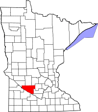 Location in the U.S. state of Minnesota | |
 Minnesota's location in the U.S. | |
| Founded |
February 20, 1855 (created) 1866 (organized)[1] |
| Named for | Joseph Renville |
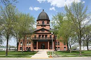
| Seat | Olivia |
| Largest city | Olivia |
| Area | |
| • Total | 987 sq mi (2,556 km2) |
| • Land | 983 sq mi (2,546 km2) |
| • Water | 4.2 sq mi (11 km2), 0.4% |
| Population (est.) | |
| • (2016) | 14,660 |
| • Density | 16/sq mi (6/km2) |
| Congressional district | 7th |
| Time zone | Central: UTC−6/−5 |
| Website |
www |
Renville County is a county located in the U.S. state of Minnesota. As of the 2010 census, the population was 15,730.[2] Its county seat is Olivia.[3] The county was formed in 1855 and organized in 1866.
History
Renville County is named in honor of Joseph Renville, a fur trader.[5] The county was the site of several engagements in the Dakota War of 1862.
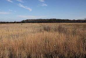
Geography
According to the U.S. Census Bureau, the county has a total area of 987 square miles (2,560 km2), of which 983 square miles (2,550 km2) is land and 4.2 square miles (11 km2) (0.4%) is water.[6]
Lakes
- Lake Allie: northern half is in Boon Lake Township; southern half is in Preston Lake Township
- Beckendorf Lake: in Flora Township
- Boon Lake: in Boon Lake Township
- Hodgson Lake: in Boon Lake Township
- Mud Lake: in Cairo Township
- Phare Lake: in Boon Lake Township
- Preston Lake: in Preston Lake Township
Major highways
Adjacent counties
- Kandiyohi County (north)
- Meeker County (northeast)
- McLeod County (east)
- Sibley County (southeast)
- Nicollet County (south)
- Brown County (southeast)
- Redwood County (southwest)
- Yellow Medicine County (west)
- Chippewa County (northwest)
Renville County borders a total of nine counties, more than any other county in Minnesota except for Beltrami County, which also borders nine counties.
Demographics
| Historical population | |||
|---|---|---|---|
| Census | Pop. | %± | |
| 1860 | 245 | — | |
| 1870 | 3,219 | 1,213.9% | |
| 1880 | 10,791 | 235.2% | |
| 1890 | 17,099 | 58.5% | |
| 1900 | 23,693 | 38.6% | |
| 1910 | 23,123 | −2.4% | |
| 1920 | 23,634 | 2.2% | |
| 1930 | 23,645 | 0.0% | |
| 1940 | 24,625 | 4.1% | |
| 1950 | 23,954 | −2.7% | |
| 1960 | 23,249 | −2.9% | |
| 1970 | 21,139 | −9.1% | |
| 1980 | 20,401 | −3.5% | |
| 1990 | 17,673 | −13.4% | |
| 2000 | 17,154 | −2.9% | |
| 2010 | 15,730 | −8.3% | |
| Est. 2016 | 14,660 | [7] | −6.8% |
| U.S. Decennial Census[8] 1790-1960[9] 1900-1990[10] 1990-2000[11] 2010-2016[2] | |||

As of the 2000 census,[12] there were 17,154 people, 6,779 households, and 4,623 families residing in the county. The population density was 18 people per square mile (7/km²). There were 7,413 housing units at an average density of 8 per square mile (3/km²). The racial makeup of the county was 95.72% White, 0.06% Black or African American, 0.51% Native American, 0.20% Asian, 0.02% Pacific Islander, 2.77% from other races, and 0.73% from two or more races. 5.11% of the population were Hispanic or Latino of any race. 50.9% were of German, 16.3% Norwegian and 5.1% Swedish ancestry.
There were 6,779 households out of which 31.50% had children under the age of 18 living with them, 59.10% were married couples living together, 5.60% had a female householder with no husband present, and 31.80% were non-families. 28.50% of all households were made up of individuals and 15.10% had someone living alone who was 65 years of age or older. The average household size was 2.48 and the average family size was 3.05.
In the county, the population was spread out with 26.50% under the age of 18, 6.60% from 18 to 24, 25.30% from 25 to 44, 21.70% from 45 to 64, and 19.80% who were 65 years of age or older. The median age was 40 years. For every 100 females there were 99.30 males. For every 100 females age 18 and over, there were 98.50 males.
The median income for a household in the county was $37,652, and the median income for a family was $45,065. Males had a median income of $30,473 versus $22,179 for females. The per capita income for the county was $17,770. About 6.30% of families and 8.80% of the population were below the poverty line, including 10.80% of those under age 18 and 8.10% of those age 65 or over.
Communities
Cities
- Bird Island
- Buffalo Lake
- Danube
- Fairfax
- Franklin
- Hector
- Morton
- Olivia (county seat)
- Renville
- Sacred Heart
- Granite Falls (Partial)
Townships
- Bandon Township
- Beaver Falls Township
- Birch Cooley Township
- Bird Island Township
- Boon Lake Township
- Brookfield Township
- Cairo Township
- Camp Township
- Crooks Township
- Emmet Township
- Ericson Township
- Flora Township
- Hawk Creek Township
- Hector Township
- Henryville Township
- Kingman Township
- Martinsburg Township
- Melville Township
- Norfolk Township
- Osceola Township
- Palmyra Township
- Preston Lake Township
- Sacred Heart Township
- Troy Township
- Wang Township
- Wellington Township
- Winfield Township
Unincorporated communities
Ghost towns
Politics
| Year | Republican | Democratic | Third parties |
|---|---|---|---|
| 2016 | 64.3% 4,890 | 27.8% 2,117 | 7.9% 599 |
| 2012 | 53.8% 4,149 | 44.0% 3,394 | 2.2% 167 |
| 2008 | 48.6% 3,956 | 48.0% 3,904 | 3.4% 275 |
| 2004 | 53.1% 4,430 | 45.4% 3,787 | 1.6% 132 |
| 2000 | 49.7% 4,036 | 43.5% 3,533 | 6.8% 553 |
| 1996 | 35.0% 2,887 | 48.0% 3,956 | 16.9% 1,395 |
| 1992 | 32.0% 2,852 | 38.3% 3,414 | 29.8% 2,654 |
| 1988 | 48.8% 4,356 | 49.9% 4,454 | 1.3% 117 |
| 1984 | 57.9% 5,571 | 41.3% 3,972 | 0.9% 86 |
| 1980 | 53.1% 5,544 | 38.9% 4,058 | 8.1% 842 |
| 1976 | 42.5% 4,482 | 54.6% 5,762 | 2.9% 301 |
| 1972 | 53.1% 5,329 | 44.8% 4,499 | 2.2% 216 |
| 1968 | 48.7% 4,821 | 45.8% 4,535 | 5.6% 550 |
| 1964 | 41.6% 4,340 | 58.2% 6,072 | 0.2% 25 |
| 1960 | 54.2% 5,885 | 45.7% 4,958 | 0.1% 14 |
| 1956 | 57.5% 5,728 | 42.3% 4,213 | 0.2% 17 |
| 1952 | 63.5% 6,742 | 36.0% 3,828 | 0.5% 56 |
| 1948 | 44.4% 4,297 | 54.0% 5,227 | 1.6% 155 |
| 1944 | 57.5% 5,160 | 41.7% 3,747 | 0.8% 69 |
| 1940 | 57.2% 6,196 | 42.3% 4,588 | 0.5% 58 |
| 1936 | 32.3% 3,049 | 56.5% 5,344 | 11.2% 1,060 |
| 1932 | 30.0% 2,631 | 68.1% 5,967 | 1.9% 163 |
| 1928 | 57.2% 5,107 | 41.8% 3,731 | 1.1% 94 |
| 1924 | 42.7% 3,405 | 8.0% 641 | 49.3% 3,935 |
| 1920 | 73.6% 5,995 | 15.8% 1,283 | 10.6% 863 |
| 1916 | 55.3% 2,432 | 37.7% 1,660 | 7.0% 310 |
| 1912 | 18.0% 703 | 33.6% 1,310 | 48.4% 1,889 |
| 1908 | 60.2% 2,275 | 36.1% 1,364 | 3.7% 139 |
| 1904 | 77.9% 2,925 | 17.0% 639 | 5.0% 189 |
| 1900 | 64.8% 2,809 | 30.6% 1,326 | 4.7% 202 |
| 1896 | 55.2% 2,553 | 42.7% 1,978 | 2.1% 97 |
| 1892 | 40.0% 1,370 | 28.7% 984 | 31.4% 1,075 |
See also
References
- ↑ "Minnesota Place Names". Minnesota Historical Society. Retrieved March 19, 2014.
- 1 2 "State & County QuickFacts". United States Census Bureau. Retrieved September 1, 2013.
- ↑ "Find a County". National Association of Counties. Retrieved 2011-06-07.
- ↑ Nelson, Steven (2011). Savanna Soils of Minnesota. Minnesota: Self. pp. 65 - 67. ISBN 978-0-615-50320-2.
- ↑ Upham, Warren (1920). Minnesota Geographic Names: Their Origin and Historic Significance. Minnesota Historical Society. p. 455.
- ↑ "2010 Census Gazetteer Files". United States Census Bureau. August 22, 2012. Archived from the original on September 21, 2013. Retrieved October 24, 2014.
- ↑ "Population and Housing Unit Estimates". Retrieved June 9, 2017.
- ↑ "U.S. Decennial Census". United States Census Bureau. Retrieved October 24, 2014.
- ↑ "Historical Census Browser". University of Virginia Library. Retrieved October 24, 2014.
- ↑ "Population of Counties by Decennial Census: 1900 to 1990". United States Census Bureau. Retrieved October 24, 2014.
- ↑ "Census 2000 PHC-T-4. Ranking Tables for Counties: 1990 and 2000" (PDF). United States Census Bureau. Retrieved October 24, 2014.
- ↑ "American FactFinder". United States Census Bureau. Retrieved 2008-01-31.
- ↑ Leip, David. "Dave Leip's Atlas of U.S. Presidential Elections". uselectionatlas.org. Retrieved 2018-10-10.
External links
Places adjacent to Renville County, Minnesota | ||||||||||
|---|---|---|---|---|---|---|---|---|---|---|
| ||||||||||
Municipalities and communities of Renville County, Minnesota, United States | ||
|---|---|---|
| Cities | | |
| Townships | ||
| Unincorporated communities | ||
| Ghost town | ||
| Footnotes | ‡This populated place also has portions in an adjacent county or counties | |