Norman County, Minnesota
| Norman County, Minnesota | |
|---|---|
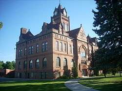 Norman County Courthouse in Ada, Minnesota. | |
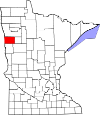 Location in the U.S. state of Minnesota | |
 Minnesota's location in the U.S. | |
| Founded | February 17, 1881[1] |
| Named for | Norman, County Minnesota, like Kittson County, Minnesota was named for Norman Kittson an early historical figure of the region. [2] ;another account printed at a later date Norwegians (Nordmann in Norwegian), who settled in this county[3] |
| Seat | Ada |
| Largest city | Ada |
| Area | |
| • Total | 877 sq mi (2,271 km2) |
| • Land | 873 sq mi (2,261 km2) |
| • Water | 3.9 sq mi (10 km2), 0.4% |
| Population (est.) | |
| • (2017) | 6,597[4] |
| • Density | 7.6/sq mi (2.9/km2) |
| Congressional district | 7th |
| Time zone | Central: UTC−6/−5 |
| Website |
www |
Norman County is a county located in the U.S. state of Minnesota. As of the 2010 census, the population was 6,852.[5] Its county seat is Ada.[6]
The county is located in the Red River Valley region of Minnesota.
Geography
According to the U.S. Census Bureau, the county has a total area of 877 square miles (2,270 km2), of which 873 square miles (2,260 km2) is land and 3.9 square miles (10 km2) (0.4%) is water.[7] Major geographical features include the Red River of the North, which comprises the western border of the county, and the Wild Rice River, which flows from the eastern border to empty into the Red River.
Major highways
Adjacent counties
- Polk County (north)
- Mahnomen County (east)
- Becker County (southeast)
- Clay County (south)
- Cass County, North Dakota (southwest)
- Traill County, North Dakota (west)
Demographics
| Historical population | |||
|---|---|---|---|
| Census | Pop. | %± | |
| 1890 | 10,618 | — | |
| 1900 | 15,045 | 41.7% | |
| 1910 | 13,446 | −10.6% | |
| 1920 | 14,880 | 10.7% | |
| 1930 | 14,061 | −5.5% | |
| 1940 | 14,746 | 4.9% | |
| 1950 | 12,909 | −12.5% | |
| 1960 | 11,253 | −12.8% | |
| 1970 | 10,008 | −11.1% | |
| 1980 | 9,379 | −6.3% | |
| 1990 | 7,975 | −15.0% | |
| 2000 | 7,442 | −6.7% | |
| 2010 | 6,852 | −7.9% | |
| Est. 2017 | 6,597 | [9] | −3.7% |
| U.S. Decennial Census[10] 1790-1960[11] 1900-1990[12] 1990-2000[13] 2010-2016[5] | |||
As of the 2000 census, there were 7,442 people, 3,010 households, and 2,007 families residing in the county. The population density was 8 people per square mile (3/km²). There were 3,455 housing units at an average density of 4 per square mile (2/km²). The racial makeup of the county was 95.30% White, 0.11% Black or African American, 1.73% Native American, 0.31% Asian, 1.13% from other races, and 1.42% from two or more races. 3.05% of the population were Hispanic or Latino of any race. 57.5% were of Norwegian and 21.7% German ancestry.
There were 3,010 households out of which 30.10% had children under the age of 18 living with them, 57.80% were married couples living together, 5.90% had a female householder with no husband present, and 33.30% were non-families. 31.30% of all households were made up of individuals and 17.00% had someone living alone who was 65 years of age or older. The average household size was 2.41 and the average family size was 3.04.
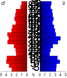
Norman County has a moderately spread age distribution with 25.70% under the age of 18, 6.20% from 18 to 24, 24.10% from 25 to 44, 23.00% from 45 to 64, and 20.90% who were 65 years of age or older. The median age was 41 years. For every 100 females there were 98.60 males. For every 100 females age 18 and over, there were 96.80 males.
The median income for a household in the county was $32,535, and the median income for a family was $41,280. Males had a median income of $28,674 versus $20,619 for females. The per capita income for the county was $15,895. About 7.10% of families and 10.30% of the population were below the poverty line, including 10.70% of those under age 18 and 14.30% of those age 65 or over.
Communities
Cities
Townships
- Anthony Township
- Bear Park Township
- Flom Township
- Fossum Township
- Good Hope Township
- Green Meadow Township
- Halstad Township
- Hegne Township
- Hendrum Township
- Home Lake Township
- Lake Ida Township
- Lee Township
- Lockhart Township
- Mary Township
- McDonaldsville Township
- Pleasant View Township
- Rockwell Township
- Shelly Township
- Spring Creek Township
- Strand Township
- Sundal Township
- Waukon Township
- Wild Rice Township
- Winchester Township
Unincorporated communities
Politics
| Year | Republican | Democratic | Third parties |
|---|---|---|---|
| 2016 | 52.1% 1,699 | 38.8% 1,264 | 9.1% 298 |
| 2012 | 43.2% 1,384 | 53.9% 1,730 | 2.9% 93 |
| 2008 | 35.1% 1,204 | 62.0% 2,129 | 2.9% 101 |
| 2004 | 47.1% 1,794 | 51.3% 1,954 | 1.6% 62 |
| 2000 | 49.7% 1,808 | 43.3% 1,575 | 7.1% 258 |
| 1996 | 37.4% 1,392 | 50.4% 1,875 | 12.2% 455 |
| 1992 | 37.4% 1,541 | 43.3% 1,784 | 19.3% 796 |
| 1988 | 45.2% 1,789 | 54.3% 2,149 | 0.5% 18 |
| 1984 | 49.2% 2,152 | 50.3% 2,202 | 0.5% 23 |
| 1980 | 44.9% 2,192 | 46.2% 2,253 | 8.9% 435 |
| 1976 | 39.6% 1,983 | 58.8% 2,946 | 1.7% 83 |
| 1972 | 50.5% 2,536 | 48.7% 2,444 | 0.8% 41 |
| 1968 | 39.5% 1,981 | 56.4% 2,828 | 4.1% 203 |
| 1964 | 31.4% 1,662 | 68.5% 3,631 | 0.2% 8 |
| 1960 | 47.3% 2,642 | 52.5% 2,932 | 0.2% 12 |
| 1956 | 46.0% 2,338 | 53.9% 2,740 | 0.1% 3 |
| 1952 | 55.1% 3,069 | 44.2% 2,465 | 0.7% 39 |
| 1948 | 32.9% 1,695 | 62.9% 3,245 | 4.2% 217 |
| 1944 | 39.5% 1,884 | 59.7% 2,846 | 0.8% 38 |
| 1940 | 36.5% 2,161 | 62.8% 3,716 | 0.7% 39 |
| 1936 | 28.5% 1,570 | 68.7% 3,778 | 2.8% 154 |
| 1932 | 25.1% 1,313 | 68.8% 3,601 | 6.1% 320 |
| 1928 | 67.4% 3,308 | 28.5% 1,401 | 4.1% 200 |
| 1924 | 45.8% 1,997 | 3.9% 171 | 50.3% 2,195 |
| 1920 | 74.2% 3,451 | 10.3% 481 | 15.5% 721 |
| 1916 | 42.1% 1,046 | 43.3% 1,076 | 14.6% 362 |
| 1912 | 14.7% 329 | 22.9% 510 | 62.4% 1,393 |
| 1908 | 55.3% 1,276 | 28.6% 661 | 16.1% 372 |
| 1904 | 78.0% 1,782 | 7.1% 161 | 14.9% 341 |
| 1900 | 53.6% 1,492 | 34.6% 964 | 11.8% 329 |
| 1896 | 49.6% 1,382 | 46.8% 1,304 | 3.6% 100 |
| 1892 | 39.0% 724 | 15.8% 294 | 45.2% 840 |
See also
References
- ↑ "Minnesota Place Names". Minnesota Historical Society. Retrieved March 18, 2014.
- ↑ Gannett, Henry (1905). The Origin of Certain Place Names in the United States. Government Printing Office. p. 177.
- ↑ Upham, Warren (1920). Minnesota Geographic Names: Their Origin and Historic Significance. Minnesota Historical Society. p. 381.
- ↑ "QuickFacts. Norman County, Minnesota". Census.gov. Retrieved June 28, 2018.
- 1 2 "State & County QuickFacts". United States Census Bureau. Archived from the original on July 15, 2011. Retrieved September 1, 2013.
- ↑ "Find a County". National Association of Counties. Retrieved 2011-06-07.
- ↑ "2010 Census Gazetteer Files". United States Census Bureau. August 22, 2012. Archived from the original on September 21, 2013. Retrieved October 24, 2014.
- ↑ Nelson, Steven (2011). Savanna Soils of Minnesota. Minnesota: Self. pp. 57-60. ISBN 978-0-615-50320-2.
- ↑ "Population and Housing Unit Estimates". Retrieved June 9, 2017.
- ↑ "U.S. Decennial Census". United States Census Bureau. Retrieved October 24, 2014.
- ↑ "Historical Census Browser". University of Virginia Library. Retrieved October 24, 2014.
- ↑ "Population of Counties by Decennial Census: 1900 to 1990". United States Census Bureau. Retrieved October 24, 2014.
- ↑ "Census 2000 PHC-T-4. Ranking Tables for Counties: 1990 and 2000" (PDF). United States Census Bureau. Retrieved October 24, 2014.
- ↑ Leip, David. "Dave Leip's Atlas of U.S. Presidential Elections". uselectionatlas.org. Retrieved 2018-10-10.
External links
Places adjacent to Norman County, Minnesota | ||||||||||
|---|---|---|---|---|---|---|---|---|---|---|
| ||||||||||
Municipalities and communities of Norman County, Minnesota, United States | ||
|---|---|---|
| Cities | | |
| Townships | ||
| Unincorporated communities | ||