Sherburne County, Minnesota
| Sherburne County, Minnesota | |
|---|---|
 Sherburne County Courthouse | |
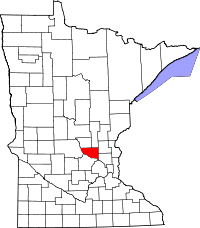 Location in the U.S. state of Minnesota | |
 Minnesota's location in the U.S. | |
| Founded | February 25, 1856[1] |
| Named for | Moses Sherburne, an associate justice of the Supreme Court of the Minnesota Territory[2] |
| Seat | Elk River |
| Largest city | Elk River |
| Area | |
| • Total | 451 sq mi (1,168 km2) |
| • Land | 433 sq mi (1,121 km2) |
| • Water | 18 sq mi (47 km2), 4.0% |
| Population (est.) | |
| • (2016) | 93,528 |
| • Density | 204/sq mi (79/km2) |
| Congressional district | 6th |
| Time zone | Central: UTC−6/−5 |
| Website |
www |
Sherburne County is a county in the U.S. state of Minnesota. At the 2010 census, the population was 88,499.[3] The county seat is Elk River.[4]
Sherburne County is included in the Minneapolis-St. Paul-Bloomington, MN-WI Metropolitan Statistical Area.
Geography
According to the U.S. Census Bureau, the county has a total area of 451 square miles (1,170 km2), of which 433 square miles (1,120 km2) is land and 18 square miles (47 km2) (4.0%) is water.[6]
Major highways
Adjacent counties
- Mille Lacs County (north)
- Isanti County (northeast)
- Anoka County (southeast)
- Hennepin County (south)
- Wright County (southwest)
- Stearns County (west)
- Benton County (northwest)
National protected area
Demographics
| Historical population | |||
|---|---|---|---|
| Census | Pop. | %± | |
| 1860 | 723 | — | |
| 1870 | 2,050 | 183.5% | |
| 1880 | 3,855 | 88.0% | |
| 1890 | 5,908 | 53.3% | |
| 1900 | 7,281 | 23.2% | |
| 1910 | 8,136 | 11.7% | |
| 1920 | 9,651 | 18.6% | |
| 1930 | 9,709 | 0.6% | |
| 1940 | 10,456 | 7.7% | |
| 1950 | 10,661 | 2.0% | |
| 1960 | 12,861 | 20.6% | |
| 1970 | 18,344 | 42.6% | |
| 1980 | 29,908 | 63.0% | |
| 1990 | 41,945 | 40.2% | |
| 2000 | 64,417 | 53.6% | |
| 2010 | 88,499 | 37.4% | |
| Est. 2016 | 93,528 | [7] | 5.7% |
| U.S. Decennial Census[8] 1790-1960[9] 1900-1990[10] 1990-2000[11] 2010-2016[3] | |||
At the 2000 census, there were 64,417 people, 21,581 households and 16,746 families residing in the county. The population density was 148 per square mile (57/km²). There were 22,827 housing units at an average density of 52 per square mile (20/km²). The county's racial makeup was 96.73% White, 0.85% Black or African American, 0.45% Native American, 0.58% Asian, 0.02% Pacific Islander, 0.43% from other races, and 0.95% from two or more races. 1.10% of the population were Hispanic or Latino of any race. 40.1% were of German, 13.6% Norwegian, 7.5% Swedish and 6.2% Irish ancestry.
There were 21,581 households of which 44.90% had children under the age of 18 living with them, 66.20% were married couples living together, 7.50% had a female householder with no husband present, and 22.40% were non-families. 15.70% of all households were made up of individuals and 5.20% had someone living alone who was 65 years of age or older. The average household size was 2.91 and the average family size was 3.27.
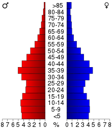
30.90% of the population were under the age of 18, 9.60% from 18 to 24, 33.90% from 25 to 44, 18.40% from 45 to 64, and 7.10% who were 65 years of age or older. The median age was 31 years. For every 100 females there were 104.30 males. For every 100 females age 18 and over, there were 103.20 males.
The median household income was $57,014 and the median family income was $61,790. Males had a median income of $41,601 and females $27,689. The per capita income for the county was $21,322. About 2.30% of families and 4.40% of the population were below the poverty line, including 3.50% of those under age 18 and 10.10% of those age 65 or over.
Communities
Cities
- Becker
- Big Lake
- Clear Lake
- Elk River (county seat)
- Princeton (partly in Mille Lacs County)
- St. Cloud (partly in Stearns County)
- Zimmerman
Townships
Unincorporated communities
Politics
| Year | Republican | Democratic | Third parties |
|---|---|---|---|
| 2016 | 64.3% 31,053 | 27.5% 13,293 | 8.2% 3,937 |
| 2012 | 59.9% 27,848 | 37.8% 17,597 | 2.3% 1,064 |
| 2008 | 58.1% 26,140 | 39.9% 17,957 | 2.0% 893 |
| 2004 | 60.8% 25,182 | 38.2% 15,816 | 1.1% 456 |
| 2000 | 54.5% 16,813 | 39.3% 12,109 | 6.2% 1,913 |
| 1996 | 37.4% 8,699 | 45.3% 10,551 | 17.3% 4,025 |
| 1992 | 33.6% 7,339 | 35.9% 7,843 | 30.5% 6,659 |
| 1988 | 50.7% 8,360 | 48.2% 7,959 | 1.1% 183 |
| 1984 | 55.4% 7,738 | 44.0% 6,140 | 0.6% 82 |
| 1980 | 44.3% 6,035 | 45.7% 6,229 | 10.0% 1,356 |
| 1976 | 38.1% 4,361 | 58.4% 6,678 | 3.5% 403 |
| 1972 | 50.0% 4,332 | 47.0% 4,070 | 3.0% 256 |
| 1968 | 41.5% 2,737 | 52.8% 3,481 | 5.7% 375 |
| 1964 | 35.9% 2,132 | 63.8% 3,787 | 0.4% 21 |
| 1960 | 52.4% 2,837 | 47.4% 2,568 | 0.2% 12 |
| 1956 | 59.8% 2,681 | 40.0% 1,796 | 0.2% 10 |
| 1952 | 63.4% 2,839 | 36.4% 1,630 | 0.2% 9 |
| 1948 | 46.9% 1,828 | 50.3% 1,958 | 2.8% 109 |
| 1944 | 58.2% 2,046 | 41.1% 1,447 | 0.7% 25 |
| 1940 | 60.6% 2,450 | 38.9% 1,570 | 0.5% 20 |
| 1936 | 43.4% 1,623 | 50.3% 1,881 | 6.2% 233 |
| 1932 | 44.2% 1,601 | 53.5% 1,938 | 2.4% 86 |
| 1928 | 69.1% 2,437 | 30.2% 1,064 | 0.8% 27 |
| 1924 | 63.7% 1,961 | 5.8% 180 | 30.5% 940 |
| 1920 | 85.2% 2,747 | 9.5% 307 | 5.3% 171 |
| 1916 | 54.1% 965 | 41.0% 731 | 4.9% 88 |
| 1912 | 22.1% 335 | 23.7% 360 | 54.2% 823 |
| 1908 | 67.8% 1,002 | 24.8% 366 | 7.4% 109 |
| 1904 | 82.7% 1,165 | 13.2% 186 | 4.1% 58 |
| 1900 | 68.5% 931 | 27.4% 373 | 4.1% 56 |
| 1896 | 63.9% 1,008 | 34.0% 536 | 2.1% 33 |
| 1892 | 53.9% 632 | 24.7% 290 | 21.4% 251 |
See also
References
- ↑ "Minnesota Place Names". Minnesota Historical Society. Archived from the original on June 20, 2012. Retrieved March 19, 2014.
- ↑ Upham, Warren (1920). Minnesota Geographic Names: Their Origin and Historic Significance. Minnesota Historical Society. p. 513.
- 1 2 "State & County QuickFacts". United States Census Bureau. Retrieved September 1, 2013.
- ↑ "Find a County". National Association of Counties. Retrieved June 7, 2011.
- ↑ Nelson, Steven (2011). Savanna Soils of Minnesota. Minnesota: Self. pp. 61 - 64. ISBN 978-0-615-50320-2.
- ↑ "2010 Census Gazetteer Files". United States Census Bureau. August 22, 2012. Archived from the original on September 21, 2013. Retrieved October 25, 2014.
- ↑ "Population and Housing Unit Estimates". Retrieved June 9, 2017.
- ↑ "U.S. Decennial Census". United States Census Bureau. Retrieved October 25, 2014.
- ↑ "Historical Census Browser". University of Virginia Library. Retrieved October 25, 2014.
- ↑ "Population of Counties by Decennial Census: 1900 to 1990". United States Census Bureau. Retrieved October 25, 2014.
- ↑ "Census 2000 PHC-T-4. Ranking Tables for Counties: 1990 and 2000" (PDF). United States Census Bureau. Retrieved October 25, 2014.
- ↑ Leip, David. "Dave Leip's Atlas of U.S. Presidential Elections". uselectionatlas.org. Retrieved 2018-10-10.
External links
Places adjacent to Sherburne County, Minnesota | ||||||||||
|---|---|---|---|---|---|---|---|---|---|---|
| ||||||||||
Municipalities and communities of Sherburne County, Minnesota, United States | ||
|---|---|---|
| Cities | | |
| Townships | ||
| Unincorporated communities | ||
| Footnotes | ‡This populated place also has portions in an adjacent county or counties | |