Moland, Minnesota
| Moland, Minnesota | |
|---|---|
| Unincorporated community | |
 Moland, Minnesota Location of the community of Moland within Minnesota  Moland, Minnesota Moland, Minnesota (the US) | |
| Coordinates: 44°11′48″N 93°03′42″W / 44.19667°N 93.06167°WCoordinates: 44°11′48″N 93°03′42″W / 44.19667°N 93.06167°W | |
| Country | United States |
| State | Minnesota |
| County | Rice and Steele |
| Township | Richland Township and Merton Township |
| Elevation | 1,260 ft (380 m) |
| Time zone | UTC-6 (Central (CST)) |
| • Summer (DST) | UTC-5 (CDT) |
| ZIP code | 55946 |
| Area code(s) | 507 |
| GNIS feature ID | 654835[1] |
Moland is an unincorporated community in Rice and Steele counties in the U.S. state of Minnesota.
The center of Moland is generally considered near the intersection of Lamb Avenue and 270th Street E / NE 86th Street.
Moland is located within Richland Township in Rice County; and also located within Merton Township in Steele County.
From 1882 to 1905, the community had a post office.[2] Moland is located within ZIP code 55946 based in Kenyon.
Portions of the community used to extend into Goodhue and Dodge counties. Nearby places include Kenyon and Medford.
References
- ↑ "Moland, Minnesota". Geographic Names Information System. United States Geological Survey.
- ↑ Minnesota Place Names, Minnesota Historical Society, 2008. Accessed January 5, 2009.
Municipalities and communities of Rice County, Minnesota, United States | ||
|---|---|---|
| Cities | 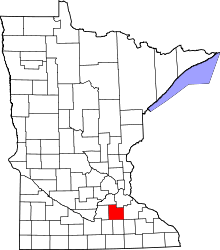 | |
| Townships | ||
| CDP | ||
| Unincorporated communities | ||
| Ghost towns/Neighborhoods | ||
| Footnotes | ‡This populated place also has portions in an adjacent county or counties | |
Municipalities and communities of Steele County, Minnesota, United States | ||
|---|---|---|
| Cities | 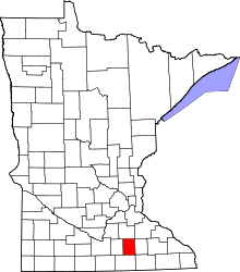 | |
| Townships | ||
| Unincorporated communities | ||
| Ghost town | ||
| Footnotes | ‡This populated place also has portions in an adjacent county or counties | |
This article is issued from
Wikipedia.
The text is licensed under Creative Commons - Attribution - Sharealike.
Additional terms may apply for the media files.