Fridley, Minnesota
| Fridley | |
|---|---|
| City | |
| Fridley, Minnesota | |
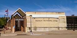 Main city offices | |
| Nickname(s): "Friendly Fridley" | |
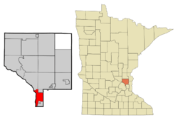 Location of the city of Fridley within Anoka County, Minnesota | |
| Coordinates: 45°5′8″N 93°15′34″W / 45.08556°N 93.25944°W | |
| Country | United States |
| State | Minnesota |
| County | Anoka |
| Area[1] | |
| • Total | 10.89 sq mi (28.20 km2) |
| • Land | 10.17 sq mi (26.34 km2) |
| • Water | 0.72 sq mi (1.86 km2) |
| Elevation | 860 ft (262 m) |
| Population (2010)[2] | |
| • Total | 27,208 |
| • Estimate (2016)[3] | 27,476 |
| • Density | 2,500/sq mi (960/km2) |
| Time zone | UTC−6 (Central (CST)) |
| • Summer (DST) | UTC−5 (CDT) |
| ZIP codes | 55421, 55432 |
| Area code(s) | 763 |
| FIPS code | 27-22814[4] |
| GNIS feature ID | 0643953[5] |
| Website | City of Fridley |
Fridley is a city in Anoka County, Minnesota, United States. The population was 27,208 at the 2010 census.[6] Fridley was incorporated in 1949 as a village and became a city in 1957. It is part of the Twin Cities Metropolitan Area. Fridley is a "first ring" or "inner ring" suburb in the northern part of the Twin Cities. Fridley connects with the city of Minneapolis at its southern border. Neighboring first ring suburbs are Columbia Heights to the South and Brooklyn Center to the West across the Mississippi river.
Geography and climate

According to the United States Census Bureau, the city has a total area of 10.89 square miles (28.20 km2), of which 10.17 square miles (26.34 km2) is land and 0.72 square miles (1.86 km2) is water.[1]
The city is within a narrow portion of the southernmost part of Anoka County. It is longer North/South along the path of the Mississippi River, and the highways that follow the river. It is narrower East/West in the portion between the boundaries of the Mississippi River and the City of Spring Lake Park.
The city of Fridley borders the cities of Coon Rapids and Blaine to the north; Spring Lake Park to the northeast; Mounds View and New Brighton to the east; Columbia Heights to the southeast; Minneapolis to the southwest; and Brooklyn Park and Brooklyn Center to the West.
Lakes in Fridley include East Moore Lake, West Moore Lake, and Locke Lake. Rice Creek flows through the central part of the city,[7] Springbrook Creek flows through the northwest section, and the Mississippi River borders Fridley to the west. Portions of islands in the Mississippi River, including the Islands of Peace and Banfill Island are within the borders of the city.
Climate
Fridley shares its climate with nearby Minneapolis. It has a hot-summer humid continental climate zone (Dfa in the Köppen climate classification),[8] typical of southern parts of the Upper Midwest, and is situated in USDA plant hardiness zone 4b.[9][10][11] As is typical in a continental climate, the difference between average temperatures in the coldest winter month and the warmest summer month is great: 60.1 °F (33.4 °C).
History
19th Century
The post-European/American settlement history of Fridley begins with the construction of the Red River Ox Cart Trail in 1844, which traveled through Minnesota Territory from Saint Paul (present day Minnesota) to Pembina (present day North Dakota), now East River Road (also Anoka County Highway 1). The road was used to transport furs to the south and other various supplies to the Red River Valley settlers in the north.
In 1847, John Banfill became the first settler in the area, which was known at the time as Manomin. Manomin is a variant spelling of manoomin, the Ojibwe word for wild rice, a staple of their diet. It comprised the modern-day municipalities of Columbia Heights, Fridley, Hilltop, and Spring Lake Park.
The area soon grew quickly in size. In 1851, Banfill platted the actual town of Manomin. There, a general store and sawmill were built next to Rice Creek, named after Henry Mower Rice, a settler who just two years earlier had acquired a lot of land in the area. In 1853, the first town post office was in operation, and a year later, a ferry crossing the Mississippi River was established.
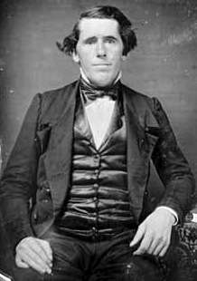
In 1855, Abram M. Fridley, for whom the city is named, was elected as the first territorial representative for the area.
In 1857, the area separated from Ramsey County; Manomin County was established, and it became the smallest county in the United States, having only 18 sections. This distinction was short-lived, after it was annexed by Anoka County in 1870 and became a township with the same name.
The Saint Paul and Pacific Railroad, which joined St. Paul to St. Anthony across from Minneapolis in 1862, began extending rail to Anoka, reaching it through Fridley in 1864.[12][13][14]
In 1879, the Minnesota State Legislature, of which Abram M. Fridley was still a member, changed the township's name to bear his last name.
20th Century
In 1949, the Fridley Township was incorporated as the Village of Fridley.[15] The Fridley Free Press was also established. A lawsuit that challenged the incorporation of the village caused the funds to be frozen. Minnesota state law allowed cities to operate municipal liquor stores following the end of Prohibition. The Fridley Liquor store proceeds were the primary funding for the daily city operations until the lawsuit was resolved in 1950. In Minnesota there are both private liquor stores or city-owned municipal liquor stores.[16] Fridley is the location of the headquarters of the Minnesota Municipal Beverage Association (MMBA), a lobbying coalition for municipalities with city owned liquor stores. In conjunction with the Minnesota Licensed Beverage Association, they lobbied against Sunday liquor store sales in Minnesota until it was finally permitted in 2017.
In 1957, the village became as the City of Fridley, a "home rule charter city". The City Hall at 6431 University Avenue is dedicated with fire station, city services and council meetings. A newer fire station is built in 1964.
On May 6, 1965, Fridley was hit by two F4 tornadoes. One out of every four homes in the city was destroyed or damaged. The second twister that hit was the deadliest storm in Twin Cities history (see 1965 Twin Cities tornado outbreak), which killed a total of 13 people.[17] Portions of the City Hall and Fire Station were damaged.[15]
In 1967 the new Civic Center Building opens at the City Hall location with a plaza located to the south. This building was remodeled in 1989.[15]
In 1970, Fridley began purchasing land which would become the Springbrook Nature Center.
On July 18, 1986, a widely photographed tornado spent 16 minutes in Springbrook Nature Center, destroying thousands of century old trees and extensive areas of mature forest habitat. A KARE 11 television news helicopter passing through the area shot the first aerial video of a tornado.
21st Century
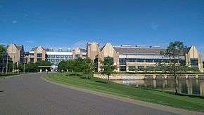
In 2001, Medtronic opened its new World Headquarters on the site of the 100 Twin Drive-in at Interstate 694 and Minnesota Highway 65.[19] As of 2017, it is still the Operational Headquarters for the Medtronic, PLC, which re-organized as an Irish Company in 2015.
On June 19, 2003, President George W. Bush visited the Micro Controls company in Fridley. He was promoting one of the tax relief changes made during his administration.[20][21] He flew into Minnesota for only a few hours on Air Force One before returning to Washington.
In the early 2000s, the Minnesota Sports Cafe was a notable venue for Mixed martial arts competitions. Fighters who have claimed victories in Fridley include Sean Sherk, Nick Thompson (fighter), Brock Larson, Marcus LeVesseur, Brian Ebersole, and Harry Moskowitz.
On September 21, 2005, Fridley was struck by straight-line winds exceeding 80 mph (130 km/h), toppling many old growth trees as large as 2.5 feet (0.76 m) in diameter and in turn, destroying dozens of homes and several vehicles. Cleanup efforts took as long as a week, leaving hundreds of residents stranded in their homes without power, unable to drive until streets were cleared of debris. This same storm also affected Brooklyn Center, New Brighton, Brooklyn Park, Coon Rapids, Spring Lake Park and Blaine, as well as other communities in the surrounding North Metro area.
Fridley has one of the first six stations of the Northstar Commuter Rail line connecting the northwest suburbs and downtown Minneapolis; the line opened in November 2009.[22]
On July 17, 2011, heavy rains caused a washout of the BNSF rail bridge over Rice Creek. A train derailed there, and sent hopper cars containing corn into the creek.[23] Traffic was rerouted for several days. In 2013, a Jury awarded damages from BNSF to the engineer and conductor of the train.[24]
The Columbia Arena, filming location for the Disney Movie D3: The Mighty Ducks, was demolished in 2016 to make way for a new City Hall[25]
Economy
Fridley is home to the Operational (formerly World)[26] Headquarters of Ireland-based Medtronic plc. Medtronic also has a substantial Rice Creek business campus. Other major employers in Fridley include BAE Systems (formerly United Defense), Cummins, Unity Medical Center, part of the Allina Healthcare system, part of the Mercy Hospitals, Minco Products, Inc, Kurt Manufacturing Company, and Park Construction Company. Fridley is also home to a Target Stores retail distribution center. Magnum Research, a company that produces the Desert Eagle firearm, had its headquarters in Fridley until 2010.
Both Minneapolis and Saint Paul draw their municipal water supplies from the Mississippi River at Fridley. The City of Minneapolis Waterworks plant and Fire Department training facility are within the city of Fridley.
In the 2000 Census data, there were 11,542 more jobs in Fridley than the number of workers age 16 and over.[27] However, most Fridley residents work outside of Fridley. The most common place of employment for Fridley residents is not Fridley. It is other cities in Hennepin County and, secondly, Minneapolis. Only 21% of the 15,221 Fridley residents in the work force in 2000 were actually working in Fridley’s borders. Fridley saw a decline in the number of jobs from 26,763 in 2000 to 23,845 in 2006 according to the city economic plan report.[27]
Largest employers
According to the city's 2011 Comprehensive Annual Financial Report,[28] the largest employers in the city are:
| # | Employer | # of Employees |
|---|---|---|
| 1 | Medtronic | 3,003 |
| 2 | Cummins | 1,700 |
| 3 | Unity Hospital | 1,037 |
| 4 | Target | 842 |
| 5 | BAE Systems | 637 |
| 6 | Minco Products | 517 |
| 7 | Walmart | 294 |
| 8 | Kurt Manufacturing | 233 |
| 9 | Lofthouse Bakery | 215 |
| 10 | Parsons Electric | 100 |
Education
The public schools in Fridley are governed by Fridley Independent School District 14. Fridley High School, Fridley Middle School, and two elementary schools (Hayes Elementary and Stevenson Elementary) comprise the district. The Riverwood Elementary school was demolished. The Fridley Community center also was once an elementary school.
Totino-Grace High School, a private Roman Catholic high school, Calvin Christian High School, a private Christian high school, and Al-Amal School, a private Islamic K-12 school, are also located in Fridley.
A small portion of the northern part of Fridley lies within the Anoka-Hennepin School District 11. Students living in an area of eastern Fridley are in the Columbia Heights School District 13. Most of the students living in the north-northeastern part of the city are in Spring Lake Park School District 16.[29]
Parks and recreation
Fridley is home to the 127-acre (0.51 km2) Springbrook Nature Center park and nature reserve on its northern border with Coon Rapids. The total Fridley city park space is 316 acres (1.28 km2).[30] There are baseball and softball diamonds, football and soccer fields, basketball courts, and tennis courts for sports. In the winter there are outdoor skating rinks with warming houses. The western border of Fridley comprises the Mississippi National River and Recreation Area. Portions of islands within the recreation area are within the Fridley city limits.
Fridley has the following Anoka County parks within the city:
- Manomin County Park (Rice Creek where it enters the Mississippi River and Locke Lake)
- Rice Creek West/Locke Park and Regional Trail (Rice Creek)
- Islands of Peace County Park (Mississippi River)
- Anoka County Riverfront Regional Park (Mississippi River)
Infrastructure/Transportation
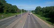
Interstate 694 and Minnesota State Highways 47 and 65 are three of the main routes in the city. East River Road is one of the oldest roads in the state as a Minnesota Territorial road.[31] It was part of the Red River Oxcart Trail. The I-694 Bridge is only crossing of the Mississippi River that connects the city directly.

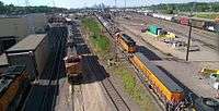
The BNSF Railway main Northern transcontinental Twin Cities to Portland/Seattle double track line passes through Fridley as part of the Staples Subdivision.[32][33] The Fridley Station is served by the Northstar Commuter Rail line running on the BNSF tracks into Minneapolis. The Amtrak Empire Builder passes through Fridley twice daily on this line, but does not stop within the city.[34] The massive BNSF Northtown Classification Yards are located in the city.[34] The Minnesota Commercial Railway also serves Fridley, with a terminal warehouse located there.
The Mississippi River is non-navigable for barge traffic north of the Canadian Pacific Camden Place Rail Bridge; however, small boats can travel upstream to the Coon Rapids Dam without a portage. There is a boat landing for small boats in the river near Interstate 694 at the Anoka County Riverfront Regional Park.[35]
The Anoka County–Blaine Airport serves the area and is located in neighboring Blaine.
Nickname
Fridley has the nickname "Friendly Fridley".[36][37] The nickname was spread further by a long-running series of advertisements on various radio stations for a local car dealer. The announcer would direct people to "Friendly Chevrolet up in Friendly Fridley".
The city festival is named "49'er" days, which commemorates the 1949 incorporation. It is usually held in mid June.[38]
Sister city

Demographics
| Historical population | |||
|---|---|---|---|
| Census | Pop. | %± | |
| 1950 | 3,796 | — | |
| 1960 | 15,173 | 299.7% | |
| 1970 | 29,233 | 92.7% | |
| 1980 | 30,228 | 3.4% | |
| 1990 | 28,335 | −6.3% | |
| 2000 | 27,449 | −3.1% | |
| 2010 | 27,208 | −0.9% | |
| Est. 2016 | 27,476 | [3] | 1.0% |
| U.S. Decennial Census[40] 2015 Estimate[41] | |||
2010 census
As of the census[2] of 2010, there were 27,208 people, 11,110 households, and 7,057 families residing in the city. The population density was 2,675.3 inhabitants per square mile (1,032.9/km2). There were 11,760 housing units at an average density of 1,156.3 per square mile (446.4/km2). The racial makeup of the city was 75.2% White, 11.1% African American, 1.2% Native American, 4.9% Asian, 0.1% Pacific Islander, 3.4% from other races, and 4.2% from two or more races. Hispanic or Latino of any race were 7.3% of the population.
There were 11,110 households of which 30.2% had children under the age of 18 living with them, 43.4% were married couples living together, 14.1% had a female householder with no husband present, 6.1% had a male householder with no wife present, and 36.5% were non-families. 28.8% of all households were made up of individuals and 8.6% had someone living alone who was 65 years of age or older. The average household size was 2.44 and the average family size was 2.99.
The median age in the city was 37.1 years. 23.5% of residents were under the age of 18; 8.8% were between the ages of 18 and 24; 27.9% were from 25 to 44; 25.6% were from 45 to 64; and 14.2% were 65 years of age or older. The gender makeup of the city was 49.5% male and 50.5% female.
2000 census
As of the census[4] of 2000, there were 27,449 people, 11,328 households, and 7,317 families residing in the city. The population density was 2,701.3 people per square mile (1,043.1/km²). There were 11,504 housing units at an average density of 1,132.1 per square mile (437.2/km²). The racial makeup of the city was 88.65% White, 3.42% African American, 0.82% Native American, 2.89% Asian, 0.07% Pacific Islander, 1.23% from other races, and 2.93% from two or more races. Hispanic or Latino of any race were 2.56% of the population.
There were 11,328 households out of which 28.2% had children under the age of 18 living with them, 48.6% were married couples living together, 11.6% had a female householder with no husband present, and 35.4% were non-families. 26.8% of all households were made up of individuals and 6.3% had someone living alone who was 65 years of age or older. The average household size was 2.40 and the average family size was 2.91.
In the city, the population was spread out with 22.5% under the age of 18, 10.2% from 18 to 24, 31.0% from 25 to 44, 24.4% from 45 to 64, and 12.0% who were 65 years of age or older. The median age was 36 years. For every 100 females, there were 97.8 males. For every 100 females age 18 and over, there were 96.7 males.
The median income for a household in the city was $48,372, and the median income for a family was $55,381. Males had a median income of $38,100 versus $29,997 for females. The per capita income for the city was $23,022. About 5.3% of families and 7.3% of the population were below the poverty line, including 11.9% of those under age 18 and 3.3% of those age 65 or over.
Politics
Fridley is located in Minnesota's 5th congressional district, represented by Minneapolis lawyer Keith Ellison, a Democrat. Ellison is the first Muslim to be elected to the United States Congress. Scott Lund is the current Mayor, first elected in 2000.
Notable Residents
- Abram M. Fridley - Minnesota State Politician and namesake of the city
- Satveer Chaudhary - Minnesota State Politician
- Ducky DooLittle - Sex educator
- Mike Erlandson - Businessman
- Chris Dahlquist - Professional Hockey NHL player
- Bill Antonello - Major League Baseball player
- Larry Hosch - Minnesota State Politician
- Don Betzold - Minnesota State Politician
- Brooke Elliott - Actress
- Tom Tillberry - Minnesota State Politician
- Rose Totino - Businesswoman
- Connie Bernardy - Minnesota State Politician
- Jon Melander - Professional Football NFL player
- Steve Kuhn - Businessman
- Don Simensen - Professional Football NFL player
- Sven Erlandson - Performance Coach and Author
- Wayne Simoneau - Minnesota State Politician
References
- 1 2 "US Gazetteer files 2010". United States Census Bureau. Archived from the original on 2012-07-14. Retrieved 2012-11-13.
- 1 2 "American FactFinder". United States Census Bureau. Retrieved 2012-11-13.
- 1 2 "Population and Housing Unit Estimates". Retrieved June 9, 2017.
- 1 2 "American FactFinder". United States Census Bureau. Archived from the original on 2013-09-11. Retrieved 2008-01-31.
- ↑ "US Board on Geographic Names". United States Geological Survey. 2007-10-25. Retrieved 2008-01-31.
- ↑ "2010 Census Redistricting Data (Public Law 94-171) Summary File". American FactFinder. U.S. Census Bureau, 2010 Census. Archived from the original on 21 July 2011. Retrieved 23 April 2011.
- ↑ King's Twin Cities Metro Street Atlas '04. Minneapolis: The Lawrence Group. 2004. ISBN 1-58301-215-X.
- ↑ Peel, M. C.; Finlayson, B. L.; McMahon, T. A. (October 2007). "Updated world map of the Köppen-Geiger climate classification". Hydrology and Earth System Sciences. 11 (5): 1633–1644. doi:10.5194/hess-11-1633-2007.
- ↑ Normals, Means, and Extremes for Minneapolis/Saint Paul (1971–2000) Archived July 20, 2010, at the Wayback Machine.: Mean of Extreme Mins for January
- ↑ Pioneer Press staff (January 24, 2012). "USDA: Milder winters mean some changes in plant hardiness zones". St. Paul Pioneer Press. Archived from the original on July 21, 2016. Retrieved July 21, 2016.
- ↑ "USDA Plant Hardiness Zone Map". Agricultural Research Service, U.S. Department of Agriculture. 2012. Retrieved 14 August 2016.
- ↑ Frank G. O'Brien, Minnesota Pioneer Sketches (Minneapolis: H. H. S. Rowell, 1904), 287-288; ―‗Dud‘ Condit, Who Saw railroads Supplant Stage Coaches in Northwest, Declares Conductor‘s Job Was Happiest in World,‖Minneapolis Journal, February 13, 1921
- ↑ City and State,‖ Minnesota State News (Minneapolis), July 26, 1862; ―First Time Table of the St. Paul and Pacific, Minnesota Historical Society Collections‖; Ralph W. Hidy, Muriel E. Hidy, Roy V. Scott, Don L. Hofsommer, The Great Northern Railway: A History (repr., Minneapolis, London: University of Minnesota Press, 2004), 12; ―A Railroad Excursion Without an Accident,‖ Saint Paul Pioneer, January 19, 1864. The First TimeTable of the St Paul and Pacific does not state the amount of fares charged.
- ↑ RAPIDS, REINS, RAILS: TRANSPORTATION ON THE Prepared for MINNEAPOLIS RIVERFRONT Marjorie Pearson, Ph.D. Principal Investigator Penny A. Petersen Researcher Hess, Roise and Company. May 2009
- 1 2 3 City of Fridley combined city hall fact sheet. City of Fridley, October 2016
- ↑ History of the Muni City of Wayzata, MN
- ↑ Summary of May 6, 1965 Tornado Outbreak - NWS Twin Cities
- ↑ http://www.medtronic.com/about-us/company-profile/locations/index.htm?loc=MDTHomeRefresh_B_InPage_Footer_About1
- ↑ Medtronic Breaks Ground on New Cardiac Rhythm Management Headquarters. BusinessWire, December 7, 2005 Initially Housing More Than 3,000 Employees, New Facility Will Be Medtronic's Largest in the World
- ↑ Bumiller, Elisabeth - In Minnesota, Bush Makes Another Economic Sales Call. New York Times, June 30, 2003
- ↑ President Discusses Tax Relief in Minnesota White House Archives. June 19, 2003
- ↑ Paul Levy, Northstar set to roll, but how far?, Star Tribune, December 11, 2007.
- ↑ Two Injured after Train Derails in Fridley WDAY, July 17, 2017
- ↑ ABBY SIMONS AND PAUL WALSH - Jury Awards $2.6m for Emotional Damage to Worker in Fridley Derailment Star Tribune, October 29, 2013
- ↑ Vintage MN Hockey: Columbia Arena
- ↑ Medtronic: About Us
- 1 2 Chapter 4, Economic and Redevelopment Plan - City of Fridley. Retrieved June 12, 2017
- ↑ "City of Fridley 2011 Comprehensive Annual Financial Report" (PDF). December 31, 2011. Retrieved September 2, 2012.
- ↑ http://www.fridley.k12.mn.us/
- ↑ Parks and Trails City of Fridley
- ↑ Michael Heim (March 2004). Exploring America's Highways: Minnesota Trip Trivia. Exploring America's Highway. pp. 8–. ISBN 978-0-9744358-1-7.
- ↑ Office of Freight and Commercial Vehicle Operations (May 2013). "Minnesota Freight Railroad Map" (PDF). Minnesota Department of Transportation. Archived from the original (PDF) on February 7, 2014. Retrieved January 27, 2014.
- ↑ BNSF Rail Network Maps
- 1 2 BNSF Northwest Division Timetable No. 2
- ↑ Riverfront Regional Park Anoka County
- ↑ Spotlight on Fridley; `Friendly' Minneapolis suburb mostly has ramblers, split-level homes. Star Tribune Homes Section (Minneapolis, Minnesota). November 23, 1996. Jim Buchta
- ↑ City of Fridley Community Development Comprehensive Plan Archived 2007-09-28 at the Wayback Machine. Chapter 1 preface (PDF)
- ↑ "Archived copy". Archived from the original on 2011-08-06. Retrieved 2011-09-20.
- ↑ "Medtronic France". Archived from the original on 2014-08-27. Retrieved 2014-08-26.
- ↑ United States Census Bureau. "Census of Population and Housing". Archived from the original on May 12, 2015. Retrieved October 28, 2014.
- ↑ "Population Estimates". United States Census Bureau. Archived from the original on October 19, 2016. Retrieved June 8, 2016.
External links
![]()
| Wikivoyage has a travel guide for Fridley, Minnesota. |
Municipalities and communities of Anoka County, Minnesota, United States | ||
|---|---|---|
| Cities | 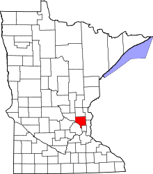 | |
| Township | ||
| CDP | ||
| Unincorporated community | ||
| Ghost towns/Neighborhoods | ||
| Footnotes | ‡This populated place also has portions in an adjacent county or counties | |
Coordinates: 45°05′10″N 93°15′48″W / 45.08611°N 93.26333°W