Martin County, Minnesota
| Martin County, Minnesota | |
|---|---|
 Martin County Courthouse in Fairmont | |
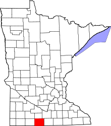 Location in the U.S. state of Minnesota | |
 Minnesota's location in the U.S. | |
| Founded | May 23, 1857[1] |
| Named for | Henry Martin |
| Seat | Fairmont |
| Largest city | Fairmont |
| Area | |
| • Total | 730 sq mi (1,891 km2) |
| • Land | 712 sq mi (1,844 km2) |
| • Water | 17 sq mi (44 km2), 2.4% |
| Population (est.) | |
| • (2016) | 19,829 |
| • Density | 29/sq mi (11/km2) |
| Congressional district | 1st |
| Time zone | Central: UTC−6/−5 |
| Website |
www |
Martin County is a county located in the U.S. state of Minnesota. As of the 2010 census, the population was 20,840.[2] Its county seat is Fairmont.[3] Martin County was named for Henry Martin, a pioneer settler.[4]
Geography
According to the U.S. Census Bureau, the county has a total area of 730 square miles (1,900 km2), of which 712 square miles (1,840 km2) is land and 17 square miles (44 km2) (2.4%) is water.[5]
Lakes
- Amber Lake: in Fairmont Township
- Big Twin Lake: in Elm Creek Township
- Bright Lake: in Tenhassen Township
- Budd Lake: in Fairmont Township
- Buffalo Lake: Cedar Township
- Buffalo Lake: there is another Buffalo lake in Rutland Township
- Canright Lake: in Rutland Township
- Cedar Lake: western part of the northern lake is in Cedar Township; eastern part of the northern lake is in Galena Township; southern lake is mostly in Cedar Township with the southern tip extending into Elm Creek Township
- Clayton Lake: in Tenhassen Township
- Clear Lake: in Lake Belt Township
- Clam Lake: in Fox Lake Township
- Creek Lake: northern half is in Galena Township southern half is in Fox Lake Township
- Eagle Lake: in Fraser Township
- East Chain Lake: mostly in East Chain Township, but western side is in Silver Lake Township
- Fish Lake: in Cedar Township
- Fish Lake: there is another Fish Lake in Lake Belt Township
- Fox Lake: is mostly in Fox Lake Township, but it has a few miles of shoreline in Manyaska Township
- Hall Lake: in Fairmont Township
- High Lake: in Rutland Township
- Iowa Lake: northern part is in Silver Lake Township and it extends south into Emmet County, Iowa
- Kiester Lake: in Rutland Township
- Lake Charlotte: in Rutland Township
- Lake George: in Fairmont Township
- Lake Imogene: western part in Fairmont Township; eastern part in Pleasant Prairie Township
- Lake Seymour: is Fox Lake Township
- Little Hat Lake: in Fairmont Township
- Little Twin Lake: in Elm Creek Township
- Martin Lake: in Rutland Township
- Mud Lake: in Fairmont Township
- Murphy Lake: in Westford Township
- North Lake: Cedar Township
- North Silver Lake: in Silver Lake Township
- Okamanpeedan Lake: mostly in Tenhassen Township, but the southern part extends into Emmet County, Iowa
- Perch Lake: in Westford Township
- Pierce Lake: in Rolling Green Township
- Rose Lake: in Fairmont Township
- Round Lake: in Fox Lake Township
- Round Lake: there is another Round Lake in Waverly Township
- Sager Lake: northern lake in Fairmont Township; southern lake in Silver Lake Township
- Sisseton Lake: in Fairmont Township
- South Silver Lake: in Silver Lake Township
- Susan Lake: in Lake Belt Township
- Temperance Lake: in Manyaska Township
- Tuttle Lake: in Tenhassen Township
- Watkins Lake: in Elm Creek Township
- Wilmert Lake: in Silver Lake Township
Major highways
Adjacent counties
- Watonwan County (north)
- Blue Earth County (northeast)
- Faribault County (east)
- Kossuth County, Iowa (southeast)
- Emmet County, Iowa (southwest)
- Jackson County (west)
- Cottonwood County (northwest)
Demographics
| Historical population | |||
|---|---|---|---|
| Census | Pop. | %± | |
| 1860 | 151 | — | |
| 1870 | 3,867 | 2,460.9% | |
| 1880 | 5,249 | 35.7% | |
| 1890 | 9,408 | 79.2% | |
| 1900 | 16,936 | 80.0% | |
| 1910 | 17,518 | 3.4% | |
| 1920 | 21,085 | 20.4% | |
| 1930 | 22,401 | 6.2% | |
| 1940 | 24,656 | 10.1% | |
| 1950 | 25,655 | 4.1% | |
| 1960 | 26,986 | 5.2% | |
| 1970 | 24,316 | −9.9% | |
| 1980 | 24,687 | 1.5% | |
| 1990 | 22,914 | −7.2% | |
| 2000 | 21,802 | −4.9% | |
| 2010 | 20,840 | −4.4% | |
| Est. 2016 | 19,829 | [7] | −4.9% |
| U.S. Decennial Census[8] 1790-1960[9] 1900-1990[10] 1990-2000[11] 2010-2016[2] | |||
As of the 2000 census,[12] there were 21,802 people, 9,067 households, and 6,047 families residing in the county. The population density was 31 people per square mile (12/km²). There were 9,800 housing units at an average density of 14 per square mile (5/km²). The racial makeup of the county was 97.22% White, 0.25% Black or African American, 0.10% Native American, 0.42% Asian, 0.02% Pacific Islander, 1.26% from other races, and 0.73% from two or more races. 1.93% of the population were Hispanic or Latino of any race. 51.6% were of German, 11.9% Norwegian, 5.9% Swedish and 5.0% English ancestry.
There were 9,067 households out of which 29.80% had children under the age of 18 living with them, 56.60% were married couples living together, 7.20% had a female householder with no husband present, and 33.30% were non-families. 30.00% of all households were made up of individuals and 15.20% had someone living alone who was 65 years of age or older. The average household size was 2.35 and the average family size was 2.92.
In the county, the population was spread out with 24.80% under the age of 18, 6.40% from 18 to 24, 24.90% from 25 to 44, 24.00% from 45 to 64, and 19.90% who were 65 years of age or older. The median age was 42 years. For every 100 females there were 95.30 males. For every 100 females age 18 and over, there were 91.50 males.
The median income for a household in the county was $34,810, and the median income for a family was $44,541. Males had a median income of $30,467 versus $21,780 for females. The per capita income for the county was $18,529. About 7.10% of families and 10.50% of the population were below the poverty line, including 15.10% of those under age 18 and 9.00% of those age 65 or over.
Communities
Cities
Townships
- Cedar Township
- Center Creek Township
- East Chain Township
- Elm Creek Township
- Fairmont Township
- Fox Lake Township
- Fraser Township
- Galena Township
- Jay Township
- Lake Belt Township
- Lake Fremont Township
- Manyaska Township
- Nashville Township
- Pleasant Prairie Township
- Rolling Green Township
- Rutland Township
- Silver Lake Township
- Tenhassen Township
- Waverly Township
- Westford Township
Unincorporated communities
Politics
| Year | Republican | Democratic | Third parties |
|---|---|---|---|
| 2016 | 67.1% 7,062 | 26.0% 2,733 | 7.0% 736 |
| 2012 | 60.7% 6,657 | 37.0% 4,054 | 2.3% 257 |
| 2008 | 56.3% 6,053 | 41.0% 4,413 | 2.7% 288 |
| 2004 | 57.1% 6,311 | 41.6% 4,590 | 1.3% 146 |
| 2000 | 54.8% 5,686 | 40.2% 4,166 | 5.0% 519 |
| 1996 | 40.9% 4,303 | 44.9% 4,718 | 14.2% 1,496 |
| 1992 | 38.2% 4,438 | 34.6% 4,019 | 27.2% 3,152 |
| 1988 | 53.3% 5,724 | 45.9% 4,922 | 0.8% 85 |
| 1984 | 60.7% 7,308 | 38.8% 4,673 | 0.5% 64 |
| 1980 | 57.4% 7,057 | 35.0% 4,301 | 7.6% 936 |
| 1976 | 51.9% 6,484 | 45.4% 5,672 | 2.7% 332 |
| 1972 | 64.6% 7,569 | 32.6% 3,816 | 2.8% 333 |
| 1968 | 59.4% 7,115 | 35.7% 4,271 | 4.9% 587 |
| 1964 | 53.8% 6,529 | 46.0% 5,575 | 0.2% 22 |
| 1960 | 66.8% 8,479 | 33.0% 4,194 | 0.2% 19 |
| 1956 | 71.2% 8,152 | 28.7% 3,289 | 0.1% 15 |
| 1952 | 77.6% 9,411 | 22.1% 2,673 | 0.3% 39 |
| 1948 | 43.3% 4,662 | 55.9% 6,015 | 0.8% 87 |
| 1944 | 53.7% 5,182 | 46.0% 4,443 | 0.3% 29 |
| 1940 | 59.8% 6,409 | 40.0% 4,290 | 0.2% 21 |
| 1936 | 31.5% 3,090 | 66.1% 6,492 | 2.5% 243 |
| 1932 | 38.3% 3,004 | 60.3% 4,731 | 1.5% 116 |
| 1928 | 64.1% 5,110 | 35.4% 2,822 | 0.5% 40 |
| 1924 | 56.2% 4,238 | 10.0% 751 | 33.8% 2,546 |
| 1920 | 78.5% 5,142 | 18.6% 1,221 | 2.9% 191 |
| 1916 | 47.2% 1,741 | 47.6% 1,756 | 5.3% 195 |
| 1912 | 17.5% 578 | 34.5% 1,141 | 48.1% 1,591 |
| 1908 | 59.1% 1,922 | 32.4% 1,054 | 8.6% 279 |
| 1904 | 70.7% 2,167 | 21.4% 656 | 8.0% 244 |
| 1900 | 54.7% 1,819 | 37.1% 1,233 | 8.2% 274 |
| 1896 | 54.3% 1,739 | 41.4% 1,327 | 4.3% 136 |
| 1892 | 57.2% 1,189 | 31.8% 661 | 11.0% 228 |
See also
References
- ↑ "Minnesota Place Names". Minnesota Historical Society. Retrieved March 18, 2014.
- 1 2 "State & County QuickFacts". United States Census Bureau. Archived from the original on July 14, 2011. Retrieved September 1, 2013.
- ↑ "Find a County". National Association of Counties. Retrieved 2011-06-07.
- ↑ Chicago and North Western Railway Company (1908). A History of the Origin of the Place Names Connected with the Chicago & North Western and Chicago, St. Paul, Minneapolis & Omaha Railways. p. 162.
- ↑ "2010 Census Gazetteer Files". United States Census Bureau. August 22, 2012. Archived from the original on September 21, 2013. Retrieved October 21, 2014.
- ↑ Nelson, Steven (2011). Savanna Soils of Minnesota. Minnesota: Self. pp. 65 - 67. ISBN 978-0-615-50320-2.
- ↑ "Population and Housing Unit Estimates". Retrieved June 9, 2017.
- ↑ "U.S. Decennial Census". United States Census Bureau. Retrieved October 21, 2014.
- ↑ "Historical Census Browser". University of Virginia Library. Retrieved October 21, 2014.
- ↑ "Population of Counties by Decennial Census: 1900 to 1990". United States Census Bureau. Retrieved October 21, 2014.
- ↑ "Census 2000 PHC-T-4. Ranking Tables for Counties: 1990 and 2000" (PDF). United States Census Bureau. Retrieved October 21, 2014.
- ↑ "American FactFinder". United States Census Bureau. Retrieved 2008-01-31.
- ↑ Leip, David. "Dave Leip's Atlas of U.S. Presidential Elections". uselectionatlas.org. Retrieved 9 October 2018.
Further reading
- William H. Budd, History of Martin County: A True and Complete History of the County from its Earliest Settlement Down to 1880. Fairmont, MN: The Independent, 1897.
- Roscoe C. Hunt, "Pioneer Physicians of Martin County Prior to 1900," Minnesota Medicine, vol. 25, no. 10 (Oct. 1942) and vol. 25, no. 11 (Nov. 1942).
- Ray F. Kesler, Service Record Book of Men and Women of World War II, Martin County. Fairmont, MN: n.p., n.d. [1950s].
- Martin County Historical Society, Martin County, 1857-1932: Diamond Jubilee Celebration and Homecoming, Fairmont, Minnesota, June 26 to July 4, 1932. Fairmont, MN: Martin County Historical Society, 1932.
- Martin County Home Council, Martin County's Heritage. Fairmont, MN.: Martin County Extension Home Council, 1972-1976.
- Allen L Moore, Historical Narrative of Martin County, Before 1850. Fairmont, MN: Martin County Historical Society, 1932.
- Arthur M. Nelson, Know Your Own County: A History of Martin County, Minnesota. Fairmont, MN: Martin County Historical Society, 1947.
- Arthur M. Nelson, Martin County Men in the Great War, 1917-1919. Fairmont, MN: Sentinel Publishing Co., 1920.
- Sentinel, A Pictorial History of Martin County, MN. Marceline, MO: Heritage House, 1992.
External links
Places adjacent to Martin County, Minnesota | ||||||||||
|---|---|---|---|---|---|---|---|---|---|---|
| ||||||||||
Municipalities and communities of Martin County, Minnesota, United States | ||
|---|---|---|
| Cities | | |
| Townships | ||
| Unincorporated communities | ||
| Footnotes | ‡This populated place also has portions in an adjacent county or counties | |