Crow Wing County, Minnesota
| Crow Wing County, Minnesota | |
|---|---|
 | |
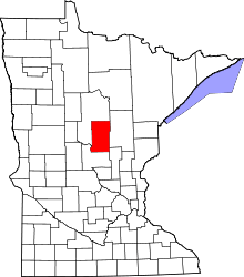 Location in the U.S. state of Minnesota | |
 Minnesota's location in the U.S. | |
| Founded |
May 23, 1857 (created) 1870 (organized)[1] |
| Named for | Crow Wing River |
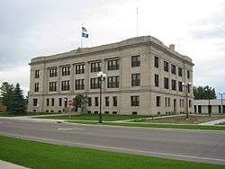
| Seat | Brainerd |
| Largest city | Brainerd |
| Area | |
| • Total | 1,157 sq mi (2,997 km2) |
| • Land | 999 sq mi (2,587 km2) |
| • Water | 157 sq mi (407 km2), 14% |
| Population (est.) | |
| • (2016) | 63,940 |
| • Density | 55/sq mi (21/km2) |
| Congressional district | 8th |
| Time zone | Central: UTC−6/−5 |
| Website |
www |
Crow Wing County is a county located in the U.S. state of Minnesota. As of the 2010 census, the population was 62,500.[2] Its county seat is Brainerd.[3] The county was formed in 1857 and organized in 1870.
Crow Wing County is included in the Brainerd, MN Micropolitan Statistical Area.
History
Crow Wing County was established on May 23, 1857 and organized March 3, 1870. It is named for the Crow Wing River,[4] which is itself named for an island in the river which is shaped like the wing of a crow.
Twenty years or more before the county was outlined and named, a trading post was established on the east side of the Mississippi River opposite the mouth of the Crow Wing River. In 1837 there was again a station of the fur traders facing the northern mouth of the Crow Wing River. A few years later it became the center of Indian trading and had the general supply store for the area. By 1866, the village contained about 600 whites and Chippewas and was one of the major population centers in Minnesota. Although the county seat,[5] Crow Wing was soon superseded by Brainerd and eventually became a ghost town known as Old Crow Wing, its memory is preserved by Crow Wing State Park.
Brainerd township was founded in 1870 when the Northern Pacific survey determined that the crossing of the Mississippi should be there. It became a city on November 19, 1881. The name was chosen in honor of the father in law of J. Gregory Smith, the first president of the Northern Pacific Railroad Company. Skeptical of Town's Growth Ex-governor Smith of Vermont may properly be called the father and founder of Brainerd. He gave it the name of his father-in-law, Lawrence Brainerd, the first president of the Vermont Central, has given it a memorial Congregational Church, which is now nearly completed, and had he continued president of the Northern Pacific would have undoubtedly dealt kindly and liberally by the town.

The Northern Pacific Railroad ran its first train to Brainerd, a special train, on March 11, 1871 and its regular passenger service began the next September. The first passenger train from the Twin Cities, by way of Sauk Rapids, came November 1, 1877.
The part of Crow Wing County west of the Mississippi was annexed from Cass County by an act of the Legislature on February 18, 1887, doubling its former area.
Geography
According to the U.S. Census Bureau, the county has a total area of 1,157 square miles (3,000 km2), of which 999 square miles (2,590 km2) is land and 157 square miles (410 km2) (14%) is water.[7]
Topography and vegetation
Crow Wing County has two state forests, the Crow Wing State Forest and the Emily State Forest. It also has the Cuyuna Lakes State Trail which lies in the Upper Mississippi River Basin. The topography of the region is gently rolling to flat, with waters and wetlands generously interspersed with the woodlands that cover the landscape. It is home to an abundance of wildlife. Visitors may see white-tailed deer, cottontail rabbit, snowshoe hare, raccoon, red fox, gray fox, coyote, mink, muskrat, squirrels, and beaver. Occasionally, American black bears may be observed. Bald eagles and osprey frequent the area, and many species of waterfowl also take advantage of the abundant aquatic habitat found in the marshes and lakes of the county.
There are many lakes and rivers in Crow Wing County. The main river is the Mississippi River although there are more smaller streams in the county too. It has about 417 recognized lakes. The top ten ranked according to size are:
- Gull Lake – 9,419 acres (38.12 km2)
- Pelican Lake – 8,254 acres (33.40 km2)
- Upper and Lower White Fish Lake – 7,372 acres (29.83 km2)
- North Long Lake – 5,997 acres (24.27 km2)
- Lake Edward – 2,576 acres (10.42 km2)
- Bay Lake – 2,393 acres (9.68 km2)
- Cross Lake (Minnesota) – 1,752 acres (7.09 km2)
- Round Lake – 1,645 acres (6.66 km2)
- Big Trout Lake – 1,343 acres (5.43 km2)
- Lower South Long Lake – 1,312 acres (5.31 km2)
Superfund site and environmental damage
Crow Wing County contains the Burlington Northern (Brainerd/Baxter) United States Environmental Protection Agency Superfund site. The site, located between the cities of Brainerd and Baxter, was the location of a Burlington Northern Railroad tie treatment plant. Wastewater generated from the wood-treating process was sent to two shallow, unlined ponds. This created a sludge which contaminated both the underlying soils and the groundwater with creosote and polynuclear aromatic hydrocarbons (PAHs).[8]
Major highways
Adjacent counties
- Aitkin County (northeast)
- Mille Lacs County (southeast)
- Morrison County (southwest)
- Cass County (northwest, north)
Demographics
| Historical population | |||
|---|---|---|---|
| Census | Pop. | %± | |
| 1860 | 269 | — | |
| 1870 | 200 | −25.7% | |
| 1880 | 2,319 | 1,059.5% | |
| 1890 | 8,852 | 281.7% | |
| 1900 | 14,250 | 61.0% | |
| 1910 | 16,861 | 18.3% | |
| 1920 | 24,566 | 45.7% | |
| 1930 | 25,627 | 4.3% | |
| 1940 | 30,226 | 17.9% | |
| 1950 | 30,875 | 2.1% | |
| 1960 | 32,134 | 4.1% | |
| 1970 | 34,826 | 8.4% | |
| 1980 | 41,722 | 19.8% | |
| 1990 | 44,249 | 6.1% | |
| 2000 | 55,099 | 24.5% | |
| 2010 | 62,500 | 13.4% | |
| Est. 2016 | 63,940 | [9] | 2.3% |
| U.S. Decennial Census[10] 1790-1960[11] 1900-1990[12] 1990-2000[13] 2010-2016[2] | |||

As of the 2000 census, there were 55,099 people, 22,250 households, and 15,174 families residing in the county. The population density was 55 people per square mile (21/km²). There were 33,483 housing units at an average density of 34 per square mile (13/km²). The racial makeup of the county was 97.64% White, 0.31% Black or African American, 0.78% Native American, 0.28% Asian, 0.01% Pacific Islander, 0.20% from other races, and 0.78% from two or more races. 0.69% of the population were Hispanic or Latino of any race. 32.5% were of German, 16.4% Norwegian, 9.4% Swedish, 6.2% Irish and 5.2% American ancestry.
There were 22,250 households out of which 30.20% had children under the age of 18 living with them, 56.70% were married couples living together, 8.00% had a female householder with no husband present, and 31.80% were non-families. 26.40% of all households were made up of individuals and 11.70% had someone living alone who was 65 years of age or older. The average household size was 2.43 and the average family size was 2.93.
In the county, the population was spread out with 24.80% under the age of 18, 8.10% from 18 to 24, 25.60% from 25 to 44, 24.40% from 45 to 64, and 17.10% who were 65 years of age or older. The median age was 39 years. For every 100 females there were 96.80 males. For every 100 females age 18 and over, there were 94.50 males.
The median income for a household in the county was $37,589, and the median income for a family was $44,847. Males had a median income of $33,838 versus $22,896 for females. The per capita income for the county was $19,174. About 6.50% of families and 9.80% of the population were below the poverty line, including 11.40% of those under age 18 and 9.90% of those age 65 or over.
Communities
Cities
Townships
- Bay Lake Township
- Center Township
- Crow Wing Township
- Daggett Brook Township
- Deerwood Township
- Fairfield Township
- Fort Ripley Township
- Gail Lake Township
- Garrison Township
- Ideal Township
- Irondale Township
- Jenkins Township
- Lake Edwards Township
- Little Pine Township
- Long Lake Township
- Maple Grove Township
- Mission Township
- Nokay Lake Township
- Oak Lawn Township
- Pelican Township
- Perry Lake Township
- Platte Lake Township
- Rabbit Lake Township
- Roosevelt Township
- Ross Lake Township
- Sibley Township (former)
- St. Mathias Township
- Timothy Township
- Wolford Township
Census-designated place
Other unincorporated communities
Unorganized territories
Original settlement
Politics
| Year | Republican | Democratic | Third parties |
|---|---|---|---|
| 2016 | 62.2% 22,287 | 30.6% 10,982 | 7.2% 2,573 |
| 2012 | 55.6% 19,415 | 42.3% 14,760 | 2.1% 745 |
| 2008 | 52.8% 18,567 | 45.1% 15,859 | 2.1% 739 |
| 2004 | 57.0% 19,106 | 41.8% 14,005 | 1.3% 434 |
| 2000 | 53.5% 15,035 | 40.0% 11,255 | 6.5% 1,838 |
| 1996 | 40.4% 10,095 | 44.7% 11,156 | 14.9% 3,712 |
| 1992 | 37.1% 9,112 | 36.3% 8,896 | 26.6% 6,531 |
| 1988 | 52.7% 11,017 | 46.3% 9,674 | 1.1% 220 |
| 1984 | 56.2% 11,362 | 43.1% 8,719 | 0.8% 151 |
| 1980 | 50.0% 10,844 | 43.0% 9,323 | 7.0% 1,510 |
| 1976 | 41.3% 8,072 | 54.5% 10,653 | 4.3% 839 |
| 1972 | 53.0% 8,774 | 44.3% 7,328 | 2.7% 449 |
| 1968 | 45.2% 6,687 | 50.1% 7,411 | 4.7% 697 |
| 1964 | 35.8% 5,131 | 64.1% 9,197 | 0.2% 21 |
| 1960 | 52.9% 7,727 | 46.8% 6,835 | 0.4% 52 |
| 1956 | 54.4% 6,657 | 45.4% 5,556 | 0.3% 30 |
| 1952 | 54.0% 6,992 | 45.4% 5,883 | 0.6% 81 |
| 1948 | 39.7% 4,702 | 57.2% 6,773 | 3.1% 370 |
| 1944 | 44.7% 4,500 | 54.7% 5,504 | 0.6% 63 |
| 1940 | 44.0% 5,524 | 54.8% 6,876 | 1.2% 150 |
| 1936 | 33.8% 3,611 | 61.5% 6,561 | 4.7% 501 |
| 1932 | 41.7% 3,991 | 52.9% 5,068 | 5.4% 519 |
| 1928 | 67.9% 6,436 | 30.1% 2,851 | 2.1% 196 |
| 1924 | 50.1% 4,230 | 4.9% 417 | 45.0% 3,802 |
| 1920 | 70.3% 5,262 | 14.4% 1,077 | 15.3% 1,142 |
| 1916 | 44.4% 1,715 | 40.6% 1,568 | 15.0% 578 |
| 1912 | 21.0% 691 | 21.5% 709 | 57.5% 1,897 |
| 1908 | 59.4% 1,681 | 23.4% 661 | 17.2% 487 |
| 1904 | 77.0% 2,150 | 11.9% 333 | 11.1% 309 |
| 1900 | 67.2% 1,803 | 30.0% 804 | 2.8% 75 |
| 1896 | 59.4% 1,701 | 37.2% 1,066 | 3.5% 99 |
| 1892 | 53.1% 916 | 30.1% 519 | 16.8% 290 |
See also
References
- ↑ "Minnesota Place Names". Minnesota Historical Society. Retrieved March 17, 2014.
- 1 2 "State & County QuickFacts". United States Census Bureau. Retrieved August 31, 2013.
- ↑ "Find a County". National Association of Counties. Archived from the original on May 31, 2011. Retrieved 2011-06-07.
- ↑ Warren Upham (1920). Minnesota Geographic Names: Their Origin and Historic Significance. Minnesota Historical Society. p. 154.
- ↑

- ↑ Nelson, Steven (2011).Savanna Soils of Minnesota. Minnesota: Self. pp. 53 - 56. ISBN 978-0-615-50320-2.
- ↑ "2010 Census Gazetteer Files". United States Census Bureau. August 22, 2012. Archived from the original on September 21, 2013. Retrieved October 6, 2014.
- ↑ "Burlington Northern (Brainerd/Baxter) Fact Sheet" Archived December 5, 2012, at the Wayback Machine., EPA, 07/13/12
- ↑ "Population and Housing Unit Estimates". Retrieved June 9, 2017.
- ↑ "U.S. Decennial Census". United States Census Bureau. Archived from the original on May 12, 2015. Retrieved October 6, 2014.
- ↑ "Historical Census Browser". University of Virginia Library. Retrieved October 6, 2014.
- ↑ "Population of Counties by Decennial Census: 1900 to 1990". United States Census Bureau. Retrieved October 6, 2014.
- ↑ "Census 2000 PHC-T-4. Ranking Tables for Counties: 1990 and 2000" (PDF). United States Census Bureau. Retrieved October 6, 2014.
- ↑ Leip, David. "Dave Leip's Atlas of U.S. Presidential Elections". uselectionatlas.org. Retrieved 10 April 2018.
External links
| Wikisource has the text of the 1879 American Cyclopædia article Crow Wing. |
Places adjacent to Crow Wing County, Minnesota | ||||||||||
|---|---|---|---|---|---|---|---|---|---|---|
| ||||||||||
Municipalities and communities of Crow Wing County, Minnesota, United States | ||
|---|---|---|
| Cities | | |
| Townships | ||
| Unorganized territories | ||
| CDP | ||
| Unincorporated communities | ||
| Indian reservation | ||
| Ghost towns | ||
| Footnotes | ‡This populated place also has portions in an adjacent county or counties | |
Cities in the Brainerd Lakes area, Minnesota | |||||
|---|---|---|---|---|---|
| Core City |  | ||||
| Surrounding communities |
| ||||
| Counties | |||||
† indicates a county seat. ‡ indicates that it is partially in the micropolitan area. § indicates a CDP. | |||||