Wabasha County, Minnesota
| Wabasha County, Minnesota | |
|---|---|
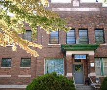
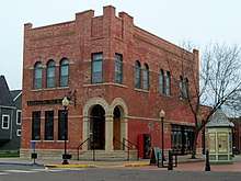 Old Wabasha City Hall in Wabasha, Minnesota. | |
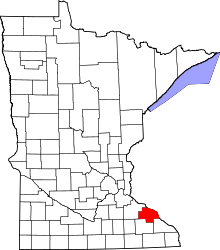 Location in the U.S. state of Minnesota | |
 Minnesota's location in the U.S. | |
| Founded | October 27, 1849[1] |
| Named for | Three successive chiefs of Mississippi bands of Dakota Indians[2] |
| Seat | Wabasha |
| Largest city | Lake City |
| Area | |
| • Total | 550 sq mi (1,424 km2) |
| • Land | 523 sq mi (1,355 km2) |
| • Water | 27 sq mi (70 km2), 4.8% |
| Population (est.) | |
| • (2016) | 21,273 |
| • Density | 41/sq mi (16/km2) |
| Congressional district | 2nd |
| Time zone | Central: UTC−6/−5 |
| Website |
www |
Wabasha County is a county located in the U.S. state of Minnesota. As of the 2010 census, the population was 21,676.[3] Its county seat is Wabasha.[4] The county was founded in 1849.
Wabasha County is included in the Rochester, MN Metropolitan Statistical Area.
Geography
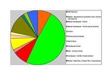
According to the U.S. Census Bureau, the county has a total area of 550 square miles (1,400 km2), of which 523 square miles (1,350 km2) is land and 27 square miles (70 km2) (4.8%) is water.[5] Wabasha is one of 17 Minnesota counties with more savanna soils than either forest or prairie soils.
Major highways
Lakes
- These lakes are located within the Upper Mississippi River National Wildlife and Fish Refuge
- Cross Lake
- Half Moon Lake
- Maloney Lake
- McCarthy Lake
- Peterson Lake
- Robinson Lake
Adjacent counties
- Pepin County, Wisconsin (northeast)
- Buffalo County, Wisconsin (east)
- Winona County (southeast)
- Olmsted County (south)
- Goodhue County (west, northwest)
Demographics
| Historical population | |||
|---|---|---|---|
| Census | Pop. | %± | |
| 1850 | 243 | — | |
| 1860 | 7,228 | 2,874.5% | |
| 1870 | 15,850 | 119.3% | |
| 1880 | 18,206 | 14.9% | |
| 1890 | 16,972 | −6.8% | |
| 1900 | 18,924 | 11.5% | |
| 1910 | 18,554 | −2.0% | |
| 1920 | 17,919 | −3.4% | |
| 1930 | 19,613 | 9.5% | |
| 1940 | 17,653 | −10.0% | |
| 1950 | 16,878 | −4.4% | |
| 1960 | 17,007 | 0.8% | |
| 1970 | 17,224 | 1.3% | |
| 1980 | 19,335 | 12.3% | |
| 1990 | 19,744 | 2.1% | |
| 2000 | 21,610 | 9.5% | |
| 2010 | 21,676 | 0.3% | |
| Est. 2016 | 21,273 | [7] | −1.9% |
| U.S. Decennial Census[8] 1790-1960[9] 1900-1990[10] 1990-2000[11] 2010-2016[3] | |||
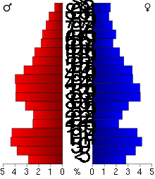
As of the 2000 census,[12] there were 21,610 people, 8,277 households, and 5,876 families residing in the county. The population density was 41 people per square mile (16/km²). There were 9,066 housing units at an average density of 17 per square mile (7/km²). The racial makeup of the county was 97.97% White, 0.25% Black or African American, 0.27% Native American, 0.43% Asian, 0.62% from other races, and 0.45% from two or more races. 1.68% of the population were Hispanic or Latino of any race. 53.3% were of German, 11.1% Norwegian, 7.3% Irish and 5.0% American ancestry.
There were 8,277 households out of which 33.80% had children under the age of 18 living with them, 60.80% were married couples living together, 6.50% had a female householder with no husband present, and 29.00% were non-families. 24.30% of all households were made up of individuals and 10.80% had someone living alone who was 65 years of age or older. The average household size was 2.57 and the average family size was 3.07.
In the county, the population was spread out with 27.10% under the age of 18, 7.20% from 18 to 24, 27.00% from 25 to 44, 23.80% from 45 to 64, and 15.00% who were 65 years of age or older. The median age was 38 years. For every 100 females, there were 100.00 males. For every 100 females age 18 and over, there were 97.90 males.
The median income for a household in the county was $42,117, and the median income for a family was $50,480. Males had a median income of $33,053 versus $24,316 for females. The per capita income for the county was $19,664. About 4.10% of families and 6.00% of the population were below the poverty line, including 6.00% of those under age 18 and 9.30% of those age 65 or over.
Communities
Cities
- Bellechester (partly in Goodhue County)
- Elgin
- Hammond
- Kellogg
- Lake City (partly in Goodhue County)
- Mazeppa
- Millville
- Minneiska (partly in Winona County)
- Plainview
- Wabasha (county seat)
- Zumbro Falls
Townships
Unincorporated communities
Politics
| Year | Republican | Democratic | Third parties |
|---|---|---|---|
| 2016 | 59.1% 6,989 | 32.7% 3,866 | 8.3% 977 |
| 2012 | 51.4% 6,049 | 46.0% 5,415 | 2.5% 299 |
| 2008 | 49.9% 5,935 | 47.5% 5,646 | 2.6% 312 |
| 2004 | 51.7% 6,120 | 46.9% 5,548 | 1.4% 167 |
| 2000 | 49.8% 5,245 | 42.9% 4,522 | 7.3% 764 |
| 1996 | 36.1% 3,452 | 47.3% 4,523 | 16.7% 1,598 |
| 1992 | 33.3% 3,397 | 36.6% 3,736 | 30.2% 3,084 |
| 1988 | 50.8% 4,681 | 48.2% 4,442 | 1.0% 92 |
| 1984 | 57.3% 5,299 | 41.9% 3,872 | 0.8% 76 |
| 1980 | 52.8% 4,986 | 39.3% 3,712 | 8.0% 755 |
| 1976 | 49.6% 4,484 | 47.4% 4,286 | 3.1% 279 |
| 1972 | 61.3% 5,158 | 35.9% 3,017 | 2.8% 238 |
| 1968 | 51.8% 4,081 | 43.8% 3,452 | 4.5% 353 |
| 1964 | 41.8% 3,133 | 58.2% 4,367 | 0.1% 4 |
| 1960 | 55.7% 4,566 | 44.3% 3,628 | 0.0% 3 |
| 1956 | 66.9% 4,728 | 32.6% 2,301 | 0.6% 39 |
| 1952 | 69.6% 5,461 | 30.0% 2,356 | 0.3% 26 |
| 1948 | 46.4% 3,297 | 52.5% 3,730 | 1.1% 75 |
| 1944 | 62.6% 4,213 | 36.9% 2,482 | 0.5% 33 |
| 1940 | 68.0% 5,656 | 31.9% 2,655 | 0.2% 13 |
| 1936 | 34.6% 2,663 | 53.6% 4,122 | 11.9% 912 |
| 1932 | 33.2% 2,319 | 65.1% 4,540 | 1.7% 119 |
| 1928 | 55.8% 3,944 | 43.7% 3,087 | 0.5% 32 |
| 1924 | 44.9% 2,834 | 10.2% 644 | 44.9% 2,829 |
| 1920 | 77.1% 4,907 | 20.0% 1,275 | 2.9% 182 |
| 1916 | 53.1% 1,787 | 43.1% 1,449 | 3.8% 129 |
| 1912 | 23.3% 797 | 41.6% 1,422 | 35.1% 1,198 |
| 1908 | 58.4% 2,150 | 38.4% 1,416 | 3.2% 118 |
| 1904 | 66.1% 2,315 | 30.9% 1,083 | 2.9% 102 |
| 1900 | 57.7% 2,114 | 38.4% 1,406 | 4.0% 145 |
| 1896 | 58.9% 2,530 | 37.9% 1,630 | 3.2% 138 |
| 1892 | 43.2% 1,580 | 48.5% 1,774 | 8.4% 307 |
See also
References
- ↑ "Minnesota Place Names". Minnesota Historical Society. Retrieved March 19, 2014.
- ↑ Upham, Warren (1920). Minnesota Geographic Names: Their Origin and Historic Significance. Minnesota Historical Society. p. 555.
- 1 2 "State & County QuickFacts". United States Census Bureau. Archived from the original on September 19, 2013. Retrieved September 1, 2013.
- ↑ "Find a County". National Association of Counties. Retrieved 2011-06-07.
- ↑ "2010 Census Gazetteer Files". United States Census Bureau. August 22, 2012. Archived from the original on October 6, 2014. Retrieved October 25, 2014.
- ↑ Nelson, Steven (2011). Savanna Soils of Minnesota. Minnesota: Self. pp. 43-48. ISBN 978-0-615-50320-2
- ↑ "Population and Housing Unit Estimates". Retrieved June 9, 2017.
- ↑ "U.S. Decennial Census". United States Census Bureau. Retrieved October 25, 2014.
- ↑ "Historical Census Browser". University of Virginia Library. Retrieved October 25, 2014.
- ↑ "Population of Counties by Decennial Census: 1900 to 1990". United States Census Bureau. Retrieved October 25, 2014.
- ↑ "Census 2000 PHC-T-4. Ranking Tables for Counties: 1990 and 2000" (PDF). United States Census Bureau. Retrieved October 25, 2014.
- ↑ "American FactFinder". United States Census Bureau. Retrieved 2008-01-31.
- ↑ Leip, David. "Dave Leip's Atlas of U.S. Presidential Elections". uselectionatlas.org. Retrieved 9 April 2018.
External links
- Wabasha-Kellogg (Minnesota) Convention and Visitors Bureau
- Wabasha County government's website
- Wabasha County Health and Demographic Data
Places adjacent to Wabasha County, Minnesota | ||||||||||
|---|---|---|---|---|---|---|---|---|---|---|
| ||||||||||
Municipalities and communities of Wabasha County, Minnesota, United States | ||
|---|---|---|
| Cities | | |
| Townships | ||
| Unincorporated communities | ||
| Footnotes | ‡This populated place also has portions in an adjacent county or counties | |